Transcription
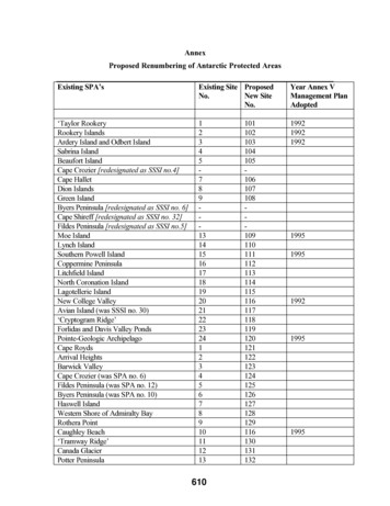
AnnexProposed Renumbering of Antarctic Protected AreasExisting SPA’sExisting Site ProposedNo.New SiteNo.Year Annex VManagement PlanAdopted‘Taylor RookeryRookery IslandsArdery Island and Odbert IslandSabrina IslandBeaufort IslandCape Crozier [redesignated as SSSI no.4]Cape HalletDion IslandsGreen IslandByers Peninsula [redesignated as SSSI no. 6]Cape Shireff [redesignated as SSSI no. 32]Fildes Peninsula [redesignated as SSSI no.5]Moe IslandLynch IslandSouthern Powell IslandCoppermine PeninsulaLitchfield IslandNorth Coronation IslandLagotellerie IslandNew College ValleyAvian Island (was SSSI no. 30)‘Cryptogram Ridge’Forlidas and Davis Valley PondsPointe-Geologic ArchipelagoCape RoydsArrival HeightsBarwick ValleyCape Crozier (was SPA no. 6)Fildes Peninsula (was SPA no. 12)Byers Peninsula (was SPA no. 10)Haswell IslandWestern Shore of Admiralty BayRothera PointCaughley Beach‘Tramway Ridge’Canada GlacierPotter 612712812911613013113219951995199219951995
Existing SPA’sHarmony PointCierva PointNorth-east Bailey PeninsulaClark PeninsulaNorth-west White IslandLinnaeus TerraceBiscoe PointParts of Deception Island‘Yukidori Valley’SvarthmarenSummit of Mount Melbourne‘Marine Plain’Chile BayPort FosterSouth BayAblation PointAvian Island [redesignated as SPA no. 21]Mount FloraCape Shireff (was SPA no. 11)Ardley IslandLions RumpWestern Branfield StraitDallmann BayExisting Site ProposedNo.New 50341513515236153Year Annex VManagement PlanAdoptedXIX: Measure 1 (1995)Revised Descriptions and Management Plans for Specially Protected AreasThe Representatives of the Consultative Parties,Recalling Recommendations XV-8 and XV-9 / VIII-3;Noting that revised Area Descriptions and proposed Management Plans have beenapproved by the Scientific Committee on Antarctic Research (SCAR);Noting also that the format of these revised Area Descriptions and proposed ManagementPlans accord with Article 5 of Annex V of the Protocol on Environmental Protection tothe Antarctic Treaty adopted under Recommendation XVI-10;Recommend to their Governments the following Measure for approval in accordance withparagraph 4 of Article IX of the Antarctic Treaty:For the Specially Protected Areas listed below:611
(i) the Descriptions inserted in Annex B. Specially Protected Areas, of the AgreedMeasures for the Conservation of Antarctic Fauna and Flora shall be deleted:(ii) the Descriptions and Management Plans of Specially Protected Areas, annexed tothis measure shall be inserted in Annex B. Specially Protected Areas, of the AgreedMeasures for the Conservation of Antarctic Fauna and Flora.The Specially Protected Areas concerned are:Area No. 13 Moe Island, South Orkney Islands (Annex A);Area No. 15 Southern Powell Island and adjacent islands, South Orkney Islands(Annex B)XIX: Measure 2 (1995)Revised Description and Management Plan for Sites of Special Scientific InterestThe Representatives of the Consultative Parties.Recommend to their Governments the following Measure for approval in accordance withparagraph 4 of Article IX of the Antarctic Treaty;For the Site of Special Scientific Interest mentioned below:i) the Management Plan inserted in the Annex to Recommendation XIII-8Facilitation of scientific research: Sites of Special Scientific Interest, be deleted;ii) the Management Plan of the Site of Special Scientific Interest, annexed to thisRecommendation, be inserted in the Annex to Recommendation XIII-8Facilitation of scientific research: Sites of Special Scientific Interest.The Site of Special Scientific Interest concerned is:SSSI No. 11 Tramway Ridge, Mt. Erebus, Ross Island.XIX: Measure 3 (1995)Antarctic Protected Area System: Specially Protected AreasSpecially Protected Area No. 24: Pointe-Geologie Archipelago (Jean Rostand, AlexisCarrel, Lamarck and Claude Bernard Islands, Bon Docteur Nunatak)The Representatives of the Consultative Parties,Recalling Recommendations XV-8 and XV-9;Noting that a Management Plan for the above Area has been approved by the ScientificCommittee on Antarctic Research (SCAR);Considering that the Point Geologic Archipelago is important as a representative area ofconsiderable biological, geological and aesthetic value; contains a high diversity of animalsand plants and is an important area for scientific research; and that long-term research and612
monitoring programmes on bird colonies and geology have been conducted in the areasince 1952.Recommend to their Governments the following Measure for approval in accordance withparagraph 4 of Article IX of the Antarctic Treaty:That the following Area shall be inserted in Annex B. Specially Protected Areas, of theAgreed Measures for the Conservation of Antarctic Fauna and Flora, together with theannexed Management Plan:Specially Protected Area No. 24Jean Rostand, Alexis Carrel, Lamarck and Claude Bernard Islands, Bon Docteur Nunatakand Breeding Marine Emperor Penguin Colony (140 to 140 02'E; 66 39'30" to66 40'33"S) in the heart of Pointe-Geologie Archipelago, coastal area of Adelie Land inthe vicinity of Astrolabe Glacier.XIX: Measure 4 (1995)Antarctic Protected Area System: New Historic Sites And MonumentsThe Representatives of the Consultative Parties,Recalling the Measures adopted in Recommendations l-IX, V-4, VI-14, VII-9, XII-7,XIII-16, and XIV-8;Recommend to their Governments the following Measure for approval in accordance withparagraph 4 of Article IX of the Antarctic Treaty; that the following historic monumentsbe added to the "List of Historic Monuments Identified and Described by the ProposingGovernment or Governments" annexed to Recommendation VII-9. Port Lockroy, Base A, on Goudier Island, off Wiencke Island, Antarctic Peninsula(Lat 64 49' S. Long 63 31' W). Of historic importance as an Operation Tabarinbase and for scientific research. Argentine Islands, Base F (Wordie House), South-west corner of Winter Island,one of the group known as the Argentine Islands (Lat 65 15' S. Long 64 16' W).Of historic interest as an example of an early British scientific base. Horseshoe Island, Base Y. Marguerite Bay, West Graham Land (Lat 67 49' S.Long 67 18' W). Noteworthy as a relatively unaltered and completely equippedbase of a later period. Blaiklock, the refuge hut nearby, is taken to be an integralpart of the base. Stonington Island, Base E, Northern end of Stonington Island, Marguerite Bay,West Graham Land (Long 68 11' S. 67 00' W). Of historical importance in theearly period of exploration and later British Antarctic Survey (BAS) history of the1960s and 70s. Message Post, Svend Foyn Island. A pole with a box attached was placed on 16January 1895 during the whaling expedition of Henryk Bull and Captain LeonardKristensen of the ship "Antarctica." It was examined and found intact by theBritish Antarctic Expedition of 1898-1900 and then sighted from the beach by the613
USS Edisto in 1956 and USCGS Glacier in 1965 (latitude approximately 71 52'S,longitude 171 10'E).Prestrud's Cairn, at the foot of main bluff Scott Nunataks, Queen AlexandraMountains. A small rock cairn at the foot of the main bluff on the north side of theAunataks by Lieutenant K. Prestrud on 3 December 1911 during the NorwegianAntarctic Expedition of 1910- 1912 (latitude 77 12' S. longitude 154 30' W).Rock Shelter "Granite House", Cape Geology, Granite Harbour. This shelter wasconstructed in December 1911 for use as a field kitchen by Taylor's secondgeological excursion during the British Antarctic Expedition of 1910-1913. It wasenclosed on three sides with granite boulder walls and used as a sledge to form aroof tree which supported seal skins anchored by heavy rocks (latitude 77 OO'E,longitude 162 32'E). A 1981 inspection of the "house" found it in good conditionalthough the sledge had begun to disintegrate. The most recent visit to the site in1990 reported that this deterioration was accelerating.Depot, Hells Gate Moraine, Inexpressible Island, Terra Nova Bay. An emergencydepot, consisting of a sledge loaded with supplies and equipment, was place on 25January 1913 by the British Antarctic Expedition at the close of the 1910-1913expedition. The depot was established by the crew of the Terra Nova to providesecurity in the event the ship was unable to return and pick them up (latitude74 56'S, longitude 163 48'E). In 1994, the sledge and supplies were removed inorder to stabilise their condition as wind and scoria particles had started to causerapid deterioration.Message Post, Cape Crozier. Erected on 22 January 1902 by Captain Robert FScott's Discovery Expedition (the National Antarctic Expedition of 1901-1904)and consists of a post to which a metal cylinder was attached containing anaccount of the Expedition's movements. It was intended to provide informationfor the expedition relief ships (latitude 77 27'S, longitude 169 16'E). The messagepost, although weathered, still stands, its grain blasted into high relief by countlessstorms. The record cylinder no longer exists.Message Post, Cape Wadsworth Coulman Island. A metal cylinder nailed to a redpole 8 meters above sea level placed by Captain R. F. Scott on 15 January 1902.He also painted the rocks behind the post red and white to make it moreconspicuous (latitude 73 l9'S, longitude 169 47'E).Whalers Bay Whaling Station, Whalers Bay, Deception Island. Established in1906 by Captain Adolfo Andresen. Of historical importance as an example of anAntarctic whaling station.XIX: Measure 5 (1995)Historic Sites And Monuments: AmendmentThe Representatives of the Consultative Parties,Recalling Recommendations I-IX, VI-14, VII-9, XII-7, XIII-16 and XIV-8;Recommend to their Governments the following Measure for approval in accordance withparagraph 4 of Article IX of the Antarctic Treaty:614
That the description of Historic Site Number 14, which is contained in the "List ofHistoric Monuments Identified and Described by the proposing Government orGovernments" annexed to Recommendation VII-9, be amended to read:Site Number 14: Inexpressible Island, Terra Nova Bay, Scott Coast"Site of ice cave at Inexpressible Bay, Terra Nova Bay, constructed in March 1912 byVictor Campbell's Northern Party, British Antarctic Expedition, 1910-13 (Lat 70 54'S,Long 163 43'E). The Party spent the winter of 1912 in this ice cave.XIX: Resolution 7(1995)Extension of the Expiry Dates for Sites of Special Scientific InterestThe Representatives of the Consultative Parties,Recalling Recommendations VIII-3 and XII-5Noting that:i) experience of the practical effect of the Management Plans for these sites hasshown them to be an effective means of reducing the risks of harmful interferencein areas of special interest;Recommend that:1. The date of the expiry of Site Numbers 1, 3, 8, 9, 14, 15, 16, 17, 19, 21 beextended from 31 December 1995 to 31 December 2000.2. The Governments of the Consultative Parties should use their best endeavours toensure, in accordance with paragraphs 3 and 4 of Recommendation VII-3, that theManagement Plans for these sites are complied with.XIX: Resolution 8 (1995)New Historic Sites and Monuments:Suggested Guidelines for the Designation of Historic SitesRecalling Recommendations I-IX V-4, VI-14, VII-9, XII-7, XIII-16 and XIV-8;Recommend that the following Guidelines for the Designation of Historic Sites and/orMonuments should be used by the Governments of the Consultative Parties in proposingsites for the “List of Historic Monuments Identified and Described by the proposingGovernment or Governments.”GuidelinesProposals for Historic Sites and/or Monuments should address one or more of thefollowing: A particular event of importance in the history of science or exploration ofAntarctica occurred at the place;615
A particular association with a person who played an important role in the historyof science or exploration of Antarctica;A particular association with a notable feat of endurance or achievement;Representative of, or forms part of, some wide-ranging activity that has beenimportant in the development of knowledge of Antarctica;Particular technical or architectural value in its materials, design or method ofconstruction;The potential, through study, to reveal information or has the potential to educatepeople about significant human activities in Antarctica;Symbolic or commemorative value for people of many nations.XIX: Resolution 9 (1995)Uniform Model for Management PlansThe Representatives of the Consultative Parties,Recalling the requests made by ATCM XVII and ATCM XVIII that SCAR should assistParties in reviewing and revising Management Plans to conform with the provisions ofAnnex V of the Protocol on Environmental Protection to the Antarctic Treaty, andconsider how a model could be developed to facilitate the preparation of new and revisedManagement Plans;Recognizing that a uniform model for such plans would eliminate repetition and wouldmake them easier to use;Recommend that:The structure of the Management Plan for Specially Protected Area No. 13, adoptedunder Measure 1, be regarded as a model of all new and revised Management Plans forprotected areas for the purposes of Annex V.XVII-2: Revised Descriptions and Proposed Management Plans for SpeciallyProtected AreasThe Representatives,Recalling Recommendations XV-8 and XV-9;Noting that revised Area Descriptions and proposed Management Plans have beenapproved by the Scientific Committee on Antarctic Research (SCAR);Noting also that the format of these revised Area Descriptions and proposed ManagementPlans accord with Article 5 of Annex V of the Protocol on Environmental Protection tothe Antarctic Treaty adopted under Recommendation XVI-10;Recommend to their Governments that for the Specially Protected Areas listed below:i) the Descriptions inserted in Annex B, Specially Protected Areas, of the AgreedMeasures for the Conservation of Antarctic Fauna and Flora be deleted;616
ii) the Descriptions and Management Plans of Specially Protected Areas, annexed tothis Recommendation, be inserted in Annex B, Specially Protected Areas, of theAgreed Measures for the Conservation of Antarctic Fauna and Flora.The Specially Protected Areas involved are:Area No. 1 Taylor Rookery, Mac Robertson Land;Area No. 2 Rookery Islands, Holme Bay, Mac Robertson Land;Area No. 3 Ardery Island and Odbert Island, Budd Coast;Area No. 20 ‘New College Valley’, Caughley Beach, Cape Bird, Ross Island.XVII-3: Antarctic Protected Areas: New Historic Sites and MonumentsWooden Plaque and Rock Cairn at Penguins BayRecalling Recommendations I-IX, V-4, VI-14, VII-9 XII-7, XIII-16 and XIV-8;Recommend to their Governments that the following historic monuments be added to the“List of Historic Monuments Identified and Described by the Proposing Government orGovernments” annexed to Recommendation VII-9, and that thereafter they be accordedthe respect and protection required by the Recommendation recalled above:Wooden plaque and rock cairn located at Penguins Bay, southern coast of SeymourIsland (Marambio), James Ross Archipelago (64 16'00"S, 56 39'10"W). This plaquewas placed on 10 November 1903 by the crew of a rescue mission of the ArgentinianCorvette ‘Uruguay’ in the site where they met members of the Swedish expedition led byDr Otto Nordenskjöld. The text of the wooden plaque reads as follows:“10.XI.1903 ‘Uruguay’ (Argentine Navy) in its journey to give assistanceto the Swedish Antarctic expedition.”In January 1990, a rock cairn was erected by Argentina in memory of this event in theplace where the plaque is located.Extract from Report of XVII ATCMThe Antarctic Protected Area System: Review and implementation of the system(96) The Meeting considered measures that could be taken to improve the AntarcticProtected Area System and to begin to give effect to provisions of Annex V of theProtocol. The Meeting was assisted in this regard by a paper (XVII ATCM/WP 4)summarising the results of a Workshop on Antarctic Protected Areas held jointly bySCAR and IUCN, 29 June--2 July 1992. The Meeting noted that some aspects of thispaper related to issues beyond the Protected Area System and that these were notaddressed explicitly.(97) The Meeting noted that, when Annex V of the Protocol enters into force, all SPAsand SSSIs designated as such by past ATCMs will be designated as Antarctic SpeciallyProtected Areas and be renamed and renumbered accordingly. The Meeting recognized617
that the management plans for many SSSIs and SPAs may need to be revised at that timeto ensure they conform with the provisions of the Protocol. The Meeting also recognizedthat the Committee for Environmental Protection, which will be established when theProtocol enters into force, will be required to provide advice. To assist in this regard, itwas agreed that the Parties which originally proposed the existing SSSIs and SPAs shouldreview their management plans and be prepared to submit proposed revisions forconsideration when the Protocol enters into force. It was also agreed that SCAR could beasked to provide assistance to Parties in reviewing and revising management plans toconform with the provisions of the Protocol.(98) With regard to the previous point, the Meeting was advised that SCAR waspreparing a handbook to assist in the preparation of management plans. The Meetingwelcomed this information, recognizing that the handbook could be useful to the Partiesand the CEP, as well as SCAR. It urged SCAR to complete and make available thehandbook as soon as possible.(99) The Meeting was also advised that the joint SCAR/IUCN Workshop on ProtectedAreas had begun revision of the ecosystem classification system developed by SCAR toassist in identifying areas that might usefully be included in the Antarctic Protected AreaSystem. The Meeting noted that the classification system might be useful to the Partiesfor deciding, and to the CEP for providing advice on, measures necessary to meet therequirements of Article 3(2) of Annex V of the Protocol which specifies that the Partiesshall seek to include certain types of areas in the series of Antarctic Specially ProtectedAreas. The Meeting urged SCAR and IUCN to complete the revision and make itavailable as soon as possible.(100) The Meeting noted that Annex V of the Protocol will prohibit entry into AntarcticSpecially Protected Areas except in accordance with a permit issued under Article 7 of theAnnex. The Meeting urged Parties that have not already done so to institute a permitsystem to begin to give effect to the permitting provisions.(101) With respect to the preceding point, the Meeting recognized that effectiveimplementation of Annex V will require, where appropriate, that ASPAs and ASMAs aremarked and posted with signs, and that all persons visiting Antarctic are aware of thelocations and purposes of ASPAs and ASMAs, and the prohibitions or restrictions onentry and activities that can be conducted in these Areas. Towards this end, the Meetingurged that all Parties take such steps as possible to begin to give effect to Article 9 ofAnnex V. The Meeting also urged that the need to make such information available beconsidered in the development of the Data Information System referenced in paragraphs82 and 83 of this Report.(102) The Meeting noted that ASPAs, ASMAs, and Historic Sites and Monuments mayneed to be visited periodically to ensure that the objectives of their management plans arebeing met. The Meeting further noted that a suggested list of information that should becollected and included in reports of site visits was developed at, and was appended to theReport of, the XIVth ATCM. The Meeting agreed that Parties, through their NationalCommittees, would ask SCAR to review this list and provide advice on:i) how it should be revised to reflect the provisions of the Protocol618
ii) how site visits should be carried outiii) how the results of such visits should be reported to be most useful inimplementing the Protocol.(103) Attention was called to the fact that, under Annex V of the Protocol, it would beappropriate in some cases to adopt management plans specifying conditions for visitingand activities that can be carried out in the vicinity of Historic Sites and Monuments.Attention was also drawn to the fact that a number of abandoned work sites may havescientific and historic values and that programme operators should consider suchpossibilities before initiating clean-up operations to give effect to Article 1(5) of Annex IIIof the Protocol.XVI-2: Antarctic Protected Area System: New Sites of Special Scientific InterestThe Representatives,Recalling Recommendations VIII-3 and VIII-4;Noting that Management Plans have been prepared and approved by the ScientificCommittee on Antarctic Research (SCAR) for certain Sites of Special Scientific Interestadditional to those already designated;Considering that it would be advantageous to gather experience of the practical effect ofthe Management Plans prepared for these sites;Recommend to their Governments that they voluntarily take account of the ManagementPlans, annexed to this Recommendation, for the following sites;Site No. 33: Ardley Island, Maxwell Bay, King George Island, South ShetlandIslands. (Location: 62 13'S, 58 54'W).Site No. 34: Lions Rump, King George Island, South Shetland Islands. (Location:62 8'S, 58 08'W).XVI-3: Antarctic Protected Area System: New Marine Sites of Special ScientificInterestThe Representatives,Recalling Article II of the Antarctic Treaty, Recommendations VII-3, VIII-3 and XIV-6;Noting that Management Plans have been prepared and approved by the ScientificCommittee on Antarctic Research (SCAR) for two Marine Sites of Special ScientificInterest;Considering that it would be advantageous to gather experience of the practical effect ofthe Management Plans prepared for these Sites;Recommend to their Governments that they voluntarily take account of the ManagementPlans, annexed to this Recommendation, for the following Sites:619
No. 35 Western Bransfield Strait, off Low Island, South Shetland Islands;No. 36 East Dallmann Bay, off Brabant Island.XVI-4: Antarctic Protected Area System: Specially Protected Areas:Re-designation of Site of Special Scientific Interest No. 30, Avian Island, MargueriteBay, Antarctic Peninsula as Specially Protected Area No. 21The Representatives,Recalling Recommendation XV-8 and XV-9;Noting that a Management Plan has been approved by the Scientific Committee onAntarctic Research (SCAR);Considering that Avian Island, together with its littoral zone is unique in the AntarcticPeninsula region for its abundance and diversity of breeding seabirds, including AdéliePenguins, Blue-eyed Shags, Giant Petrels, Dominican Gulls, South Polar Skuas andWilson's Petrels, and that the colony of Adélie Penguins is the largest on the AntarcticPeninsula, and that other species are at or near the southern limits of their breeding range,and that the island is vulnerable to visits by tourists, and uncontrolled personnel;Recommend to their Governments that:i) the designation of Avian Island as Site of Special Scientific Interest No. 30 underRecommendations VIII-3 and VIII-4 be terminated;ii) the number 30 should not be used for another Site of Special Scientific Interest;iii) the following area of outstanding ornithological interest be inserted in Annex B,Specially Protected Areas, of the Agreed Measures for the Conservation ofAntarctic Fauna and Flora (1964), along with the Management Planaccompanying the description of the said Specially Protected Area: SpeciallyProtected Area No. 21, Avian Island, Marguerite Bay, Antarctic Peninsula(67 46'S, 68 54'W).XVI-5: Antarctic Protected Area System: Sites of Special Scientific Interest:Interim Guidelines: Site of Special Scientific Interest No. 6: Byers Peninsula,Livingston Island, South Shetland IslandsThe Representatives,Recalling Recommendation VIII-4 and the Management Plan for Site of Special ScientificInterest No. 6: Byers Peninsula, Livingston Island, South Shetland Islands, annexedthereto;Noting that at its Twenty-First Meeting the Scientific Committee on Antarctic Research(SCAR), held at Sao Paulo, Brazil (24-27 July 1990), reviewed the Management Plan andscientific interest of SSSI No. 6: Byers Peninsula, Livingston Island, South ShetlandIslands;Recommend to their governments that:620
i) the Management Plan for Site of Special Scientific Interest No. 6: ByersPeninsula, Livingston Island, South Shetland Islands, annexed toRecommendation VIII-4 be terminated;ii) they voluntarily take account of the Management Plan, annexed to thisRecommendation, for Site No. 6: Byers Peninsula, Livingston Island, SouthShetland Islands.XVI-6: Antarctic Protected Area System: Specially Protected Areas:Revised descriptions and proposed management plans for Specially Protected AreasThe Representatives,Recalling Recommendation XV-8 and XV-9;Noting that revised Area Descriptions and proposed Management Plans have beenapproved by the Scientific Committee on Antarctic Research (SCAR);Recommend to their Governments that for the Specially Protected Sites listed below:i) the Descriptions inserted in Annex B, Specially Protected Areas, of the AgreedMeasures for the Conservation of Antarctic Fauna and Flora be deleted;ii) that the Descriptions and Management Plans of Specially Protected Areas,annexed to this Recommendation, be inserted in Annex B, specially ProtectedAreas, of the Agreed Measures for the Conservation of Antarctic Fauna andFlora.The Specially Protected Areas involved are:Site No. 8: Dion Islands, Marguerite Bay, Antarctic PeninsulaSite No. 9: Green Island, Berthelot Islands, Antarctic PeninsulaSite No. 13: Moe Island, South Orkney IslandsSite No. 14: Lynch Island, South Orkney IslandsSite No. 15: Southern Powell Island, and adjacent islands, South Orkney IslandsSite No. 16: Coppermine Peninsula, Robert Island, South Shetland IslandsSite No. 18: North Coronation Island, South Orkney IslandsSite No. 19: Lagotellerie Island, Marguerite Bay, Antarctic PeninsulaXVI-7: Antarctic Protected Area System:Sites of Special Scientific Interest: Extension of DesignationThe Representatives,Recalling Recommendation VIII-3, VIII-4, XII-5 and XIII-7;Noting that:621
1. in accordance with paragraph 2 of Recommendation VIII-3, the Scientific Committeeon Antarctic Research (SCAR), at its Twenty-first Meeting at Sao Paulo, Brazil (24-27July 1990) had reviewed the eight Sites of Special Scientific Interest designated inRecommendations VIII-4, XIII-8 and XIV-5;2. experience of the practical effect of the Management Plans for these sites has shownthem to be an effective means of reducing the risks of harmful interference in areas ofspecial scientific interest;3. no changes to the Management Plans of these sites had been proposed by SCAR.Recommend to their Governments that:i) The date of expiry of designation of Sites:No. 4 - Cape Crozier, Ross Island;No. 5 - Fildes Peninsula, King George Island, South Shetland Islands;No. 7 - Haswell Island;No. 10 - Caughley Beach, Cape Bird, Ross Island;No. 11 - Tramway Ridge, Mt Erebus, Ross Island;No. 12 - Canada Glacier, Lake Fryxell, Taylor Valley, Victoria Land;No. 18 - North-West White Island, McMurdo Sound be extended to 31December 2001; and that,ii) The date of expiry of designation of Site No. 22 - Yukidori Valley, Langhovde,Lutzow-Holm Bay be extended to 31 December 2003.iii) They use their best endeavours to ensure, in accordance with paragraphs 3 and 4of Recommendation VIII-3, that the Management Plans of these Sites areobserved.XVI-8: Antarctic Protected Area System:Specially Protected Area No. 22: Cryptogram Ridge; Mount Melbourne, VictoriaLandThe Representatives,Recalling Recommendations XV-8 and XV-9;Noting that a Management Plan has been prepared and approved by the ScientificCommittee on Antarctic Research (SCAR):Considering that Cryptogram Ridge on the southern rim of the main summit crater ofMount Melbourne includes areas of geothermal activity which are ice-free and surroundedby numerous ice hummocks and scattered ice towers, and that the geothermal groundsupports a unique community of bryophytes, algae and microbiota including very rarespecies, and that this fragile habitat is of exceptional biological interest and, to maintain itsunique pristine state, should be afforded maximum protection from human influence;622
Recommend to their Governments that the following area of outstanding scientific interestbe inserted in Annex B, Specially Protected Areas, of the Agreed Measures for theConservation of Antarctic Fauna and Flora, together with the annexed Management Plan:Specially Protected Area No. 22Cryptogram Ridge, Mount Melbourne, Victoria Land. Mount Melbourne (74 21'S,164 42'E) lies between Wood Bay and Campbell Glacier, northern Victoria Land, onthe western side of the Ross Sea.XVI-9: Antarctic Protected Area System:Specially Protected Area No. 23: Forlidas Pond and Davis Valley PondsThe Representatives,Recalling Recommendations XV-8 and XV-9;Noting that a Management Plan has been prepared and approved by the ScientificCommittee on Antarctic Research (SCAR);Considering that the Area contains some of the most southerly freshwater ponds known inAntarctica containing plant life, and that these ponds and their immediate catchmentsshould be protected as examples of unique near-pristine ecosystems which should beafforded maximum protection from human influence;Recommend to their Governments that the following Area of outstanding scientific interestbe inserted in Annex B, Specially Protected Areas, of the Agreed Measures for theConservation of Antarctic Fauna and Flora, together with the annexed Management Plan:Specially Protected Area No. 23Forlidas Pond and Davis Valley Ponds, situated near the east end of the Dufek Massifat position 8
Scott's Discovery Expedition (the National Antarctic Expedition of 1901-1904) and consists of a post to which a metal cylinder was attached containing an account of the Expedition's movements. It was intended to provide information for the expedition relief ships (latitude 77 27'S, longitude 169 16'E). The message