Transcription
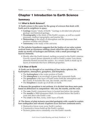
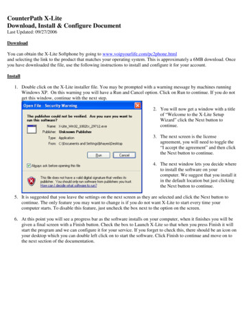
LiteThe Evolution of the Rio Grandefall 2012 issue 32This view of the upper Rio Grande gorge looks north past Ute Mountain (the cone-shapedmountain beyond the snow) and into southern Colorado. The San Luis Hills, left and justbeyond Ute Mountain, formed a topographic barrier to ancient Lake Alamosa. Between450,000 and 300,000 years ago the level of this lake rose high enough to spill over topographic low points in these hills. The water flowed southward and started eroding the gorgethat we see in the photograph. This gorge is still actively being eroded downward and ismigrating northward. In the distant future, this erosion will eventually extend the gorge intothe Alamosa area. Photo courtesy of Chris Dahl-Bredine.2012 mIn This Issue.The Evolution of the Rio Grande How Do Volcanoes Help Us Understand River History?Earth Briefs: Catastrophic Sedimentation, New Mexico StyleCrossword Puzzle New Mexico’s Most Wanted Minerals—ClayNew Mexico’s Enchanting GeologyClassroom Activity: Topographic Model of Northern White Rock CanyonThrough the Hand Lens Rockin’ Around New Mexico Short Items of InterestN EW M EXICO B UR EAU O F G EOLOGY & M INER AL R ESOURCESry!versainnA20thruosarkA DIV ISION OFN EW M EXICO T /litegeology/current.html
The Evolution of the R io Gr ande Daniel J. Koning and Sean D. Connella convexity (or bump) in its upper reaches, the reasons forThe Rio Grande is an essentialwhich will be discussed below.feature of New Mexico and theAmerican Southwest, and muchGeologically, the Rio Grande is a relatively young featurehas been written about its geology,that flows down a fault-bounded depression of Earth’s crustecology, and history. From itsknown as the Rio Grande rift (see Issue 31 of Lite Geology,headwaters in the ColoradoSpring-2012). The river’s development is closely tied to lowerRockies, the Rio Grandeing of Earth’s crust in the rift (tectonic subsidence), whichflows through a wide range ofover the past 30 million years has created a series of basinsenvironments before endingthat trend north-south through the center of New Mexico.in the Gulf of Mexico.Mountains may lie on one or both sides of these basins.At 1,896 miles (3,051Major tributaries of the Rio Grande, such as the Rio Chama,km) in length, it is theoriginate outside of the Rio Grande rift and add water tofourth longest river in thethe river. Other rifts in the world commonly containcontiguous United States.large river systems (e.g., White Nile, Rhine, lowerThe Rio Grande owes itsMississippi) and provide important sources ofexistence to the San Juanwater, oil, and natural gas.and Sangre de CristoThe Rio Grande has changedMountains in southernconsiderably sinceColorado and northernits formation. InNew Mexico, whosefact, for mostheights allow them to receiveof its existencesubstantial precipitation.it never flowedStreams from these mountainsto the sea, butmerge to form a single river thatended in variousflows south through New Mexico,inland basins.where it provides vital water forThe Rio Grandefarms and communities. Newmainly extendedMexico would be a very differentddownstreamplace without the Rio Grande.over time, ratherLike the Nile River is tothan upstream,Egypt, the Rio Grande is toreaching theNew Mexico— supporting aMap showing the Rio Grande watershed. The river begins in the San Juan MountainsGulfof Mexicoverdant oasis in an otherwise of Colorado and flows south through the center of New Mexico. South of El Paso,between1,600,000Texas, the Rio Grande coincides with the boundary between the United States andbrown and dry landscape.Mexico. It enters the Gulf of Mexico at Brownsville, where it has formed a delta.and 600,000 yearsRivers are an integral partago. At times theof the hydrologic and rock cycles. They are conduits that move Rio Grande carried relatively more water (discharge) and lesswater from the mountains and across the continent. Manysediment; at other times, it carried less discharge and morerivers ultimately flow into the sea; however, some desert riverssediment. Over geologic time, changes in the balance ofempty into closed basins where water eventually evaporatesdischarge versus sediment load filled rift basins and sculptedinto the air. Rivers also act as conveyor belts for sedimentthe landscape.(such as sand, gravel, and mud) eroded from nearby hillslopesWe begin the story of the Rio Grande at about 28 millionand mountain ranges. Water currents transport sedimentyears ago (abbreviated Ma), when its namesake rift was justdownstream, breaking it down along the way. Ultimately,starting to form in northern New Mexico. During and beforemuch of the sediment is laid down in a delta at the river’sthis time, an episode of extensive volcanic activity left muchmouth. For a number of reasons, including sediment breakdown and addition of water from tributaries, rivers commonly of New Mexico covered in lava flows, volcanic ash, andvolcanic sediment. This volcanism resulted in a rearrangedevelop a concave-up, “graded” profile in which erosion andment of earlier streams that flowed generally to the southeast.deposition tend to smooth out major irregularities. AlthoughTectonic stretching of the crust began to form fault-boundedgenerally concave-up, the profile of the Rio Grande containsbasins of the Rio Grande rift. At this time, there was nonew mexico bureau of geology & mineral resourceslite geology fall 20122
through-going river like the modern Rio Grande. The mapon page 4 (left column) shows an example of what north-central New Mexico and southern Colorado looked like about23 million years ago. Volcanoes were present in the Taos areaand southern Colorado, and streams flowed outward awayfrom these volcanoes into surrounding basins.Volcanic activity diminished between 17 and 16 Ma. Thiswas followed by a period of extensive faulting (between 16and 9 Ma) that formed rapidly subsiding basins. Northernstreams flowed into a basin near Alamosa, Colorado. Streamsdraining the southern Sangre de Cristo Mountains, betweenTaos and Santa Fe, converged to form a south-flowing riverthat is considered the ancestral Rio Grande. This ancestralriver merged with southeast-flowing rivers draining theColorado Plateau. The Rio Grande ended in a playa (ashallow lake that occasionally dries up) in the southernAlbuquerque Basin, where it deposited extensive reddishbrown clay and silt between Belen and Socorro. Rivers andstreams had difficulty filling the Albuquerque Basin, oneof the largest and deepest basins of the rift, with sedimentbecause the rate of tectonic subsidence exceeded the rate ofsedimentation. This created a closed topographic depression,from which the Rio Grande could not escape for severalmillions of years.At around 5 Ma, sedimentation filled the AlbuquerqueBasin, and the river lengthened southward, flowing throughsmaller rift basins near Socorro, Truth or Consequences,Hatch, and Las Cruces. Between 5 and 2 Ma, the river alternatively ended in various perennial, shallow lakes and playasnear the southern boundary of New Mexico, collectivelyElevation (km)Longitudinal profile of the upper Amazon River*43Coordination Committee (State of New Mexico), published by Bohannan–Huston, Inc., Albuquerque, NM, 2006.210400050006000Distance from Atlantic Ocean (km)called Lake Cabeza de Vaca. After 2.3 Ma, the Rio Grandeextended past the El Paso area and began to flow along thesouthwestern Texas border toward Big Bend. Finally, the RioGrande reached the Gulf of Mexico between 1.6 and 0.6 Maand began forming a delta along the coast.* Data are from Pirmez (1994)30002000Distance from Gulf of Mexico (km)Del RioEl PasoSocorroTaos gorgeGulf of Mexico0Ojinaga1Red RiverTaosRio ChamaAlbuquerque2Alamosa3San Juan Mts.4San Luis HillsLongitudinal profile of the Rio GrandeElevation (km)Rectified aerial photograph (orthophoto) showing the junction ofthe Rio Grande (right) with one of its major tributaries, the RioChama (left). The rivers are flowing to the lower right corner of thephoto (to the south-southeast). Note the straighter shape of theRio Grande and the more sinuous, meandering shape of the RioChama. When this photo was taken, the Rio Chama was carryingmore suspended clay than the Rio Grande, which accounts for itslight-brown color. Rivers that carry more clay tend to have a moremeandering shape, and that seems to be true for the two rivers inthis photograph. Image from New Mexico Geospatial Data AcquisitionRio Grande10000Longitudinal profile of the Rio Grande and comparison to the AmazonRiver. A profile refers to the shape of something seen from the side. Tocreate a profile view of the river course, one plots the elevation of a riverfor progressive distances upstream from its mouth. The profile of theAmazon River exhibits a concave-up shape expected for “graded” rivers.Note the bump in the upper part of the Rio Grande, coinciding with theTaos gorge. The river here is undergoing relatively rapid erosion that willslowly lengthen the gorge upstream toward Alamosa. Eventually, erosionwill result in a smoother longitudinal profile.new mexico bureau of geology & mineral resourcesThis downstream progression of the Rio Grande is thoughtto be the result of a balance of competing factors. Evidencesuggests that fault activity and basin subsidence began todiminish after about 5 Ma. This slowing of subsidencemeant that sedimentation of the ancestral Rio Grande couldestablish a sufficient slope to allow southward flow across theAlbuquerque Basin and smaller basins to the south. Also, after7 Ma regional climatic changes resulted in an overall increasein precipitation and the beginning of the monsoonal summerstorms. These climatic changes would allow rivers to delivermore sediment to basins as well as increase the amount ofwater in the river, the latter facilitating lake spill-over.lite geology fall 20123
into the lake. Once this ridge was breached, a new riverflowed south and joined the Rio Grande. This integrationevent created a major irregularity in the river profile in theform of a bump in the Taos area, shown in the longitudinalprofile—called a knickzone. The river has been eroding inthe area of the bump ever since, in an attempt to achieve asemblance to a graded river profile. This erosion has createdthe Taos gorge, whose steep upper end coincides with lots ofrapids and erosion. Erosion in the Taos gorge will continueover geologic time until much of the knickzone is smoothedout by the river.San JuanMountains38 NAlamosaColorado38 NNSan LuisBasinTaosRangeNew MexicoAlamosa36 NColoradoSangre de CristoMountainsTaosNew MexicoTaos36 NSanta FeSanta FeAlbuquerqueExplanationAlbuquerqueRift-related basin34 NAlbuquerqueBasinExplanationBelenEolian dune fieldInferred lakemikmLake or playaSocorro34 NInferred streams005101020 mi2030km106 WPaleogeographic map of north-central New Mexico for 23 millionyears ago, showing streams flowing off of volcanic highlands into theAlbuquerque and San Luis Basins.An example of an ancient lake spill-over event is interpretednear Alamosa, Colorado, near the present-day headwatersof the Rio Grande. For most of the past 2.6 million years,streams draining high peaks around the northern San LuisBasin were not connected with the Rio Grande, but ratherended in a closed basin containing Lake Alamosa, whichslowly filled in with sediment. Glacial-interglacial climatecycles characterized this time period; these cycles affectedstream discharges and caused the lake to vary in size. Excitingnew research by Michael Machette and Cal Ruleman (U.S.Geological Survey) indicates that this lake spilled over alow volcanic ridge at its southern end between 450,000 and300,000 years ago, probably during major glacial climaticevents (ice ages) that probably increased stream dischargesnew mexico bureau of geology & mineral resourcesTruth orConsequencesLas Cruces32 NEl PasoNew MexicoTexasMexico106 WPaleogeographic map of central New Mexico for 13 millionyears ago. At this time, the Rio Grande flowed from the Taosarea into a playa south of Albuquerque. Modified from variousworks by Greg Mack and personal communication from John Hawley.lite geology fall 20124
38 NNAlamosaColoradoNew MexicoTaos36 NSanta FeExplanationAlbuquerqueBasin not connectedto Rio GrandeBasin whose streamsconnected to RioGrandeBelenend of Rio Grande15-6 MaLake or playaPosition of RioGrande at giventime periodSocorro34 NAlternating pathsof Rio Grande intoLake Cabeza deVaca.6.9-4.9 Ma 4.94.7 MaMa Millions of yearsTruth orConsequences500Las Cruces32 N2.6-0.8Ma4.5?MaMexico101020 mi2030km3-0.8MaNew MexicoTexasOver the past few million years, Earth’s climate alternatedbetween glacial and interglacial periods (including the presentday). This resulted in episodic changes in the balance of riverdischarge and the sediment load carried by rivers. Times ofhigh discharge and low sediment loads increased the erosivecapability of the Rio Grande and caused it to progressivelycarve a river valley over the past 800,000 years. Beforethen, the river was mostly depositing sediment, and its oldercourses sometimes were quite far from its present position. Inthe Albuquerque area, for example, the ancestral Rio Grandeonce flowed within a mile of the western front of the SandiaMountains. Only later did it shift west and erode its presentvalley. Sand-filled channels from these older river pathwaysare buried under Albuquerque and are valuable aquifers.In summary, the Rio Grande has responded in various waysto tectonic and climatic changes. Between 23 and 5 Ma, itended in a playa located between Belen and Socorro. Highsubsidence rates in the Albuquerque Basin hampered theriver’s ability to fill it with sediment. Not until tectonic subsidence rates decreased after about 5 Ma did the Rio Grandeextend into playas and shallow lakes in the El Paso area,where it remained between 5 and 2 Ma. The Rio Grandeeventually reached the Gulf of Mexico between 1.6 and 0.6Ma, ending its long journey to the sea. Times of higher waterdischarge and lower sediment load balances during glacialinterglacial cycles over the past 800,000 years resulted inerosion of the present-day valley of the Rio Grande. Higherstream discharges into Lake Alamosa between 450,000 and300,000 years ago, following progressive sedimentation of thebasin, caused the lake to spill over to the south and connectwith the Rio Grande—an interesting example of upstreamextension in what is otherwise a story of downstreamlengthening.Lake Cabezade Vaca 2.3-2.2 Ma106 WPaleogeographic map of central New Mexico for 3.0–2.6 millionyears ago, showing the timing of extension of the Rio Grandefrom its former terminus between Belen and Socorro. At thistime period, the river ended in a group of perennial, shallowlakes and playas in the El Paso area, collectively called LakeCabeza de Vaca. The extent and shape of this lake probablychanged over this time period, depending on where the RioGrande was flowing into it. The river spilled out of Lake Cabezade Vaca about 2.3–2.2 million years ago and flowed southeasttoward the Gulf of Mexico. Modified from various works by GregMack and personal communication from John Hawley.new mexico bureau of geology & mineral resourceslite geology fall 20125
Additional ReadingThe Rio Grande— a River Guide to the Geology and Landscapesof Northern New Mexico by P. W. Bauer, 2011. New MexicoBureau of Geology and Mineral Resources, 120 pp.Late Cenozoic drainage development in the southeastern Basinand Range of New Mexico, southeasternmost Arizona and western Texas by S. D. Connell, J. W. Hawley, and D. W. Love,2005. In New Mexico’s Ice Ages, New Mexico Museum ofNatural History & Science Bulletin No. 28, pp. 125–150. S.G. Lucas, G. Morgan, and K. E. Zeigler (editors).History of Cenozoic North American drainage basin evolution,sediment yield, and accumulation in the Gulf of Mexico Basinby W. E. Galloway, T. L. Whiteaker, and P. Ganey-Curry,2011. Geosphere, v. 7, n. 4, pp. 938–973.A View of the River by L. Leopold, 1994. University ofCalifornia, Berkeley, 298 pp.Ancient Lake Alamosa and the Pliocene to middle Pleistoceneevolution of the Rio Grande by M. N. Machette, D. W.Marchetti, and R. Thompson, 2007. In Rocky MountainSection Friends of the Pleistocene Field Trip—QuaternaryGeology of the San Luis Basin of Colorado and New Mexico,by M. N. Machette, M.-M. Coates, and M. L. Johnson (editors). U.S. Geological Survey, Open-File Report 2007-1193,pp. 157–167.Pliocene and Quaternary history of the Rio Grande, the axialriver of the southern Rio Grande rift, New Mexico by G. H.Mack, W. R. Seager, et. al., 2006. USA: Earth-ScienceReviews, v. 79, pp. 141–162.How Do Volcanoes Help Us Understand River History? Nelia DunbarIn order to understand how river systems work, geologistsneed to be able to determine the time scales over whichrivers form and deposit sediments. This can be very difficult,because most river sediment is made up of older rocks thathave been eroded from surrounding highlands, so datingthe sediment itself does not provide an accurate age of thesedimentation, only of the ages of the sediment source. Forinstance, in Rio Grande sediments there are pieces of rocksthat are more than a billion years old, but the river itself ismuch younger.Fortunately, some rivers, such as the Rio Grande, aresurrounded by volcanoes that give scientists one good way todate rock layers. When these volcanoes erupt, they producelava flows or ash fall deposits that can be interlayered withthe river sediments. These volcanic eruptions typically takeplace over a period of days to months, very short time scales,geologically speaking. When a volcanic deposit is interlayered with river sediments it forms a bed of known age,which is called a “time-stratigraphic marker.” Many lavaflows or ash fall deposits can be dated very accurately andprecisely using radioisotopic techniques. Once the age ofone of these time-stratigraphic marker beds is known, thenthe age of the river sediments on either side of the bed cannew mexico bureau of geology & mineral resourcesbe inferred. Wherever you find that volcanic deposit, youknow that the sediments below are probably slightly olderthan the marker bed, and the sediments above are slightlyyounger. You can also say that sediments associated with agiven marker bed, even if they are in geographically differentareas, are probably close to the same age.Lava flows tend to travel only a few tens of miles fromtheir source, so are only useful for determining the ageof river sediments in a very local area. However, ash falleruptions from powerful supervolcanoes like the JemezMountains, can deposit a thin layer of ash hundreds or eventhousands of miles from the vent. So, these ash layers, whenfound in river sediments, can be used to determine ages ofsediments over very large areas. Volcanic ashes from twolarge Jemez Mountain eruptions, one erupted 1.6 millionyears ago and the other 1.2, have been used as marker bedsin Rio Grande sediments. Well-dated volcanic ashes fromsupervolcanoes in Yellowstone, Wyoming, and Long Valley,California, have also been recognized in New Mexico riversediments, providing time lines to understand the chronological history of the Rio Grande.lite geology fall 20126
E arth Briefs —C atastrophic Sedimentation,New M exico Style Douglas BlandWhen we think of accumulations of gravel, sand, silt, andclay that eventually form sedimentary rock layers, mostpeople envision a gradual buildup of material over longperiods of time. Picture a gently flowing river or stream,quietly moving small amounts of sediment with the current.While this process accounts for most sedimentary deposits,major sedimentation events can occur very quickly, depositedby devastating torrents of water, mud, and debris. Althoughuncommon, very large rainfall events can cause catastrophicsedimentation, but modest rains that fall on barren ordisturbed ground can yield the same result. Recent examplesinclude flash floods that followed the 2011 Las Conchaswildfire in the Jemez Mountains of northern New Mexico.This fire denuded the slopes of mountains and canyons ofvegetation that previously held the soil in place. In addition,the heat and ash made the soil hydrophobic, meaning waterdoes not easily soak in. Therefore, during the typical summer rains, the amount of runoff into arroyos and once quietstreams was much higher than usual, eroding the landscape,carrying huge amounts of ash, soil, sand, boulders, and plantdebris with it. As flows moved into lower elevations, sedimentwas deposited as the flood waters spread out over flatter areas,slowed down, and lost the energy needed to carry sediment.Damage was extensive. Similar effects occurred in 2012 whenthe largest fire in New Mexico’s history, the Whitewater–Baldy fire, scorched more than a quarter of a million acresin the Gila Wilderness. At the same time, the Little Bear firenear Ruidoso burned 242 residential structures.Flash flood deposits in 2011 at Dixon Apple Orchard.Photo courtesy of Channel 13 News.Dixon’s Apple Orchard sits in the bottom of CochitiCanyon north of Cochiti Reservoir. The Las Conchas fireburned much of the drainage area for the creek that flows inthe bottom of the canyon, as well as the ranch house, otheroutbuildings, and about 10 percent of the trees in the ornew mexico bureau of geology & mineral resourceschard. Less than two months later flash floods roared downthe canyon, tossing trucks and tractors, filling in irrigationponds that were 30 to 40 feet deep, and depositing severalfeet of sediment in parts of the orchard and stream valley. Ifthis sediment is preserved, the rock record will show a thicklayer of material that was laid down in just one night.U.S. Senator Tom Udall (top), Kris Schafer (bottom right), andWalter Dasheno, governor of Santa Clara Pueblo at Santa ClaraPueblo on July 7, 2012. Flooding followed the 2011 Las Conchasfire. Photo courtesy of the U.S. Army Corps of Engineers.More than 65 percent of Bandelier National Monumentburned in the fire. The main Visitors Center is located in thebottom of Frijoles Canyon. Although the fire spared most ofthe archaeological ruins and the Visitors Center, the watershedfor the canyon was torched. Scientists anticipated flash floodsthat could wipe out all the facilities. To prevent disaster, wallsof sandbags and concrete barriers were placed around theVisitors Center and adjacent buildings. The main bridge acrossthe creek was removed, because floods carrying debris wouldcollect against the bridge, causing water to back up and floodthe buildings. Flash floods in September 2011 ravaged thecanyon, and washed out the remaining bridges. Sand bags andbarriers were displaced, but the measures were successful inprotecting the newly renovated Visitors Center. A flash floodin Frijoles Canyon in early July of 2012 once again took outbridges that had been replaced in the past year.Some of the sediment and debris washed down the canyonswill be preserved in place, but much of it has been washedinto the Rio Grande. The current will eventually movemost of it downstream, depositing it in Cochiti Reservoir.Geologists in the distant future may puzzle over an unusually thick layer of ash-laden sediment from the early 21stcentury in the Rio Grande valley north of Albuquerque.Today’s geologists find similar deposits all over the world.lite geology fall 20127
Rio Grande Crossword PuzzleDouglas ion of Taos gorge propagation2.the Rio Grande begins here4.fourth longest river in the U.S.3.river in European rift6.tectonic subsidence creates this4.fault bounded depression7.glacial climate5.tributary to the Rio Grande8.river in African rift10. location of southern Colorado basin9.abbreviation for “million years ago”11. river profiles are generally this12. type of map13. type of prehistoric lake north of Socorro14. type of river profile15.rivers entering the ocean form this16. prehistoric lake near El Paso17.rivers may end in this type of basin18. rivers carrying clay tend to do thisThe answers to the clues are located in the Evolutionof the Rio Grande article in this issue of Lite Geology.The solution to the puzzle is found on the last page ofthis issue.new mexico bureau of geology & mineral resourceslite geology fall 20128
New Mexico's MostWANTEDmineralsVirgil W. LuethclayScanning electron microscope image of a typical mixture ofclay minerals found in shale. Scale bar is approximately 10microns. Photo courtesy of the U.S. Geological Survey.Description:Clay is a term applied to a variety of fine-grained minerals with many different properties such as plasticity and a sheet structure similar to mica. Most clay minerals consist of combinations of aluminum andsilica with water, and they are known generically as hydrous aluminosilicates. These minerals commonlyare mixed with other minerals like quartz, feldspar, carbonates, and micas (their close relatives). Theseparticles require analytical methods like X-ray diffraction or electron microscopy for identification.wanted for:Humans have used clay minerals for thousands of years. More than one-half of the world’s populationlives in clay structures, New Mexico being famous for adobe clay buildings. Clay has long been usedto make pottery, and the earliest forms of writing are preserved on clay tablets. It is used for cement,filtering, and paper making (giving magazine paper its shiny coating), and we even use clays for certainmedical conditions where absorption of fluid is necessary, especially poultices and anti-diarrheals. Theimpermeable nature of clay makes it useful for water barriers in landfills and for blocking the spread oftoxic elements.hideout:last seenat large:aliases:Clays form from the long-term chemical weathering of feldspar, the most abundant mineral on Earth,accumulating in most soils and becoming the most abundant sedimentary rock on Earth, shale. Claysalso form by the interaction of hydrothermal solutions on silicate rocks.Clay is found throughout New Mexico: in the air during windstorms, suspended in our rivers, and inthe shale rocks under our feet. Large deposits of clay are found in the Mancos Shale in northwest NewMexico, in the Pierre and Lewis shales in the northeast, and in the Percha in southern New Mexico.Hydrothermal clay can be found in the natural alteration scars associated with molybdenite ore depositsalong the Red River canyon.Today, clays are commonly classified into five groups, and individual clay minerals are given a uniquespecies name. These five groups are: kaolinite (20 species), smectite (a mixed-layer group with 27 species),illite (a mica group with 49 species), sepiolite (3 species), and chlorite (11 species). In most clay samples,more than one clay species usually is present.new mexico bureau of geology & mineral resourceslite geology fall 20129
New M exico’s E nchanting GeologyPaul Bauerwhere is this?Photo courtesy of Chris Dahl-Bredine.The Rio Grande has cut a deep, photogenic canyon throughthe basalts of the Taos Plateau volcanic field. This downstream, aerial view of the southern Rio Grande gorge displaysthe Gorge Bridge, the Servilleta Basalt in the gorge walls,and the Paleoproterozoic metamorphic rocks of the PicurisMountains in the distance. The lands east (left) of the gorgebelong to Taos Pueblo. The western rim of the gorge (designated as part of the National Wild & Scenic River System)provides stunning views of the gorge along the 9-mile BLMWest Rim Trail.Although the exact age of the gorge is unknown, it mustpostdate the youngest Servilleta Basalt flows (2.6 millionyears). Recent work by USGS geologists suggests that theRio Grande in Colorado first became integrated with the RioGrande here in New Mexico about 300,000 years ago, andtherefore much of the river incision must be that young.The river has cut through approximately 650 feet of basalthere, one of the thickest sequences known in the volcanicfield. By volume, the Servilleta Basalt dominates the TaosPlateau and may contain as much as 50 cubic miles of olivinetholeiite lava. Most of the basalts in the gorge have eruptedfrom known vents to the west, although nothing precludesthe existence of buried volcanic vents to the east. Here thenew mexico bureau of geology & mineral resourcesbasalt consists of three thick flow-packages of basalt (lower,middle, and upper), which are typically separated by thingravel layers. Each flow-package is composed of hundreds ofcoalesced individual flows.This 15-mile Taos Box section of the Rio Grande is arguably the finest day-long whitewater adventure in the country.From the launch site at Arroyo Hondo to the take out at theTaos Junction Bridge, the river drops 400 feet, for an averageof 27 feet/mile. For comparison, the Colorado River throughthe Grand Canyon drops about 8 feet/mile. The thrillinggrand finale of the Box, starting with the formidable 12-footdrop at Powerline Falls, is 3.5 miles of near-continuouswhitewater known as the Rio Bravo section.The Gorge Bridge is 650 feet above the river, and 1,272 feetlong, making it the 2nd or 3rd highest bridge on the nationalhighway system, and the 2nd longest steel deck truss bridgein the U.S. Completed in 1965 at a cost of 2,153,000, theroadway contains pumice in the concrete mix, thus substantially lightening the structure. This bridge was deemed themost beautiful span in the U.S. in 1966. Hollywood scoutshave taken note of the location, and the bridge has appearedin many movies, including Easy Rider (1969), Twins (1988),Natural Born Killers (1994), and Terminator Salvation (2009).lite geology fall 201210
Classroom Activity Susan Welch and Douglas BlandTopographic Model of NorthernWhite Rock Canyonvolcanic activity over the past 10 million years, including thegigantic eruptions that formed the Valles caldera and JemezMountains between one and two million years ago.Grade Level: Grades 6–12Objectives:A topographic map is a two-dimensional
Taos and Santa Fe, converged to form a south-flowing river that is considered the ancestral Rio Grande. This ancestral river merged with southeast-flowing rivers draining the Colorado Plateau. The Rio Grande ended in a playa (a shallow lake that occasionally dries up) in the southern Albuquerque Basin, where it deposited extensive reddish-