Transcription
Supplementary Report No. 1 The revitalised FSR/FEH rainfall-runoff method FEH SUPPLEMENTARY REPORT No. 1 Thomas Rodding Kjeldsen The revitalised FSR/FEHrainfall-runoff methodKjeldsenCentre for Ecology & Hydrology FEHSR1covers.pmd 1 8/20/2007, 4:34 PM
Flood Estimation HandbookSupplementary Report No. 1iFLOOD ESTIMATION HANDBOOKSUPPLEMENTARY REPORT No.1S3925 prelims10.pmd18/16/2007, 12:48 PM
The revitalised FSR/FEH rainfall-runoff methodFLOOD ESTIMATION HANDBOOKSUPPLEMENTARY REPORT No.1iiS3925 prelims10.pmd28/16/2007, 12:48 PM
Flood Estimation HandbookSupplementary Report No. 1The revitalised FSR/FEHrainfall-runoff methodThomas Rodding KjeldsenCentre for Ecology & HydrologyiiiFLOOD ESTIMATION HANDBOOKSUPPLEMENTARY REPORT No.1S3925 prelims10.pmd38/16/2007, 12:48 PM
The revitalised FSR/FEH rainfall-runoff method Centre for Ecology & Hydrology 2007ISBN for this volume: 0 903741 15 7Centre for Ecology & HydrologyCrowmarsh GiffordWallingfordOxfordshireOX10 8BBUKTel: 01491 838800Fax: 01491 692424http://www.ceh.ac.ukDisclaimerThe Flood Estimation Handbook and related software offer guidance to those engagedin rainfall and flood frequency estimation in the UK. Despite careful preparation, this firstedition may contain typographical or other errors that affect use of the procedures and/or the numerical values obtained. Readers are encouraged to report suspected errorsto the Centre for Ecology & Hydrology (CEH). Once confirmed, errors will be noted and,where circumstances allow, corrected. CEH will maintain a list of FEH errata/corrigendaaccessible via the World Wide Web. The location of the list will be advertised through theReFH homepage: http://www.ceh.ac.uk/refh. Neither the named authors nor CEH norits parent bodies give any commitment to otherwise communicate errors, whether suspectedor confirmed. Nor is liability accepted for losses arising from use of the Flood EstimationHandbook, its procedures or related software, howsoever caused. The appearance of thenames of organisations sponsoring the research and its implementation does not signifyofficial endorsement of any aspect of the Flood Estimation Handbook. Neither the namedauthors nor CEH nor its parent bodies have approved any instruction that use of FloodEstimation Handbook procedures be made mandatory for particular applications.Cover photo: Flooding in Oxford (John Packman, CEH)FLOOD ESTIMATION HANDBOOKSUPPLEMENTARY REPORT No.1ivS3925 prelims10.pmd48/16/2007, 12:48 PM
ContentsContentsPreface and acknowledgementsviiNotationixChapter 11.11.2IntroductionBackgroundDevelopment of event-based rainfall-runoff models forhydrological designThe revitalised FSR/FEH design methodGuide to this report11Chapter 22.12.22.32.42.52.6The Revitalised Flood Hydrograph (ReFH) modelIntroductionModel conceptLoss modelRouting modelBaseflow modelApplication of the ReFH model4455689Chapter 33.13.23.33.4ReFH model parameter estimationIntroductionThe gauged siteThe ungauged siteInformation transfer from donor sites1010111820Chapter 44.14.24.34.44.54.64.7T-year flood estimationIntroductionThe ReFH design flood simulation packageDesign rainfall inputsDesign soil moisture contentInitial baseflowAdjustment coefficientDerivation of T-year flood events2424242633333334Chapter 55.15.25.3Application – considerations and limitationsIntroductionUser guidanceOther applications38383839Chapter 66.16.26.3Worked examplesIntroductionT-year flood estimationSimulation of a notable event424242471.31.4122References54Appendix A The ReFH loss model56vFLOOD ESTIMATION HANDBOOKSUPPLEMENTARY REPORT No.1S3925 prelims10.pmd58/16/2007, 12:48 PM
The revitalised FSR/FEH rainfall-runoff methodA.1A.2A.3IntroductionThe FSR/FEH loss modelThe ReFH loss model565656Appendix B Antecedent soil moistureB.1B.2IntroductionThe soil moisture model5858Appendix C ReFH model parameters61Appendix D Calibration of the ReFH design method64FLOOD ESTIMATION HANDBOOKSUPPLEMENTARY REPORT No.1viS3925 prelims10.pmd5868/16/2007, 12:48 PM
PrefacePrefaceThe research described in Flood Estimation Handbook Supplementary Report No. 1 wasundertaken at the Centre for Ecology & Hydrology, Wallingford, Oxfordshire.ContributorsContributions were made by: Lisa Stewart, John Packman, Sonja Folwell, Adrian Bayliss,Chak Fai Fung, Judith Nutter, Cecilia Svensson, Christel Prudhomme, Beate Gannon, DavidMorris, Sandie Clemas and George Goodsell. The ReFH spreadsheet tool and data analysissoftware were developed principally by Matt Fry.SponsorsBoth the development (FD1913) and the Dissemination (SC040029) of the revitalised FSR/FEH rainfall-runoff method were funded by the Joint Defra / Environment Agency Floodand Coastal R&D programme.AcknowledgementsThe CEH project team wishes to acknowledge the following people and organisations forassistance provided during the project:The National Water Archive, the British Atmospheric Data Centre, the EnvironmentAgency and the Scottish Environment Protection Agency for providing the rainfall data usedin this study;The HiFlows-UK project for making available the HiFlows-UK data set of annualmaximum peak flow series;The Project Steering Group: Paul Webster (Hydro-Logic Ltd), David MacDonald (Blackand Veatch) and Peter Spencer (Environment Agency).viiFLOOD ESTIMATION HANDBOOKSUPPLEMENTARY REPORT No.1S3925 prelims10.pmd78/16/2007, 12:48 PM
The revitalised FSR/FEH rainfall-runoff methodFLOOD ESTIMATION HANDBOOKSUPPLEMENTARY REPORT No.1viiiS3925 prelims10.pmd88/16/2007, 12:48 PM
NotationNotationThe following are the main symbols and abbreviations used throughout this report. Othersymbols have just local meaning and are defined where they occur. All units are metric exceptwhere otherwise DMPRESSPROPWETAreal reduction factor5-day antecedent precipitation index (mm)Catchment area (km2)Baseflow (m3s-1)Initial baseflow (m3s-1)Baseflow recession constant (or lag) (hours)Baseflow rechargeInitial soil moisture content (mm)Maximum soil moisture capacity (mm)Catchment wetness index (mm)Duration of rainfall event (hours)Depth-duration-frequencyDaily soil moisture decay rateMean drainage path length (km)Mean drainage path slope (m km-1)Field capacity (mm)Flood Event ArchiveFlood Estimation HandbookFlood Studies ReportDatabase of flood peak flow series for UK gauging stationsHydrology of Soil Types (soil classification)Integrated Hydrological Digital Terrain ModelInstantaneous unit hydrographMet. Office Rainfall and Evaporation Calculation SystemOrdinary least squareTotal rainfall depth (mm)Probability Distributed ModelPredicted error sum of squaresProportion of time when SMD was less than or equal to 6 mmduring the period 1961-90.Direct runoff (m3s-1)Flow (m3s-1)Revitalised Flood Hydrograph modelS-curveStandard average annual rainfall (1961-90) (mm)Seasonal correction factor for d-hour/day rainfallMean soil moisture depth (mm)Soil moisture deficit (mm)Standard percentage runoff (%)SPR derived from HOST soil classification (%)Return period (years)Unit hydrograph time to peak (hours)Unit hydrograph responseUnit OD ESTIMATION HANDBOOKSUPPLEMENTARY REPORT No.1S3925 prelims10.pmd98/16/2007, 12:48 PM
The revitalised FSR/FEH rainfall-runoff methodUkURBEXT1990UpwWLSxDegree of kink in the standard unit hydrographExtent of urban and suburban land cover (year 1990)Unit hydrograph peakWeightWeighted least squareFLOOD ESTIMATION HANDBOOKSUPPLEMENTARY REPORT No.1
IntroductionChapter 1 Introduction1.1 BackgroundThis report is a key element in the Environment-Agency funded project (SC040029) todisseminate the revitalised FSR/FEH rainfall-runoff method. In addition to this report, twoindependent software packages have been developed to support the use of the method.Further details of the software can be found on the CEH website http://www.ceh.ac.uk/refh.Although the FSR/FEH rainfall-runoff method was originally conceived during theresearch that led to publication of the Flood Studies Report (FSR) (NERC, 1975) more than30 years ago, it continues to be widely used alongside statistical methods of flood frequencywhere estimates of complete flood hydrographs or total flood volumes are required. Themethod can be used to estimate the total flow from any rainfall event, whether it is anobserved event or one that is statistically derived (a design storm). With the publication of theFlood Estimation Handbook (FEH) (Institute of Hydrology, 1999) came the introductionof new design inputs to the method, although the form of the underlying model remainedlargely unchanged.For some time, users of the rainfall-runoff method have been making criticalobservations about the existing procedures and have highlighted a number of areas forimprovement. Some of these relate specifically to reconciling possible anomalies that emergedfollowing the adoption of FEH methods, but others raise more fundamental issues aboutthe structure of the original model.The revitalised FSR/FEH rainfall-runoff method has been developed as a replacementto the method described in Vol. 4 of the FEH (Houghton-Carr, 1999). The revitalised methodintroduces improvements to the key components of the rainfall-runoff method, takingadvantage of new data, updated analytical techniques and advances in computation. Inparticular, the method has improved the description of the hydrological processesunderpinning the rainfall-runoff method. The development of the method also benefitedfrom the use of many of the relatively large flood events recorded in recent years.1.2 Development of event-based rainfall-runoff models forhydrological designRainfall-runoff models for design flood estimation have been used by engineers andhydrologists for more than a century. During this time, the methodologies have evolved,reflecting increases in computing power, improvements in available analytical techniques andsteadily increasing data records. Since 1975, the rainfall-runoff method published as part ofthe FSR has been central to design flood estimation in the UK. The method was subsequentlyupdated and improved through a series of FSR supplementary reports (Institute ofHydrology, 1977; 1979; 1983; 1985) and Institute of Hydrology Reports (Marshall and Bayliss,1994; Boorman et al., 1995 and Boorman et al., 1990).In its simplest form the FSR rainfall-runoff method has three main parameters: unithydrograph time to peak (Tp), percentage runoff (PR) and baseflow (BF). Through the analysisof a large number (1488) of observed flood events, the model parameters were estimated for143 gauged catchments in the UK. Using multivariate linear regression techniques, the modelparameters were linked to mapped catchment characteristics thereby providing a means applyingthe rainfall-runoff model at ungauged sites throughout the UK. To allow estimation of Tyear events using the rainfall-runoff model, a depth-duration-frequency (DDF) model waspublished as part of the FSR. A simulation study was carried out specifying combinations ofantecedent soil moisture condition (CWI) and the return period of the design rainfall neededFLOOD ESTIMATION HANDBOOKSUPPLEMENTARY REPORT No.1FEHSR1body68g.pmd1T.R. Kjeldsen8/16/2007, 4:29 PM1
The revitalised FSR/FEH rainfall-runoff methodto produce flood hydrographs with a specified return period.Following the continued updating of the FSR method and the availability of digitalcatchment descriptors for all drainage areas in the UK larger than 0.5 km2 (Bayliss, 1999), therainfall-runoff method was updated as part of the FEH analysis (Houghton-Carr, 1999). Theupdated method focused mainly on incorporating the new digital catchment descriptors intothe method and the use of a new rainfall depth-duration-frequency (DDF) model alsodeveloped as part of the FEH. The FEH update did not change the underlying design packagedeveloped in the original FSR study and the version published in the FEH is referred to hereas the FSR/FEH rainfall-runoff method.The FSR/FEH rainfall-runoff method was in general found to yield larger estimatesof T-year floods than when combined with the FSR DDF model, as reported by Spencer andWalsh (1999) for a case study of 36 catchments in north-west England and later by Ashfaq andWebster (2002) in a study of 88 catchments throughout the UK. The original FSR designmodel was calibrated using the FSR DDF model, and many practitioners believe that thecombination of the FSR design model with the FEH DDF model results in design floods ofexcessive magnitude. In addition, Webster and Ashfaq (2003) found that the FSR/FEHdesign values of antecedent soil moisture and percentage runoff did not align well with theobserved values in flood events from 206 UK catchments. Consequently, Defra and theEnvironment Agency initiated a project, aiming to revitalise the FSR/FEH rainfall-runoffmodel and to bring the different model components into a common framework for use inpractical design flood estimation in the UK (Kjeldsen et al., 2006).1.3 The Revitalised FSR/FEH design methodThe revitalised FSR/FEH rainfall-runoff method described in this report is based on theRevitalised Flood Hydrograph (ReFH) rainfall-runoff model.This model has been developed to improve the way that observed flood events aremodelled and has a number of advantages over the FSR/FEH unit hydrograph and lossesmodel. The key improvements are:z a new baseflow model which provides a more objective method of separatingtotal runoff into baseflow and direct runoff;z a loss model based on the uniform PDM model of Moore (1985);z a more flexible unit hydrograph shape; andz improved handling of antecedent soil moisture conditions.For users with comprehensive experience of using the FSR/FEH method it is important tonote that the ReFH design method is based on a parametric hydrological model which takesinto account the interaction between direct runoff and baseflow. This is considered to providea more realistic representation of the flood hydrology than that in the FSR/FEH method,where direct runoff and baseflow are treated as independent components.1.4 Guide to this reportThis FEH supplementary report presents the background to and describes the application ofthe revitalised FSR/FEH rainfall-runoff method. The report is intended to form a supplementto the existing five volumes in FEH, but does not replace any of them. The structure of thisreport is outlined below.Chapter 2: The revitalised flood hydrograph (ReFH) modelThis chapter provides a description of the structure of the ReFH rainfall-runoff model, whichhas been developed as an alternative to the FSR/FEH unit hydrograph and loss modeldescribed in FEH Vol. 4 (Houghton-Carr, 1999). The content of this chapter gives an overviewFLOOD ESTIMATION HANDBOOKSUPPLEMENTARY REPORT No.12FEHSR1body68g.pmd28/16/2007, 4:29 PM
Introductionof the ReFH model, with more detailed descriptions of some of the model componentscontained in the accompanying appendices.Chapter 3: ReFH model parameter estimationThe ReFH model parameters can be estimated either through analysis of observed events atgauged sites or, at ungauged sites, through the use of catchment descriptor-based predictorequations. A discussion of the use of donor sites offers assistance on estimating modelparameters at ungauged sites through information transfer from gauged sites to ungaugedsites.Chapter 4: T-year flood estimationThis chapter describes the application of a procedure for generating design flood hydrographsusing the ReFH model. The method requires a design rainfall event to be specified along witha design value of the initial soil moisture content. Each input parameter in the design procedureis explained and examples of application are provided for each step. The background anddevelopment of the procedure are outlined in Appendix D.Chapter 5: Application – considerations and limitationsThis chapter discusses practical aspects of applying the ReFH model and highlights issueswhere the revitalised FSR/FEH rainfall-runoff method is likely to be used but where nospecific research has been conducted at present. The issues include: return period assessmentof notable flood events, probable maximum flood estimation, reservoir routing, disparatesubcatchments and land use effects.Chapter 6: Worked examplesThis chapter contains two examples of the application of the revitalised FSR/FEH rainfallrunoff method. In the first example, a 100-year design flood is generated, and in the seconda notable observed flood event is simulated.ReferencesAppendix A: The ReFH loss modelAppendix B: The ReFH antecedent soil moisture accounting modelAppendix C: ReFH model parameters for 101 catchments.Appendix D: Calibration of the ReFH design method3FLOOD ESTIMATION HANDBOOKSUPPLEMENTARY REPORT No.1FEHSR1body68g.pmd38/16/2007, 4:29 PM
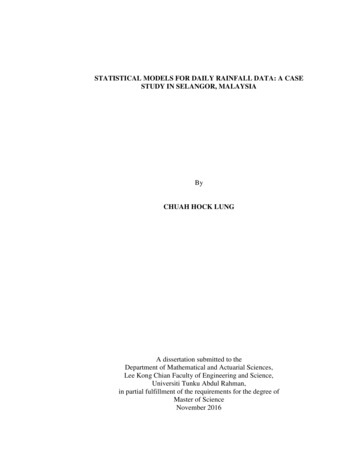
The revitalised FSR/FEH rainfall-runoff methodChapter 2 The Revitalised Flood Hydrograph(ReFH) model2.1 IntroductionRainfall-runoff modelling for design flood estimation has conventionally been based on themodelling of individual events. At the most rudimentary level all that is required to reproducethe catchment-scale relationship between storm rainfall and the corresponding stream flowresponse isz a volumetric loss to account for hydrological processes such as evaporation, soil moisturestorage, groundwater recharge and interception losses; andz a time distribution model to represent the various dynamic modes of catchmentresponse.However, the specification of the model developed to represent the rainfall-runoff relationshipis very much related to scale, both spatial and temporal. For instance, a model relating theannual rainfall and runoff for a small homogeneous catchment may be very simple, while therelationship between hourly rainfall and runoff on a large, heterogeneous catchment may beextremely complex. This ability to lump together various hydrological processes rather thanexplicitly include them and to identify and isolate the event response, together with thesimplicity of model application, accounts for the widespread use of the FSR/FEH approachto event-based modelling. The Revitalised Flood Hydrograph (ReFH) model has beendeveloped for use in the revitalised FSR/FEH rainfall-runoff method as a parameter-sparsehydrological model, representing the major rainfall-runoff processes on a catchment scale.In the following it is important to distinguish whether the ReFH model is used formodelling an observed flood event or for generating a design flood event. When modellingan observed event, the ReFH model is used as a deterministic model trying to reproduce aflood event from historical series of observed rainfall and soil moisture data. In contrast, adesign event is a probabilistic estimate of a flood event that will be exceeded on average onceevery T years, where T is the return period (e.g. T 100 years). When generating a design event(see Chapter 4), the input values of rainfall and antecedent soil moisture do not represent aparticular historic event but are generalised values specified so that certain combinations willresult in a flood event of the required return period.Figure 2.1 Schematic representation of the ReFH modelFLOOD ESTIMATION HANDBOOKSUPPLEMENTARY REPORT No.14FEHSR1body68gfcx2949.pmd49/14/2007, 4:56 PM
Revitalised Flood Hydrograph (ReFH) model2.2 Modelling conceptThe ReFH model consists of three main components: a loss model converting total rainfallinto effective rainfall, a routing model and a baseflow model. The connections between thethree model components are shown in Figure 2.1 together with the required input variablesand model parameters. In addition to the three main components, a soil moisture accountingmodel based on daily data is used to determine the state of the soil at the start of the floodevent based on long-term series of antecedent rainfall.When simulating a flood event, the loss model is used to estimate the fraction of thetotal rainfall volume turned into direct runoff. The direct runoff is then routed to the catchmentoutlet using the unit hydrograph convolution in the routing model and, finally, the baseflowis added to the direct runoff to obtain total runoff. Each of the three components, includingthe various model parameters, will be further explained further in the following sections.2.3 Loss modelThe loss model in ReFH is based on the Probability Distributed Model (PDM) developed byMoore (1985) and widely used for a variety of hydrological applications in the UK. The PDMmodel is being used in a framework for a national system for flood frequency estimation usingcontinuous simulation modelling in the UK (Lamb, 1999; Calver et al., 2005). Furthermore,the model has been used in real-time flood forecasting (Moore, 1999) and it has been used toinvestigate the impact of climate change on runoff from small catchments in the UK(Prudhomme et al., 2003).Conceptually, the PDM assumes the catchment to consist of a number of individualstorage elements, each of a random soil moisture capacity C arising from a statistical distribution.Assuming a uniform distribution of soil moisture capacities, if the storage elements arearranged in order from the highest (Cmax ) down to zero capacity, the resulting PDM distributionof soil moisture capacity is shown in Figure 2.2, where the horizontal axis represents thecumulative distribution. It is further assumed that the storage elements interact such that thesoil moisture is redistributed between stores between rainfall events. Thus, at any time soilmoisture is constant for all elements of capacity greater than Ct and is at full capacity forelements of capacity smaller than Ct as illustrated by the dark grey area in Figure 2.2. During astorm, the depth of water in each storage element is increased by rainfall (light grey area) andwhen rainfall exceeds the storage capacity, direct runoff is generated. For the short duration ofthe storms under consideration, the effects of evaporation and drainage out of the soils havenot been included.Figure 2.2 Equal water content Ct across stores of different capacity5FLOOD ESTIMATION HANDBOOKSUPPLEMENTARY REPORT No.1FEHSR1body68g.pmd59/24/2007, 2:14 PM
The revitalised FSR/FEH rainfall-runoff methodThus, a pulse of rain, Pt , on the soil gives 100% runoff from the area already at fullcapacity and increases the moisture content in all other areas. The excess amount of rainfallconverted into direct runoff, qt, can be estimated through simple geometric considerations asTW&W3W & PD[3W & PD[for t 1, 2, 3, (2.1)where the continuity equation Ct t Ct Pt applies and Cini is the soil moisture content atthe start of an event. The ratio q/P of rainfall transformed into direct runoff is a measure ofthe percentage runoff, and Cmax is the only model parameter. Once Ct exceeds Cmax , the modelassumes that 100% of the rainfall is converted into runoff. The derivation of Equation 2.1 isshown in Appendix A. The loss model can be applied sequentially, where a loss is calculatedfor each time step, or it can be applied to calculate a single loss of total rainfall volume. In therevitalised FSR/FEH rainfall-runoff method, the former option has been adopted, i.e. a lossis calculated for each individual time step. As the soil becomes increasingly wet during thestorm, the loss decreases and the runoff rate increases.The initial soil moisture content (Cini ) is an important parameter when applying theloss model, either for analysing an observed event or for simulating a design flood event. Themethod for obtaining an estimate of Cini is different for the two cases (observed or designflood event) and each case will be analysed in subsequent sections (observed event §3.2.6 anddesign event §4.5).2.4 Routing modelThe ReFH model uses the unit hydrograph (UH) concept for routing the net rainfall to thecatchment outlet (direct runoff). A UH can be estimated directly for each flood event throughsimultaneous analysis of the effective rainfall hyetograph and the direct runoff hydrograph asdescribed by Chow et al. (1988), for example. The original FSR/FEH model adopted a standardtriangular-shaped instantaneous unit hydrograph (IUH) scaled to each catchment using thetime-to-peak (Tp) parameter, catchment area and the selected time step. The ReFH modelretains the concept of a standard IUH shape scaled to individual catchments, but introducesa more flexible shape as shown in Figure 2.3 in the form of a kinked triangle.Figure 2.3 Shape of standard instantaneous unit hydrograph adopted in ReFHFLOOD ESTIMATION HANDBOOKSUPPLEMENTARY REPORT No.16FEHSR1body68gfcx2949.pmd69/14/2007, 4:57 PM
Revitalised Flood Hydrograph (ReFH) modelThe kinked triangle is described by a time scaling parameter, Tp, and two dimensionlessparameters, Up and Uk , controlling the height and kink, respectively, of the IUH. The parameterUk is a multiplier applied to the ordinate Uc of a non-kinked triangular IUH at 2Tp, i.e.Uc U pTBt 2TpTBt Tp(2.3)where TBt 2 Tp /Up to ensure unit-area under the non-kinked triangular unit hydrograph,illustrated by the broken line in Figure 2.3. Thus if Uk 1 the IUH is a simple triangle, but asUk drops towards zero, the ‘lost area’ is transferred into the IUH tail by extending the overalltime base TB.1 U p TB Tp 1 2U kU c (2.4)Attempts to relate the parameters controlling the height (Up ) and kink (Uk ) of the IUH toreadily available catchment descriptors were unsuccessful. Instead, average values of Up 0.65and Uk 0.8 are recommended for use in the revitalised FSR/FEH rainfall-runoff method.Because of the kink introduced at 2Tp the standard ReFH IUH has a lower peak and a longertime base than the FSR IUH. To convert the dimensionless IUH in Figure 2.3 into therequired units of m3 s–1 mm–1, a scaling factor of AREA / (3.6 Tp) is applied, where AREAis in km2 and Tp is in hours.The IUH can only be used directly when rainfall is given as a continuous function oftime. If rainfall is given as a sequence of depths in successive time steps t, the IUH mustfirst be converted to an equivalent t-hour UH. To transform the IUH in Figure 2.3 into aunit hydrograph of any given time step t, the ReFH model uses the S-curve method asdescribed in many standard hydrology textbooks such as Chow et al. (1988). The S-curvemethod replaces the existing FEH approximation of adding half the time step to the timeto-peak of the IUH. This approximation only works if t is a small component of Tp andthe unit hydrograph is not too skewed.An S-curve is a summation of the IUH and describes the flow resulting from imposinga continuous uniform-intensity storm on a catchment. The ordinates of the S-curve aredenoted by st . For an IUH, the S-curve at time t is obtained by integrating the IUH from timezero up to the considered time, i.e.ts t U (l )dl(2.5)0where U(t) are the ordinates of the IUH. Having obtained the S-curve for the IUH, the unithydrograph for a given time interval t is obtained by first offsetting the S-curve by a distance t thereby creating a new S-curve, s t' , wheres t' s t t(2.6)The difference between the two S-curves divided by the offset period, t, gives the unit'hydrograph, u t of the desired time period, i.e.ut' 1(st st t ) t(2.7)In practice, this equation is equivalent to defining the unit hydrograph at the nth time step(time n t ) as the volume under the IUH between t – t and t as seen by combining Equations2.5 to Equation 2.7:t tt t 1(st s t t ) 1 U (l )dl U (l )dl 1 U (l )dl t t 0 t t t0(2.8)7FLOOD ESTIMATION HANDBOOKSUPPLEMENTARY REPORT No.1FEHSR1body68g.pmd78/16/2007, 4:29 PM
The revitalised FSR/FEH rainfall-runoff methodHaving estimated the t-hour UH, the routing of the net rainfall to the catchment outlet iscarried out using the convolution equation:tqt Pi u t i 1i 1fort 1, 2, 3, (2.9)where qt denotes the t th ordinate of the rapid response runoff hydrograph, Pi the i th effectiverainfall and ut the t th ordinate of the t-hour unit hydrograph.2.5 Baseflow modelThe baseflow model implemented in the ReFH model is based on the linear reservoir concept,with a characteristic recession defined as an exponential decay. The approach, discussed byAppleby (1974) allows the separation of total flow in baseflow and surface flow withoutknowing the rainfall input. It is based on the contributing area concept, and assumes that thesaturated area of the catchment that produces surface runoff is the same area that also producesbaseflow recharge, and furthermore that the ratio of recharge to runoff, BR, is fixed. Anunsaturated area produces neither runoff nor recharge because rainfall is retained as soil moisture.Rainfall that becomes recharge is assumed to pass through a linear storage (with a lag value ofBL) before emerging into the same channel system that carries the surface runoff. The baseflowhydrograph at the catchment outlet can be determined by routing BR times the (as yet undefined)surface flow at the outlet through the groundwater store. The observed hydrograph at theoutlet is then the sum of the surface and baseflow hydrographs.The resulting baseflow model calculates the baseflow at successive time steps t apartby linking the baseflow to the observed runoff and the estimated baseflow from the previoustime step asz t t k1Qt k 2 Qt t k 3 z t(2.10)where Qt is total observed flow at time t. For the case where the baseflow model is being usedto analyse an observed flood event, the constants k1, k2 and k3 are given ask1 k2 BR BL (1 k 3 ) k3 1 BR (1 BR ) t(2.11)BR BL (1 k 3 ) 1 1 BR t 1 BR (2.12) t(1 BR ) k 3 exp BL (2.13)Thus, successive points along the baseflow hydrograph can be determined from the modelparameters BR and BL, a starting baseflow BF0 z0 (before the event) and the obs
The CEH project team wishes to acknowledge the following people and organisations for assistance provided during the project: The National Water Archive, the British Atmospheric Data Centre, the Environment Agency and the Scottish Environment Protection Agency for providing the rainfall data used in this study;