Transcription
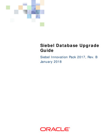
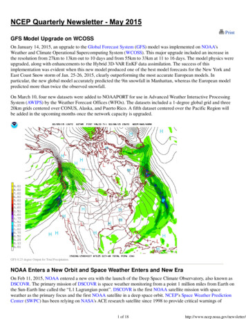
PrintGFS Model Upgrade on WCOSSOn January 14, 2015, an upgrade to the Global Forecast System (GFS) model was implemented on NOAA'sWeather and Climate Operational Supercomputing System (WCOSS). This major upgrade included an increase inthe resolution from 27km to 13km out to 10 days and from 55km to 33km at 11 to 16 days. The model physics wereupgraded, along with enhancements to the Hybrid 3D-VAR EnKF data assimilation. The success of thisimplementation was evident when this new model produced one of the best model forecasts for the New York andEast Coast Snow storm of Jan. 25-26, 2015, clearly outperforming the most accurate European models. Inparticular, the new global model accurately predicted the 9in snowfall in Manhattan, whereas the European modelpredicted more than twice the observed snowfall.On March 10, four new datasets were added to NOAAPORT for use in Advanced Weather Interactive ProcessingSystem (AWIPS) by the Weather Forecast Offices (WFOs). The datasets included a 1-degree global grid and three20km grids centered over CONUS, Alaska, and Puerto Rico. A fifth dataset centered over the Pacific Region willbe added in the upcoming months once the network capacity is upgraded.GFS 0.25 degree Output for Total Precipitation.NOAA Enters a New Orbit and Space Weather Enters and New EraOn Feb 11, 2015, NOAA entered a new era with the launch of the Deep Space Climate Observatory, also known asDSCOVR. The primary mission of DSCOVR is space weather monitoring from a point 1 million miles from Earth onthe Sun-Earth line called the “L1 Lagrangian point”. DSCOVR is the first NOAA satellite mission with spaceweather as the primary focus and the first NOAA satellite in a deep space orbit. NCEP's Space Weather PredictionCenter (SWPC) has been relying on NASA's ACE research satellite since 1998 to provide critical warnings of1 of 18http://www.ncep.noaa.gov/newsletter/
approaching solar storms. DSCOVR will now be serving this role, providing 15-60 minutes warning of approachingsolar wind streams and storms that cause geomagnetic storms. Geomagnetic storms impact the nation's powerindustry by causing large-scale DC currents in high-voltage transmission lines. Geomagnetic storms also causeEarth's Van Allen radiation belts to be disrupted, creating potentially hazardous conditions for satellites in Earth'sorbit. Earth's ionosphere is affected as well, creating problems for GPS/GNSS users, particularly users of precisionGPS and the FAA's Wide Area Augmentation System (WAAS) that aids commercial aviation navigation. Largersolar and geomagnetic storms can also increase radiation levels at commercial aviation altitudes making warningsfrom DSCOVR a critical safety function of the SWPC. And while they can negatively impact many of our criticalinfrastructure systems, solar storms can also bring beautiful aurora down to latitudes where they can be seen fromthe United States. NCEP's SWPC will use DSCOVR to provide highly accurate warnings of incoming solar stormsand imminent geomagnetic disturbances to this broad swath of customers. Providing these warnings allows ourcustomers to take mitigating action to protect people and critical infrastructure from harm.DSCOVR was made possible by a joint program between NOAA, NASA, and the US Air Force. NASA provided thespacecraft, the Air Force provided the SpaceX Falcon-9 launch, and NOAA will operate DSCOVR as the firstoperational space weather satellite in deep space. DSCOVR will complete its journey to the L1 point on June 8.Following instrument checkout, NASA will transition DSCOVR to NOAA to begin its formal operational period inmid-July.2 of 18http://www.ncep.noaa.gov/newsletter/
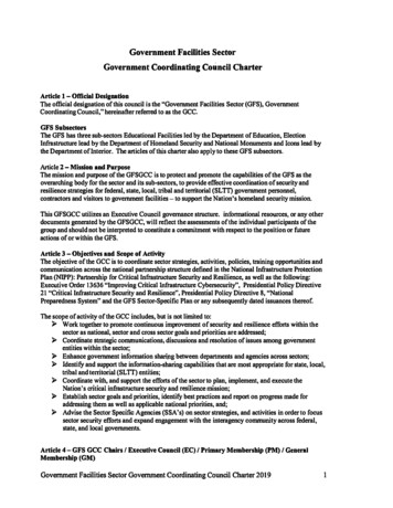
Image of the Falcon-9 rocket that carried DSCOVR into orbit just after ignition of the engines.A view of the nozzle of the second stage of the Falcon-9 with a view of the gibbous Earth.Both images courtesy of SpaceX. These images come from the SpaceX Flickr page and are labeled as Public /with/16673034486/)Operational Demonstration of a New Collaborative Aviation Weather StatementOn March 3, 2015, the Aviation Weather Center (AWC) began an operational demonstration of a new continuouscollaborative process called Operational Bridging (OB) and a resultant product, the Collaborative Aviation WeatherStatement (CAWS). National Weather Service (NWS) meteorologists, airline meteorologists, and other airline andFederal Aviation Administration (FAA) personnel, collaborate throughout the day using NWSChat. Thiscollaboration results in specific, high-impact, thunderstorm event forecasts focused on the United States’ majorairports and high traffic, sensitive regions. The CAWS replaces the collaborative component of the CollaborativeConvective Forecast Product (CCFP), which has been replaced by an objectively generated product during thedemonstration. The CAWS supports the identification of National Airspace System (NAS) constraints due tothunderstorms that impact strategic NAS planning. It supports the FAA and the airline’s ability to more effectivelyinitiate, adjust, or terminate planned or active Traffic Management Initiatives (TMI), to balance traffic demand inthe constraint locations resulting in more efficient use of available airspace. The expected benefits to the aviationcommunity should be a reduction in fuel costs and expenses associated with flight delays, cancellations, anddiversions, due to timely adjustments to the forecast weather and more efficient TMI management.The FAA, pursuant to Title 49 United States Code Section 44720, established requirements for this weatherinformation and service which is necessary for the safe and efficient conduct of operations in the NAS. The initialFAA requirements focus on convective weather, since convection has historically caused the greatest number ofNAS constraints. If proven successful, the OB/CAWS is planned to be expanded to all aviation hazards. During theoperational demonstration of OB/CAWS which will be conducted throughout the 2015 convective season the FAAwill lead an assessment to refine CAWS requirements. During the evaluation, input focusing on usability,effectiveness, and areas of potential improvement for OB and the CAWS, will be collected.Public comments will be collected via a survey de CCFPGThe current CAWS product may be found online at3 of 18http://www.ncep.noaa.gov/newsletter/
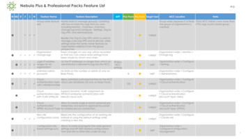
orative Aviation Weather Statement issued on April 9, 2015, for thunderstorms impacting Chicago and high traffic areas over Ohio and Pennsylvania.Collaborative Aviation Weather Statement issued on April 9, 2015, for thunderstorms impacting Chicago and high traffic areas over Ohio and Pennsylvania.Unprecedented Winter Weather CollaborationThe winter of 2015-16 was unrelenting in the northeast U.S. Boston. It set an all-time snowfall record and numerouslow temperature records across the east. The Weather Prediction Center took a leadership role in the integratedfield structure for this national weather extreme. WPC provided an unprecedented level of field unit collaborationand WPC was involved with 41 multi-office collaboration calls, among 143 participants in every part of the UnitedStates.4 of 18http://www.ncep.noaa.gov/newsletter/
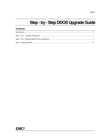
At the same time as providing unprecedented collaboration internally, WPC extended capability to conduct 156media interviews just in February, with 115 of them being radio interviews and 41 print news. Frequent interviewsincluded Bloomberg News, Reuters, CBS, and the Associated Press. The enhanced national media attentionestablished NWS as the nation's trusted source for weather information and is critical for appropriate publicresponse during threatening weather.Two storms particularly stand out, the first being the pre-Thanksgiving storm of 2014. This was a difficult forecastwith potential high impact on major metropolitan areas during the busiest travel days of the year. Awareness wasraised up to 7 days in advance with the WPC Medium Range forecasts. As the event drew closer, collaboration callswere held between WPC and local forecast offices. Forecasters emphasized it would be a close call for the bigcities, with the heaviest snow just to the west. The forecast snowfall amounts were used to make Warning andAdvisory decisions which were very accurate (Fig. 1). NWS Director Dr. Uccellini commented, "I was more thanimpressed with how NCEP and Eastern Region worked the collaborative effort to bring about the coherent forecastand communication of the evolution of this event."Second was the blizzard of January 25-27, 2015, which set an all-time record snowfall in Worster, MA, whileproducing over a foot of snow from New York to Portland, ME. Amazingly, the potential for a coastal storm waspredicted seven days in advance, with the specific threat to the Northeast highlighted consistently up to five days inadvance. Special collaboration calls among WPC and northeast forecast offices yielded a consistent picture ofheavy snow from New Jersey to Maine, even in the face of model uncertainty 24-36 hours in advance of the storm.Attendant national media interviews sent a consistent message of a major event. For the event as a whole, thewinter storm warning accuracy was 98% with an amazing 37 hour lead time – well above typical performance. Theresult of the accurate, consistent, and understandable message, in this case, was appropriate preparations and aquick recovery throughout the region.The unprecedented collaboration and intense media messaging is building a Weather Ready Nation.Example of the WPC deterministic snowfall forecast and the associated Warnings and Advisories (insert) issued by local forecast offices for the pre-Thanksgiving storm of 2014.NOAA's Weather and Climate Operational Supercomputing System: A StatusReportOn February 18, 2015, The WCOSS Phase II upgrade was formally accepted by NOAA's Contracting Officer. IBMdelivered 1,080 additional compute nodes and 2 petabytes of additional storage for WCOSS. With the addition ofPhase II, the total capacity of WCOSS has increased from 213 Teraflops (TF) (peak) to 776 TF (peak). On the dayafter formal acceptance, the operational High-Resolution Rapid Refresh (HRRR) model was moved onto the Phase2 nodes. The NCEP Production Suite now runs across the integrated Phase 1 and Phase 2 systems.5 of 18http://www.ncep.noaa.gov/newsletter/
On February 15, task order 005 was awarded. This task order separated the cost and billing for the electrical powerand cooling from task orders 002, 003, and 004. The expectation is that NCEP should realize some cost savingsover time. A contract modification was made to task Order 002 adding additional storage hardware and software toimprove the overall performance of the storage architecture delivered as part to task orders 002 and 003.On February 27, the contract award for task Order 004 was completed, adding 2 Petaflops (PF) of additionalcompute capacity, providing a total of 2.8 PF for the entire WCOSS, per site. Equipment delivery will begin in June2015 with system acceptance planned to be completed by October 2015.Picture of WCOSS Gyre (Phases 1 and 2) located in Orlando, Florida.National Hurricane Conference Takes Place in AustinThe 37th annual National Hurricane Conference took place in Austin, Texas, from March 30 to April 2, 2015.Throughout the four-day program, NHC hurricane specialists joined with experts from other federal agencies,academia, and emergency management, to conduct and participate in workshops and panel discussions regardingtropical cyclones. The primary goal of the conference was to improve hurricane preparedness, response, recovery,and mitigation, in order to save lives and property in the United States and the tropical islands of the Caribbean andPacific. In addition, the conference served as a national forum for federal, state, and local officials, to exchangeideas and recommend new policies to improve Emergency Management. There were nearly 100 panel discussionsthat dealt with the above goals.There were more than three dozen media interviews conducted over the span of the conference, arranged andfacilitated by NOAA/NHC Communications PAO Dennis Feltgen. In addition, a press conference was conductedwith NHC Director Rick Knabb and FEMA Administrator Craig Fugate, also facilitated by Feltgen.The principle themes were:1) Focus on the hazards of the tropical cyclone, not just the category of intensity.2) The prototype storm surge watch/warning graphic will debut this season.3) The potential storm surge flooding map will continue experimentally this season.4) The seasonal outlook should never be used as a guide to preparation.The main interviewees were NHC Director Rick Knabb, Hurricane Specialist Unit Branch Chief James Franklin,NHC Storm Surge team leader Jamie Rhome, Science and Operations Officer Chris Landsea, and the HurricaneSpecialists. They were interviewed primarily by the print and television media with stations along the gulf andsoutheast coasts.6 of 18http://www.ncep.noaa.gov/newsletter/
Former NHC Director Bill Read, now a consultant to a Houston TV station, interviews current NHC Director Dr. Rick Knabb at the National Hurricane Conference.Space Weather at NOAA Satellite Science WeekThe Space Weather Prediction Center (SWPC) provided several talks in support of the space weather session atNOAA's Satellite Science Week meeting. The meeting was held in Boulder, Colorado the week of February 23,2015, and covered a wide range of topics with the intention of discussing the state of the science portfolios of theGOES-R and JPSS programs.Dr. Tom Berger, SWPC Director, gave the Space Weather session keynote, which provided the audience anexcellent overview of space weather and the way satellite and ground data are used in nowcast and forecast. Dr.Steve Hill then gave a talk on the progress of migrating to AWIPS 2 and how present and future GOES data is beingintegrated with the support of NCO. Dr. Rodney Viereck provided updates on the major ongoing efforts in theSpace Weather Prediction Testbed (SWPT) at SWPC, including the Whole Atmosphere Model, GeospaceModeling, and the WSA-Enlil solar wind model. Dr. Terry Onsager spoke about international coordination on spaceweather, to include the following: WMO (World Meteorological Organization), ICAO (International Civil AviationOrganization), CGMS (Coordination Group for Meteorological Satellites), COPUOS (United Nations Committee onthe Peaceful Uses of Outer Space) and ISES (International Space Environment Service). Additional supporting talkswere given by Bill Denig (NESDIS) and Dr. Greg Kopp (University of Colorado).The Space Weather session presentations provided an introduction to those in the audience with terrestrial weatherbackgrounds and depth to help inform decision makers within the NOAA satellite community.7 of 18http://www.ncep.noaa.gov/newsletter/
Group picture of participants at NOAA's Satellite Science Week meeting.Operational Implementation of the Helicopter Emergency Medical Services (HEMS)ToolThe Aviation Weather Center (AWC) will commence operational production of the Helicopter Emergency MedicalServices (HEMS) Tool on May 4th, 2015. The operational implementation follows a public comment period, inwhich all responses were positive. In reference to the HEMS Tool, one user stated, "It is always up on a large screenin our Air Medical Communications Center and we check it before every flight request is given to our pilots."HEMS operates in a demanding environment. They give an invaluable service to the public by providing crucial,safe, and efficient transportation of critically ill and injured patients to medical care facilities. While thecontribution of HEMS is a profound component of the nation's medical infrastructure from an operationalstandpoint, it is a commercial aviation activity performed by Federal Aviation Administration (FAA) certificated aircarrier operators. As such, operations must have the highest level of safety. The HEMS Tool is designed to provide aone-stop shop for weather information pertinent to the low-level, short-duration flights common among the HEMScommunity. By using a highly interactive and intuitive tool that focuses on small, localized regions, HEMS operatorsgain critical weather awareness to make their flights safer for crews and patients.The HEMS Tool can overlay multiple fields of high resolution grids of critical weather parameters: ceiling, visibility,flight category, winds, relative humidity, temperature, icing severity, satellite, radar, G-AIRMETs, SIGMETs,METARs, TAFs, and PIREPs. All 3D data is interpolated to AGL altitudes and can be sliced horizontally on 1000ft. intervals, up to 5000 ft. All data is time synchronized to go back, up to 6 hours and forward, up to 6 hours. Thetool has high-resolution ESRI basemaps, including colored-relief and satellite. The user can also display navigationalaids, airports, and heliports, for the entire United States. More detail is revealed as the user zooms in on the display.The HEMS Tool may be found online at https://aviationweather.gov/hemst.8 of 18http://www.ncep.noaa.gov/newsletter/
Screen capture of the HEMS Tool display.Senator Mikulski Visits NHCNHC hosted a visit by U.S. Senator Barbara Mikulski (D-Maryland) on April 9th, 2015. After meeting with NHC'sbranch chiefs, the Senator toured the hurricane operations area, the FEMA/NOAA Hurricane Liaison Team office,and CARCAH (Air Force hurricane hunters liaison). Our thanks to the Senator for her continued support.The purpose of the visit was familiarization, as this was her first visit to NHC. NHC's branch chiefs, storm surgeteam lead, public affairs officer and Miami MIC helped the NHC deputy director host the Senator and her stafferJean Toal-Eisen. The Senator was very engaged (and engaging) and perceptive. She praised NOAA/NWS from thestart and took pride in helping move NCEP to its new facility. After an overview briefing, we took a walking tourthrough the NHC hurricane operations area, FEMA/NOAA Hurricane Liaison Team office (briefing by FEMA'sHLT member), and CARCAH (Air Force hurricane hunters liaison) area as presented by that unit's chief. TheSenator expressed interest in knowing what it takes to improve hurricane forecasting.The Senator made it clear she still has two more years where she can be a factor. We discussed the importance ofobservations, the models, and how they, along with increasing computational capabilities, are what have driven usto better forecasts, especially for track. We shared with her the challenges of intensity forecasting and highlightedthe promise of the Hurricane Forecast Improvement Project. We touched on the Joint Hurricane Testbed, about therole of weather satellites, and the importance of real-time communication, as well as the training we provide andour outreach and education program.We were prepared for her questions about Hurricanes Katrina, Isabel (including her own experience) and Sandy(the impact for her area). We had an extended discussion about our work on storm surge and fielded questions sheasked about the effect of sequestration and how the Sandy Supplemental has benefited us.9 of 18http://www.ncep.noaa.gov/newsletter/
U.S. Senator Barbara Mikulski discusses a dropwindsonde instrument with CARCAH chief John Pavone.U.S. Senator Barbara Mikulski standing in front of a display showing a hurricane event.Tall Ships America ConferenceActing Ocean Prediction Center (OPC) Director Joseph Sienkiewicz participated in the annual Tall Ships AmericaConference in Philadelphia. The main conference was held February 4-6, and the Practical Weather Workshop washeld February 7-8. Tall ships events are excellent outreach opportunities for OPC because the attendees appreciatethe work done by OPC and the National Weather Service (NWS) for the maritime community. They understand thechallenges of the industry and are an important part of the international weather services network. The vessels inthe tall ship community are slow moving, extremely weather sensitive, and, most importantly, carry students ascargo. The loss S/V Concordia in 2012 and Bounty in Hurricane Sandy (2012) still ring clear in this community; tallships sailors continue to make marine weather information a key topic during their national and internationalconferences.For Mr. Sienkiewicz's session talk, he described the evolution of a North Pacific extratropical cyclone andhighlighted the predictive capabilities that OPC routinely sees in forecast operations. The instructive session wasattended by approximately half of the conference attendees.In preparation for hosting the Practical Weather Workshop, Mr. Sienkiewicz worked with Captain Rick Miller of theMaine Maritime and Sea Education Association and Captain Jonathan Kabak of the United States Merchant MarineAcademy, to assemble an agenda appropriate for a wide spectrum of traditional vessel sailors. There wereapproximately 30 students for the two workshops. Participants ranged from trainees to some of the most seasonedcaptains from United States vessels. Mr. Sienkiewicz led exercises designed to help solidify the instructional goalsand to clarify a variety of text and graphical products the OPC and National Hurricane Center (NHC) produce. Theworkshop was held in the Independence Seaport Museum at Penns Landing on the Delaware River in Philadelphia.10 of 18http://www.ncep.noaa.gov/newsletter/
Acting OPC Director Joseph Sienkiewicz leading marine weather tutorials during the Tall Ships America Conference.Penns Landing with Dewey’s Flagship Olympia, Philadelphia.Climate Prediction Center Issues El Nino AdvisoryThe Climate Prediction Center (CPC) upgraded the previously issued El Niño Watch to an El Niño Advisory onMarch 5, 2015. Above-average sea surface temperatures (SSTs) across the western and central Pacific, which hadbeen observed since late 2014, became weakly coupled to the tropical atmosphere. The advisory was continued inApril, with forecasters stating that odds are roughly 70% that El Niño conditions will persistent though summer andabove 60% that they will last through the fall. This forecast relies on current observations, including a substantialsupply of warmer-than-average subsurface waters in the equatorial Pacific. In addition, most of the dynamicalmodels predict continued equatorial Pacific surface temperature anomalies above 0.5 . With the exception of onemodel, the forecasts are closely grouped, indicating they are fairly confident in the forecast. However, in spring2014 the dynamical climate models were also confident that we were headed for a significant El Niño in the secondhalf of 2014, which did not materialize. In addition, models historically have a harder time making successfulforecasts for El Niño during the spring, known as the “spring predictability barrier”.11 of 18http://www.ncep.noaa.gov/newsletter/
The late start, combined with the weak conditions, implies that El Niño is unlikely to exert significant impactsoutside of the Tropics for the next few months. For example, historical precipitation patterns associated with ElNiño show that only about 3 of the past 10 El Niño years exhibited above-average rainfall in California duringMarch-April-May. Another way of looking at the historical relationships shows that ENSO has very little correlationto precipitation over North America during the spring or summer. Historically, El Niño is generally associated withsuppressed tropical cyclone activity in the Atlantic and enhanced activity in the Eastern Pacific. However, El Niñois only one factor, and the CPC will release its forecasts for the 2015 North Atlantic and Eastern Pacific HurricaneSeasons on May s monitoring/enso advisory/ensodisc.htmlAverage sea surface temperature (SST) anomalies ( C) for the week centered on 1 April 2015. Anomalies are computed with respect to the 1981-2010 base period weekly means.5th Annual HMT-WPC Winter Weather ExperimentFrom January 12th to February 13, 2015, the HydroMeteorology Testbed-Weather Prediction Center (HMT-WPC)hosted its annual Winter Weather Experiment. Now in the fifth year, the experiment brought together 28forecasters, researchers, and model developers, from across the weather enterprise to conduct exercises aimed atcontinuing improvement of winter weather forecasts. Additionally, this year's experiment featured a daily webinar,where participants shared their forecast thoughts and discussed experimental model data with remote participantsacross the National Weather Service (NWS).One focus of the experiment was the continued exploration of model micro-physics based snowfall forecastingmethods. The idea is to use the explicit information coming from the model microphysics instead of makingassumptions and using algorithms based on temperature and humidity to derive the snow amounts. Currentalgorithms are prone to error and are not necessarily what the model is actually predicting. Fig. 1 shows two new,different approaches using the amount of riming on hydrometeors and percent frozen precipitation applied to theNorth American Model (NAM) forecasts for the Jan 27-28 northeast U.S. Blizzard. These new approaches werefound to be helpful in making snowfall forecasts, particularly in rain-to-snow transition zones. The testbed willcontinue to work with the Environmental Modeling Center (EMC) and others to implement these new approachesin operations, as well as expand to other modeling systems.A second focus was expanding medium range probabilistic winter weather forecasts to include forecasts of heavysnow and freezing rain from Days 4-7. The experiment found that Day 4-7 probabilistic winter weather guidance12 of 18http://www.ncep.noaa.gov/newsletter/
was well received. Objective verification of the lower threshold of the probability of 1" showed positiveprobabilistic skill through Day 7. However, higher thresholds were not as skillful and more work is required. Thus,the Day 4-7 probabilistic winter weather outlook will use the 1" threshold and be a public experimental product forthe 2015-16 season.Figure 1. Comparison of two different new approaches using explicit microphysical information from the NAM model from forecasts of the Jan 26-27 northeast U.S. Blizzard.MADIS Operational on NOAA's Integrated Dissemination Program (IDP) SystemOn January 21, 2015, the Meteorological Assimilation Data Ingest System (MADIS) running on NOAA's IntegratedDissemination Program (IDP) system in College Park, MD, became operational. This came after many years ofdevelopment by NOAA's Global Systems Division (GSD) of the Earth System Research Laboratory (ESRL), and acommitment from GSD and National Weather Service (NWS) to complete the research-to-operations process forMADIS.The MADIS system ingests data from NOAA data sources and non-NOAA providers, decodes data then encodes allof the observational data into a common format with uniform observational units and time stamps. Quality control(QC) checks are conducted and the integrated data sets are stored along with a series of flags indicating the resultsof the various QC checks. MADIS provides several methods for users to access the data to meet their needs. Userscan request data from July of 2001, which is when MADIS was first available to the public, to present.The NWS Initial Operational Capability (IOC) MADIS on Weather and Climate Operational SupercomputingSystem (WCOSS) was decommissioned on April 1. The operational instance of MADIS on WCOSS was turned offResearch to Operations (R2O) process will continue for MADIS as users are transitioned to the operational servers.This will be finalized when GSD can turn off their servers at the end of May 2015.13 of 18http://www.ncep.noaa.gov/newsletter/
Figure above depicts the data ingest, processing, and distribution components, of the system.NHC Trains Emergency ManagersDuring the hurricane off-season months, NHC plays a key role in the training of emergency managers and decisionmakers in the use of NHC products. In just the first two months of this year, NHC hosted five week-long trainingsessions. This includes three FEMA L-0324 courses - "Hurricane Preparedness for Decision Makers", the first everWorld Meteorological Organization Region IV International Storm Surge Workshop, and the NWS EffectiveMessaging Workshop.The emergency managers and decision makers are local and state employees from the Gulf, Southeast, andNortheast United States coasts. The three FEMA L-0324 courses are conducted for emergency managers from eachof those regions and the subject matter is tailored for each region. Several FEMA regional or national headquarteremployees also participated. The classes are technically run by FEMA's Emergency Management Institute andfunding is through FEMA's National Hurricane Program. Instructors include NHC Hurricane Specialists, FEMAregional hurricane program managers, and U.S. Army Corps of Engineer (USACE) personnel.The participants learned about the tools available to make better evacuation decisions during tropical cyclonethreats. They also learned about the dangers of storm surge and why they need to evacuate residents from coastalcommunities that are at risk of inundation from storm surge. The students gained an understanding of NHC forecastproducts, the hurricane evacuation study process, and about the Hurricane Evacuation (HURREVAC) decisionsupport tool.The overall objectives of the course have changed little from year to year, but the course has become morehands-on the past 5 to 10 years. Students are shown how the NHC makes tropical cyclone forecasts with severalbreakout sessions conducted to help them learn about NHC products, the hurricane evacuation study process, andhands-on time with the tools av
the constraint locations resulting in more efficient use of available airspace. The expected benefits to the aviation community should be a reduction in fuel costs and expenses associated with flight delays, cancellations, and diversions, due to timely adjustments to the forecast weather and more efficient TMI management.