Transcription
KITSAP COUNTY ROAD STANDARDS 2017Chapter 1Introduction1.1Authority and IntentChapter 36.75 RCW requires that County roads be established, laid out, constructed, altered, repaired, improved, and maintained bythe County or by private individuals or entities authorized to perform such work under an agreement with the County legislativeauthority. Such work and improvements shall be done in accordance with adopted County standards under the supervision anddirection of the County Engineer.These Kitsap County Road Standards have been authorized by the Kitsap County Board of Commissioners to govern the design andconstruction of publicly maintained roadways within existing County right of way or roadways on private property that are to bededicated to Kitsap County for right of way.These Standards were developed to provide minimum design requirements for the safety, welfare, and convenience of the travelingpublic. They are intended to assist, but not substitute for competent work by design professionals. It is expected that land surveyors,engineers, and architects bring to each project, their best skills from their respective disciplines. Application of minimum requirementsdoes not take the place of sound engineering practice. Project Engineers designing road improvements under these standards shouldtake into account all available information and use professional judgment based on training and experience to make final designdeterminations. Acceptance of plans by the County does not relieve the proponent or engineer from responsibility for ensuring that thedesign, specifications, and construction comply with current engineering standards and applicable federal and state laws and codes.These Standards are not intended to represent the legal standard by which the County's duty to the traveling public is measured. TheseStandards are not intended to limit any reasonable innovative or creative effort that improves quality or reduces costs or potentialenvironmental impacts. Any proposed departure from these Standards shall be judged on the likelihood that it shall produce acompensatory or comparable result, in every way adequate for County road users and residents and without significant reduction inlevel of service, safety, or operational efficiency.Kitsap County encourages the use of low impact development techniques that minimize impervious surfaces, loss of native vegetationand runoff generation associated with development. The County Engineer may support deviations from adopted standards when lowimpact development techniques are employed without risk to the traveling public, critical infrastructure, or maintenance operations.1
These Standards are intended to encourage standardization of road design elements and to help meet the public safety needs ofmotorists, bicyclists, and pedestrians. They address safety, convenience, appearance, stormwater management, economicalmaintenance, and requirements for the installation of utilities within transportation rights of way.Shortened Designation: These Kitsap County Road Standards shall be cited routinely in the text as the “Standards.”1.2ApplicationThe Kitsap County Road Standards apply to all designed and newly constructed or reconstructed public roads and trails within KitsapCounty rights of way or within private property to be dedicated to Kitsap County for right of way by any person, firm, corporation or otherentity. They do not apply to roads in existence prior to the adoption of these Standards. The Standards are not intended to apply togeneral maintenance activities performed on roads.Land development activity that shall impact the level of service, safety, or operational efficiency of existing roads or that is required byother County Code or ordinance to improve such roads, may be required to provide improvements in accordance with these Standards.The need for off-site improvements to existing County roads shall be based on an assessment of the potential impacts of the proposal.These Standards apply to the design and construction of public roads both by Kitsap County and the private development community.These Standards are not intended to govern the construction of privately maintained roads that are located outside County rights ofway. It is however, recommended that designers of such roads adhere to these standards.1.3Associated Regulations and SpecificationsAll road plans submitted to the County for review and approval shall be consistent with these Standards and current or amendedCounty standards and ordinances, and Kitsap County Code.Stormwater management requirements associated with road improvements shall comply with the requirements of the Kitsap CountyCode Title 12, as it now exists or is hereafter amended. This document does not establish or supersede any of the requirementsestablished in the Kitsap County Code Title 12 Stormwater Drainage, or other pertinent regulatory requirements. The Project Engineermust observe all other applicable regulations and design standards.The most current edition as amended of the following publications and manuals shall be applicable when specifically cited in theStandards or when required by state or federal funding authorities.2
A. A Policy on Geometric Design of Highways and Streets, (Green Book) published by the American Association of State Highway andTransportation Officials (AASHTO).B. Standard Specifications for Road, Bridge and Municipal Construction, published by the Washington State Department ofTransportation (WSDOT) and American Public Works Association (APWA).C. Standard Plans for Road, Bridge and Municipal Construction, published by WSDOT.D. Design Manual, published by WSDOT.E. Local Agency Guidelines, published by WSDOT.F. Guidelines for Geometric Design of Very Low-Volume Local Roads (ADT less than or equal to 400), published by the AmericanAssociation of State Highway and Transportation Officials (AASHTO).G. Roadside Design Guide, published by AASHTO.H. Manual on Uniform Traffic Control Devices, (MUTCD) published by the U.S. Department of Transportation, Federal HighwayAdministration, as amended and approved by WSDOT.I. Construction Manual, published by WSDOT.J. Guide for the Development of Bicycle Facilities, adopted by AASHTO.K.Guide for the Planning, Design, and Operation of Pedestrian Facilities, AASHTOL. Traffic Manual, as published by WSDOT.M. Highway Capacity Manual, published by Transportation Research BoardN. ITE Trip Generation Manual, published by Institute of Transportation EngineersO. Bridge Design Manual, published by WSDOT.3
1.4Design Approval and Technical Deviation ProcedureIt is the intent of these design standards to allow the design professional maximum latitude in the geometric design of roadways withinthe County while keeping within the realm of acceptable design practice. In order to provide this latitude, it is recognized that there is acertain amount of discretion inherent in implementing these standards. The County Engineer shall make the final determination of theadequacy of the design parameters and standards employed on a particular project.In the event that representatives for a private development project disagree with a determination by the County Engineer, or wish torequest a deviation from these Standards, they may do so by submitting to the County Engineer a Request For Technical Deviation.The Request for Technical Deviation shall at a minimum :(1) Be in writing and state the nature of the request,(2) State why the deviation is necessary and identify any adverse impacts,(3) Include supporting drawings and calculations demonstrating how the request meets the intent of the Road Standards,(4) Reference resource materials pertinent to the request and other supporting documents,(5) shall include an engineering analysis of the alternatives,(6) Be signed and sealed by a Washington State licensed professional engineerThe County Engineer may allow less requirements for non-engineering minor deviation requests.The County Engineer shall evaluate the request for deviation on these criteria:(1) The technical deviation shall not otherwise result in non-compliance with the Road Standards Ordinance or any otherapplicable code;(2) The granting of the technical deviation shall not result in non-compliance with development conditions imposed upon aproject by the Department of Community Development, the Hearing Examiner and/or Board of Commissioners;(3) The granting of the technical deviation shall produce a compensating or comparable result that is in the public interest, and;(4) The granting of the technical deviation shall meet the objectives of safety, function, appearance, environmental protectionand maintainability based on sound engineering judgment.Within twenty (20) calendar days of the receipt of the Request for Technical Deviation, the County Engineer shall, in writing, accept,deny, or accept with conditions the request. If the request is denied, the County Engineer shall state the reasons for the denial. Anaggrieved party may appeal any administrative interpretation or departmental ruling related to the Standards by following the process4
set forth in Kitsap County Code, Title 21.04, as it now exists or is hereafter amended.1.5PermitsNo person, firm, partnership, association, joint venture, corporation, or other public or private legal entity shall conduct any constructionactivity within County right of way unless the work is in accordance with a valid “Permit to Perform Work in County Right of Way”. Toobtain a permit, the applicant shall submit an application to the Department of Public Works. The application submittal shall include acopy of the construction plans, meeting all applicable requirements.A copy of each “Permit to Perform Work in County Right of Way” shall be available for inspection at the construction site for the durationof the work.1.6 FeesFees required under this Ordinance and/or the Road Standards are as specified in the Kitsap County Development Permit FeeSchedule, Kitsap County Code Section 21.06.100, as it now exists or is hereafter amended.1.7Definitions"Applicant" shall mean any person, firm, partnership, association, joint venture, corporation, or other public or private legal entity thatproposes to engage in any construction activities within County rights of way."Approach" shall mean a connection providing private vehicular access to or from the County road system. (see “Driveway” and “RoadApproach”)“Arterial Roads” shall mean roads within Kitsap County that have been classified using the federally designated functional classsystem. This system is used by the federal government to distribute transportation funds to local agencies. Arterial roads are typicallyintended to provide mobility while controlling direct access. Examples of arterials are Silverdale Way (Principal Arterial), Mile Hill Drive(Minor Arterial), and Hood Canal Drive (Collector Arterial)."Auxiliary Lane" shall mean the portion of the roadway adjoining the traveled way for parking, speed change, truck climbing, turning orother purposes supplementary to through-traffic movement, but shall not mean shoulder.5
"Average Daily Traffic (ADT)" shall mean the volume of traffic passing a point or segment of a road, in both directions, during a periodof time, divided by the number of days in the period and factored to represent an estimate of traffic volume for an average day of theyear. When only periodic counts are taken, the ADT volume can be estimated by adjusting the periodic counts according to such factorsas the season, month, or day of the week.“Bioretention” Engineered facilities that treat stormwater by passing it through a specified soil profile, and either retain or detain thetreated stormwater for flow attenuation.“Buildable Acreage” Buildable acreage is considered all portions of the property except wetlands and /or geologically hazardousareas."Bulb" shall mean a round area for vehicle turnaround typically located at the end of a cul-de-sac."Clear Zone" shall mean the total roadside border area, starting at the edge of the traveled way, provided for the safe recovery oferrant vehicles. This area may consist of a shoulder, a recoverable slope, a nonrecoverable slope, and/or a clear run-out area."County" shall mean Kitsap County."County Engineer" shall mean the Kitsap County Road Engineer, having the authority specified in Chapter 11.22 of the Kitsap CountyCode and under RCW 36.75.050 and 36.80, or his/her assigned designee."Critical Slope" shall mean a slope on which a driver of an errant vehicle is likely to overturn. Slopes steeper than 3H:1V areconsidered critical slopes."Cul-de-sac" shall mean a short loop road, or road having only one end open to traffic and the other temporarily or permanentlyterminated by a vehicle turnaround."Design Hourly Volume (DHV)" shall mean generally the 30th highest hourly volume of the future year chosen for design. On theaverage rural road or arterial, DHV is about 15 percent of ADT. For urban areas, DHV is usually between 8 to 12 percent of the ADT."Design Speed" shall mean a selected speed used to determine the various geometric design features of the roadway."Developer" shall mean any person, firm, partnership, association, joint venture, corporation or other public or private legal entityparticipating as owner, promoter, or sales agent in the planning, platting, development, promotion, sale or lease of lands that aresubject to the provisions of these standards.6
"Driveway" shall mean an approach that provides access to or from lands or buildings from the County road system.“Commercial Driveway” shall mean a driveway serving a commercial establishment, industry, governmental institution, school,private utility, hospital, church, apartment complex or other comparable traffic generator.“Residential Driveway” shall mean a driveway serving five or fewer private single family homes."Eyebrow" shall mean a partial bulb located adjacent to the serving road that provides access to lots."Fire Code" shall mean the Fire Code adopted by Kitsap County Board of Commissioners under Title 14 of the Kitsap County Code asit now exists or is hereafter amended."Green Street" shall mean a street that integrates LID drainage facilities to manage stormwater runoff within the public right-of-way.“Limited Areas of More Intensive Rural Development (LAMIRD)” shall mean areas outside the urban growth area designated asexisting rural residential communities or villages, areas of mixed use activity, isolated areas of small-scale commercial/industrial activity,and historic towns pursuant to RCW 36.70A.070(5)(d).“L Intersection” shall mean a two legged, right angled intersection. “L Intersections” only apply to Very Low Volume local roads.“Local Roads” shall mean roads that are typically intended to provide connections to the arterial road system and provide directaccess to properties. While arterial roads emphasize mobility, local roads typically provide relatively short trip distances and discouragehigher speeds. The local road system is composed of Sub-collectors, Local Road Minors, Cul-de-sacs and Very Low Volume roads."Loop" shall mean a road of limited length forming a loop, having no other intersecting road, and functioning mainly as direct access toabutting properties. A loop may be designated for one-way or two-way traffic.“Low Impact Development” (LID) shall mean a stormwater management strategy that emphasizes conservation and use of existingnatural site features integrated with distributed, small-scale stormwater controls to more closely mimic natural hydrologic patterns inresidential, commercial, and industrial settings."Nonrecoverable Slope" shall mean a slope between 3H:1V and 4H:1V on which a driver of an errant vehicle will be unable to stop orreturn to the roadway."Pavement Width" shall mean the paved surface, including paved shoulder on shoulder-type roads, or paved surface between curb,thickened edge, or gutter flow line.7
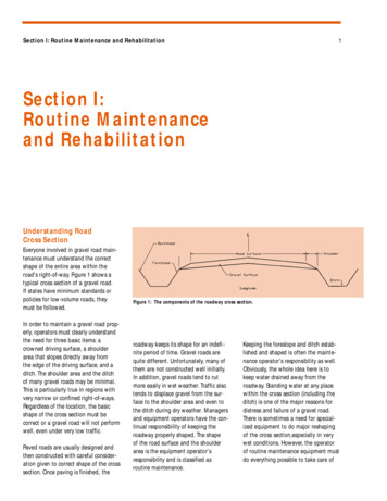
“Permeable Pavement” shall mean pervious concrete, porous asphalt, permeable pavers or other forms of pervious or porous pavingmaterial intended to allow passage of water through the pavement section. It often includes an aggregate base that provides structuralsupport and acts as a stormwater reservoir."Private Road" shall mean a privately owned and maintained vehicular access provided by a tract, easement or other legal means,typically serving three or more potential dwelling units."Project Engineer" shall mean a qualified professional engineer licensed to practice in the State of Washington."Public Road" shall mean a publicly owned facility providing vehicular access, including the roadway and all other improvementslocated within the County right of way."Recoverable Slope" shall mean a slope on which a driver of an errant vehicle can regain control of the vehicle. Slopes of 4H:1V orflatter are considered recoverable."Right of Way" shall mean all property in which the county has any form of ownership, interest or title, and which is held for thepurpose of public roads and associated features such as, medians, sidewalks, bicycle facilities, and public utilities. This definitionapplies regardless of whether or not any road exists thereon or whether or not it is used, improved, or maintained for public travel."Road" shall mean a facility providing public vehicular access including the roadway and all other improvements inside the right of way."Road Approach" shall mean a lane or set of lanes making up one leg of an intersection."Road", "Street" and "Highway" shall be considered interchangeable terms for the purpose of these Standards."Roadway" shall mean the pavement width plus any paved or non-paved shoulders for vehicular use."Rural Areas" shall mean areas so designated in Kitsap County Comprehensive Plan, and as implemented through community plansand area zoning, characterized by long-term low density development."Shoulder" shall mean the paved or unpaved portion of the roadway outside the traveled way that is available for emergency parkingor non-motorized use."Traveled Way" shall mean the part of the road made for vehicle travel excluding shoulders and parking.8
"Urban Areas" shall mean areas so designated in Kitsap County Comprehensive Plan, and as implemented through community plansand area zoning, characterized by commercial/industrial and denser residential development."Utility" shall mean an entity providing public service such as gas, electric power, telecommunications, , stormwater management,water, sewer, or cable television, whether or not such company is privately owned or owned by a governmental entity.“Very Low Volume Local Road” shall mean a public or private roadway with an average daily traffic count of less than or equal to400-vehicles.9
Chapter 2Design CriteriaProject Engineers designing road improvements shall take into account the road’s functional class, design vehicles, design speed,design volumes, stormwater management and on-street parking requirements to make final design determinations. Roadwayalignments should be laid out to minimize impervious surface areas, preserve native vegetation and trees, and incorporate LIDstormwater management practices where feasible.2.1Functional ClassificationsThe first step in the design process is to identify the functional classification of the roadway. A description of the existing and projectedadjacent land uses shall accompany the proposal for functional classification of new facilities. This description should answer questionssuch as: Is the primary function movement or access? Is the roadway in an urban environment? Are schools nearby? What is the expected pedestrian and bicycle activity? Will the roadway serve an industrial or commercial site?Roads are most effectively classified by their function, according to the character of service they are intended to provide. The primaryfunctions of roads are to provide for mobility and access, and the degree to which these functions are provided is considered an integralpart of classifying roads. The functional classification system creates a hierarchy of classified roads.For example, a freeway provides a high degree of mobility but very limited access, available only at interchanges, which could bespaced several miles apart. Higher vehicle speeds and volumes are typical on these types of facilities and are, in fact, desirable. On theother hand, a local road in a residential neighborhood provides a high degree of access by way of numerous driveways to adjacent lots,and lower vehicle speeds and volumes are desired. Between these two extremes are the remainder of the roads, commonly called thearterial system, that provide both mobility and access.Roads are grouped into a number of different classifications for administrative, planning, and design purposes. For example, theclassification system can be used for planning of new routes, improvements to existing roads, planning for area development andproviding minimum design standards or criteria to encourage the use of the road as intended. The existing County Arterial Road10
System has been classified using the federally designated functional class system. This system is used by the federal government as ameans to distribute transportation funds to local organizations.The main considerations when classifying roads into functional groups are the travel desires of the public, land service needs based onexisting and expected land use, and the overall continuity of the system. A classification plan that fits the various classes of roadstogether into a logical pattern and assigns realistic improvement standards to each class will promote the highest overall level ofservice. Urban and rural areas have different characteristics as to density and types of land use. Consequently, the nature of road andhighway networks are fundamentally different in these areas. These Standards provide for a separate classification of urban and ruralfunctional road systems. For purpose of these Standards, rural areas are the areas designated rural in the County’s ComprehensivePlan. Likewise, urban areas are those designated urban in the same plan. In some cases an urban road section may be warranted inareas outside the urban area.Kitsap County definitions for each functional classification are presented below. The Kitsap County Comprehensive Plan,Transportation Section includes transportation plans for modes other than passenger vehicles. These modal plans are intended tooverlay onto the functional classification system. For example, the bicycle facilities plan overlays the functional classification system toidentify roadways that should include bicycle facilities as a design element.The functional classification system directly addresses all roads in unincorporated Kitsap County that are under the jurisdiction of KitsapCounty. Determination of functional classification for new roads shall be made by the County Engineer. State highways under thejurisdiction of the Washington State Department of Transportation are all legally designated arterials (RCW 46.61.195). The functionalclassifications are defined below.Limited Areas of More Intensive Development (LAMIRDs) are unique areas lying outside of the Urban Growth Area. They are existingrural residential communities or villages, areas of mixed use activity, isolated areas of small-scale commercial/industrial activity andhistoric towns. Many of these zones have land use patterns that are urban in character. At the direction of the County Engineer,roadway projects within LAMIRDs may be required to provide an urban road section or other amenities that may be required by anadopted community plan.2.1.1Federal Functional ClassificationsThe county arterial road system is divided into three federal functional classifications, Principal Arterial, Minor Arterial, andCollector.2.1.1.1 Principal Arterials Principal arterials provide a network of roads which can be identified as unusuallysignificant to the area in which it lies in terms of the nature and composition of travel it serves. In urban areas, these11
facilities may be very limited in number and extent, and their importance may be primarily derived from the serviceprovided to travel passing through the area. In urbanized areas, their importance also derives from service to ruraloriented traffic, but equally or even more important, from service for major travel movements within these urbanizedareas.Urban principal arterials serve the major centers of activity of metropolitan areas, the highest traffic volume corridors, andthe longest trips. They carry a high proportion of the total urban area travel on a minimum of roadway mileage. Principalarterials carry the major portion of trips entering and leaving urban areas, as well as the majority of through movementsbypassing the central city. They also serve significant intra-area travel, such as between central business districts andoutlying residential areas, between major inner city communities, or between major suburban centers. Frequently,principal arterials carry important intra-urban and inter-city bus routes. This network provides continuity both internally andfor all rural arterials that intercept the urban boundary.Rural principal arterials consist of a connected rural network of continuous routes. They provide the highest degree ofmobility, serve major centers of activity, and are the highest traffic volume corridors between suburban centers and largercommunities. They frequently carry important intra-urban and inter-city bus routes.2.1.1.2 Minor Arterials Minor arterials connect to and augment the principal arterial system, as well as connect to ruralcollector roads.Urban minor arterials provide service for trips of moderate length at a somewhat lower level of mobility than principalarterials. They also distribute travel to smaller geographic areas. Urban minor arterials contain facilities that place moreemphasis on land access. Such facilities may carry local bus routes and provide intra-community continuity but ideally donot penetrate identifiable neighborhoods.Rural minor arterials provide service to corridors with trip length and travel density greater than those predominatelyserved by rural collectors. They link cities and larger towns and form an integrated network providing intra-communitycontinuity. A rural minor arterial is typically a continuous road with a direct, rather than meandering, alignment. Ruralminor arterials are routes whose design should be expected to allow for relatively high overall travel speeds with minimuminterference to through movement. They may carry local bus routes, but ideally do not penetrate identifiableneighborhoods.2.1.1.3 Collector Collectors distribute trips from principal and minor arterials to the ultimate destination and collecttraffic from local roads and channel it into the principal and minor arterial system.Urban collectors differ from principal and minor arterials in that they may penetrate residential neighborhoods and provide12
direct land access. In the central business district and in other areas of like development and traffic density, urbancollectors may include the road grid, which forms a logical entity for traffic circulation.Rural collectors serve intra-county travel corridors linking nearby cities or towns with routes of higher classification. Theymay penetrate residential neighborhoods, provide direct land access and distribute trips from the principal and minorarterials through the area to the ultimate destination.2.1.2 Local Road Functional ClassificationsThe local road system consists of local collectors, and localroads,, and very low volume local roads. The local road system emphasizes land access in lieu of mobility. Local roads providedirect access to abutting land and provide service for trips of relatively short distances. Local roads should be designed for arelatively uniform low volume of traffic upon full development, particularly local roads . The system should be designed todiscourage excessive speeds and should minimize the necessity for traffic control devices. Internal roads with direct lot accessshould be discontinuous so as to discourage through traffic.2.1.2.1 Local Collector serve as primary access to a development from the adjacent road system, providingcirculation within neighborhoods. They channel traffic to the collector system from the local road minor classification inresidential neighborhoods . A local sub-collector usually serves one neighborhood or a combination of a few smalldevelopments, rather than interconnecting two or more larger neighborhoods. Abutting residences are oriented away fromthe local sub-collector and direct lot access is discouraged.Local collectors serve residential single family, multiple dwelling developments, commercial business office, professionalactivities, and industrial development.2.1.2.2 Local Roads provide direct access from abutting land to local collectors. They are typically aninternal subdivision road providing circulation within the subdivision. A local road is designed so that it can neverbecome a higher classification roadway.2.1.2.3 Very Low Volume Local Road are Local Roads with an average daily traffic (ADT) of less than or equal to400. They are typically low speed roads within subdivisions where direct lot access is provided. Specific designparameters, features, and treatments such as low speed curves and “L Intersections” may be applicable to theseroadways.2.2 Design Vehicle13
Roadway design shall take into account the weight, dimensions, and operating characteristics of vehicles expected to travel on theroadway. The road’s geometry shall accommodate the physical dimensions and turning radius of selected “design vehicles.” Criticalfeatures such as road radii at intersections and on curves are generally designed for the largest design vehicle likely to use the roadwith considerable
C. Standard Plans for Road, Bridge and Municipal Construction, published by WSDOT. D. Design Manual, published by WSDOT. E. Local Agency Guidelines, published by WSDOT. F. Guidelines for Geometric Design of Very Low-Volume Local Roads (ADT less than or equal to 400), published by the American
