Transcription
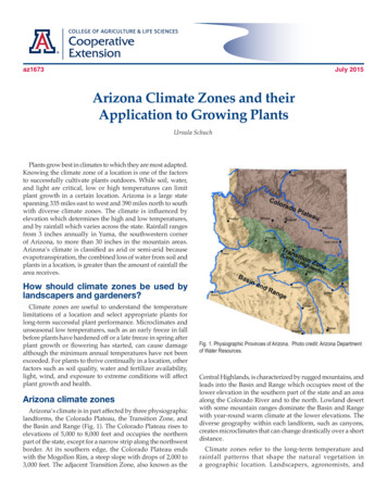
az1673July 2015Arizona Climate Zones and theirApplication to Growing PlantsUrsula SchuchPlants grow best in climates to which they are most adapted.Knowing the climate zone of a location is one of the factorsto successfully cultivate plants outdoors. While soil, water,and light are critical, low or high temperatures can limitplant growth in a certain location. Arizona is a large statespanning 335 miles east to west and 390 miles north to southwith diverse climate zones. The climate is influenced byelevation which determines the high and low temperatures,and by rainfall which varies across the state. Rainfall rangesfrom 3 inches annually in Yuma, the southwestern cornerof Arizona, to more than 30 inches in the mountain areas.Arizona’s climate is classified as arid or semi-arid becauseevapotranspiration, the combined loss of water from soil andplants in a location, is greater than the amount of rainfall thearea receives.How should climate zones be used bylandscapers and gardeners?Climate zones are useful to understand the temperaturelimitations of a location and select appropriate plants forlong-term successful plant performance. Microclimates andunseasonal low temperatures, such as an early freeze in fallbefore plants have hardened off or a late freeze in spring afterplant growth or flowering has started, can cause damagealthough the minimum annual temperatures have not beenexceeded. For plants to thrive continually in a location, otherfactors such as soil quality, water and fertilizer availability,light, wind, and exposure to extreme conditions will affectplant growth and health.Arizona climate zonesArizona’s climate is in part affected by three physiographiclandforms, the Colorado Plateau, the Transition Zone, andthe Basin and Range (Fig. 1). The Colorado Plateau rises toelevations of 5,000 to 8,000 feet and occupies the northernpart of the state, except for a narrow strip along the northwestborder. At its southern edge, the Colorado Plateau endswith the Mogollon Rim, a steep slope with drops of 2,000 to3,000 feet. The adjacent Transition Zone, also known as theFig. 1. Physiographic Provinces of Arizona. Photo credit: Arizona Departmentof Water Resources.Central Highlands, is characterized by rugged mountains, andleads into the Basin and Range which occupies most of thelower elevation in the southern part of the state and an areaalong the Colorado River and to the north. Lowland desertwith some mountain ranges dominate the Basin and Rangewith year-round warm climate at the lower elevations. Thediverse geography within each landform, such as canyons,creates microclimates that can change drastically over a shortdistance.Climate zones refer to the long-term temperature andrainfall patterns that shape the natural vegetation ina geographic location. Landscapers, agronomists, and
Fahrenheit increments. Further refinement is provided bydividing each zone into “a” and “b” subzones based on5 degree increments. Zone 1 starts at -60 F and zone 13applies to subtropical and tropical locations where minimumtemperatures drop only to 50 F to 60 F. USDA Hardiness zonesin Arizona range from 4b to 10b (Fig. 2). Coldest locations inzone 4b, where temperatures drop to -20 F to -25 F, includethe San Francisco Peaks, the White Mountains, and MountGraham. Residents of Flagstaff, Arizona live in zone 6a, wheretemperatures dip to -10 to -5 F and plant material needs tobe hardy to these temperatures to survive. The warmestlocations are located in the southwestern and southcentralpart of the state, zone 10, mainly along the Colorado River andthe Phoenix metropolitan area with minimum temperaturesbetween 30 F to 40 F.Fig. 2. USDA Plant Hardiness Zone Map for Arizona assigns zones based onthe average annual minimum temperatures and ranges from zone 4b to 10b.gardeners know how to select appropriate soils or how tochange the soil conditions so they are favorable to the plantsthey cultivate. Irrigation is generally available to supplementrainfall. However, minimum and maximum temperaturesoutdoors cannot be changed and determine which plants canbe cultivated successfully in a certain location. Three climatezone maps using different criteria are available for Arizonaresidents to choose suitable plant material for individualzones. The United States Department of Agriculture (USDA)Hardiness Zone Map (Fig. 2) classifies zones by minimumtemperature. The American Horticulture Society (AHS)Heat Zone map uses the number of days above a thresholdtemperature, and the Sunset climate zones are defined by acombination of climate factors. Table 1 lists the three typesof zones for the major cities in Arizona. Table 2 lists commonlandscape plants and their classification for the three climatezone maps.The USDA Hardiness Zone Map (2012) is based on theaverage annual minimum winter temperature in a geographiclocation and is based on temperature records collected from1976 to 2005. Zones range from 1 to 13 with 10-degree2The University of Arizona Cooperative ExtensionThe USDA Hardiness zone map can be accessed at http://planthardiness.ars.usda.gov/PHZMWeb/. The quickest wayto find the USDA hardiness zone of an area is the zip codefinder. The interactive map of the website allows viewing aterrain, road, or satellite map of an area with optional layeringof the maps. Pointing plus clicking to any location shows thezone, average minimum temperature, temperature range ofthe zone, and latitude and longitude. The interactive mapwas constructed using grid cells with a size of half a mile.This detailed information is especially valuable where rapidelevation changes occur over short distances and result inchanges in climate zones.The USDA Hardiness Zone map delivers great accuracyfor Arizona regarding the minimum temperatures we canexpect based on recent 30 year averages. This is useful inselecting well-adapted plant material for a location. Selectionof marginally hardy plant material grown outdoors needs tobe carefully matched to the expected minimum temperatures.Microclimates are affected by their immediate surroundingsand are often warmer in urban areas where heat is absorbed,stored, or reflected, and colder in areas where strongtemperature inversions occur, especially along rivers andwashes.Plant species are assigned USDA hardiness zones basedon trials of growing plants in different regions. Long-termsurvival in the coldest zone a given species was evaluatedin earns the species the rating for that zone. These trials arecarried out by botanical gardens, nurseries, and differentorganizations involved in plant research. There is no singlesource where the USDA hardiness zones of plants arepublished. This information can be found in horticulturebooks, nursery catalogs, and many websites providing plantdescriptions. It is common to find slightly different USDA
hardiness zones for one species when different entities testedthe plant. New species and cultivars entering the market aregenerally tested in several locations to inform consumersabout the minimum temperatures these plants can tolerate.When it comes to hardiness, cold is only one extreme plantsexperience during the year. USDA zones 9a and 9b common insouthern Arizona also occur along the Oregon Coast and onthe tip of the Olympic Peninsula in Washington. However, weknow not to choose plants that thrive in those coastal regionsbecause plants in southern Arizona are exposed to large dailyfluctuations in temperature, low humidity, and extremelyhigh summer temperatures which can be more stressful thanlow winter temperatures. For nurseries, landscapers, andgardeners in the Southwest, the Sunset climate zones are themost comprehensive source to use for choosing plant materialthat is well adapted to the vagaries of desert climate.The Sunset climate zones consider all aspects ofclimate such as latitude, high and low temperatures, elevation,ocean or continental air influence, and humidity. Plant growthis also affected by the length of the growing season, first andlast frost date, and the annual pattern and amount of rainfallwhich is incorporated into the Sunset climate zones. Maps ofthe climate zones are found at:http://www.sunset.com/garden/climate-zones.The warmest locations in Arizona are assigned Sunsetclimate zone 13, the low or subtropical desert areas. Thiscovers elevations up to 1,100 feet and includes the Phoenixarea to Yuma, and land along the Colorado River. Averagesummer temperatures reach 107 F, but up to 15 nights offreezing temperatures, mostly in December and January, limitthe plant palette. Tender subtropical plants can survive thefreezes if they grow in protected locations, depending on theplant species, lowest temperature, and duration of freezing.Zone 12, the intermediate desert has on average 5 morefreezing nights than zone 13, but with lower temperaturesand over a longer period of time. Summer temperatures areabout 5 F cooler than in zone 13. When growing deciduousfruit trees that require winter chilling (a minimum numberof hours of temperatures between 45 F and 32 F) in zone 12or 13, select varieties having a low chilling requirement (lessthan 300 hours) to ensure a good crop every year. Subtropicalplants in zone 12 need to be tolerant of cold temperatures.Cool season vegetables are grown most successfully in bothzones from September to late spring.Sunset climate zone 10, the high desert areas of Arizonaand New Mexico, applies to locations 3,300 to 5,000 feet inelevation. In this zone 75 to 100 nights of freezing temperaturesoccur and extreme lows of -10 F have been recorded. Thegrowing season is approximately 7 months from early Apriluntil early November. Zone 3A, the mild areas of mountainand intermountain climates, is found around Prescott andeast of Flagstaff to New Mexico. The growing season extendsfrom May to mid- October and average winter minimumtemperatures range from 15 F to 25 F. Zone 3B, the mildestareas of the intermountain climates is represented with asmall area in Southeast Arizona and around Tuba City in thenorthern part of the state. This zone is similar to zone 3A withslightly warmer winters, warmer summers, and a growingseason about one month longer.Zone 2B, the warmer-summer intermountain climate, isprominent in the area of the Colorado Plateau and somemountains in Southeast Arizona. The warm growingseason lasts from May to September and average minimumtemperatures in winter are from 12 F to 22 F. The coldestzones in Arizona are 2A and 1A and are found at the highestelevations in the state. Long, snowy winters and brief growingseasons restrict the plant palette to hardy evergreens, somedeciduous woody plants, and herbaceous perennials.The Sunset Publishing Company is the sole referenceauthority assigning specific climate zones to a plant. Theirdesignations are based on the input of many experts and areregularly updated and expanded with additional plants. Inaddition to the climate zones, individual plant descriptionshave information about light and irrigation requirements.The Plant Heat Zone Map was developed in 1997 bythe American Horticultural Society (AHS) using daily hightemperatures recorded by the National Weather Service from1974 to 1995. The 12 zones of the heat zone map are classifiedbased on the number of heat days with temperatures above86 F (30 C), which assumes (sometimes incorrectly) thatplants begin to experience serious heat stress or cell damageabove this temperature. Zone 1 has less than one heat dayand zone 12 has more than 210 heat days. The map can beaccessed gmaps/heat-zone-map.In Arizona, heat zones span from zone 4, with more than15 to 30 heat days at the high elevations in the north, to zone11 with more than 180 to 210 heat days. Most of the area ofthe Colorado Plateau and the Transition zone are classified aszones 4 to 8 with more than 14 to 120 heat days. Heat zonesare relevant for plants that suffer from heat stress abovethe threshold temperature. However, many plants nativeor adapted to the Arizona low elevation climate are desertplants that thrive when temperatures are well above 86 F ona daily basis.The University of Arizona Cooperative Extension3
Heat zone classifications of plants are found in the HeatZone Gardening reference book (see References: Cathey, 1998)and are based on the adaptability of plants to summer heatand optimum performance. This means that plants can growacceptable in warmer or cooler heat zones, but not necessarilywith top performance. Heat zones are assigned only to thegenus, not individual species, although most descriptions usespecies or cultivar examples in their description. Heat zoneclassification of plants has not been updated or expandedsince the publication of the original reference book in 1998 anddoes not cover many plants relevant for Arizona landscapes.Arizona Department of Water Resources. Physiographicprovinces of Arizona. www.azwater.gov. Accessed3/2/2015.Brenzel, K.N. 2012. The New Sunset Western Garden Book, 9thEd., Time Home Entertainment Inc. New York, New York.Cathey, H.M. 1998. Heat-Zone Gardening: How to ChoosePlants that Thrive in your Region’s Warmest Weather.Time-Life Inc., New York, New York.Sunset. Sunset climate zones. http://www.sunset.com/garden/climate-zones. Accessed 3/2/2015.ReferencesAgricultural Research Service, U.S. Department of Agriculture.2012. USDA Plant Hardiness Zone Map. http://planthardiness.ars.usda.gov. Accessed 2/25/2015.American Horticulture Society. Heat Zone ngmaps/heat-zone-map. Accessed 3/2/2015.Table 1. Cities in Arizona and their classification according to the USDA Hardiness Zones, the Sunset Climate Zones, and the AHS Heat Zones.USDAHardinessZoneMinimumTemperature( F)Sunsetclimatezone6a-10 to -52B7a0 to 57bAHS HeatZoneNo. daysabove 86 FWarmer summerintermountain climate21-72BWarmer summerintermountain climate415 - 305 to 103AMild mountain and intermountain climates646 - 607b5 to 103BMildest mountain and intermountainclimates891 - 120Willcox8a10 to 1510Arizona - New Mexico high desert9121 - 150Bisbee8a10 to 1510Arizona - New Mexico high desert646 - 60Sedona, SierraVista, CampVerde, Page, andKingman8b15 to 2010Arizona - New Mexico high desert891 - 120Safford8b15 to 2012Arizona’s intermediate desert9121 - 150Globe9a20 to 2510Arizona - New Mexico high desert761 - 90Casa Grande9a20 to 2512Arizona’s intermediate desert11181 - 210Tucson9b25 to 3012Arizona’s intermediate desert10151 - 180Phoenix Metro9b25 to 3013Low or subtropical desert10151 - 180Ajo10a30 to 3512Arizona’s intermediate desert11181 - 210Bullhead City,Lake Havasu City,and Yuma10a30 to 3513Low or subtropical desert11181 - 210CityFlagstaffShow LowPrescottTuba City4The University of Arizona Cooperative ExtensionSunset zone description
Table 2. Commonly used landscape plant materials used in Arizona and their classification according to US Department of Agriculture Hardiness Zone, SunsetClimate Zone, and American Horticulture Society Heat Zone.Latin NameTreesCommon NameUSDA Hardiness Zone1Acacia farnesianaSweet acacia9 - 11Acacia stenophyllaShoestring acaciaAcer x freemaniiFreeman mapleCatalpa bignonioidesSunset Climate Zone2 AHS Heat Zonee38, 9, 12 - 2412 - 19 - 118, 9, 12 - 2412 - 13-92A, 3A, 1 - 9, 14 - 1710 - 3Southern catalpa5-93 - 10, 14 - 24-Celtis reticulataWestern hackberry5 - 132 - 24, best in 2, 3, 7 -13,18 - 21-Cercis occidentalisWestern redbud7-92 - 2412 - 9Chilopsis linearisDesert Willow7 - 113B, 7 - 14, 18 - 2311 - 7X Chitalpa tashkentensisChitalpa6 - 113 - 24-Cupressus arizonicaArizona cypress7-97 - 249 -3Dalbergia sissooIndian rosewood, Sissoo9, 10 - 1113, 19, 21 - 24-Ebenopsis ebanoTexas ebony8 - 1112, 13-Ficus caricaFig, edible8 - 114 - 9, 11 - 2412 - 1Fraxinus pennsylvanicaGreen ash3-91-68-2Fraxinus velutinaArizona ash7 - 113B - 248-2Juglans majorArizona walnut4-910 - 13-Juniperus deppeanaAlligator juniper7-91 - 3, 10 - 129-1Malus sp.Flowering crabapple4-81 - 11, 14 - 218-2Parkinsonia floridaBlue palo verde8 - 118 - 14, 18 - 20-Phoenix dactyliferaDate palm9 - 118, 9, 11 - 24-Pinus eldaricaAfghan pine6 - 116 - 9, 11 - 24-Pinus ponderosaPonderosa pine3-71 - 10, 14 - 21-Platanus wrightiiArizona sycamore7 - 1110 - 12-Prosopis glandulosaHoney mesquite10 - 1110 -13, 18 - 24-Prosopis velutinaVelvet mesquite9 - 1110 -13, 18 - 24-Quercus arizonicaArizona white oak3-9--Quercus buckleyiTexas red oak6 - 113B, 6 - 12, 18 - 22-Quercus virginianaSouthern live oak7 - 104 - 24-Robinia neomexicanaNew Mexico locust6-92, 3, 7 - 11, 14, 18 - 24-Washingtonia filiferaCalifornia fan palm9 - 118, 9, 10, 11 - 24-Washingtonia robustaMexican fan palm9 - 118, 9, 10, 11 - 24-9 - 1110, 12 - 2412 - 5Shrubs and Accent PlantsAgave americanaCentury plantAgave parryiParry’s agave9 - 112B, 3, 6 - 2412 - 5Atriplex canescensFour-wing saltbush6 - 101 - 3, 7 - 2412 - 5Caesalpinia gilliesiiBird of paradise9 - 118 - 16, 18 - 24-Caesalpinia pulcherrimaRed bird of paradise9 - 1112 - 16, 18 - 23-Calliandra californicaBaja fairy duster9 - 1112 - 16, 18 - 23-Cornus stoloniferaRed-osier dogwood3-81 - 9, 14 - 219-1Carnegia giganteaSaguaro912, 13, 18 - 21-Dasylirion wheeleriDesert spoon, Sotol8 - 1010 - 24-The University of Arizona Cooperative Extension5
123Ferocactus spp.Barrel cactus9 -118 - 24-Forsythia x intermediaForsythia4-82B - 11, 14 - 16, 18, 198-4Fouquieria splendensOcotillo8 - 1010 - 13, 18 - 20-Juniperus spp.Juniper shrubs2-91 - 249 -1Hesperaloe parvifloraRed yucca8 - 102B, 3, 7 - 16, 18 - 24-Larrea tridentataCreosote8 - 107 - 14, 18 -21-Leucophyllum spp andvarietiesTexas ranger8 - 117 - 24-Ligustrum vulgarePrivet7 - 102 - 249-1Nerium oleanderOleander8 - 108 - 16, 18 - 2412 - 1Opuntia spp.Prickly pear3 - 1112 - 24-Punica granatumPomegranate8 - 105 - 2412 - 5Rhus ovataSugar bush7 - 119 - 12, 14 - 249 -5Vauquelinia californicaArizona rosewood8 - 1010 - 13-Vitex agnus-castusChaste tree7 - 114 - 2410 -1Yucca baccataBanana yucca5 - 111 -3, 7, 9 - 14, 18 - 249-1The following references were used for USDA plant hardiness and were accessed on algarden.org/http://redwood.mortonarb.org/Only Sunset climate zones from the continental US are listed, Alaska and Hawaii zones are not included.AHS heat zones are given only for the genus.COLLEGE OF AGRICULTURE & LIFE SCIENCESCooperativeExtensionThe University of ArizonaCollege of Agriculture and Life SciencesTucson, Arizona 85721Ursula SchuchProfessor and Specialist, HorticultureContact:Ursula Schuchuschuch@email.arizona.eduThis information has been reviewed by University Other titles from Arizona Cooperative Extension can be found at:extension.arizona.edu/pubsAny products, services or organizations that are mentioned, shown or indirectly implied in this publicationdo not imply endorsement by The University of Arizona.Issued in furtherance of Cooperative Extension work, acts of May 8 and June 30, 1914, in cooperation with the U.S. Department of Agriculture, Jeffrey C. Silvertooth,Associate Dean & Director, Extension & Economic Development, College of Agriculture Life Sciences, The University of Arizona.The University of Arizona is an equal opportunity, affirmative action institution. The University does not discriminate on the basis of race, color, religion, sex, national origin,age, disability, veteran status, or sexual orientation in its programs and activities.6The University of Arizona Cooperative Extension
Arizona climate zones Arizona's climate is in part affected by three physiographic landforms, the Colorado Plateau, the Transition Zone, and the Basin and Range (Fig. 1). The Colorado Plateau rises to elevations of 5,000 to 8,000 feet and occupies the northern part of the state, except for a narrow strip along the northwest border.