Transcription
1123FireRevit: Using Revit Files to Identify the Room Locationsof Fires and Escape Routes.45LUHAN SHENG AND DENNIS SHASHA, Southwest Jiaotong University and New York University6New York University Computer Science Technical Report TR2020-99578910111213141516171819202122A Revit file is a proprietary format used by Autodesk Revit to store a building model. It contains all theinformation that describes a building model, such as element and entity data, project location, etc[Fisher2020]. Since 2010, to enable advanced users and third-party developers to integrate their applications into theAutodesk Revit family of products, Autodesk has permitted developers to use the API provided by Revit toobtain building data[Autodesk 2020]. In fact, one can now process large quantities of Revit files and extractbuilding information automatically[Mason 2009].Based on this, FireRevit consists of a parser for all the building model files in a given city to get the locationof any window in any building and their corresponding rooms, and create a database to persist the data.In this way, when a fire breaks out in the city and a drone sighting of the fire gives latitude,longitude andheight, FireRevit can help firefighters determine the building and room where the fire occurred by retrievingrecords from the database.FireRevit also combines the Revit file and information about which rooms are inaccessible due to fire toguide residents to the nearest exit.Additional Key Words and Phrases: Autodesk, Revit, firefighting, fire 45464748Author’s address: Luhan Sheng and Dennis Shasha, Southwest Jiaotong University and New York University, wc36170565@gmail.com,shasha@cims.nyu.edu.2019. XXXX-XXXX/2019/8-ART1 15.00https://doi.org/49, Vol. 1, No. 1, Article 1. Publication date: August 2019.
ContentsAbstract121 Architecture1.1 Revit converting module . . . . . . . . . . . . . . . . . . . . . . . . . . . . . . . . . . . . . . . . . . . . . .1.2 Room finding module . . . . . . . . . . . . . . . . . . . . . . . . . . . . . . . . . . . . . . . . . . . . . . . . .3332 Core converting and finding steps2.1 Part one: Revit file conversion . . . . . . . . . . . . . . . . . . . . . . . . . . . . . . . . . . . . . . . . . .2.2 Part two: room finding . . . . . . . . . . . . . . . . . . . . . . . . . . . . . . . . . . . . . . . . . . . . . . .4463 Installation74 Running the Project4.1 Data conversion . . . . . . . . . . . . . . . . . . . . . . . . . . . . . . . . . . . . . . . . . . . . . . . . . . . . .4.2 Room finding . . . . . . . . . . . . . . . . . . . . . . . . . . . . . . . . . . . . . . . . . . . . . . . . . . . . . . .4.3 Other requirements . . . . . . . . . . . . . . . . . . . . . . . . . . . . . . . . . . . . . . . . . . . . . . . . . .101010105 Checking for Data Errors116 Example6.1 First step: Preparing the Revit file . . . . . . . . . . . . . . . . . . . . . . . . . . . . . . . . . . . . . . .6.2 Second step: Running FireRevit . . . . . . . . . . . . . . . . . . . . . . . . . . . . . . . . . . . . . . . . .6.3 Third step: Find the target window using given coordinates . . . . . . . . . . . . . . . . . .121213147 Escape Routes for People Inside the Building7.1 Architecture . . . . . . . . . . . . . . . . . . . . . . . . . . . . . .7.2 Brief of Data extraction . . . . . . . . . . . . . . . . . . . . .7.3 Details about data extraction . . . . . . . . . . . . . . . . .7.4 Overview Path Finding . . . . . . . . . . . . . . . . . . . . .7.5 Details of Path finding . . . . . . . . . . . . . . . . . . . . . .7.6 Requirements on the Information in the Revit File7.7 Installation . . . . . . . . . . . . . . . . . . . . . . . . . . . . . . .7.8 Running the project . . . . . . . . . . . . . . . . . . . . . . . .7.9 Example . . . . . . . . . . . . . . . . . . . . . . . . . . . . . . . . .15151515171818181920. . . . . . . . . . . . . . . . . . . . . . . . . . . . . . . . . . . . . . . . . . . . . . . . . . . . . . . . . . . . . . . . . . . . . . . . . . . .8 Conclusion25References252
FireRevit: Using Revit Files to Identify the Room Locations of Fires and Escape 364656667686970Fig. 1. Flow chart of this project. There are four major components and can be divided into two modules(Revitconverting module and Room finding module).717273747576Github repository: https://github.com/LuhanSheng/Revit To DatabaseRevit converting module: folder named 𝐷𝑎𝑡𝑎 𝑐𝑜𝑛𝑣𝑒𝑟𝑡𝑖𝑛𝑔: file RevitToDatabase.csproj is the filethe user should open in Visual Studio.Room finding module: folder named 𝑅𝑜𝑜𝑚 𝑓 𝑖𝑛𝑑𝑖𝑛𝑔: file window finder.py is the file to open inPython.7778798081828384858687881.1Revit converting moduleThis module contains two components and its function is to extract the data we need.1. Revit file: All the Revit files should be provided in a folder. The file name of each file shouldbe set to the building name.2. Data conversion: This process is responsible for parsing the location of the windows andconverting them into geographic locations (latitude, longitude, and height). To achieve this, theprocess will first find the Revit process on the machine and get authorization from it. So Revitshould be installed on the machine before running it. After conversion, the window location andcorresponding room information will be stored in a MySQL database. The file names of all convertedfiles will be saved to ensure that a file will not be stored multiple times when FireRevit is runmultiple times. In other words, the process will convert only newly added files.899091929394959697981.2Room finding moduleThis module contains two components whose purpose is to find a room corresponding to a window.1. Window position: The Window position comes in from the drone/detector in the format of(latitude, longitude, height). The height here refers to the height from the window to the ground.In section 4, we will show how to convert this to a height with respect to the base point.2. Room finding: This process is responsible for finding the window and its corresponding room.The process will start by ranking windows by their proximity to the point in three-space found bythe drone. Finally, it will output the building name, room name and corresponding coordinates.
1:4Luhan Sheng and Dennis Shasha9921002.1 Part one: Revit file conversionTo parse the Revit file using the Revit api without opening Revit, acquire the window coordinatesand convert them into geographic positions (latitude, longitude, height from the ground). Thepseudocode of this part, see below:101102103104CORE CONVERTING AND FINDING STEPS105106107108109110111112Algorithm 1: Converting Revit file to find the window locations of every roomInput: 𝐹 is a set containing all the Revit filesOutput: 𝑁𝑈 𝐿𝐿1 for each file 𝐹𝑖 in the set 𝐹 do2𝐹𝑆 get the set of all the files which have been converted ;3if 𝐹𝑖 𝐹𝑆 then4delete 𝐹𝑖 from 𝐹 241251516Find the Revit installed on the machine and load dynamic link library from the Revit;Get authorization from Revit;for each file 𝐹𝑖 in the set 𝐹 do𝑓 get file name ;𝑔𝑠 get geographic position of survey point ;𝑏 get xyz bias of base point ;𝑎 get the angle to north of the coordinate system;𝑊 select all the window elements among all elements ;for each window 𝑊𝑖 in the set 𝑊 dodetermine the room 𝑟 the window belongs to ;if 𝑟 𝑛𝑢𝑙𝑙 thendelete 𝑊𝑖 from 𝑊 1391402223242526141271422814329for each window 𝑊𝑖 in the set 𝑊 dodetermine the coordinate 𝑐 of the window ;rotate the coordinate 𝑎 degree around base point (0, 0): 𝑐𝑟 𝑟𝑜𝑡𝑎𝑡𝑒 (𝑐, 𝑎);compute the coordinate of 𝑐𝑟 using the survey point as origin point : 𝑐𝑠 𝑐𝑟 𝑏 ;compute the fraction of degrees corresponding to one foot (30.48 centimeters) equalto (the ratio of one foot and one degree of latitude/longitude, e.g. at latitude L1 theratio is : 𝑟𝑙 𝑜 𝑛𝑔 𝑐𝑜𝑠 (𝑎𝑏𝑠 (𝐿1)/180) 40076000/360 3.28083989501𝑟𝑙 𝑎𝑡 111322.222222222 3.28083989501;compute the geographic position bias of the window: 𝑔𝑏 𝑐𝑠 /𝑟 ;compute the geographic position of the window: 𝑔𝑤 𝑔𝑠 𝑔𝑏 ;create a connection to the database ;if database does not exist thencreate a new database and table ;store the window information (𝑓 , 𝑟, 𝑔𝑤 ) into database ;draw a picture to show the positions of windows and base point;add 𝐹𝑖 into set 𝐹𝑆 ;144145146147The pseudo-code described above consists of several C files:
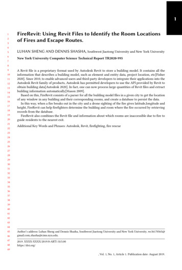
FireRevit: Using Revit Files to Identify the Room Locations of Fires and Escape Routes.1481491501511:5(1) Line 1 to line 6 are in Program.cs.(2) Line 7 to line 31 are in ProcessRevitFiles.cs.Details about function rotate() used in line 21 of Algorithm 1:Part of the code of function rotate() in room finder.py:1521531154215515615734y xlxc target point[0] * (-1) target point[1] * 1 / math.tan(angle)x xlxc target point[0] * 1 target point[1] * math.tan(angle)x abs((1 / math.tan(angle) * target point[0] target point[1]) / ((1 (1 /math.tan(angle)) ** 2) ** 0.5))y abs((-math.tan(angle) * target point[0] target point[1]) / ((1 math.tan(angle) **2) ** 0.5))158159160161162163164165166167168169target point is the coordinate of the point we want to rotatetarget point[0] refers to xtarget point[1] refers to yangle is the angle we want to rotatey xlxc indicates whether the point is to the left or the right of the y axisx xlxc indicates whether the point is to the above or below the x axisx is the distance from the result point to the y-axisy is the distance from the result point to the x-axisWe can know which quadrant the target point is in by looking at 𝑦 𝑥𝑙𝑥𝑐 and 𝑥 𝑥𝑙𝑥𝑐.Also, we knowthe absolute values of the abscissa and ordinate. Thus, we can get the coordinates of the resultpoint easily. Here is an example to show 185186187188189190191192Fig. 2. Coordinate system showing how a point is rotated. S is the survey point, the X-axis is parallel to theweft and the Y-axis is parallel to the warp. B is the base point, coordinate system 𝑌𝐵 B𝑋𝐵 is the coordinatesystem used in the Revit model. P is the point we want to rotate. 𝜃 is the angle we want to rotate, we need toget the value of x’ and y’.193194195196First, we multiply vector 𝑉𝑝 and 𝑉𝑦 . By doing this, we can know whether the angle between 𝑉𝑝and 𝑉𝑦 is greater than 90 degrees or not. In the same way, we multiply vector 𝑉𝑝 and 𝑉𝑥 . Second,
1:6197198199Luhan Sheng and Dennis Shashawe calculate the distance from the point P to vector 𝑉𝑥 and vector 𝑉𝑦 to get the absolute value of y’and x’. Third, using the value obtained in the first step, we can determine which quadrant point Pis in, and then the sign of x’ and y’. Here is an example of rotating multiple 14215216217218Fig. 3. Red points show point positions after rotating 𝜋/4, black points show the initial positions.2192202212222232.2Part two: room findingPart two retrieves data from the database to find out the most probable room. Here is the pseudocodeof this part:224225226227228229230231232233234235Algorithm 2: Finding the window closest to the input coordinates and its roomInput: 𝑃 is the given point𝑚𝑡 is the tolerance in metersOutput: 𝑏𝑢𝑖𝑙𝑑𝑖𝑛𝑔𝑛𝑎𝑚𝑒, 𝑟𝑜𝑜𝑚𝑛𝑎𝑚𝑒, ��𝑛1 compute the degree tolerance [Degree tolerance is the maximum degree error allowed] 𝑑𝑡 :𝑑𝑡 360 (𝑚𝑡 /40000000);2 compute the upper bound and lower bound of both latitude and longitude;3 query the database by using 𝐵𝐸𝑇𝑊 𝐸𝐸𝑁 to get a set of results 𝑅;4 if 𝑙𝑒𝑛(𝑅) 0 then5return 𝑁𝑜𝑛𝑒;236623772388239924010elsefor each window 𝑅𝑖 in the set 𝑅 docompute the distance between 𝑅𝑖 and 𝑃;find the closest window and its corresponding room name and building name;return (𝑏𝑢𝑖𝑙𝑑𝑖𝑛𝑔𝑛𝑎𝑚𝑒, 𝑟𝑜𝑜𝑚𝑛𝑎𝑚𝑒, ��𝑛);241242243244245If we have a tolerance of 10(meters), then the degree tolerance here should be 10/40000000*360 0.00009, 4000000 meters is the perimeter of the earth[Wikipedia 2020], so this equation means 10
FireRevit: Using Revit Files to Identify the Room Locations of Fires and Escape Routes.2462472482492501:7meters is equal to 0.00009 degree on earth and we will choose as candidates all the rooms withinthis range. So the tolerance is used to filter away windows that are distant from the calculatedpoint.The next step is to compute the upper bound and lower bound of both latitude and longitude andusing it in the SQL to query the database. SQL used in this example 66267268269270271272273SELECT * FROM window.window WHERE (longitude BETWEEN 116.4329305 AND 116.4330694) AND(latitude BETWEEN 39.9159305 AND 39.9160694);The query generates a list of possible rooms. The next step is to find out the best one by looking attheir distances from the fire point.3INSTALLATIONNote: The IDE we used is Visual Studio(VS), So the installation shown here are based on VS. If youuse another IDE, you can just regard the part related to VS as a reference.RevitToDatabase requires python version 3.5, packages of pymysql, ironPython (v2.7.10) andMySql.Data (v8.0.21).(1) Clone code from github: https://github.com/LuhanSheng/Revit To DatabaseModule data converting is in folder 𝐷𝑎𝑡𝑎 𝑐𝑜𝑛𝑣𝑒𝑟𝑡𝑖𝑛𝑔, which is a C sharp project.Module room finding is in folder 𝑅𝑜𝑜𝑚 𝑓 𝑖𝑛𝑑𝑖𝑛𝑔, which is a python project.(2) To use the function of converting the Revit file, please:(a) Install Revit 2019 and MySQL on the machine.Here is some guidance for this process (both text and videos):Install Revit 2019: https://www.youtube.com/watch?v Wqd8N78i-eMInstall MySQL: https://www.youtube.com/watch?v WuBcTJnIuzo(b) Install and import ironpython and mysql.data in the project. Here is some guidance forthis process:1. Open the C sharp project in VS, then find the solution 7288289290291Fig. 4. Visual Studio interface. Red box shows the position of solution explorer.2922932942. Right click the project in Solution Explorer, then click Manage Nuget.
1:8Luhan Sheng and Dennis g. 5. Visual Studio interface. Red box shows the position of Manage Nuget.3093103. Search for package IronPython and MySql.Data and click the button to install them311312313314315316317318319320321322323324Fig. 6. Visual Studio interface. Red box shows the position of the package we want to install.325326327(c) Config the reference:1. Right click the project in Solution Explorer, then click Add 41342343Fig. 7. Visual Studio interface. Red box shows the position of Add Reference
FireRevit: Using Revit Files to Identify the Room Locations of Fires and Escape Routes.3443453463473483493502. Add the references of: RevitAPI.dll RevitAPIUI.dll RevitNET.dll RevitAddInUtility.dll(find these assemblies in the installation directory of Revit), as shown in the 62363Fig. 8. Reference manager of Visual Studio after adding these references.3643653. Click RevitAddInUtility and set the property of Copy Local to 381382383384385386387Fig. 9. Visual Studio interface. Red box shows the position of RevitAddInUtility and Copy Local3883893903913921:9(3) To use the function of room finding, please run the following command:pip install pymysql
1:10Luhan Sheng and Dennis Shasha3934394RUNNING THE PROJECTAt present, this project can run only on windows.3953963973983994004.1Data conversion(1) Project configurationSolution configuration: DebugSolution platform: x64Target framework: .NET Framework 5Fig. 10. Project configuration of this project.416417418419(2) Running the projectClick the start button to compile and run.4204214224234244254264274.2Room finding(1) Project configurationPlease set the tolerance in window finder.py at line 13 first, the default value is 10(meters).(2) Running the projectpython window finder.py latitude longitude heightFor example:python window finder.py 30.5723038 114.2792084 r requirements(1) Database configurationPlease fill in your own database username and password in the code, both in file config.csand in window finder.py. The default ip address and port number is 127.0.0.1 and 3306, youcan also choose to modify them.(2) Adding Revit filesPlease put the Revit file under the folder named rvtFiles. Then, please make sure that there isa file named converted files.txt in the folder rvtFiles and it should be empty if you have neverrun FireRevit. File names of all converted files will be stored in converted files.txt. Once aRevit file’s name is recorded in there, this Revit file will not be converted by FireRevit again.(3) Drone requirementsDrone will have to get the height of the burning window with respect to the first (ground)
FireRevit: Using Revit Files to Identify the Room Locations of Fires and Escape Routes.1:11floor, yielding DroneFireHeight. To convert this to a Revit height which is with respect tothe base point, we simply add (FirstFloorHeight - basepoint) to DroneFireHeight. That �ℎ𝑡 ��ℎ𝑡 ���𝑔ℎ𝑡 𝑏𝑎𝑠𝑒𝑝𝑜𝑖𝑛𝑡).(1)446447(4) Revit file requirementsPlease make sure all the file names are the building names. Then, make sure your Revit fileversion number is strictly greater than 2013. If not, open the Revit file in Revit to update it.Based on (1) mentioned above, FireRevit needs to know the height of the first floor, and thisvalue is determined by the elevation of Revit level.So it is necessary to check that the name of the level complies the naming rules, that is, thefirst floor level has digit "1" in its name. For instance, "LEVEL 01", "L1", "F1", "F01" complywith the naming rules. FireRevit will find out which level’s name has number "1" and use itsheight as the height of the ground KING FOR DATA ERRORSSometimes, though rarely, there is a problem in that the base point in the Revit file is not at (0,0).To see whether this is a problem, please follow these steps:461462463(1) Please open the Revit file in Revit to view the floor plan, click the lamp bulb to show thehidden base 8479480481482483484Fig. 11. Revit interface. Red box on the left shows the position of lamp bulb and red box on the right showsthe position of base point.485486487488489490(2) FireRevit produced a file called 𝑓 𝑖𝑙𝑒𝑛𝑎𝑚𝑒.jpg in the folder named images. Now, open it andcompare the base points of the two pictures to see if they are the same.
1:12Luhan Sheng and Dennis 5Fig. 12. Sample picture generated after running. Red square shows the position of base point.506507Apparently, these two base points are not the same. So there must be something wrong withthe Revit file. As of this writing, we can not process the data from this building, so we shouldsimply delete this building model from the database.(3) Please open the file converted files.txt in the folder named revitFiles, check that whether allthe names of the Revit files you want to convert are in this txt file. Note that there is one filename per line.(4) After following the instructions mentioned above, the correct data should be stored in thedatabase already. It might be good to check.5085095105115125135145155166517EXAMPLEAn example to show how FireRevit works.5185195205215226.1First step: Preparing the Revit file(1) The file name should be the building name. In this example, the building name is canteen.(2) Put the file into the folder named rvtFiles and make sure converted files.txt is empty.(3) You can choose to open this file in Revit, these two pictures shows the design of example 538539Fig. 13. 3D view and plan view of this building.
FireRevit: Using Revit Files to Identify the Room Locations of Fires and Escape Routes.5405415425436.21:13Second step: Running FireRevit(1) Follow the steps mentioned in section 3 and 4 to install and configure.(2) Compile and run.(3) The result will be stored in the 7558559Fig. 14. Database table and data.560561562(4) Open the folder whose name is images and check the points in the picture 5576577578579Fig. 15. 3D view and plan view of this building.580581582583584585586587588Note that it is important to check the position relationship between the window points andthe base point. If we have no base point or an incorrect base point, then all the data will beincorrect. Please just delete all the wrong data FireRevit just stored into database.These points are consistent with the windows in the model we just opened in Revit, see thepicture Plan view in subsection 5.1. So we have all the data we want and they are in thedatabase now.
1:14Luhan Sheng and Dennis Shasha5896.3590After storing the data in the database, we can use the room finding module to find the correspondingroom using the given coordinates.(1) Adjust the variable tolerance in line 13 of window finder.py to an appropriate value.591592593Third step: Find the target window using given coordinates594595596597598599600Fig. 16. Tolerance. Default value is 10.601602603604605606607608609610611612The tolerance is a kind of filter to help FireRevit faster. Regardless of the tolerance is, we willget one final result room.(2) Follow the steps mentioned in section 3 and 4 to install and configure(3) Run window finder.py and the coordinates given by the drone is entered as a command lineparameter into FireRevit. Now, we assume a fire broke out at the room whose room id is 210,which is also the last room in subsection 5.2, item 3. The drone finds that this room is on fireby looking at its window. The coordinates it gives is 30.5723038, 114.2792084, 8 (here, someerror is added deliberately to simulate the actual situation).The command in this example should be:python window finder.py 30.5723038 114.2792084 8(4) The result will appear on the console:613614615616617618619Fig. 17. Result of 634635636637Building ’canteen’, Room ’xxx 210’ is the room we want, level name of this room is F2. Thiswhole room name(room name level name) can be used in the Escape route finding module,described in the next section.
FireRevit: Using Revit Files to Identify the Room Locations of Fires and Escape Routes.63876397.16401:15ESCAPE ROUTES FOR PEOPLE INSIDE THE 651652653654655656657658659660Fig. 18. Flow chart of this part. There are four major components and can be divided into two modules(Dataextraction module and Path finding 6756766776786796806816826836846856867.2Brief of Data extractionThis module contains two components and its function is to extract the data we need.Revit file: All the Revit files should be provided in a folder. The file name of each file should be setto the building name.Data extraction:This process is responsible for parsing the rooms in the building into nodesand the doors, empty spaces and stairs into edges. The net result is an undirected graph. Toachieve this conversion to a graph, the process will first find the Revit process on the machineand get authorization from it. So Revit should be installed on the machine before running it. Afterconversion, the data of these element mentioned above will be stored in a MySQL database. Thefile names of all converted files will be saved to ensure that a file will not be stored multiple timeswhen FireRevit is run multiple times.7.3Details about data extractionThis part will describe in detail how FireRevit obtains the graph model step by step. Note that thispart helps you to understand FireRevit, but if you’re just trying to use it, you can skip this section.In order to represent the building model as a graph, we want nodes to be rooms and edges to beconnections between rooms. In addition, we need to obtain the information of walls and boundariesto visualize the escape path.(1) Room(node) dataWe represent each room (node) by its center point. The room’s name and level is the uniqueidentifier for the room and therefore the corresponding node. In addition, as we will give theshortest possible escape path, we need to know which rooms are exit rooms. Such exit roomswill be regarded as the end of each escape path. For each exit room, we need to save which
1:16687688689690691Luhan Sheng and Dennis Shashadoor of the room is the exit door. The reason is that if the exit room has many doors or thearea of the exit room is large, we can give a more accurate escape path. It is easy for us to getthe room location, name and level name by using the Revit API, room name and level will beused as a unique identifier so that the room name stored in the database will be in the formof 𝑟𝑜𝑜𝑚𝑛𝑎𝑚𝑒 6697698699700701702703704705706707708How do we know which rooms are exit rooms?The approach is to find the rooms on the ground floor that have boundaries to the outside. Ifsuch rooms have doors to the outside, they are exit rooms.The algorithm is divided into the following steps:(a) Find the boundaries of all the rooms on the ground floor. If two rooms r1 and r2 share aboundary (technically this means that a boundary line segment from r1 and a boundary lineare close together and parallel), then that boundary cannot be a boundary to the outside. Inaddition, we will discard boundaries that are less than one meter in length, because suchboundaries cannot include a door.(b) Get the center point of all the doors on the ground floor, which are not directly on theoutside boundary. If the distance between the center point of the door and the outsideboundary is less than a certain value (about 0.6 meters or half the width of a door), thenthe door will be regarded as an exit door.(c) Find all the rooms corresponding to exit doors, mark each such room as an exit room. If aroom has several exit doors, associate just one with that room in order to be able to givean escapee a path to a specific door. A sample resulting database table might be as follows.709710711712713714715716717718Fig. 19. Sample database table of room 734735(2) Edge dataEach edge reflects the connection relationship between two rooms in the model.There are three kinds of connections between rooms: door connection, boundary connectionand stair connection. So we need to capture all three of these connections.Edge data will include two different rooms (the two rooms connected by this edge), the lengthof the edge (from room center to room center), the type of edge.The algorithm is divided into the following steps:(a) Find all the doors in the model, get the room that the door faces, the room where the dooris located and the room with the door. Remove the duplicate rooms in the three roomsobtained, and the remaining two rooms are the rooms connected by the door.(b) Find all the stairs in the model and get the coordinates of the top and bottom of the stairs.Because a staircase may connect many floors, we start from the bottom coordinate, andincrease the height of the coordinate by one meter until the added height is greater thanthe top coordinate, and get the room that this point belongs to. In this way, we can get theall the rooms connected by this staircase.
FireRevit: Using Revit Files to Identify the Room Locations of Fires and Escape Routes.1:17(c) In the Revit model, the boundaries between rooms are not always walls. Sometimes theycan be boundaries without walls. In other words, a whole empty space may contain multiplerooms.So, first of all, We find all room boundaries and determine which boundaries containno walls. Then, if two rooms r1 and r2 share a boundary and this boundary contains no walls(technically this means that a boundary line segment from room r1 and a boundary linefrom r2 are close together and parallel), then the two rooms to which the two boundariesbelong are connected.So using this method, we can get all the edges and store the edge data into the database. Asample database table is as 750751752753754755756Fig. 20. Sample database table of edge data.757758759760761762763764(3) Wall dataIn addition to getting the information of all the nodes and edges, we also need the data of allthe walls, so that we can draw the buildings in the path map to better visualize the path.All the edges are obtained directly through the Revit API, and each edge is represented by itsstart and end point coordinates, and then data is stored in the database. A sample databasetable is as follows.765766767768769770771772773774775Fig. 21. Sample database table of wall data.7767777787797807817827837847.4Overview Path FindingThis module contains two components whose purpose is to find the shortest route to the exit.Room name: The name of the room in which the person is.Path finding This process is responsible for finding the shortest route to the exit. The process willuse Dijkstra algorithm to find all the route to the exits and output the shortest one. Besides that,some pictures showing the path will be given.
1:18Luhan Sheng and Dennis Shasha7857.5786This part will describe in detail how FireRevit reads the data in the database to build a graph, andfinds the shortest escape path according to the entered room name and building name. Note thatthis part helps you to understand FireRevit, but if you’re just trying to use
A Revit file is a proprietary format used by Autodesk Revit to store a building model. It contains all the information that describes a building model, such as element and entity data, project location, etc[Fisher 2020]. Since 2010, to enable advanced users and third-