Transcription
STATE OF CALIFORNIA—NATURAL RESOURCES AGENCYEDMUND G. BROWN JR., G OVERNORCALIFORNIA COASTAL COMMISSIONCENTRAL COAST DISTRICT OFFICE725 FRONT STREET, SUITE 300SANTA CRUZ, CA 95060PHONE: (831) 427-4863FAX: (831) 427-4877WEB: WWW.COASTAL.CA.GOVTh8bCDP 1-16-1110/CC-0003-17 (CITY OF EUREKA)JUNE 8, 2017EXHIBITSTable of ContentsExhibit 1 – Project Site MapExhibit 2 – Parcels within Project AreaExhibit 3 – Proposed Project ComponentsExhibit 4 – Jurisdictional Boundaries within Project AreaExhibit 5 – Temporary Access Roads - DownstreamExhibit 6 – Temporary Access Roads - UpsrtreamExhibit 7 – Project Staging AreasExhibit 8a – Staging and Stockpile Areas – DownstreamExhibit 8b – Staging and Stockpile Areas - UpstreamExhibit 9 – Slough Dewatering ExampleExhibit 10 – Agricultural Designations within Project Area
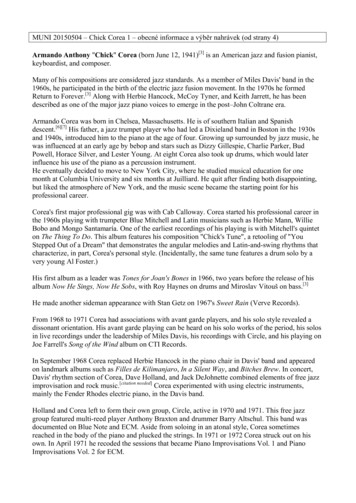
Figure 1. Martin Slough Enhancement Project Site and Watershed BoundaryEXHIBIT 1
ParcelNumberAPNLandowner LTNRLTNRLTCity of EurekaCity of EurekaCity of 65.6* County parcel boundaries incorrect. See additional pages for more information.EXHIBIT 2
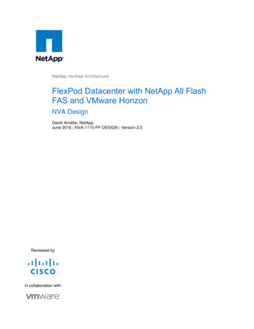
Martin Slough Enhancement ProjectDescription of Phasing and Restoration Actions(E) North ForkTributaryPhase 1 (NRLT): Installed new tide gates to restore estuarineecosystem function, increase conveyance and partially restore amuted tidalinfluence.Phase 2-4 (NRLT and lower City): Construction and enlargementof tidal and freshwater wetlands to increase floodwater storageand provide enhanced fisheries and waterfowl habitat, andenlarge the channel to increase conveyance (Reaches 1-4).Wetland and riparian plantings and creation of salt marsh plains(Marsh Plain A and B). Creation of salt marsh adjacent to a freshwater spring and hydrologically connected to the mainstem (PondC), creation of a small freshwater pond conneccted to the EastTributary and creation of a topographically complex brackishpond (Pond D) with expanded wetlands and riparian surroundingthe pond. Minor realignment of East Tributary feeding Pond D.Decommission and relocation of PG&E gas lines (location of gaslines not shown here).GGolfCourseF7Lower FairwayDrive Crossing(E) Upper FairwayDrive Crossing6EPhases 5-6 (City): Channel enhancements (Reaches 5,6,7).Creation of one seasonally brackish pond with expandedwetlands, containing deep open water, littoral benches andelevated outlet sill that minimizes salinity intrusion (Pond E).Creation of one topographically complex brackish ponds (Pond F)with wetalnds and riparian vegetation finging the pond. Creationof a freshwater alcove pond (Pond G) with deep open water andemergent wetland vegetation along banks, realign the NFTributary to access the new pond and revegetate with natives.Reach Break5Martin SloughMainstemainSw4SlougGolfCoursehTide Gates w/ MutedTide Regulator(Constructed 2014)EXHIBIT 3A1ExistingSwain Slough LeveeC32NRLT PropertyBDPROJECT ELEMENTS(E) East TributaryMarsh Planes A & B (0.75 & 2.3 acres) - salt marsh plain 50 ft wideparalleling slough channel and 70 ft wide along abandoned meander.C (1.7 acres) - salt marsh with low elevation pond connected to springs.D&E (0.8 & 1.3 acres) - expanded brackish wetlands, containing deepopen water, littoral benches and elevated outlet sill that minimizessalinity intrusion during wet season.Property LineSmall FreshwaterPondSouth East(E) TributaryPhase Reach12243445556676NTop Width (ft)394134333129240Length (ft)1,05010001,4006507506501,140400Feet800F (1.7 acres) - backwater slough with island and deep open water andlittoral bench on inside of bend.G (0.5 acres) - predominantly freshwater alcove pond, Deep open waterwith emergent vegetation along banks.North Fork Trib. (0.8 acres) - restored channel with march plain and sidechannel.South East Trib. (0.3 acres) - restored channel with small freshwaterpond connected to existing tributary.New channel dimensions - trapezoidal shape with 1:5:1 (H:V) sideslopes and bottom elevation ranges from -1.0 - 2.8 ft elev.
Jurisdictional Boundaries within the Martin Slough Enhancement AreaEXHIBIT 4
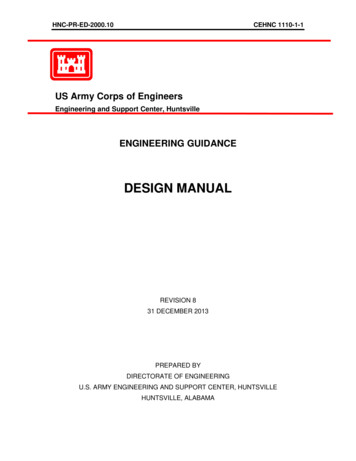
Temporary Access Roads - DownstreamMarti nSloughµProposed Access RoadsTemporary bridgeStream CrossingPondsBasic Design Plans00.050.10.2MilesData Sources: Humboldt County WebGIS; USGS; GHDEXHIBIT 5
Temporary Access Roads - UpstreamMarti nSloughµProposed Access RoadsTemporary bridgeStream CrossingPondsBasic Design Plans0Data Sources: Humboldt County WebGIS; USGS; GHD0.04250.0850.17MilesEXHIBIT 6
Project Staging AreasPG&E Gas Line Decommissioning Staging AreasEXHIBIT 7
Marti nSloughµStaging and Stockpile AreasPost Project FencingStockpile AreasStaging AreasProposed Access RoadsPondsBasic Design PlansData Sources: Humboldt County WebGIS; USGS; GHD00.04250.0850.17MilesEXHIBIT 8a
Marti nSloughµStaging and Stockpile AreasPost Project FencingStockpile AreasStaging AreasProposed Access RoadsPondsBasic Design PlansData Sources: Humboldt County WebGIS; USGS; GHD00.04250.0850.17MilesEXHIBIT 8b
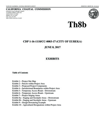
µDewatered SectionIn the most downstream stretch of construction, thebypass pipe will release water into the already existingdrainage ditch which connects to Swain Slough. Inother stretches, the bypass piping will release waterinto the Martin Slough channel downstream of construction.Energy DissipatorPumpsFish ScreenBypass PipeCoffer DamsPump hoseHolding TankProposed Access RoadsPondsBasic Design Plans0100200400FeetThis is an example of how the sections of slough channel will be dewateredand managed during construction. In most cases, no more than 1,000 feet ofchannel will be dewatered at a time. The contractor will decide the locationof the bypass piping, holding tank, and pumps, however the onsite biologist willensure that a minimal amount of fish (if any) will be harmed during construction.Data Sources: Humboldt County WebGIS; USGS; GHDEXHIBIT 9
Figure 6. Agriculture land designations within Martin Slough Enhancement ProjectEXHIBIT 10
Parcel Number APN Landowner Name Acreage 1 305 -021 -011 Vroman 13.