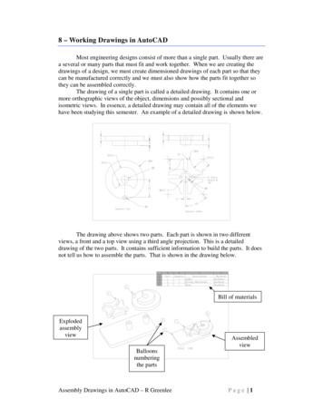
Transcription
CHAPTER 6 - CADD DRAWING STANDARDS AND GUIDELINESSECTIONDESCRIPTION6.01Standard CADD Drawing Levels6.01.01General6.01.02Geographical Type Of Drawings6.01.03Geographical Highway Maps6.01.04Non-Geographical Type Of Drawings6.02CADD Drafting Conventions6.02.01Drafting Guidelines For CADD Contract Plans6.02.02Drafting Guidelines For Other Type of CADD Drawings6.03Highways Font Library6.04Highways Color Table6.05Highways Pen Tables6.06Highways Feature TablesChapter 6-15/16/05
FIGURES6.01.02Highways Division CADD Drawing Levels6.01.03Levels Used for Planning Branch6.02CADD Text Weights, Color, Level, Weight and Font for ContractPlans6.03 AHighway Divison CADD Fonts6.03 BHighways Font Library6.04Highways Division Color TableChapter 6-25/16/05
CHAPTER 6 - CADD DRAWING STANDARDS AND GUIDELINES6.01 Standard CADD Drawing Levels6.01.01 GeneralThe CADD permits the separation of data by levels or layers. Similar types of datashould be drawn on the same level. Each level is analogous to a tracing sheet in manualdrafting; however, with older versions of the CADD file there were 63 different levels orlayers that data could be drawn on. Our current version allows for many more levels.The CADD allows one, all or any combination of levels to be seen at one time. To makeeffective use of the CADD capabilities to create specific drawings by combining certainlevels and to have standardization and uniformity, the CADD drawings created shallfollow the Level Schemes described in the following Subsections. It is very importantthat the elements are placed on the correct levels.6.01.02 Geographical Type of DrawingsGeographical types of drawings are those where the elements are drawn to theiron-ground locations (x & y coordinates for 2-dimensional files and x, y, & z coordinatesfor 3-dimensional files). Geographical drawings can be drawn with actual or assumedcoordinate values.Examples of Geographical types of drawings include topographical survey maps;roadway base maps; roadway, utility, drainage, traffic signal, highway lighting andpavement marking and signing plans; right-of-way maps; easement maps; etc. Generally,geographical oriented maps or plans are created by combining various levels of a basemap or using the base map as an underlay (Reference File). The CADD user shall followthe Level Scheme as shown in Figure 6.01.02 when creating Geographical type ofdrawings.6.01.03 Geographical Highway MapsThe Geographical Highway Maps are those that are created by using the digital UnitedStates Geological Survey maps as the base or underlay (Reference File). The CADD usershall follow the Level Scheme as shown in Figure 6.01.03 when creating GeographicalHighway Maps.6.01.04 Non-Geographical Type of DrawingsNon-geographical types of drawings are those where elements are not drawn to anyspecific on-ground location. Examples include typical sections; cross sections; profiles;detail type of drawings; etc. The CADD user shall follow the Level Scheme as shown inFigure 6.01.02.6.01-1r7/01/08
6.02 CADD Drafting Conventions6.02.01 Drafting Guidelines For CADD Contract PlansThe text and symbology (weight WT, linestyle LC, and color CO) requirements forCADD Contract Plan Sheets have been standardized to provide uniform CADD ContractPlan Drawings throughout the Division. See Figures 6.02 A through D for the CADDDrafting Guidelines for the element symbology and text parameters.6.02.02 Drafting Guidelines For Other Type of CADD DrawingsEach office has developed their own CADD Drafting Standards for other type ofdrawings because of the many different types of drawings created.The Lead Operator will be responsible to document the CADD Drafting Standards usedby his office for these types of drawings and give this information to the CADD Office.6.02-15/16/05
6.03 Highways Font LibraryThe CADD Office has developed a standard Highways Font Library called 'HDOT font.rsc'.The CADD Office will maintain and revise the Highways Font Library. The Lead Operatorshall request the CADD Office to make any revisions or additions to the Highways FontLibrary. The CADD Office may assign the revisions to the Lead Operator if the font isunique to the Lead Operator's office. (See Figures 6.03 A and 6.03 B For The HighwaysFont Library).The Highways Font Library contains special characters, as the baseline, centerline,plus/minus etc. characters that uses certain keys to input. The keys that were used to inputthese special characters will display on the workstation screen; however, when the file isplotted the special characters will be plotted. (See Figure 6.03-B For these specialcharacters).6.03-1r7/01/08
6.04 Highways Color TableThe CADD Office has developed a standard Highways Color Table called 'HDOT color.tbl'.The CADD Office will maintain and revise the Highways Color Table. The Lead Operatorshall request to the CADD Office for any revisions or additions to the Highways ColorTable. The CADD Office will copy the color table to all workstations during softwareupgrades. (See Figure 6.04 For The Highways Color Table).6.04-1r7/01/08
6.05 Highways Pen TablesPen Tables are used to selectively modify elements during the plotting process from howthey were created in the design file. The Pen Table enables the user to change thesymbology (linestyle or weight) of the element in the hardcopy plot. Lines can be modifiedto plot to any user defined linestyle or weight, however the symbology as seen on the CADDmonitor is not changed.Pen Tables are also used to assign pens in the Pen Plotter to a set of criteria, so each elementis plotted by a pen based on the criteria that is set.The Lead Operator may create customized Pen Tables for his office to modify the CADDfiles to meet his office criteria. All Pen Tables shall be reviewed and approved by the CADDOffice. The Lead Operator shall be responsible for maintaining his office's customized PenTables and shall inform the CADD Office of any revisions.6.05-15/16/05
6.06 Highways Feature TablesFeature Tables are used by various types of software to place features (such as roads,utilities, lot lines, etc.) automatically in the design file. Features are graphic elements (lines,shapes, text, symbols, etc.) that are placed in the design file by the software. The FeatureTable tells the software what level, symbology and annotation these graphic elements willlook like.The CADD Office, together with the Highway Design Section and Cadastral Design SectionLead Operators, will create customized Feature Tables for the Division. The CADD Officeshall be responsible for maintaining the Feature Tables. The Lead Operator shall make arequest to the CADD Office for any changes and/or additions to the Feature Tables.6.06-15/16/05
HIGHWAY DIVISION CADD DRAWING LEVELSLEVELDESCRIPTIONWTLCCOLORLevel 1Level 2Level 3Level 4.Level 63Left for importing Microstation J and planning maps.Levels correspond to old Microstation J level numbers.1 BaselineBaseline element & symbol404 (yellow)1 Baseline DCBaseline element & symbol(Cadastral Section)204 (yellow)1 Baseline detailBaseline for contract plans: detailtype drawings500 (white)1 Cl HwyCenter line for highway perContract plans: plan typedrawings400 (white)1 Cl hwy detailCenter line for highway percontract plans: detail typedrawings500 (white)1 Typ sec existExisting typical sections222 (green)1 Typ sec newNew typical sections400 (white)2 Alt BaselineAlternate baseline element &symbol4012 (lt. mustard)2 Alt Baseline DC(Cadastral section)2012 (lt. mustard)3 Text surveyText for survey work400 (white)3 Text existText for existing featuresheight 5/32” font 2720 (white)3 Text newText for new workstructural:height 5/32” font 27others: height 3/16” font 2740 (white)NOTE:* Element is a cell**Color is the same as Type of Easement (i.e. Drain easement is same color as drain)Figure 6.01.02R12/26/18Page 1 of 9
HIGHWAY DIVISION CADD DRAWING LEVELSLEVELDESCRIPTION3 Text subtitleSub-Title TextHeight ¼” font 273 Symb and noteMiscellaneous symbols and notes3 Text main titleWTLCCOLOR60 (white)(cell)(cell)Main title textHeight 5/16” font 2780 (white)3 Text FA blockText in Federal Aid blockHeight 5/32” font 2730 (white)3 Text TB main titleText for title block main title(line 1)Height 1/4” font 27100 (white)3 Text TB limitsText for title block limits (line 2)Height 3/16” font 2760 (white)3 Text TB proj infoText for title block project nameand number (lines 3, 4, & 5)Height 3/16” font 2760 (white)3 Text TB scale dateText for title block scale and dateHeight 5/32” font 2730 (white)3 Text TB sht noText for title block sheet numberHeight 5/32” font 2760 (white)3 Text sht noText for plan sheet numberHeight ” font 2700 (white)4 Hwy struct existExisting highway structures2219 (aqua)5 Hwy struct newNew highway structures4019 (aqua)6 EOP n Shdr existExisting Edge of pavement andshoulders222 (green)7 EOP n Shdr newNew Edge of pavement andshoulders400 (white)8 Curb gut existExisting curb & gutter222 (green)9 Curb gut newNew curb & gutter400 (white)8 Sidewalk existExisting sidewalk222 (green)NOTE:* Element is a cell**Color is the same as Type of Easement (i.e. Drain easement is same color as drain)Figure 6.01.02R12/26/18Page 2 of 9
HIGHWAY DIVISION CADD DRAWING LEVELSLEVELDESCRIPTION9 Sidewalk newNew sidewalk10 ICS TDP idICS, TDP point I.D. numbers11 Misc sym n annotMiscellaneous symbols &annotation12 Cut Fill slopesWTLCCOLOR400 (white)Cut and Fill slopes208 (tan)13 Topo grnd shotTopographic ground shots228 (tan)14 Misc struct existMicellaneous existing structures229 (med. green)14 Misc struct newMiscellaneous new structures409 (med. green)15 Pavt recon limitPavement reconstruction limits400 (white)15 Pavt recon hatchPavement reconstruction hatching100 (white)15 Cold plan limitCold planning limits400 (white)15 Cold plan XhatchCold planning cross-hatching100 (white)16 Constr parcelConstruction Parcel666 (orange)17 Access CtrlAccess Control6use cell1 (blue)18 DC textCadastral section text19 Easements existExisting easements45match type19 EasementsEasements for contract plans:plan type drawings752 (green)20 Land crt existOriginal land court, property lines,and subdivisions002 (green)20 Land crt finalFinal land court, property lines,subdivisions, and remnants202 (green)21 Grants existOriginal grants, land commissionawards and royal patents063 (red)21 Grants finalFinal grants, land commissionawards and royal patents263 (red)20 Prop lineProperty lines for contract plans:plan type drawings462 (green)NOTE:* Element is a cell**Color is the same as Type of Easement (i.e. Drain easement is same color as drain)Figure 6.01.02R12/26/18Page 3 of 9
HIGHWAY DIVISION CADD DRAWING LEVELSLEVELDESCRIPTIONWTLCCOLOR22 ROW existExisting right-of-way (contractplans)461 (blue)22 ROW DCExisting right-of-way (cadastralsection)461 (blue)23 TraverseTraverse020 (white)24 ROW newNew right-of-way (contract plans)461 (blue)24 ROW genROW for contract plans: plan typedrawings561 (blue)24 ROW detailROW for contract plans: detailtype drawings500 (white)24 ROW new DCNew right-of-way (cadastralsection)1201 (blue)24 Easements newNew Easements (cadastralsection)1201 (blue)25 Triang exist surfTriangles for existing surface103 (red)25 Triang new surfTriangles for new surfaces206 (orange)25 Brdr exist surfBorder for existing surface104 (yellow)25 Brdr new surfBorder for new surface2016 (lt blue)30 Cont maj existMajor contours for existingsurface254 (yellow)30 Cont maj newMajor contours for new surface2512 (lt mustard)31Cont min existMinor contours for existingsurface053 (red)31 Cont min newMinor contours for new surfaces0513 (lime)35 Text util symText for utility symbols36 Water existExisting water utilities2416 (very lt. blue)36 Water newNew water utilities4416 (very lt. blue)37 Electric existExisting electrical utilities2424 (orange)NOTE:* Element is a cell**Color is the same as Type of Easement (i.e. Drain easement is same color as drain)Figure 6.01.02R12/26/18Page 4 of 9
HIGHWAY DIVISION CADD DRAWING LEVELSLEVELDESCRIPTIONWTLCCOLOR37 Electric newNew electrical utilities4424 (orange)38 Telephone existExisting telephone utilities2422 (lt. mustard)38 Telephone newNew telephone utilities4422 (lt. mustard)38 Sig corp existExisting signal corp utilities2420 (flesh)38 Sig corp newNew signal corp utilities4420 (flesh)39 Sewer existExisting sewer utilities2423 (blue)39 Sewer newNew sewer utilities4423 (blue)40 Gas existExisting gas utilities248 (tan)40 Gas newNew gas utilities448 (tan)40 Cable existExisting cable utilities2426 (dark pink)40 Cable newNew cable utilities4426 (dark pink)40 Fiberop existNew fiber optic utilities2414 (hot pink)40 Fiberop newNew fiber optic utilities4414 (hot pink)40 Msc util A existExisting miscellaneous utility2415 (lt purple)40 Msc util A newExisting miscellaneous utility4415 (lt purple)40 Msc util B existExisting miscellaneous utility2415 (lt purple)40 Msc util B newExisting miscellaneous utility4415 (lt purple)41 Drain existExisting drain2213 (lt yellow)42 Drain newNew drain4013 (lt yellow)43 Sprinkler existExisting sprinkler system2216 (very lt blue)43 Sprinkler newNew sprinkler system4216 (very lt blue)44 Landscape existExisting landscaping2210 (chartreuse)44 Landscape newNew landscaping4210 ( chartreuse)45 Fence existExisting fence277 (gray)45 Fence newNew fence477 (gray)46 Boundary ptsBoundary points2use cell0 (white)NOTE:* Element is a cell**Color is the same as Type of Easement (i.e. Drain easement is same color as drain)Figure 6.01.02R12/26/18Page 5 of 9
HIGHWAY DIVISION CADD DRAWING LEVELSLEVELDESCRIPTIONWTLCCOLOR48 Grid minorMinor grid lines(cell)(cell)(cell)49 Grid majorMajor grid lines(cell)(cell)(cell)49 Topo H20Topographic water shots (streamslakes, ocean, etc.)2216 (very lt. blue)50 UsersUser discretion51 Pt elevPoint elevations52 St plan grdCadastral State Plane Grids006 (orange)53 Geode grdGeodetic grids003 (red)54 Grdrail existExisting guardrail2325 (lt pink)54 Grdrail newNew guardrail4025 (lt pink)55 Pvt mark existExisting pavement marking204 (yellow)55 Pvt makr newNew pavement marking404 (yellow)56 Traf sign existExisting traffic signs2021 (white)56 Traf sign newNew traffic signs4021 (white)57 Traf signal existExisting traffic signal2220 (flesh)57 Traf signal newNew traffic signal4020 (flesh)58 Hwy light existExisting highway lighting223 (red)58 Hwy light newNew highway lighting403 (red)59 Traf controlTraffic control406 (orange)60 Border shtBorder sheet (cell)61 As-built postAs-built postings4029 (hot pink)62 Half size labelHalf-size label (cell)62 Half size ticksTicks for half-size plans009 (med green)Point infoPoint description, Northing andEasting203 (red)GPSGlobal positioning system233 (red)NOTE:* Element is a cell**Color is the same as Type of Easement (i.e. Drain easement is same color as drain)Figure 6.01.02R12/26/18Page 6 of 9
HIGHWAY DIVISION CADD DRAWING 0 (chartreuse)Mass transitMass Transit2211 (lt pink)Xsect grnd existExisting ground on cross sections322 (blue)Xsect grnd newNew grade on cross sections500 (white)Elev pln grnd existExisting ground on profile orelevation plans322 (green)Elev pln grnd newNew grade on profile or elevationplans500 (white)Conc existConcrete – existing2121 (white)Conc exist hidConcrete – hidden existing2221 (white)Conc newConcrete – new402 (green)Conc new hidConcrete – hidden new422 (green)Metal existMetal – existing2145 (lt purple)Metal exist hidMetal – hidden existing2245 (lt purple)Metal newMetal – new4017 (dark pink)Metal new hidMetal – hidden new4217 (dark pink)Wood existWood – existing2112 (lt mustard)Wood exist hidWood – hidden existing2212 (lt mustard)Wood newWood – new406 (orange)Wood new hidWood – hidden new426 (orange)Grade existGrade – existing2313 (lt lime)Grade exist hidGrade – hidden existing2213 (lt lime)Grade newGrade – new402 (green)Grade new hidGrade – hidden new452 (green)Reinforc existReinforcing – existing3328 (aqua)Reinforc exist hidReinforcing – hidden existing3528 (aqua)NOTE:* Element is a cell**Color is the same as Type of Easement (i.e. Drain easement is same color as drain)Figure 6.01.02R12/26/18Page 7 of 9
HIGHWAY DIVISION CADD DRAWING LEVELSLEVELDESCRIPTIONWTLCCOLORReinforc newReinforcing – new804 (yellow)Reinforc new hidReinforcing – hidden new854 (yellow)PMJF existPremolded joint filler – existing217 (gray)PMJF exist hidPremolded joint filler – hiddenexisting227 (gray)PMJF newPremolded joint filler – new4011 (lt pink)PMJF new hidPremolded joint filler – hiddennew4211 (lt pink)Plas blk existPlastic block – existing2110 (chartureuse)Plas blk exist hidPlastic block – hidden existing2210 (chartueruse)Plas blk newPlastic block – new4015 (lt purple)Plas blk new hidPlastic block – hidden new4215 (lt purple)Saw cutSaw cut – new202 (green)Saw cut hidSaw cut – hidden new222 (green)Lim remLimits of removal – new409 (med green)Lim rem hidLimits of removal – hidden new429 (med green)SpaceVoid areas2121 (white)Space hidHidden void areas2230 (gray)CrackCrack804 (yellow)Crack hidHidden crack824 (yellow)Conc jointConcrete joints502 (green)Dim linesDimension and leader lines200 (white)Dim textDimension text4text0 (white)Break lineBreak line200 (white)Cl det 3/8Centerline for detail 3/8” dash2421 (white)Cl det 1Centerline for detail 1” dash240 (white)NOTE:* Element is a cell**Color is the same as Type of Easement (i.e. Drain easement is same color as drain)Figure 6.01.02R12/26/18Page 8 of 9
HIGHWAY DIVISION CADD DRAWING LEVELSLEVELDESCRIPTIONWTLCCOLORCl det 5Centerline for detail 5” dash245 (flesh)Cl detCenter line for detail200 (white)Section lineSection line600 (white)Section lineSection line dor contract plans:detail dtype drawings500 (white)WeldWeld symbol400 (white)Pattern existExisting fill patterns0014 (hot pink)Pattern newNew fill patterns2017 (drk pink)CloudCloud for changes800 (white)Match lineMatch line600 (white)Drain stl cvr newNew steel drain cover4047 (lt. blue)Drain stl cvr existExisting steel drain cover4047 (lt. blue)Drain fill matl newNew drainage fill material(cell)(cell)(cell)Drain fill matl existExisting drainage fill material(cell)(cell)(cell)Jnt compJoint Compound5014 (hot pink)AC newNew structural AC work403 (red)AC existExisting structural AC work203 (red)PVC newNew structural PVC work4015 (lt purple)PVC existExisting PVC work2015 (lt purple)PhotogrammetryPoint Clouds, Lidar, etcNOTE:* Element is a cell**Color is the same as Type of Easement (i.e. Drain easement is same color as drain)Figure 6.01.02R12/26/18Page 9 of 9
LEVELS USED FOR PLANNING BRANCH1 . INTERSTATE ROAD SYSTEMCO 3, WT 1, LC 7, CPK 30'(TOTAL WIDTH 60')A-DIVIDED HWY. BY CENTERLINE OR BARRIER, CPK 75'(TOTAL WIDTH 150')B-DIVIDED HWY. BY MEDIAN, CPK 60'(MEI)IAN WIDTH 30') (TOTAL WIDTH150'TREES & LANDSCAPING)C-RAMPS CPK 20'(TOTAL WIDTH 40')D-INTERCHANGES BETWEEN INCOMING & OUTGOING VIADUCTS, CPK 15'2 . INTERSTATE ROAD SYSTEM CENTER LINECO 3, WT 1, LC 7,CREATED WITH AUTO CHAIN3 . FAP HIGHWAYS/FREEWAYS & EXPRESSWAYCO 25(COLOR DISPLAY SAME AS CO 11),WT 1,LC 7CPK 30'(TOTAL WIDTH 60')A-DIVIDED HWY. BY CENTERLINE OR BARRIER,CPK 75'(TOTAL WIDTH 150')B-DIVIDED HWY. BY MEDIAN,CPK 60'(MEDIAN WIDTH 30')(TOTAL WIDTH 150'-TREES & LANDSCAPING)4 . FAP HIGHWAYS/FREEWAY & EXPRESSWAY CENTER LINECO 25(COLOR DISPLAY SAME AS CO 1),WT 1,LC 7CREATED WITH AUTO CHAIN5 . FAS HIGHWAYS/PRINCIPAL ARTERIALCO 26(COLOR DISPLAY SAME AS CO 17),WT 1,LC 7CPK 30(TOTAL WIDTH 60')A-DIVIDED HWY. BY CENTERLINE OR BARRIER,CPK 75'(TOTAL WIDTH 150,)B-DIVIDED HWY. BY MEDIAN,CPK 60'(MEDIAN WIDTH 30')(TOTAL WIDTH 150'-TREES & LANDSCAPING)6 . FAS HIGHWAYS/PRINCIPAL ARTERIAL CENTER LINECO 26(COLOR DISPLAY SAME AS CO 17),WT 1,LC 7CREATED WITH AUTO CHAIN7 . FASC HIGHWAYS/MINOR ARTERIALCO 0, WT 1, LC 7, CPK 30'(TOTAL WIDTH 60')A-DIVIDED HWY. BY CENTERLINE OR BARRIER CPK 75'(TOTAL WIDTH 150')B-DIVIDED HWY. BY MEDIAN,CPK 60'(MEDIAN WIDTH 30')(TOTAL WIDTH 150'-TREES & LANDSCAPING)8 . FASC/MINOR ARTERIAL CENTER LINECO O,WT 1,LC 7,CREATED WITH AUTO CHAIN9 . FAU HIGHWAYS/MAJOR COLLECTORCO 19(COLOR DISPLAY SAME AS CO 28),WT 1,LC 7CPK 20'(TOTAL WIDTH 40')10 . FAU HIGHWAYS/MAJOR COLLECTOR CENTER LINECO 19(COLOR DISPLAY SAME AS CO 28),WT 1,LC 7CREATED WITH AUTO CHAINFigure 6.01.035/16/05page 1 of 5
LEVELS USED FOR PLANNING BRANCH11 . MINOR COLLECTORCO 15,WT 1,LC 7,CPK 30'(TOTAL WIDTH 60')A-DIVIDED HWY. BY CFNTERLINE OR BARRIER,CPK 75'(TOTAL WIDTH 150')B-DIVIDED HWY. BY MEDIAN,CPK 60'(MEDIAN WIDTH 30')12 . MINOR COLLECTOR CENTER LINECO 15, WT 1 LC 7, CREATE WITH AUTO CHAIN13 . STATE HIGHWAY SYSTEM TEXTTH 150',TW 150',LS 75',FT 29,WT O,CO 3(lv l),25(lv 3),26(lv 5),O(lv 7),19(lv 9),15(lv ll)14 . COUNTY ROAD SYSTEMCO 4, WT 0, LC 0, CPK 20'(TOTAL WIDTH 40'),DIRT ROAD/ PRIMITIVE(LC 2)15 . TEXT COUNTY ROAD SYSTEMTH 100', TW 100', LS 50', FT 29, CO 4, WT 016 . COUNTY ROAD SYSTEM CENTER LINEWT O,LC O,CO 4, PRIMITIVE (LC 2) CREATED WITH AUTO CHAIN17 . PROPOSED STATE HIGHWAYSCO 25, WT 1, CPK 30'(TOTAL WIDTH 60'), LC 1A-DIVIDED HWY. BY CENTERLINE OR BARRIER, CPK 75'(TOTAL WIDTH 150')B-DIVIDED HWY. BY MEDIAN,CPK 60'(MEDIAN WIDTH 30')18 . TEXT PROPOSED STATE HIGHWAYSTH 150',TW 150',LS 75',FT 29CO 25(COLOR DISPLAY SAME AS CO 11),WT O19 . REVISED ROAD UPDATE[) (ALL NEW ROAD ELEMENTS)PLACED ACCORDING TO RESPECTIVE COLORSCO 3,25,26,0,19,15,420 . SHORELINECO I, WT l, LC O21 . TEXT SHORELINECO l, WT O, FT 45BAYS-TH 250', TW 250', LS 125'OCEAN-TH 600', TW 600', LS 300'22 . STREAMSCO I,WT O,LC O,(INTERMITTENT STREAMS CO 18,WT O,LC 2)FLUME BRACKET(AS LINE TERMINATOR)30'@ 45 DEGREESWATER TUNNEL BRACKET (AS LINE TERMINATOR)30'@ 45 DEGREESFigure 6.01.035/16/05page 2 of 5
LEVELS USED FOR PLANNING BRANCH23 . TEXT STREAMSTH 125', TW 125', LS 100', FT 45, CO 1, WT 0CHAR. SPACING 50'UPPER & LOWER CASE24 . LAKES/PONDS (SHAPE)CO l, WT O, LC O25 . TEXT LAKESTH 150', TW 150', LS 75', FT 45, CO 1, WT 026 . BRIDGES/OVERPASS/UNDERPASS USING APPROPRIATE CELLS27 . VACANT28 . VACANT29 . TEXT CITIES/TOWNSTH 200', TW 200', LS 100', FT 29, CO 0, WT 0CITIES UPPER CASE,TOWNS LOWER CASE30 . TEXT CULTURAL FEATURESTH 125', TW 125', LS 50', FT 29, CO 0, WT 0UPPER & LOWER CASE31 . VACANT32 . PARTIAL ADJUSTED & URBANIZED AREA BOUNDARYCO 12, WT 3, LC 5(ADJUSTED), LC 6(URBANIZED)CPK 100'FROM ANY OTHER BOUNDARY OR LINE33 . CENSUS URBAN BOUNDARYCO 10, VV7 3, LC 4CPK 100'FROM ANY OTHER BOUNDARY OR LINE34 . ADJUSTED & URBANIZED AREA BOUNDARYCO 29(COLOR DISPLAY SAME AS CO- 14),WT 3LC 4(ADJUSTED BOUNDARY),LC 6(URBANIZED AREA BOUNDARY)CPK 100'FROM ANY OTHER BOUNDARY OR LINE35 . TEXT CENSUS BOUNDARYTH 200', TW 200', LS 100', FT 29CO 29(COLOR DISPLAY SAME AS CO 14),WT O36 . DISTRICT BOUNDARYCO 6(COLOR DISPLAY SAME AS CO 24),WT 3,LC 337 . TEXT DISTRICT BOUNDARY LINETH 200', TW 250', LS 150', FT 29, CO 6, WT 0, CHAR. SPACING 50’DISTRICT AREA (TH 250',TW 750',LS 200',FT 29,CO 6,WT O)Figure 6.01.035/16/05page 3 of 5
LEVELS USED FOR PLANNING BRANCH38 . FOREST BOUNDARYCO 2, WT 0, LC 039 . TEXT FOREST BOUNDARYTH 200', TW 250', LS 100', FT 29, CO 2, WT 040 . FOREST SHAPECO 6, WT 0, LC 0, AP DOT3, PD 50',50'41 . MILITARY BOUNDARYCO 8, WT O, LC O42 . TEXT MILITARY BOUNDARYTH 200', TW 250', LS 100', FT 29, CO 8, WT 0ORTH 100', TW 100', LS 50', FT 29, CO 8, WT 043 . MILITARY SHAPECO 6, WT 0, LC 0, AP DOT2, PD 100',100'44 . GRID TICKS(SHEET BORDER/FRAME)CO 0, WT O, LC 045 . COORDINATE GRID TEXTTH 150', TW 150', LS 75', FT 1, CO 0, WT 0SHEET TITLETH 1000', TW 1000', LS 500', FT 43, CO 0, WT 046 . 1:1000 SCALE GRIDCO WT 47 . 1:2000 SCALE GRIDCO WT 48 . 1:3000 SCALE GRIDCO WT 49 . CONTOURSCO 23(COLOR DISPLAY SAME AS CO 1),WT 050 - USER LEVELALL ELEMENTS USER DOES NOT WANT PLOTTED OUTCOMPLETE PATH/FILE NAME LOWER RIGHT OF PLOT SHEETFT 0, CO 3, WT 1, TX 400'(2000 SCALE)51 . CONTROL POINTS FOR DIGITIZINGCO 20, WT 10Figure 6.01.035/16/05page 4 of 5
LEVELS USED FOR PLANNING BRANCH52 - LANDING STIP/AIRPORT & PERIMETERCO 27(COLOR DISPLAY SAME AS CO 18),WT 053 . VACANT54 . RAILROADCO 20,WT 055 . URBAN MAP/FUNCTIONAL CLASSIFICATION MAP TEXT56 . VACANT57 . VACANT58 . VACANT59 . VACANT60 . BORDER CELL61 . VACANT62 . VACANT63 . DO NOT USEFigure 6.01.035/16/05page 5 of 5
CADD TEXT WEIGHTS, COLOR, LEVEL, WEIGHT AND FONTFOR CONTRACT PLANSDESCRIPTIONWEIGHT COLOR LEVEL HEIGHTFONTExisting Features2*03**3/16"***27Planned ConstructionFeatures (New Work)403**3/16"***27Sub-Titles603**1/4"27Main Titles803**5/16"27F.A. Block303**5/32"271003**1/4"27Limits (Line 2)603**3/16"27Project Name & No.(lines 3,4 & 5)603**3/16"27Scale/Date303**5/32"27Sheet No.603**5/32"27003**3/8"30Title BlockMain Title (Line 1)Plan Sheet No.NOTE :*Text weight for existing features may be same as new work.**Levels 1 & 2 may also be used for Text as determined by each Section*** HWY-DB and HWY-DH Text Height 5/32"Figure 6.025/16/05
HIGHWAYS DIVISION CADD FONTSAll character fonts are stick fonts unless TYPE is designated as BIT. BIT fonts are lowresolution bit stream fonts (filled font000MOD WORKINGAS BUILTUSTN ENGNRGSHADOWSCRIPTDOTTEDfont007SCRIPT2font026HDOT STANDARDCADASTRAL RW LCSWISS 722 L LSWISS 722 LSWISS 722 B LINTERNAT.CELSWISS 722 LI LSWISS 722 I LSWISS 722 BI Lfont041OUTLINEALDINE 401 LALDINE 401 B LALDINE 401 I LALDINE 401 BI LBLACKLETTER 651 LDESCRIPTIONSTANDARDUSTN WORKING (modified)FANCY FONT (modified)Hawaiian Alphabet (HWY-DC)Ribbon 131(HWY-DC)COMPRESSEDLowercase (HWY)GREEKITALICS (modified) HIGHWAYS Standard fontITALICS (modified) HWY-DC R/W and LC Map(modified), HWY Leroy Std(modified), HWY Leroy Std(modified), HWY Leroy StdARCHITECTURALGEOMETRICFUTURA 211 L LGEOMETRICFUTURA 211 M Lfont050SWISS 721 BO LICS MODSURSYMTDP SIGNSTDP SURF PNTSTDP PLANTSTDP ALN PNTSfont127Total Character Fonts:Total Symbol Fonts:UPPERCASEfast font375Figure 6.03 A5/16/05
HIGHWAYS DIVISION COLOR m green851858510chartreuse1852558511light pink25515518512light mustard25520010013light yellow23525514514hot pink2553518515light purple17517525516very light blue18025525517dark pink2055015018very light pink25521525519aqua024517020flesh235185185Figure 6.04r7/01/08Page 1 of 4
HIGHWAYS DIVISION COLOR TABLENUMBERCOLORREDGRNBLUE21white20520520522light ght pink25515518526dark pink2055015027very light pink25521525528aqua024517029hot ange2551105037gray15015015038tan1851358539medium green851858540chartreuse18525585Figure 6.04r7/01/08Page 2 of 4
HIGHWAYS DIVISION COLOR TABLENUMBERCOLORREDGRN41mustard204204042light mustard25520010043light yellow23525514544egg shell25525520545light purple17517525546very light blue18025525547light blue020025548light 858555light pink25515518556dark pink2055015057very light pink25521525558pink25514025559hot pink2553518560white205205205Figure 6.04r7/01/08BLUEPage 3 of 4
HIGHWAYS DIVISION COLOR TABLENUMBERCOLORHighlightbright whiteREDGRNBLUE255255255For Contract Plan Drawings, DO NOT use colors 14 & 29. These colors will be reserved forposting as-built drawings.The following colors have the same 6574951,60 -----white------ blue------ green------ red------ yellow------ flesh------ orange------ gray------ tan------ medium green------ chartreuse------ light pink------ light mustard------ light lime------ hot pink------ light purple------ very light blue------ dark pink------ very light pink------ aqua------ whiteFigure 6.04r7/01/08Page 4 of 4
HIGHWAYS DIVISION PRINTING COLOR TABLENUMBERCOLOR0black 5004mustard (yellow)17317305dark mauve (flesh)1811431436dark orange (orange)20490417gray1501501508dark brown (tan)185135859forest green (medium green)471024710dark lime (chartreuse)1271765811light pink25515518512light mustard25520010013light yellow23525514514hot pink2553518515light purple17517525516very light blue18025525517dark pink2055015018very light pink25521525519aqua024517020flesh235185185Figure 6.04r7/01/08Page 5 of 4
HIGHWAYS DIVISION PRINTING COLOR TABLENUMBERCOLORREDGRNBLUE21white20520520522light ght pink25515518526dark pink2055015027very light pink25521525528aqua024517029hot ange2551105037gray15015015038tan1851358539medium green851858540chartreuse18525585Figure 6.04r7/01/08Page 6 of 4
HIGHWAYS DIVISION PRINTING COLOR TABLENUMBERCOLORREDGRN41mustard204204042light mustard25520010043light yellow23525514544egg shell25525520545light purple17517525546very light blue18025525547light blue020025548light 858555light pink25515518556dark pink2055015057very light pink25521525558pink25514025559hot pink2553518560white205205205Figure 6.04r7/01/08BLUEPage 7 of 4
CHAPTER 6 - CADD DRAWING STANDARDS AND GUIDELINES 6.01 Standard CADD Drawing Levels 6.01.01 General The CADD permits the separation of data by levels or layers. Similar types of data should be drawn on the same le