Transcription
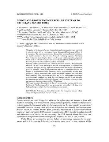
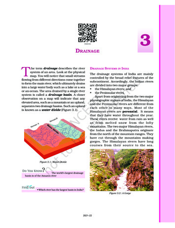
3DRAINAGEThe term drainage describes the riversystem of an area. Look at the physicalmap. You will notice that small streamsflowing from different directions come togetherto form the main river, which ultimately drainsinto a large water body such as a lake or a seaor an ocean. The area drained by a single riversystem is called a drainage basin. A closerobservation on a map will indicate that anyelevated area, such as a mountain or an upland,separates two drainage basins. Such an uplandis known as a water divide (Figure 3.1).mAamtreeaSSrBBammtreeaSSrWaterDivideDRAINAGE SYSTEMS IN INDIAThe drainage systems of India are mainlycontrolled by the broad relief features of thesubcontinent. Accordingly, the Indian riversare divided into two major groups: the Himalayan rivers; and the Peninsular rivers.Apart from originating from the two majorphysiographic regions of India, the Himalayanand the Peninsular rivers are different fromeach other in many ways. Most of theHimalayan rivers are perennial. It meansthat they have water throughout the year.These rivers receive water from rain as wellas from melted snow from the loftymountains. The two major Himalayan rivers,the Indus and the Brahmaputra originatefrom the north of the mountain ranges. Theyhave cut through the mountains makinggorges. The Himalayan rivers have longcourses from their source to the sea.Figure 3.1 : Water DivideThe world’s largest drainagebasin is of the Amazon river Which river has the largest basin in India?Figure 3.2 : A Gorge2021–22
They perform intensive erosional activity intheir upper courses and carry huge loads ofsilt and sand. In the middle and the lowercourses, these rivers form meanders, oxbowlakes, and many other depositional featuresin their floodplains. They also have welldeveloped deltas (Figure 3.3).The Himalayan RiversThe major Himalayan rivers are the Indus, theGanga and the Brahmaputra. These rivers arelong, and are joined by many large andimportant tributaries. A river alongwith itstributaries may be called a river system.The Indus River SystemThe river Indus rises in Tibet, near LakeMansarowar. Flowing west, it enters India in theLadakh. It forms a picturesque gorge in thispart. Several tributaries, the Zaskar, the Nubra,the Shyok and the Hunza, join it in the Kashmirregion. The Indus flows through Baltistan andGilgit and emerges from the mountains at Attock.The Satluj, the Beas, the Ravi, the Chenab andthe Jhelum join together to enter the Indus nearMithankot in Pakistan. Beyond this, the Indusflows southwards eventually reaching theArabian Sea, east of Karachi. The Indus plainhas a very gentle slope. With a total length of2900 km, the Indus is one of the longest riversof the world. A little over a third of the Indusbasin is located in India Ladakh, Jammu andKashmir, Himachal Pradesh and Punjab and therest is in Pakistan.Source of RiverUpper CourseMiddle CourseMeanderOx-Bow LakeLowerCourseDeltaFigure 3.3 : Some Features Made by RiversA large number of the Peninsular rivers areseasonal, as their flow is dependent on rainfall.During the dry season, even the large rivershave reduced flow of water in their channels.The Peninsular rivers have shorter andshallower courses as compared to theirHimalayan counterparts. However, some ofthem originate in the central highlands and flowtowards the west. Can you identify two suchlarge rivers? Most of the rivers of peninsularIndia originate in the Western Ghats and flowtowards the Bay of Bengal. According to the regulationsof the Indus Water Treaty (1960), India canuse only 20 per cent of the total water carried bythe Indus river system. This water is used forirrigation in Punjab, Haryana and the southernand the western parts of Rajasthan.The Ganga River SystemThe headwaters of the Ganga, called the‘Bhagirathi’ is fed by the Gangotri Glacier andjoined by the Alaknanda at Devaprayag inUttarakhand. At Haridwar, the Ganga emergesfrom the mountains on to the plains.18CONTEMPORARY INDIA-I2021–22
Figure 3.4 : Major Rivers and LakesDRAINAGE192021–22
the northernmost point of the Ganga delta. Theriver bifurcates here; the Bhagirathi-Hooghly(a distributary) flows southwards through thedeltaic plains to the Bay of Bengal. Themainstream, flows southwards intoBangladesh and is joined by the Brahmaputra.Further downstream, it is known as theMeghna. This mighty river, with waters fromthe Ganga and the Brahmaputra, flows intothe Bay of Bengal. The delta formed by theserivers is known as the Sundarban Delta.Figure 3.5 : Confluence of Bhagirathi and Alaknanda atDevaprayagThe Ganga is joined by many tributariesfrom the Himalayas, a few of them being majorrivers, such as the Yamuna, the Ghaghara, theGandak and the Kosi. The river Yamuna risesfrom the Yamunotri Glacier in the Himalayas.It flows parallel to the Ganga and as a rightbank tributary meets the Ganga at Allahabad.The Ghaghara, the Gandak and the Kosi risein the Nepal Himalaya. They are the rivers,which flood parts of the northern plains everyyear, causing widespread damage to life andproperty, whereas, they enrich the soil foragricultural use.The main tributaries, which come from thepeninsular uplands, are the Chambal, theBetwa and the Son. These rise from semi-aridareas, have shorter courses and do not carrymuch water in them. Find out where and howthey ultimately join the Ganga. The Namami Gange Programmeis an Integrated Conservation Mission approved asa ‘flagship programme’ by the Union Governmentin June 2014 to accomplish the twin objectives ofeffective abatement of pollution, conservation andrejuvenation of the national river, Ganga. You mayexplore about this project at http://nmcg.nic.in/NamamiGanga.sspx# The Sundarban Delta derivedits name from the Sundari tree, which grows wellin marshland. It is the world’s largest and fastest growing delta.It is also the home of Royal Bengal tiger.The length of the Ganga is over 2500 km.Look at Figure 3.4; can you identify the type ofdrainage pattern formed by the Ganga riversystem? Ambala is located on the water dividebetween the Indus and the Ganga river systems.The plains from Ambala to the Sunderbanstretch over nearly 1800 km, but the fall in itsslope is hardly 300 metres. In other words, thereis a fall of just one metre for every 6 km.Therefore, the river develops large meanders.The Brahmaputra River SystemThe Brahmaputra rises in Tibet east ofMansarowar lake very close to the sources ofthe Indus and the Satluj. It is slightly longerthan the Indus, and most of its course liesoutside India. It flows eastwards parallel tothe Himalayas. On reaching the NamchaBarwa (7757 m), it takes a ‘U’ turn and entersIndia in Arunachal Pradesh through a gorge.Here, it is called the Dihang and it is joined bythe Dibang, the Lohit, and many othertributaries to form the Brahmaputra in Assam.Enlarged with the waters from its right andleft bank tributaries, the Ganga flowseastwards till Farakka in West Bengal. This is20 Brahmaputra is known asthe Tsang Po in Tibet and Jamuna in Bangladesh.CONTEMPORARY INDIA-I2021–22
In Tibet, the river carries a smaller volume ofwater and less silt as it is a cold and a dry area.In India, it passes through a region of highrainfall. Here the river carries a large volume ofwater and considerable amount of silt. TheBrahmaputra has a braided channel in its entirelength in Assam and forms many riverine islands.Do you remember the name of the world’s largestriverine island formed by the Brahmaputra?Every year during the rainy season, theriver overflows its banks, causing widespreaddevastation due to floods in Assam andBangladesh. Unlike other north Indian rivers,the Brahmaputra is marked by huge depositsof silt on its bed causing the riverbed to rise.The river also shifts its channel frequently.The Peninsular RiversThe main water divide in Peninsular India isformed by the Western Ghats, which runs fromnorth to south close to the western coast. Mostof the major rivers of the Peninsula, such asthe Mahanadi, the Godavari, the Krishna andthe Kaveri flow eastwards and drain into theBay of Bengal. These rivers make deltas attheir mouths. There are numerous smallstreams flowing west of the Western Ghats.The Narmada and the Tapi are the only longrivers, which flow west and make esturies. Thedrainage basins of the peninsular rivers arecomparatively smaller in size.The Narmada BasinThe Narmada rises in the Amarkantak hillsin Madhya Pradesh. It flows towards the westin a rift valley formed due to faulting. On itsway to the sea, the Narmada creates manypicturesque locations. The ‘Marble rocks’,near Jabalpur, where the Narmada flowsthrough a deep gorge, and the ‘Dhuadharfalls, where the river plunges over steep rocks,are some of the notable ones. The Narmada riverconservation mission has been undertaken by thegovernment of Madhya Pradesh by a scheme namedNamami Devi Narmade. You may visit their website.http://www.namamidevinarmade.mp.gov.in tolearn more about it.All tributaries of the Narmada are very shortand most of these join the main stream at rightangles. The Narmada basin covers parts ofMadhya Pradesh and Gujarat.The Tapi BasinThe Tapi rises in the Satpura ranges, in theBetul district of Madhya Pradesh. It also flowsin a rift valley parallel to the Narmada but it ismuch shorter in length. Its basin covers partsof Madhya Pradesh, Gujarat and Maharashtra.The coastal plains between Western Ghatsand the Arabian Sea are very narrow. Hence,the coastal rivers are short. The main westflowing rivers are Sabarmati, Mahi,Bharathpuzha and Periyar. Find out the statesin which these rivers drain the water.The Godavari BasinThe Godavari is the largest Peninsular river. Itrises from the slopes of the Western Ghats inthe Nasik district of Maharashtra. Its length isabout 1500 km. It drains into the Bay of Bengal.Its drainage basin is also the largest among thepeninsular rivers. The basin covers parts ofMaharashtra (about 50 per cent of the basinarea lies in Maharashtra), Madhya Pradesh,Odisha and Andhra Pradesh. The Godavari isjoined by a number of tributaries, such as thePurna, the Wardha, the Pranhita, the Manjra,the Wainganga and the Penganga. The last threetributaries are very large. Because of its lengthand the area it covers, it is also known as theDakshin Ganga.The Mahanadi BasinThe Mahanadi rises in the highlands ofChhattisgarh. It flows through Odisha to reachDRAINAGE212021–22
the Bay of Bengal. The length of the river isabout 860 km. Its drainage basin is shared byMaharashtra, Chhattisgarh, Jharkhand,and Odisha.The Krishna BasinRising from a spring near Mahabaleshwar, theKrishna flows for about 1400 km and reachesthe Bay of Bengal. The Tungabhadra, theKoyana, the Ghatprabha, the Musi and theBhima are some of its tributaries. Its drainagebasin is shared by Maharasthra, Karnatakaand Andhra Pradesh.The Kaveri BasinThe Kaveri rises in the Brahmagri range of theWestern Ghats and it reaches the Bay of Bengalin south of Cuddalore in Tamil Nadu. The totallength of the river is about 760 km. Its maintributaries are Amravati, Bhavani, Hemavatiand Kabini. Its basin drains parts of Karnataka,Kerala and Tamil Nadu. The river Kaveri makes thesecond biggest waterfall in India, known asShivasamudram Falls. The hydroelectric powergenerated from the falls is supplied to Mysuru,Bengaluru and the Kolar Gold Field. The name of the biggest waterfallin India.Besides these major rivers, there are somesmaller rivers flowing towards the east. TheDamoder, the Brahmani, the Baitarni and theSubarnrekha are some notable examples.Locate them in your atlas. 71 per cent of the world’ssurface is covered with water, but 97 per cent ofthat is salt water. Of the 3 per cent that is available as freshwater,three quarters of it is trapped as ice.Imagine that if Srinagar, Nainital and othertourists places did not have a lake would theyhave been as attractive as they are today? Haveyou ever tried to know the importance of lakesin making a place attractive to tourists? Apartfrom attraction for tourists, lakes are also usefulto human beings in many ways. Lakes of large extent are called seas,like the Caspian, the Dead and the Aral seas.India has many lakes. These differ fromeach other in size and other characteristics.Most lakes are permanent; some contain wateronly during the rainy season, like the lakes inthe basins of inland drainage of semi-aridregions. There are some lakes which are theresult of the action of glaciers and ice sheets,while others have been formed by wind, riveraction and human activities.A meandering river across a floodplainforms cut-offs that later develops into ox-bowlakes. Spits and bars form lagoons in thecoastal areas, e.g. the Chilika lake, the Pulicatlake and the Kolleru lake. Lakes in the regionof inland drainage are sometimes seasonal; forexample, the Sambhar lake in Rajasthan, whichis a salt water lake. Its water is used forproducing salt.Most of the freshwater lakes are in theHimalayan region. They are of glacial origin.In other words, they formed when glaciersdug out a basin, which was later filled withsnowmelt. The Wular lake in Jammu andKashmir, in contrast, is the result of tectonicactivity. It is the largest freshwater lake inIndia. The Dal lake, Bhimtal, Nainital, Loktakand Barapani are some other importantfreshwater lakes.LAKESYou may be familiar with the valley of Kashmirand the famous Dal Lake, the house boats andshikaras, which attract thousands of touristsevery year. Similarly, you may have visitedsome other tourist spot near a lake and enjoyedboating, swimming and other water games.22Figure 3.6 : Loktak LakeCONTEMPORARY INDIA-I2021–22
Apart from natural lakes, the damming ofthe rivers for the generation of hydel power hasalso led to the formation of lakes, such as GuruGobind Sagar (Bhakra Nangal Project).National River Conservation Plan(NRCP)The river cleaning programme in thecountry was initiated with the launchingof the Ganga Action Plan (GAP)in 1985. The Ganga Action Plan wasexpanded to cover other rivers under theNational River Conservation Plan(NRCP) in the year 1995. The objectiveof the NRCP is to improve the waterquality of the rivers, which are majorwater sources in the country, throughthe implementation of pollultionabatement work.Source: http://nrcd.nic.in/nrcp.pd as on25.07.17ActivityMake a list of natural and artificiallakes with the help of the atlas.Lakes are of great value to human beings.A lake helps to regulate the flow of a river.During heavy rains, it prevents flooding andduring the dry season, it helps to maintainan even flow of water. Lakes can also be usedfor developing hydel power. They moderate theclimate of the surroundings; maintain theaquatic ecosystem, enhance natural beauty,help develop tourism and provide recreation.ROLE OF RIVERS IN THE ECONOMYRivers have been of fundamental importancethroughout the human history. Water fromrivers is a basic natural resource, essentialfor various human activities. Therefore,riverbanks have attracted settlers from ancienttimes. These settlements have now become bigcities. Make a list of cities in your state whichare located on the bank of a river.Using rivers for irrigation, navigation,hydro-power generation is of specialsignificance — particularly to a country likeIndia, where agriculture is the major sourceof livelihood of the majority of its population.RIVER POLLUTIONThe growing domestic, municipal, industrialand agricultural demand for water from riversnaturally affects the quality of water. As aresult, more and more water is being drainedout of the rivers reducing their volume. On theother hand, a heavy load of untreated sewageand industrial effluents are emptied into therivers. This affects not only the quality of waterbut also the self-cleansing capacity of the river.For example, given the adequate streamflow,the Ganga water is able to dilute and assimilatepollution loads within 20 km of large cities.But the increasing urbanisation andindustrialisation do not allow it to happen andthe pollution level of many rivers has beenrising. Concern over rising pollution in ourrivers led to the launching of various actionplans to clean the rivers. Have you heard aboutsuch action plans? How does our health getaffected by polluted river water? Think about“life of human beings without fresh water”.Arrange a debate on this topic in the class.EXERCISE1. Choose the right answer from the four alternatives given below.(i) In which of the following states is the Wular lake located?(a) Rajasthan(c) Punjab(b) Uttar Pradesh(d) Jammu and KashmirDRAINAGE232021–22
(ii) The river Narmada has its source at(a) Satpura(c) Amarkantak(b) Brahmagiri(d) Slopes of the Western Ghats(iii) Which one of the following lakes is a salt water lake?(a) Sambhar(c) Wular(b) Dal(d) Gobind Sagar(iv) Which one of the following is the longest river of the Peninsular India?(a) Narmada(c) Godavari(b) Krishna(d) Mahanadi(v) Which one amongst the following rivers flows through a rift valley?(a) Mahanadi(c) Krishna(b) Tungabhadra(d) Tapi2. Answer the following questions briefly.(i) What is meant by a water divide? Give an example.(ii) Which is the largest river basin in India?(iii) Where do the rivers Indus and Ganga have their origin?(iv) Name the two headstreams of the Ganga. Where do they meet to form the Ganga?(v) Why does the Brahmaputra in its Tibetan part have less silt, despite alonger course?(vi) Which two Peninsular rivers flow through trough?(vii) State some economic benefits of rivers and lakes.3. Below are given names of a few lakes of India. Group them under two categories– natural and created by human d r(j)Rana Pratap SagarNizam Sagar(l)PulicatNagarjuna Sagar(n)Hirakund4. Discuss the significant difference between the Himalayan and the Peninsularrivers.5. Compare the east flowing and the west flowing rivers of the Peninsular plateau.6. Why are rivers important for the country’s economy?Map Skills(i)On an outline map of India mark and label the following rivers: Ganga,Satluj, Damodar, Krishna, Narmada, Tapi, Mahanadi, and Brahmaputra.(ii)On an outline map of India mark and label the following lakes: Chilika,Sambhar, Wular, Pulicat, Kolleru.24CONTEMPORARY INDIA-I2021–22
Project/ActivitySolve this crossword puzzle with the help of given clues.Across1.2.3.4.5.6.7.8.Nagarjuna Sagar is a river valley project. Name the river?The longest river of India.The river which originates from a place known as Beas Kund.The river which rises in the Betul district of MP and flows westwards.The river which was known as the “Sorrow” of West Bengal.The river on which the reservoir for Indira Gandhi Canal has been built.The river whose source lies near Rohtang Pass.The longest river of Peninsular India?Down9.10.11.12.13.14.15.A tributary of Indus originating from Himachal Pradesh.The river flowing through fault, drains into the Arabian Sea.A river of south India, which receives rainwater both in summer and winter.A river which flows through Ladakh, Gilgit and Pakistan.An important river of the Indian desert.The river which joins Chenab in Pakistan.A river which rises at Yamunotri glacier.DRAINAGE252021–22
of the world. A little over a third of the Indus basin is located in India Ladakh, Jammu and Kashmir, Himachal Pradesh and Punjab and the rest is in Pakistan. According to the regulations of the Indus Water Treaty (1960), India can use only 20 per cent of the total water