Transcription
Nat. Hazards Earth Syst. Sci., 20, 2379–2395, 2020https://doi.org/10.5194/nhess-20-2379-2020 Author(s) 2020. This work is distributed underthe Creative Commons Attribution 4.0 License.A spaceborne SAR-based procedureto support the detection of landslidesGiuseppe Esposito1 , Ivan Marchesini2 , Alessandro Cesare Mondini2 , Paola Reichenbach2 , Mauro Rossi2 , andSimone Sterlacchini31 NationalResearch Council, Research Institute for Geo-Hydrological Protection (CNR-IRPI), Rende (CS), 87036, ItalyResearch Council, Research Institute for Geo-Hydrological Protection (CNR-IRPI), Perugia, 06128, Italy3 National Research Council, Research Institute of Environmental Geology and Geoengineering (CNR-IGAG),Milan, 20126, Italy2 NationalCorrespondence: Giuseppe Esposito (giuseppe.esposito@irpi.cnr.it)Received: 19 February 2020 – Discussion started: 26 February 2020Revised: 15 July 2020 – Accepted: 21 July 2020 – Published: 10 September 2020Abstract. The increasing availability of free-access satellitedata represents a relevant opportunity for the analysis andassessment of natural hazards. The systematic acquisitionof spaceborne imagery allows for monitoring areas proneto geohydrological disasters, providing relevant informationfor risk evaluation and management. In cases of major landslide events, for example, spaceborne radar data can providean effective solution for the detection of slope failures, evenin cases with persistent cloud cover. The information aboutthe extension and location of the landslide-affected areasmay support decision-making processes during emergencyresponses.In this paper, we present an automatic procedure based onSentinel-1 Synthetic Aperture Radar (SAR) images, aimedat facilitating the detection of landslides over wide areas. Specifically, the procedure evaluates changes of radarbackscattered signals associated with land cover modifications that may be also caused by mass movements. Aftera one-time calibration of some parameters, the processingchain is able to automatically execute the download andpreprocessing of images, the detection of SAR amplitudechanges, and the identification of areas potentially affectedby landslides, which are then displayed in a georeferencedmap. This map should help decision makers and emergencymanagers to organize field investigations. The process of automatization is implemented with specific scripts running ona GNU/Linux operating system and exploiting modules ofopen-source software.We tested the processing chain, in back analysis, onan area of about 3000 km2 in central Papua New Guineathat was struck by a severe seismic sequence in February–March 2018. In the area, we simulated a periodic survey of about 7 months, from 12 November 2017 to6 June 2018, downloading 36 Sentinel-1 images and performing 17 change detection analyses automatically. Theprocedure resulted in statistical and graphical evidence ofwidespread land cover changes that occurred just after themost severe seismic events. Most of the detected changes canbe interpreted as mass movements triggered by the seismicshaking.1IntroductionLandslide recognition and mapping in rural areas representsone of the main challenges faced by the research community. The spatial and temporal distribution of landslides iswell known mainly in urban areas, where they often causesevere consequences to anthropic structures and population.On the contrary, landslides in rural and remote areas often remain unknown, limiting environmental evaluations like hazard and risk assessments (Guzzetti et al., 2012). Understanding where landslides have occurred may provide useful indications to forecast future events. In particular, the knowledge of the spatial distribution of landslides in a given region is essential to implement, calibrate, and validate statistically and physically based methods (Rossi and Reichenbach,Published by Copernicus Publications on behalf of the European Geosciences Union.
2380G. Esposito et al.: A spaceborne SAR-based procedure to support the detection of landslides2016; Mergili et al., 2014a, b) aimed at predicting the possible location of future mass movements or identifying areaswhere the probability of failure is negligible (Marchesini etal., 2014). As stated by Reichenbach et al. (2018), the quality and completeness of the landslide inventories may affectthe reliability of the landslide susceptibility assessment (Steger et al., 2016). To produce inventory maps with limited errors and uncertainties (Santangelo et al., 2015), the mappingtechniques should be selected by taking into account a series of factors: the purpose of the inventory, the extent of thestudy area (Bornaetxea et al., 2018), the scale of the basemaps, the resolution and characteristics of the available data,the skills and experience of the investigators, and the available resources (Guzzetti et al., 2000; van Westen et al., 2006;Casagli et al., 2017).Besides conventional techniques (field mapping, visual interpretation of aerial photographs), remote sensing technologies based on satellite optical imagery, airborne and terrestrial laser scanning, and digital photogrammetry representinnovative solutions for landslide detection and mapping. Inaddition, multispectral and Synthetic Aperture Radar (SAR)satellite images have been also used with great success. Torecognize landslides in multispectral and very high resolution (VHR) optical images, the most commonly appliedmethods consist of visual interpretation (Fiorucci et al., 2011;Ma et al., 2016) or semiautomatic classification (segmentation) that exploits different radiometric signatures of stableand failed areas (Martha et al., 2011; Mondini et al., 2011;Alvioli et al., 2018). However, optical images have somedisadvantages and cannot be used when the analyzed areasare covered by persistent clouds or affected by shadow effects. To overcome these issues, SAR data can represent aneffective alternative, since they are not influenced much byweather conditions.Several techniques allow for extracting information fromSAR data to identify and map slope failures. The Differential Interferometric Synthetic Aperture Radar (DInSAR)(Gabriel et al., 1989) has been widely used to detect surface displacements over large areas with sub-centimeter accuracy. DInSAR is aimed at calculating phase differences between two or more multi-temporal images and has been successfully applied to analysis of landslides (Calò et al., 2012;Zhao et al., 2012; Cigna et al., 2013; Calvello et al., 2017;Tessari et al., 2017), earthquakes, subsidence, soil consolidation, volcanoes and tectonic deformations (Plank, 2014,and references therein). Other techniques exploit the amplitude information contained in the pixels of the SAR images.Amplitude of the backscattered signal is influenced by thetype of target and varies according to several factors, suchas the type of land use (e.g., water bodies, ice cover, forest type, bare soil), the surface roughness and the terrainslope. According to Colesanti and Wasowski (2006), amplitude SAR imagery potentially represents a very useful sourceof information, which can complement high-resolution optical imagery and aerial photography in feature detection.Nat. Hazards Earth Syst. Sci., 20, 2379–2395, 2020Generally, amplitude-based methods analyze the correlationof the speckle pattern of two images (e.g., pre- and postevent, where the terms “event” can refer to a major naturaland/or human-induced hazard affecting a given area, such asan earthquake, a hurricane, a forest fire) to map the land coverchanges (Raspini et al., 2017). To date, the landslide mappingcommunity has shown a poor attitude toward using this typeof product, and thus only a few studies have demonstratedthe valuable contribution of SAR amplitude changes to landslide detection and mapping. According to Mondini (2017),this is due to a series of problems and drawbacks representedby (1) the complex preprocessing procedures; (2) geometricdistortions, such as layover and shadowing due to the sidelooking acquisition geometry of SAR sensors, which can affect the quality of the images over mountainous areas wherelandslides are likely to occur; and (3) the difficulty in using the SAR signal in traditional statistical classification approaches mainly due to speckling. A successful example ofthe use of amplitude variations of the radar signal to analyzelandslides is described by Zhao et al. (2013), which inferredthe occurrence of the Jiweishan rock slide in China usingchanges in SAR backscattering intensity in ALOS/PALSARimages. Tessari et al. (2017) verified that when the phase information cannot be exploited, the amplitude of the reflectedsignal is very useful to detect and map rapid-moving landslides that cause significant variations in the ground morphology and land cover. Mondini (2017) proved that both landslides and flooded areas can be detected by verifying changesin the spatial autocorrelation in a multi-temporal series ofSAR images. Konishi and Suga (2018) also identified a series of landslides in Japan by analyzing intensity correlationbetween pre- and post-event SAR images.Besides the described techniques, recent advances in SARtechnology are promoting the use of polarimetric SARdata (PolSAR) characterized by full polarimetric information (i.e., acquired in single-polarization, dual-polarizationand fully polarimetric modes) for a target in the form ofthe scattering matrix (Skriver, 2012). According to Planket al. (2016), these data provide more information on theground, which enables a better land cover classification andlandslide mapping. Successful applications were describedby Yamaguchi (2012), Shimada et al. (2014), Li et al. (2014)and Plank et al. (2016).The use of SAR data to analyze landslides and/or potentially unstable slopes should hence increase in relation to aseries of other valuable technical innovations as well. Theimproved revisiting times and spatial resolution of the images, for example, represents a key factor during disaster response operations, when a preliminary localization of areaspotentially affected by major landslides is crucial. Revisiting times have in fact been reduced from 35 d for EuropeanRemote Sensing (ERS) and Envisat satellites, to 12 h (at 40 latitude, in case of emergency response) for the COSMOSkyMed constellation (Casagli et al., 2017). The enhancedspatial resolution (azimuth or along-track resolution rangehttps://doi.org/10.5194/nhess-20-2379-2020
G. Esposito et al.: A spaceborne SAR-based procedure to support the detection of landslidesor across-track resolution) of images spans on the order offew meters (i.e., 1–10 m), resulting in more detail with respect to the coarser resolution of the first-generation satellitescharacterized by pixel sizes up to 100 m (Plank, 2014).Among the most advanced SAR spaceborne systems(Casagli et al., 2017), there are those of the mission Sentinel1 operated by the European Space Agency (ESA) in theframe of the European Union’s Copernicus Programme.Satellites Sentinel-1A and 1B acquire images characterizedby pixels with sizes ranging from 5 m (range) 20 m (azimuth) in the default acquisition mode for land observations(Interferometric Wide Swath mode – IW), up to 5 m 5 m inthe Strip Map mode. The temporal resolution ranges from6 to 12 d according to the surveyed geographic area. TheSentinel-related products have a global coverage and arefreely available to all users registered on the ESA data hub(https://scihub.copernicus.eu/, last access: 24 January 2020).This is a considerable benefit that is leading many researchinstitutions and public administrations to use Sentinel datato investigate landslides and other natural processes (Salviet al., 2012; Dai et al., 2016; Twele et al., 2016; Intrieriet al., 2018). According to Raspini et al. (2017), the future increased number of available satellites characterized byshorter revisiting times and high spatial resolution will offerrelevant information for decision support and early warningsystems. Currently, significant limitations concern the realtime and/or quasi-real-time detection of rapid flow-like massmovements, rock failures and flash floods characterized byevolution times ranging from minutes to hours. This poses achallenge for the geohydrological risk management based onsatellite technologies.In this article, we present an automatic procedure aimedat supporting the detection of rapidly moving landslides byperforming a periodic survey of unstable slopes using spaceborne radar imagery. We focus on rapidly moving landslidessince they determine evident land cover changes with respectto slow-moving failures. The main purpose of the implemented procedure is to emphasize areas where land coverchanges (potentially related to slope failures) have occurred,facilitating the following possible phases of mapping and/orfield surveys. In other words, the procedure allows for producing a map that highlights the land cover changes observedby comparing two consecutive spaceborne SAR images. Decision makers and emergency managers can use this map toorganize possible verifications and field investigations.The procedure is implemented in a processing chain basedon free data and software and exploits radar backscatteredsignals recorded within the Sentinel-1 SAR images. The values of some parameters related to the used algorithms mustbe provided by the user. As an alternative, they can be setbased on the values derived from other similar areas. Theprocessing chain was applied, in back analysis, to an area inPapua New Guinea that was struck by a severe seismic sequence in February–March 2018; the most powerful 381events triggered numerous landslides, generating widespreadland cover modifications.2Methodology2.1Preprocessing of SAR imagesThe implemented procedure is based on Sentinel-1 imagesavailable in Level-1 Single Look Complex (SLC), with aVV-VH polarization and Interferometric Wide (IW) acquisition mode. Level-1 SLC products are images provided inslant range geometry that are georeferenced using orbit andattitude data from the satellite. Each image pixel is represented by a complex magnitude value and contains bothamplitude and phase information (ESA, 2018). Preprocessing of the images is performed using the Graph ProcessingTool (GPT) of the Sentinel-1 Toolbox1 , and includes the following steps: (1) thermal noise removal, (2) radiometric calibration, (3) TOPSAR de-burst and (4) multi-looking processes.The thermal de-noising consists of the removal of darkstrips with invalid data from the original data. This operationis performed with the SNAP algorithms by subtracting thenoise vectors provided by the product annotations from thepower-detected image (ESA, 2017). The radiometric calibration allows for converting digital pixel values in a radiometric calibrated backscatter (β0 ) (El-Darymli et al., 2014). TheTOPSAR de-burst removes black-fill demarcations betweenthe single bursts, forming sub-swaths of the IW-SLC products, allowing for the retrieval of single images. The multilooking process is carried out to reduce the standard deviation of the noise level and to obtain approximately squarepixels of about 14 m (mean ground resolution) by applying afactor of 1 : 4 (azimuth : range).Consecutive SAR images, selected to detect amplitudechanges of the radar signal (i.e., change detection), are coregistered with a digital elevation model (DEM)-assistedprocedure that uses the Shuttle Radar Topography Mission (SRTM) 1 s DEM, auto-downloaded by SNAP. After theco-registration, the resulting stacked images are filtered forspeckling reduction using the adaptive Frost filter (Frost etal., 1982), with a filter size on the x and y axes of 5 pixelsand a damping factor (defining the extent of smoothing) of 2.2.2Detection of SAR amplitude changesTo perform the change detection analysis, the log-ratio (LR)index is calculated as described by Mondini (2017). This index measures the change in the backscattering that might1 GPT is the Command Line Interface of the open-source soft-ware SNAP Sentinel Application Platform, version 6.0 – http://step.esa.int/main/toolboxes/snap/ (last access: 24 January 2020). Thesource code of SNAP is available at https://github.com/senbox-org(last access: 24 January 2020).Nat. Hazards Earth Syst. Sci., 20, 2379–2395, 2020
2382G. Esposito et al.: A spaceborne SAR-based procedure to support the detection of landslidesbe induced by land cover changes related to both natural(e.g., landslides, floods, snow melting) or human-inducedprocesses (e.g., mining activities, deforestation) in a definedtime interval. For each pair of corresponding pixels belonging to consecutive preprocessed SAR images, the LR indexis calculated as follows: β0,i,(1)LR lnβ0,i 1where β0,i and β0,i 1 indicate two consecutive backscattervalues. For each pair of preprocessed images, a LR layer iscomputed, and related pixels can be characterized by positiveor negative values, depending on the backscattering changes.When the study area (i.e., area of interest, AoI) corresponds to a zone smaller than the entire LR layer, a subsetis extracted by using the subset tool in SNAP.2.3Segmentation of the LR layerThe segmentation of the LR layer aims to group pixels withsimilar LR values into unique segments. The process is performed with the i.segment module in GRASS GIS 7.4 (Momsen and Metz, 2017), using the “Mean Shift” algorithm andthe adaptive bandwidth option.The first step of the Mean Shift algorithm consists of thesmoothing process of the LR layer. To do this, the algorithmrequires the definition of the following parameters from theuser: (i) the initial bandwidth size (hr), (ii) the spatial kernelsize (hs), (iii) the threshold (th) and (iv) the maximum number of iterations. We acknowledge that the smoothing considers the pixel p (having value LRp ) in the center of a spatialkernel of size hs and assigns to this a mean value calculatedusing only the pixels that are inside the spatial kernel andwith values ranging between (LRp hr) and (LRp hr). Theunit of measurement of hs is in pixels, and hr is a range ofLR values. In other words, the smoothing allows each pixelvalue to be computed considering all pixels that are not farther than the spatial kernel (hs) with a difference that is notlarger than hr. This means that pixels that are too differentfrom the considered pixel p are not included in the calculation of the new value.With the adaptive option, for each pixel p, hs is fixed,whereas the bandwidth size (hrad )p is recalculated to account for the variation of the pixel values (LR in this work)across the spatial kernel centered on p. The aim is to avoidthe drawbacks of a global bandwidth consisting of under- orover-segmentation. More generally, the adaptive bandwidthsize (hrad ) is calculated using the following equation:!avgdiff2,(2)(hrad ) avgdiff · exp 2 · hr2where “avgdiff” is the average of the differences between thevalue of the central pixel and the values of other pixels included in the kernel; hrad is at a maximum if the avgdiff isNat. Hazards Earth Syst. Sci., 20, 2379–2395, 2020equal to the user-defined hr, which is also the upper limit ofthe possible hrad values (i.e., hrad is always smaller than hr).The adaptive option is particularly useful when data are characterized by high and abrupt spatial variability (as is the caseof the LR layers) and a smoothing preserving the main discontinuities is required (Comaniciu and Meer, 2002).The Mean Shift algorithm recalculates the central pixelvalues until a user-defined maximum number of iterationsis reached or until the largest shift (value difference) resulting between the central pixel and the pixels inside the kernel is smaller than a threshold (th) defined by the user. Thethreshold must be bigger than 0.0 and smaller than 1.0: athreshold of 0 would allow only pixels with identical valuesto be considered similar and clustered together in a segment,while a threshold of 1 would allow everything to be mergedin a very large segment (Momsen and Metz, 2017). A moreor less conservative threshold needs to be chosen considering the spectral properties of the analyzed image. After thesmoothing, pixels in the range of the estimated local maxima (Comaniciu and Meer, 2002) that are close to each otherare clustered and included in a new raster map containing thedefined segments. To reduce the “salt and pepper effect”, thesegments containing less than a preferred minimum numberof pixels are eliminated, by specifying the “minsize” parameter within the i.segment command.To select the appropriate parameter values (i.e., tuning), aspecific analysis should be carried out interactively (manually) before the implemented procedure is started. In particular, variability of the segmentation outcomes to the usageof different values for the hs, hr and th parameters must beanalyzed. This analysis is event dependent because it can beexecuted using consecutive SAR images acquired before andafter a well-known landslide event occurred in the past, inthe area to be surveyed or in areas that are considered similar by geomorphologists, based on the types of land coverand expected types of landslide. The spatial kernel size hscan be heuristically chosen according to the size of the landcover changes that should be detected. Keeping the spatialkernel size constant, hr and th values can be changed iteratively, evaluating the results in terms of number and sizes ofsegments generated by the Mean Shift algorithm. As generalrule, one can expect that large values of hr will correspondto few (but large) segments, whereas small values of hr willdetermine many small segments. This is due to the fact thatsmoothing increases when larger values of hr are used. Theeffect of the variation of the value of th is expected to work inthe opposite direction but is much less effective on the segmentation outcomes. The first scenario (few and very largesegments) is useless since it cannot be used to geo-localizethe possible land cover changes. The second scenario (manyand small segments) is the result of the segmentation of therandom noise of the backscattered SAR images and it is alsouseless. We assume that a possible criterion for selecting thebest values of th and hr is to search for the combination ofvalues that optimize, at the same time, the number of seghttps://doi.org/10.5194/nhess-20-2379-2020
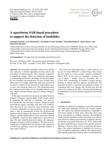
G. Esposito et al.: A spaceborne SAR-based procedure to support the detection of landslidesments and their average size with respect to the expected landcover changes. An example of the procedure for the selectionof the best values for the th and hr parameters is described inSect. 3.2.4Identification of areas potentially affected by landcover changesAfter the segmentation step, a statistical analysis of theLR pixel values included in each segment is carried out toidentify segments that are related to significant land coverchanges with high probability.For each segment, the arithmetic mean (µs ) of the includedLR pixel values is calculated as follows:!k1 Xpj ,(3)µs k j 1where s indicates the segment, p the pixel value and k thenumber of pixels in the segment. We define the “averagelayer” as the raster layer where each segment is associatedwith the corresponding value of µs . Afterwards, in order tofilter segments and extract only those representing significant statistical changes, the µs values have to be comparedwith reference µ and average standard deviation (σ ) relatedto no-change conditions. These reference figures have to becalculated before the initialization of the processing chainand after the segmentation of the event-related LR image,using preceding SAR images when no heavy rainfall, landslides and earthquakes occurred, by applying the followingformulas:!m1 Xµ pj ,(4)m j 1vu !2 Xuku1σs tpj µ s ,(5)k 1j 1!r1 Xσ σs ,(6)r z 1 zwhere m is the total number of pixels in the pre-event LR image used as reference, p is the related pixel value, and r is thetotal number of segments derived from the segmentation ofthe event-related LR image, characterized each one by a σs .In this way, both the µ and σ are calculated in a kind of“warm-up stage” of the described processing chain. Generally, these figures can be considered suitable if calculatedfrom three or four reference LR layers characterized by normally distributed values (i.e., Gaussian). Such a distributionin fact indicates the random nature of the LR values, whichis typical when land cover changes are not relevant. We highlight that in such a case, given that LR values are commonlysmall and positive or negative, the µ value is equal or veryclose to 3In this way, all the segments of the average layer characterized by µs values larger than µ (2σ ) are then extracted andclassified. Segments with µs values lower than a confidenceinterval of 95 % (µs µ (2σ ) ) are instead discarded. Segments where µs is greater than µ (2σ ) and smaller than µ (3σ ) are reclassified to the integer value of 2. Similarly,the values 3 and 4 are used to classify segments with µs values included in the range µ (3σ ) to µ (4σ ) and largerthan µ (4σ ) , respectively. All these segments form a newraster layer representing a map of areas characterized by relevant SAR amplitude changes, including those affected byrapid slope movements.In order to refine this map, all the segments with the samevalues (i.e., 2, 3, or 4), that are spatially contiguous and areformed by at least a user-defined minimum arbitrary size interms of pixels (i.e., minimum detectable landslide area) aremerged together, and the following statistics are then computed: (1) count of merged segments, (2) maximum numberof pixels included within a single segment and (3) averagenumber of pixels included within a single segment.The final segment map produced by the processing chain isgeoreferenced in the WGS84 reference system (EPSG 4326)by means of the terrain correction tool of SNAP.2.5Automatic implementation of the processing chainThe processes described before have been implemented intwo groups of scripts that can be executed automatically (inchain), according to the flowchart shown in Fig. 1. Theyare run after a preliminary one-time calibration phase, operated manually by the user and consisting of (1) the tuning of the i.segment parameters, carried out with the expertbased segmentation of an event-related LR image (Sect. 2.3),and (2) the computation of reference µ and σ related to nochange conditions, as described in Sect. 2.4.The python-based script (Fig. 1, Data ingestion) is devotedto the automatic querying and downloading of Sentinel-1SAR images from the ESA Sentinel Data Hub. The script,based on the SentinelSat toolbox (Kersten et al., 2018), is setto query the Sentinel Data Hub with a daily frequency, eventhough new images may be available every 6 or 12 d depending on the geographic area.The consecutive group of scripts written in GNU/Bashprogramming language (Fig. 1) is aimed at (i) preprocessingthe Sentinel-1 images (Sect. 2.1), (ii) detecting the changesin SAR amplitude and production of LR maps (Sect. 2.2),(iii) segmenting the LR maps (Sect. 2.3), and (iv) identifyingareas potentially affected by land cover changes (Sect. 2.4).This group of scripts is executed automatically when newSentinel-1 images are available and downloaded by thePython-based script.The Bash scripts require the following settings to be defined by the user: (1) the path of the folder where the downloaded SAR images are stored, (2) values of the parametersto use for the segmentation (see Sect. 2.3) and (3) the spaNat. Hazards Earth Syst. Sci., 20, 2379–2395, 2020
2384G. Esposito et al.: A spaceborne SAR-based procedure to support the detection of landslidesFigure 1. Flowchart representing the automatic steps of the processing chain implemented in two groups of scripts (developed using Pythonand Bash scripting languages). I (t1 ) and I (t2 ) represent two consecutive SAR images (or set of images).tial coordinates of the area of interest (if it is a portion of thedownloaded SAR images). No further information is neededsince the commands are executed in a unique automatic sequence. To survey the same area for an unlimited time period,all of these settings only have to be defined one time for thechain initialization.3The Papua New Guinea test siteWe selected an area located in central Papua New Guinea(Fig. 2) that was affected by a severe seismic sequence at thebeginning of 2018 as a test site. On 25 February, the area washit by a main seismic event (M7.5 ) followed by several aftershocks, including a M6.7 earthquake on 6 March. The strongmainshock, which was rather superficial with a hypocentraldepth at 25.2 km (USGS, 2018), caused buildings to collapse,road damage and widespread landslides, mostly along theTagari river valley and the slopes of Mount Sisa (McCue etal., 2018). According to the International Federation of RedNat. Hazards Earth Syst. Sci., 20, 2379–2395, 2020Cross and Red Crescent Societies (IFRC, 2018), more than100 people died, most of them due to landslides.To test the implemented procedure, we analyzed an area ofabout 3000 km2 in the mountainous region close to the epicenter of the mainshock (AoI in Fig. 2), where preliminaryinformation on landslides were available (Petley, 2018a, b).To simulate a periodic survey covering pre- and postearthquake periods, we downloaded 36 Sentinel-1 imagesfrom the Sentinel Data Hub (https://scihub.copernicus.eu/,last access: 24 January 2020) acquired along the satellite track no. 82 with a temporal frequency of 12 d, from12 November 2017 to 6 June 2018. Considering that the majority of the slopes in the study area are exposed towards thewest, to limit geometrical distortions in the single images andin the change detection estimation, we preferred to use IWSLC products acquired in ascending mode, wit
a one-time calibration of some parameters, the processing chain is able to automatically execute the download and preprocessing of images, the detection of SAR amplitude changes, and the identification of areas potentially affected by landslides, which are then displayed in a georeference