Transcription
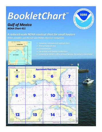
BookletChart Gulf of MexicoNOAA Chart 411A reduced-scale NOAA nautical chart for small boatersWhen possible, use the full-size NOAA chart for navigation.
Published by theNational Oceanic and Atmospheric AdministrationNational Ocean ServiceOffice of Coast Surveywww.NauticalCharts.NOAA.gov888-990-NOAAWhat are Nautical Charts?Nautical charts are a fundamental tool of marine navigation. They showwater depths, obstructions, buoys, other aids to navigation, and muchmore. The information is shown in a way that promotes safe andefficient navigation. Chart carriage is mandatory on the commercialships that carry America’s commerce. They are also used on every Navyand Coast Guard ship, fishing and passenger vessels, and are widelycarried by recreational boaters.What is a BookletChart ?This BookletChart is made to help recreational boaters locatethemselves on the water. It has been reduced in scale for convenience,but otherwise contains all the information of the full-scale nauticalchart. The bar scales have also been reduced, and are accurate whenused to measure distances in this BookletChart. See the Note at thebottom of page 5 for the reduction in scale applied to this chart.Whenever possible, use the official, full scale NOAA nautical chart fornavigation. Nautical chart sales agents are listed on the Internet athttp://www.NauticalCharts.NOAA.gov.This BookletChart does NOT fulfill chart carriage requirements forregulated commercial vessels under Titles 33 and 44 of the Code ofFederal Regulations.Notice to Mariners Correction StatusThis BookletChart has been updated for chart corrections published inthe U.S. Coast Guard Local Notice to Mariners, the National GeospatialIntelligence Agency Weekly Notice to Mariners, and, where applicable,the Canadian Coast Guard Notice to Mariners. Additional chartcorrections have been made by NOAA in advance of their publication ina Notice to Mariners. The last Notices to Mariners applied to this chartare listed in the Note at the bottom of page 7. Coast Pilot excerpts arenot being corrected.For latest Coast Pilot excerpt visit the Office of Coast Survey website t w.php?book 5[Coast Pilot 5, Chapter 3 excerpts]The Gulf of Mexico coast of the UnitedStates, from Key West, Fla., to the RioGrande, is low and mostly sandy,presenting no marked natural features tothe mariner approaching from seaward;shoal water generally extends welloffshore. The principal points and harborentrances are marked by lights, which arethe chief guides for approaching orstanding along the coast.From the S shore of the Florida mainland,the Florida Reefs extend for about 134 miles in the SW curve to SandKey Light, and about 58 miles in a W direction to Loggerhead Key. Thesekeys and reefs are of sand, shell, and coral formation. The reefs havefrequent shoal patches. The keys are generally low and covered withmangrove. Together, they form the N boundary of the Straits of Florida.Toward the W end are several openings between the keys offeringpassage from the straits into the Gulf.The SW extremity of the Florida mainland is part of the EvergladesNational Park and Big Cypress Swamp. Much of these areas are underwater throughout the year and are nearly all covered during the rainysummer season. Fronting the swampy areas are the Ten ThousandIslands, a group of low mangrove-covered islands divided by tidalchannels. N of the Ten Thousand Islands the coast is low, sandy, andgenerally backed by pine forests and Hammocks. These hammocks are ajungle of tropical trees, mostly hardwood, which appear as animpenetrable green wall.From Cape Romano to Anclote Keys the coast becomes a barrier beachof low islands separated by inlets, most of which are small and cannotbe distinguished from offshore. Between Anclote Keys and St. JamesIsland, the W side of Apalachee Bay, the coast is low and marshy for 1 to2 miles inland then backed by pine forests. The shoreline is broken by anumber of unimportant rivers and creeks.W of St. James Island to the South Pass of the Mississippi River, thecoast is mostly a barrier beach of low, wooded, sand islands. The generaldrift of these islands is to the W which causes an encroachment uponthe channels between them. Hurricanes and heavy gales will sometimeschange the shape of these islands and in some cases they have washedaway leaving only shoals.State Boundaries.–The boundary between Florida and Alabama followsthe Perdido River. The Alabama-Mississippi boundary follows a markedline cutting across the E end of Petit Bois Island, through Grande BattureIslands. Pearl River, from its most E junction with Lake Borgne, forms theboundary between Mississippi and Louisiana.St. Petersburg, a large winter resort city, is on the W side of Tampa Bay6 miles S of Gandy Bridge; and major highways connect it with all partsof the State. The Gandy Bridge and Frankland Bridge offer a short routeto Tampa, and the Sunshine Skyway, a toll bridge, connects with pointsto the S.St. Petersburg has a city hospital and several private hospitals. Gasoline,diesel fuel, water, ice, provisions, and marine supplies are available inquantity. Boats can be chartered and guides engaged. The St.Petersburg–Clearwater International Airport is N of the city, and theAlbert Whitted Municipal Airport is on the E waterfront at the center ofthe city.Point Pinellas channel extends N for about 5.5 miles from deep water inlower Tampa Bay to an entrance channel leading W to basins at the Portof St. Petersburg and Bayboro Harbor. In 2008, the controlling depthswere 19 feet in Point Pinellas channel, thence 21 feet in the entrancechannel to the turning basin at the Port of St. Petersburg with depths of21 to 23 feet in the basin, except for shoaling in the SE corner near Light10, thence 15 feet to the basin at Bayboro Harbor with 10 to 12 feetavailable in the basin, except for lesser depths along the S edge.U.S. Coast Guard Rescue Coordination Center24 hour Regional Contact for EmergenciesRCC New Orleans2Commanderth8 CG DistrictNew Orleans, LA(504) 589-6225
Lateral System As Seen Entering From Seawardon navigable waters except Western RiversPORT SIDEODD NUMBERED AIDSGREEN LIGHT ONLYFLASHING (2)FLASHINGOCCULTINGQUICK FLASHINGISOPREFERRED CHANNELNO NUMBERS – MAY BE LETTEREDPREFERRED CHANNELNO NUMBERS – MAY BE LETTEREDPREFERRED CHANNEL TOSTARBOARDTOPMOST BAND GREENPREFERRED CHANNELTO PORTTOPMOST BAND REDGREEN LIGHT ONLYRED LIGHT ONLYFLASHING (2)FLASHINGOCCULTINGQUICK FLASHINGISORED LIGHT ONLYCOMPOSITE GROUP FLASHING (2 1)COMPOSITE GROUP FLASHING (2 1)812"1"Fl G 6sLIGHTGR "A"Fl (2 1) G 6sG "9"Fl G 4s5DAYBEACON"2"Fl R 6sRG "B"Fl (2 1) R 6sG"5"UCGR"U"RGN "C"GRC "S"CANG6RG"G"NUNFor more information on aids to navigation, including those on Western Rivers, please consult the latest USCG Light List for your area.These volumes are available online at http://www.navcen.uscg.govRN "6"NUNR "8"Fl R 4sLIGHTED BUOYLIGHTLIGHTED BUOYGC "1"CANSTARBOARD SIDEEVEN NUMBERED AIDS2DAYBEACONR"2"
VHF Marine Radio channels for use on thewaterways:Channel 6 – Inter-ship safety communications.Channel 9 – Communications between boats andship-to-coast.Channel 13 – Navigation purposes at bridges, locks, andharbors.EMERGENCY INFORMATIONChannel 16 – Emergency, distress and safety calls toCoast Guard and others, and to initiate calls to othervessels. Contact the other vessel, agree to another channel, and then switch.Channel 22A – Calls between the Coast Guard and the public. Severe weatherwarnings, hazards to navigation and safety warnings are broadcast here.Channels 68, 69, 71, 72 and 78A – Recreational boat channels.Distress Call Procedures Make sure radio is on. Select Channel 16. Press/Hold the transmit button. Clearly say: “MAYDAY, MAYDAY, MAYDAY.” Also give: Vessel Name and/or Description;Position and/or Location; Nature ofEmergency; Number of People on Board. Release transmit button. Wait for 10 seconds — If no responseRepeat MAYDAY call.Getting and Giving Help — Signal other boaters using visual distress signals (flares,orange flag, lights, arm signals); whistles; horns; and on your VHF radio. You arerequired by law to help boaters in trouble. Respond to distress signals, but do notendanger yourself.HAVE ALL PERSONS PUT ON LIFE JACKETS!NOAA Weather Radio All Hazards (NWR) is a nationwide network of radio stations broadcasting continuousweather information directly from the nearest National Weather Service office. NWR broadcasts official WeatherService warnings, watches, forecasts and other hazard information 24 hours a day, 7 days a week.http://www.nws.noaa.gov/nwr/Quick ReferencesNautical chart related products and information - http://www.nauticalcharts.noaa.govQRInteractive chart catalog - .shtmlReport a chart discrepancy - hart and chart related inquiries and comments - page ContactUsChart updates (LNM and NM corrections) - http://www.nauticalcharts.noaa.gov/mcd/updates/LNM NM.htmlCoast Pilot online - htmTides and Currents - http://tidesandcurrents.noaa.govMarine Forecasts - http://www.nws.noaa.gov/om/marine/home.htmNational Data Buoy Center - http://www.ndbc.noaa.gov/NowCoast web portal for coastal conditions - http://www.nowcoast.noaa.gov/National Weather Service - http://www.weather.gov/National Hurrican Center - http://www.nhc.noaa.gov/Pacific Tsunami Warning Center - http://ptwc.weather.gov/Contact Us - tmFor the latest news from Coast Survey, follow @NOAAchartsThis Booklet chart has been designed for duplex printing (printed on front and back of one sheet). If a duplex optionis not available on your printer, you may print each sheet and arrange them back-to-back to allow for the properlayout when viewing.NOAA’s Office of Coast SurveyThe Nation’s Chartmaker
St. Petersburg has a city hospital and several private hospitals. Gasoline, diesel fuel, water, ice, provisions, and marine supplies are available in quantity. Boats can be chartered and guides engaged. The St. Petersburg C