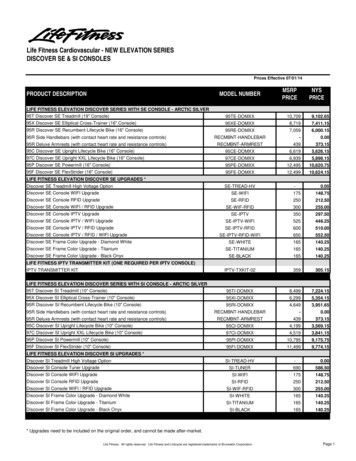
Transcription
Digital Elevation ModelTechnologies and Applications:The DEM Users Manual,3rd EditionDavid F. Maune, PhD, CP andAmar Nayegandhi, CP, CMS1 Coastal GeoTools Conference February 8, 2017
1st edition (2001) & 2nd edition (2007)2 Coastal GeoTools Conference February 8, 2017
DEM status in 2007 (2nd edition) We had no DEM standardproducts other than the lowerresolution National ElevationDataset (NED) We had no national Lidarstandards or specificationsother than the FEMAGuidelines (2’ & 4’ contouraccuracy) for the NFIP The 2nd edition’s UserRequirements Menu andsample SOWs helped usersdevelop their own nonstandard DEM products3 Coastal GeoTools Conference February 8, 2017
Progress during the past decade 2010: USGS’ draft Lidar Guidelines and Base Specifications, V.13 2011: National Enhanced Elevation Assessment (NEEA) 2012: USGS’ Lidar Base Specification, V1.0 2013: USGS’ 3D Elevation Program (3DEP) (QL2 Lidar & QL5 IfSAR) 2013: ASPRS’ LAS Specification, V1.4, and 2014: ASPRS Positional Accuracy Standards for Digital Geospatial Data 2014: USGS’ Lidar Base Specification, V1.2 2015: USACE’s EM 1110-1-1000, Photogrammetric and Lidar Mapping 2016: FEMA’s Elevation Guidance for Flood Risk Analysis & Mapping 2017: NEEA Update and Coastal/Offshore Elevation Requirements andBenefits Study -- vision for a “3D Nation” from the tops of the mountainsto the depths of the sea.4 Coastal GeoTools Conference February 8, 2017
3rd HydroEdition,tobepublishedin2017fromIFSARMerger ofsonar w/ topo& bathy LidarTopobathyLidarThe 3rd edition supports ourvision of a future seamless,consistent, high-accuracy,high-resolution 3D Nation,from the tops of the mountainsto the depths of the sea, thatis cost-effective and up-todate. This includessubmerged topography.Every chapter supports thisvision – even the front cover5 Coastal GeoTools Conference February 8, 2017
3rd Edition, to be published in 20171.2.3.4.5.6.7.8.9.10.11.12.13.14.15.16.6 Coastal GeoTools Conference February 8, 2017Introduction to DEMsVertical DatumsStandards, Guidelines & SpecificationsThe National Elevation DatasetThe 3D Elevation ProgramPhotogrammetryIfSARAirborne Topographic LidarLidar Data ProcessingAirborne Lidar BathymetrySonarEnabling TechnologiesDEM User ApplicationsDEM User Requirements and BenefitsQuality Assessment of Elevation DataSample Elevation Datasets
Ch. 1: Introduction to DEMs(Dave Maune, Karl Heidemann, Stephen Kopp, Clayton Crawford)Definitions and terminologyHydrologic surface modeling:Raster, vector, point cloud data Hydro-flatteningDEMs, DTMs, DSMs Hydro-enforcementMass points and breaklines (2D,2.5D and 3D) Hydro-conditioningTINs, Terrains, LAS datasetsContours3D surface modelingTerrain visualization, virtual realityElevation derivatives (hillshades,slope, aspect and curvature maps,profiles, cross-sections)Different types of mapsDifferent interpolation methods forcreating DEMs from TINsImproved Appendix A (Acronyms), Appendix B (Definitions), and Index7 Coastal GeoTools Conference February 8, 2017
Hydro-flattened vs. hydro-enforced8 Coastal GeoTools Conference February 8, 2017
Ch. 2: Vertical Datums (Dru Smith)Reference Surfaces (where iszero height or elevation?)Sea level and ocean tidesTidal datums (MHHW, MLHW,MHW, MSL, MLW, MHLW, MLLW)The Geoid (elevations follow therules of gravity)The Ellipsoid (GPS coordinatesfollow the rules of geometry)Heights: Orthometric heights Ellipsoid heights Dynamic heights9 Coastal GeoTools Conference February 8, 2017Vertical datums (NAVD88,NGVD29, PRVD02, ASVD02,NMVD03, GUVD04, VIVD09,IGLD85)Horizontal datums (NAD83,WGS84)Converting heights/vertical datumsGeoid undulationsTransformation toolsFuture vertical datums resultingfrom NGS’ GRAV-D and datumadjustments (in 2022, all x/y and zcoordinates will change)
Orthometric heights are what mostpeople call “elevations”10 Coastal GeoTools Conference February 8, 2017
Ch. 3: Standards, Guidelines andSpecifications (Dave Maune)FGDC Standards, including: National Standard for SpatialData Accuracy (NSSDA) Standards for Nautical ChartingHydrographic SurveysASPRS Standards & Specs: Positional Accuracy Standardsfor Digital Geospatial Data(defines new vertical accuracyclasses w/ NVA and VVA) LAS Specification, V1.411 Coastal GeoTools Conference February 8, 2017USGS Lidar Base SpecificationV1.2NOS Hydrographic SurveysSpecifications and DeliverablesNDEP Guidelines for DigitalElevation Data (defines old verticalaccuracies: FVA, CVA and SVA)USACE EM 1110-1-1000,Photogrammetric & Lidar MappingGeodetic Control Standards andGuidelines
USGS Lidar Base Specification, v1.2QL2 lidar or better -- acceptable for the 3DEPQL3 lidar or worse -- not acceptable for the 3DEP, except for QL5 IfSAR in Alaska12 Coastal GeoTools Conference February 8, 2017
IHO standards for depth uncertaintyat the 95% confidence levelThese IHO standards willprobably be used by NGSto establish bathymetriclidar equivalents to USGS’topographic lidar QualityLevels (QL0, QL1, QL2and QL3) with:QL0B (IHO Special Order)QL1B (IHO Special Order)QL2BQL3BQL4B (IHO Order 1a)13 Coastal GeoTools Conference February 8, 2017
Ch. 4: The National Elevation Dataset(Dean Gesch, Gayla Evans, Michael Oimoen, Samantha Arundel)Background, rationale, historySpecifications and productionSource dataProduction processingSpatially referenced metadataAccuracy and data quality Absolute vertical accuracy Relative vertical accuracyComparison with other large-areaelevation datasetsApplications14 Coastal GeoTools Conference February 8, 2017The National Elevation Datasetand acronym (NED) were retiredwhen the 3D Elevation Program(3DEP) became operationalCurrent developments and futuredirectionsUSGS is developing a new line ofscience products known as theCoastal National ElevationDatabase (CoNED) whichintegrates recent high resolutioncoastal lidar data (both topo andbathy) and a temporal componentfrom captures on different dates
Coastal National Elevation Database(CoNED)15 Coastal GeoTools Conference February 8, 2017
Ch. 5: The 3D Elevation Program (3DEP)(Jason Stoker, Vicki Lucas, Allyson Jason, Diane Eldridge, LarrySugarbaker)Background, rationale, historyUSGS commitment to managenational elevation data assetsAssessment of requirements andBenefit/Cost Analysis (NEEA)Broad Agency Announcement(BAA) processAcquisition trends3DEP data quality assurance3DEP development, based onQL2 lidar, 8-year cycle, QL5IfSAR for Alaska3DEP products and servicesData acquisition proceduresCurrent development and futuredirections:U.S. Interagency ElevationInventory (USGS and NOAA)USGS Lidar Base Specification16 Coastal GeoTools Conference February 8, 20173DEP data dissemination Geiger-mode lidar Single-photon lidar
Typical lidar point cloud beingcollected for the 3DEP17 Coastal GeoTools Conference February 8, 2017
Ch. 6: Photogrammetry (J. Chris McGlone)Sensor types:Post-processing & quality control Airborne digital systemsData deliverables Satellite imageryEnabling technologiesProject planning considerationsCalibration proceduresGeoreferencing & aerotriangulationCapabilities and limitationsPhotogrammetric data collectionmethods:Comparisons with competing /complementary technologies Softcopy stereoplottersDEM user applications Manual elevation compilationCost considerations Automated elevation collectionTechnological advancements Semi-global matching (SGM) Structure from motion (SfM)18 Coastal GeoTools Conference February 8, 2017
True-ortho vs. standard ortho19 Coastal GeoTools Conference February 8, 2017
Ch. 7: IfSAR(Scott Hensley, Lorraine Tighe) Technology Overview Developmental History IfSAR MappingTechniques IfSAR Present OperatingStatus Airborne IfSAR Systems Spaceborne IfSAR Systems IfSAR Data PostProcessing Comparison with OtherTechnologies IfSAR Quality Control User Applications IfSAR Data Deliverables Mapping Alaska –America’s Last Frontier Cost Considerations20 Coastal GeoTools Conference February 8, 2017 Technology Advancements
IfSAR DTM of Alaska hydro features21 Coastal GeoTools Conference February 8, 2017
Ch. 8: Airborne Topographic Lidar(Amar Nayegandhi) Introduction Basic Concepts Light and the ElectromagneticSpectrum Attenuation and Reflectance Laser Ranging Transmit Laser pulse characteristics Laser Scanning techniques Discrete return vs. Waveformresolving Lidar Detection Methodology Linear vs. Photon-based lidar 3-D Flash Lidar Technology Geiger Mode Lidar22 Coastal GeoTools Conference February 8, 2017Developmental HistoryAirborne Lidar OperationsData ProcessingCurrent Sensor TechnologyComparison withOverlapping Technologies User Applications
Ch. 8: Airborne Topographic Lidar23 Coastal GeoTools Conference February 8, 2017
Ch. 9: Lidar Data Processing (Josh Novac) Introduction Lidar Processing Concepts and Approaches Automated Filtering Filtering Ground/Non-Ground points Noise Structures Vegetation Other above ground features Manual Editing Breakline Processing Concepts and Approaches Automated Processing Options Water Structures Other24 Coastal GeoTools Conference February 8, 2017 Manual ProcessingOptions Lidargrammetry Elevation Conflation DEM Processing Concepts andApproaches Processing Techniques Terrain Point Cloud Other Incorporating Breaklines Hydro-Flattening Hydro-Conditioning Hydro-Enforcement DSM Processing
Ch. 9 Lidar Data ProcessingLidar ProcessingTwo examples of Lidar classification. The top picture represents ahigher level of classification including vegetation and buildings.The bottom example shows ground/non-ground and waterclassified.25 Coastal GeoTools Conference, February 8, 2017Breakline ProcessingTwo examples of breakline extraction. The topimage represents detailed breaklines extractedusing automated methods in eCognition. Thebottom represents ponds collected through acombination of automated and manual methods.
Ch. 9: Lidar Data ProcessingDEM Processing26 Coastal GeoTools Conference February 8, 2017
Ch. 10: Airborne Lidar Bathymetry(Jennifer Wozencraft and Amar Nayegandhi) Introduction Bathymetric vs Topobathymetric Lidar Basic Concepts Refraction at air/water interfaceState of the sea surfaceBubbles and breaking wavesOptical properties of the watercolumn Beam attenuation coefficient, DiffuseAttenuation Coefficient (Kd) and theSecchi Depth Characteristics of the sea floor Basic System Design Laser Transmitter UnitScanner UnitReceiver UnitEnabling Technologies27 Coastal GeoTools Conference February 8, 2017 Developmental History Data Processing Expectations from ALBSystems ALB Eye Safety Features Depth Penetration &Accuracy Current Sensor Technology Comparison with OverlappingTechnologies User Applications
Ch. 10: Airborne Lidar BathymetryAMPLITUDEVolumeBackscatter rnTIME28 Coastal GeoTools Conference February 8, 2017
Ch. 11: Sonar (Guy Noll)Technology overviewPresent operating status:Developmental historyPlatforms and installationBasic principles of acousticmapping:Calibration procedures Acoustic sources Directional transmit/receivetransducersTypes of sonars: Vertical beam sonar Multibeam sonar Side scan sonar Interferometric/focusing/Doppler29 Coastal GeoTools Conference February 8, 2017Planning considerationsCapabilities and limitationsComparisons with complementaryand competing technologiesPost processingQuality controlData deliverablesCost considerationsTechnology advancements
Individual beams in a multibeamtransducer form a swath30 Coastal GeoTools Conference February 8, 2017
Ch. 12: Enabling Technologies(Bruno Scherzinger, Joe Hutton, Mohamed Mostafa)GNSS positioning technologies: GNSS single point positioning Differential GNSS Precise phase interferometrypositioningGNSS-aided Inertial Navigationtechnologies (GNSS-AINS): Inertial navigation systems (INS) GNSS-AINS for directgeoreferencing Precise point positioning (PPP)Direct georeferencing systems forairborne DEM generationLocal, regional and globaldifferential GNSS Types of airborne DG systemsContinuously Operating ReferenceStations (CORS)Types of sensorsError sources Boresight calibration Post processingMotion sensing system formultibeam sonar bathymetry Types of sensors31 Coastal GeoTools Conference February 8, 2017
IMU-GNSS and Camera-GNSS leverarm calibration32 Coastal GeoTools Conference February 8, 2017
Ch. 13: DEM User Applications(Dave Maune)NEEA’s 27 Business UsesGeneral mapping applications(digital orthophotos, topographicmaps, flood maps)Special mapping applications(soils, geologic, wetland, forestry,wildlife habitat, cultural resources,urban and regional planning maps)Coastal mapping applications(Digital Coast, SLR viewing,shoreline delineation, coastalmanagement and engineering,coastal flood hazard mapping)Underwater applications33 Coastal GeoTools Conference February 8, 2017Transportation applications(land, aviation and marinenavigation and safety)Technical applications (nationalresources conservation, H&Hmodeling, water supply,stormwater, subsidence)Military applicationsCommercial applications(precision agriculture, mining,renewable energy, oil and gas,telecommunications, recreation)Individual applications (elevationcertificates, individual parceltopographic maps)
Includes graphic examples of 27Major Business Uses in the NEEAThese Business Uses did not include general mapping applications or individualapplications34 Coastal GeoTools Conference February 8, 2017
Ch. 14: DEM User Requirements andBenefits (Dave Maune)DEM User Requirements:Benefits of 3DEP Standard Prod:Need for all users to focus onstandardized QL2 lidar or better,standard 3DEP deliverables: Single authoritative source of highquality & consistent 3DEP data atlower costs to all Standard metadata Standard classified point cloud Standard 3DEP products that usecommon hardware/software,standard training for data usersand producers Standard hydro-flattened, bareearth raster DEM Easier generation of derivativeproducts from standard source Standard breaklines 5:1 Return on Investment Standard raw point cloud Common data upgrades that donot compromise standardizationand interoperability35 Coastal GeoTools Conference February 8, 2017 Planned data updates Seamless data from tops ofmountains to depths of the sea
Highest ROI from QL2 Lidarwith 6-10 year update cycleB/C Ratio 5:1computed usingconservativebenefits ( 1.3B/yr)B/C Ratio 50:1 ifcomputed usingpotential benefits( 13.3B/yr)Actual B/C Ratio isincreasing as Lidarcosts aredecreasingsubstantially36 Coastal GeoTools Conference February 8, 2017
Ch. 15: Quality Assessment(Jen Novac,100-page tutorial approved by Karl Heidemann, incl. 96 images)Standards, Guidelines and Specs Macro level review of DEM dataQuantitative Assessments: Micro level review of DEM data: Accuracy assessments (relativeand absolute vertical accuracy) Absolute horizontal accuracyassessments Accuracy reporting DEM visualization and display DEM raster types (DSMs, bareearth DTMs, bathymetric andtopobathymetric DEMs) Qualitative reviews Artifacts/over-smoothingQualitative Assessments: Source data QA/QC Breakline QA/QC Breakline completeness Breakline variance Breakline topology37 Coastal GeoTools Conference February 8, 2017 Inconsistent editing Hydro-flattening or enforcement Edge-matching QA/QC of contours QA/QC of metadata
Boresight / Calibration38 Coastal GeoTools Conference February 8, 2017
ΔZ Ortho Relative Accuracy Eval.39 Coastal GeoTools Conference February 8, 2017
“Floating” hydro breakline vertices(just one of dozens of hydro issues explained)40 Coastal GeoTools Conference February 8, 2017
Bridge Removal Interpolation Artifact(aka “Bridge Saddle”)Lidar projects processed to USGS specifications must have “bridge saddles”corrected and removed in the final bare earth DEMs to create a continuoussurface beneath the bridge.41 Coastal GeoTools Conference February 8, 2017
Building Removal Interpolation42 Coastal GeoTools Conference February 8, 2017
Hardcopy and eBookASPRS is no longer printinghardcopy books or maintaining awarehouse of books for sale.Dewberry is paying for the layoutand printing of limited hardcopies,500 copies of which will be sold byASPRS and mailed by Dewberry.ASPRS will arrange for low-costeBooks to be sold and distributed(by Amazon or others) directly tostudents and other users.We hope to have both versionsavailable for sale by June, 2017.43 Coastal GeoTools Conference February 8, 2017
(Digital Coast, SLR viewing, shoreline delineation, coastal management and engineering, coastal flood hazard mapping) Underwater applications Ch. 13: DEM User Applications (Dave Maune) Transportation applications (land, aviation and marine navigation and safety) Technical applications (nationa