Transcription
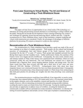
From Laser Scanning to Virtual Reality: The Art and Science ofConstructing a Thule Whalebone House11Richard Levy and Peter Dawson2Faculty of Environmental Design, University of Calgary, 2500 University Dr. NW, Alberta, Canada, T2N 1N4rmlevy@ucalgary,ca2Department of Archaeology, 2500 University Dr. NW, Alberta, Canada, T2N 1N4pcdawson@ucalgary.caAbstractThis paper will also focus on opportunities to use virtual reality (VR) technology as alaboratory for testing and presenting research alternatives in archaeology to college students andthe public. During the last decade the development of laser scanning technology has created anew technique for capturing, preserving and analyzing objects, artifacts and sites. Using thereconstruction of a Thule whalebone house, issues of data translation, computer modeling andvirtual world construction are considered. Finally, the advantages of advantages of differentplatforms for presenting 3D content as interactive worlds are also explored.Reconstruction of a Thule Whalebone HouseThe reconstruction of a Thule whalebone house provides a good case study of the use oflaser scanning on an object of complex geometry. Thule peoples are the cultural and biologicalancestors of contemporary Inuit and Eskimo groups of the North American Arctic andGreenland. By the late 12th or early 13th century, Thule groups had expanded eastward from theBering Strait region into the Canadian Arctic. Unlike northwestern Alaska, the coastlines of theEastern Arctic were largely devoid of driftwood. Consequently, the main rooms, kitchen areas,and entrance tunnels of Thule winter houses were constructed from whalebone, which was usedextensively within the roof framework. This roof framework was erected over a house pitfurnished with a flagstone floor, raised sleeping platform, kitchen, and storage areas. The roofframe would have then been covered with hide and a thick layer of turf, moss and snow(Maxwell 1985:248; McGhee 1978:92,95). Archaeologists know little about how theseenigmatic houses were constructed because few have ever been encountered intact. Consequentlythe possibility of reconstructing a three dimensional model of a Thule house from archaeologicaldata held great promise for providing new insights into how these dwellings were constructedand used.The reconstruction process would have been difficult, if not impossible, to resolve using2D drawings since manual drafting or 2D CAD cannot easily solve a 3D structural system basedon the organic elements, such as the mandibles, cranium and maxillas of a whale. Physicalmodels, however, offer an interesting environment for manually testing possible solutions,avoiding the need to create curvilinear forms from 2D drawings. Tracing the modeling processalso provides an opportunity to address issues of workflow, revealing the limitations ofcommercially available software and hardware in data translation. Furthermore, we illustrate thetesting of research hypotheses and include a review of the types of products created during the1
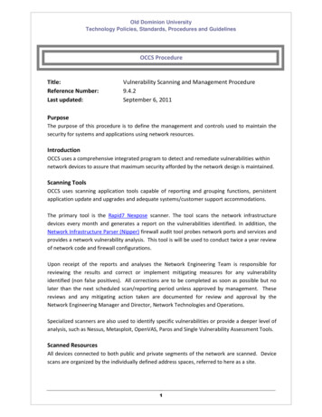
process of reconstruction to serve the needs of researchers, teachers and museum curators, aswell as the different platforms for disseminating visual content.Scanning a whale: From real to virtualBeginning in 2003, we began exploring a strategy for creating 3D computerreconstructions of Thule whalebone houses based on these earlier field studies. Ultimately, it washoped that by working in a 3D environment, the potential arrangements of elements found atarchaeological sites could be tested for their structural stability. Many of the elements of thesestructural forms are made from Bowhead whalebone. A major impediment in this project waslocating a 3D computer model of a bowhead whale: an accurate model could only bereconstructed if geometry of the major structural elements (mandibles, cranium, maxillas andribs) could be obtained.The first approach was to consider the translation of 2D drawings of whale skeletons into3D models, but the complexity of these organic forms made translation of simple elevationstudies done by biological illustrators since the nineteenth century all but impossible. A secondapproach of finding a plastic model of a skeleton used for instruction and teaching provedfruitless. Fortunately, a mounted specimen of a North Atlantic Right Whale exists at the NewEngland Aquarium in Boston (Fig. 1). The North Atlantic Right Whale (Eubalaena glacialis) issmaller than the Bowhead whales (Balaena mysticetus) hunted by Thule groups, but both share asimilar skeletal morphology. Using a Cyrax2500, a commercially available laser scanner, anaccurate mesh with good accuracy (5mm) could be achieved (Johansson 2002).Fig. 1. North Atlantic Right Whale: Left - photo, Right – laser scan, New England Aquarium, Boston, MA.From points to meshConverting million of points into an optimized mesh required several steps and is acritical stage in the reconstruction process. Depending on the application used for modeling, theexact process can vary, though the issues encountered in this translation will be the same.Cyclone, an application that supports the Cyrax2500 during the acquisition of points in the fieldwas used to register the different scans into a single space. A point file (PTX format) was thenimported into Polyworks (Innovmetrics) to create the mesh files needed for modeling. CAD andmodeling programs like 3DStudio from AutoDesk require files that contain points tied togetherinto a continuous mesh (Fig. 2).2
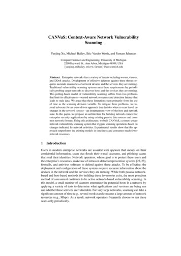
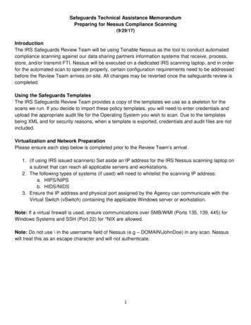
Fig. 2. Computer model of an arctic Thule whale bone house from Bathurst Island, NunavutModeling in virtual spaceThe modeling process relied on 3DStudioVIZ (AutoDesk), an application commonlyused in architecture, design and game and film-making for creating and rendering 3D objects andentire worlds. The reconstruction process was not unlike building the actual physical structure.The first step involved importing the 2D CAD file created from work conducted at the Deblicquysite located on Bathurst Island in 1994 by P. Dawson (Dawson 2001, Levy 2004).Prior to rendering images of the completed house form, lights representing the intensityof whale-oil lamps were added to the interior space. The renderings completed in 3DStudio cantake advantage of photometric-rendering algorithms that simulate light intensity and the level ofreflectivity of the surfaces. Unfortunately, an estimate for the illumination power of a whale oillamp can only result in an approximate lighting solution (Fig. 3). Future research with replicas ofwhalebone lamps will provide empirical data on their luminescent characteristics and shouldresult in more accurate rendering of the interior space.Testing for structural stabilityTo go beyond the level of visual inspection, mesh files representing the pit and boneswere imported into Virtools, a development application for creating virtual worlds. Oneimportant advantage of this approach is the ability to assign physical properties to each of thestructural elements. Using the Havoc physics engine (a module within Virtools), each of thewhalebones was assigned a mass, and a coefficient of friction was also given to the bone andstone surfaces. To simulate the lashing of the major elements at the apex of each room, a seriesof pivots or hinges were created, tying the structure together. In virtual space, the structure seeksequilibrium after the assignment of physical properties and will then either remain standing orcollapse under its own weight. Taking this approach gives the researcher an opportunity to refinethe reconstruction by obtaining information on the location of the structural elements after theyhave reached an equilibrium state. Though only a first step in a structural analysis of a complex3
form, adding a degree of physicality to the virtual objects can help archaeologists test the validityof reconstructions in an interactive world.Display and interactionVirtual-world authoring can have many benefits to the research team by creatinginteractive worlds distributed on the World Wide Web, or viewed in CAVE environments(Addison 2000). Currently, the researchers are testing a version of the Thule whalebone housefor teaching archaeology. Running the VRPACK module of Virtools (www.Virtools.com), thismodel can be viewed with shutter glasses on a CRT display or projected in a CAVEenvironment. This active stereo format is dependent on sequential frame buffering of left andright views. At a minimum frame rate of 60hz, the image will appear in stereo. In the CAVEenvironment, the 3D effect is created using four projectors supported by a cluster of fourcomputers. For students, having the opportunity to view the whalebone house in an immersiveenvironment provides a vehicle for understanding the complex geometry of these dwellings.Testing research hypotheses can be done in a highly graphical context using objects with virtualphysical properties, allowing students to understand basic principles of structures and to be ableto explore connections between space, light and culture. One issue of a CAVE environment isthat interaction is generally limited to a single user, making it more of a theatre for thoseobserving without trackers and other input devices. Though CAVEs are not common on mostcollege campus, the ability to construct one from standard workstations will greatly expand thefuture of this technology in research and education.ConclusionIn reconstructing the Thule whalebone house, laser scanning was essential in capturingthe geometric forms of the major skeletal features of a bowhead whale. Creating these modelsbegan with cloud data and ended with optimized meshes. In this project, having mesh models ofthe mandibles, maxillas and cranium from a bowhead whale, accurate to a centimetre or less,made it possible to create and test design alternatives in a modeling environment. By assigningphysical properties in a virtual model, it was possible to test the structural stability of theproposed model.The value of these models is their use in a virtual laboratory. Providing researchers withan interactive environment and opportunities to engage research alternatives can be a usefultechnique in arriving at the final model. However, once created, they can also serve to educatestudents and the public by providing an experiential environment for understanding howarcheological data can serve as the basis for the recreation of historic structures. At this stage inthe process, issues of display and interaction become important, with CAVEs and stereoscopicdisplay technology providing viewers with an immersive experience. Distributing these worldsfrom the World Wide Web, anyone with a personal computer built in the last few years has theopportunity to download and experience a virtual world in real time.ReferencesAddison, A.C. (2000) Emerging Trends in Virtual Heritage, IEEE Multimedia, April –June, 22-25.Dawson, P. 2001 Interpreting variability in Thule Inuit Architecture: A case study fromthe Canadian High Arctic. American Antiquity 664
Innovmetric (2004 ) www.Innovmetric.com Ste-Foy, QC, Canada.Johansson, M. (2002) Explorations into the Behavior of Three Different High-ResolutionGround-Based Laser Canners in the Built Environment, Proc. CIPA WG Int. Workshop onscanning for cultural heritage recording. http://www.isprs.org/commission5/workshop/Levy, M., P. Dawson and C. Arnold 2004 Reconstructing traditional Inuit house formsusing 3 dimensional interactive computer modeling. Visual Studies 1:26-35.Maxwell, M 1985 Prehistory of the Eastern Arctic. Academic Press, New York.McGhee, R 1978 Canadian Arctic Prehistory. Van Nostrand Reinhold, Toronto.Virtools, SA, www.Virtools.com, Paris, France.Fig3.Computer reconstruction,interior view Thule whalebone house from BathurstIsland, Nunavut5
1 From Laser Scanning to Virtual Reality: The Art and Science of Constructing a Thule Whalebone House Richard Levy 1 and Peter Dawson2 1Faculty of Environmental Design, University of Calgary, 2500 University Dr. NW, Alberta, Canada, T2N 1N4 rmlevy@ucalgary,ca 2Department of Archae