Transcription
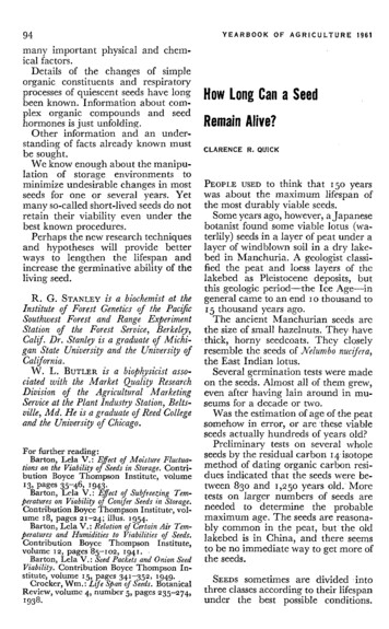
2 - FOREST HISTORY2.1 - Pre-European Settlement History (Glaciation to 1800’s)The present physical geography of the State of Michigan is a direct result of theWisconsinan glaciation of the Pleistocene Epoch, when the state was totally covered by ice.As the present inter-glacial period began and the ice sheet gradually receded, southernLower Michigan became mostly ice free approximately 13,000 years before present (B.P.).Upper Michigan became ice free approximately 10,000 B.P. The present landform and soilsof Michigan are the result of post-glacial lakes, rivers, erosion and soil developmentprocesses acting upon the glacial deposits, resulting in a diversity of terrain featuresincluding moraines, drumlins, eskers, kames, outwash plains and former lake beds that areinterspersed with numerous lakes, streams and depressions, including four of the world’slargest freshwater lakes.It was upon this landscape of raw post-glacial parent material that life gradually returned.The primary succession of plant life was heavily influenced by the nature of the parentmaterial, the climate (that was still very much influenced by the receding ice sheets) and theformation and disappearance of proglacial lakes. Theories of the succession of plant lifefrom barren soil to tundra, and the migration of forest tree species and some animal speciesfrom their glacial refugia are fairly well established (Davis 1981 and Pielou 1991). Postglacial succes sion and development of forest and animal communities were first driven by agradual warming of the climate, culminating in the hypsithermal of the current interglacialoccurring approximately 7,000 B.P., and then by the subsequent and present cooling trendtoward the next glaciation. The post-glacial landscape provided an abundance of habitat fora wide diversity of forest, savanna and aquatic plant and animal communities, which weredistinctly influenced by Native American cultures that inhabited the two peninsulas, mostnotably through hunting and fishing activities and their interaction with the fire regimes ofboth savanna grasslands and pine lands. A comprehensive description of the complexity ofthe post-glacial climatic and anthropogenic interaction with plant and animal communitiescan be found in Pielou 1991.The present landscape of Michigan is comprised of four distinct eco-regions (Figure 2.1):Southern Lower Michigan; Northern Lower Michigan; Eastern Upper Michigan; and WesternUpper Michigan. Each eco-region is distinct in its climate, physiography, soils andvegetation. These distinctions are a result of the peninsular configuration of the state, whichdramatically affects the climatic differences of both peninsulas. The distinctiveness of warm,vegetatively diverse Southern Lower Michigan and cold Upper Michigan is largely due totheir latitudinal positions and the continental land masses on their southern borders. Thefour Great Lakes that surround the state also provide a significant influence upon the climatein portions of both peninsulas (Albert 1995).The pre-European settlement (circa 1800) vegetative patterns for the State are based uponan interpretation of the Federal General Land Office (GLO) surveys of 1816-1856 (Figure2.2). Between 1816 and 1856 the State was surveyed by the Federal Government’sGeneral Land Office (GLO), with surveys of the Lower Peninsula beginning in 1816 andsurveys of the Upper Peninsula beginning in 1840. The interpretation of cover types onthese maps is interpolated from section line and corner witness trees, similar landform,surface geology and soils data. Inclusions of dissimilar cover types that do not intersect asection line may not be reflected upon the maps. Despite these qualifications, the GLOsurvey maps provide a consistent landscape level perspective of the circa 1800 cover types19
Figure 2.1. Regional Landscapes Ecosystems of Michigan.(Adapted from Albert, 1995)Figure 2.2. Vegetation of Michigan circa 1800.(Michigan Natural Features Inventory, 1998)20
Figure 2.2 (Continued). Vegetation of Michigan circa 1800.(Michigan Natural Features Inventory, 1998)21
of the entire state. The maps are useful for assessing broad post-settlement trends fordifferent cover types, the type and scale of pre-settlement disturbance regimes, and forconsideration in the restoration of selected cover types.The forest and other landscape communities that existed circa 1800 consisted of a mosaicof vegetative patterns ranging from remnant hypsithermal savanna grasslands and southernhardwood forests in Southern Lower Michigan, to northern hardwood and pine forests inNorthern Lower Michigan and all of Upper Michigan (Figure 2.3 and Table 2.1). The presettlement landscape was dynamic and was comprised of a mosaic of community types invarious stages of ecological succession, driven by long-term shifts in climatic conditions, andshort-term natural and anthropogenic disturbance cycles. Four community types dominatedthe landscape at the time of the GLO surveys: the beech-sugar maple-hemlock northernhardwoods community; the beech-sugar maple southern hardwoods community; hemlockdominated communities; and the mixed conifer swamp community. Eight other subdominant communities occurred on the landscape: mixed oak savanna; oak/pine barrens;beech-sugar maple northern hardwoods - absent the hemlock component; mixedoak/hickory forest; mixed hardwood swamps; red/white pine forests; white pine/mixedhardwoods; and cedar swamps. Lesser communities were spruce/fir/cedar forests, seralaspen/birch forests, and black ash swamps.As an aggregate group, pine communities covered 4.1 million acres or 11.8% of the forestedlandscape. These included pure white pine forests, pure red pine forests, pure jack pineforests, mixed red/jack pine forests , mixed pine/oak forests, and the previously citedred/white pine forests and white pine/mixed hardwood forests. The pine forest communitieswere fire-driven ecosystems, dependent upon occasional catastrophic stand-replacing firesfor regeneration, and frequent low-intensity fires that eliminated competition from non-fireadapted tree species and that in the case of red and white pine maintained a relatively openstructure on the forest floor. Conservative estimates of recurrence intervals for fires in jackpine forests in northern Michigan ranged from 59 to 140 years. For red and white pinestands, estimates of recurrence intervals in northern Michigan ranged from 130 - 240 years(Whitney 1986, Price 1994, Cleland et al. 2004).The natural disturbance regime that maintained white pine communities was characterizedby a repeating, cyclical sequence of catastrophic fires, with light surface fires occurring atshorter intervals (Frelich 1992). White pine occurred most abundantly in areas wherecatastrophic fire intervals were about 150 to 300 years. More frequent fires, towards the100-150 year interval, tended to favor red pine while intervals greater than 300 years tendedto succeed to northern hardwoods. As a mid-successional species, white pine occurredmost frequently with red pine (Table 2.1) and most often followed jack pine (Frelich 1992).Non-catastrophic surface fires occurred at intervals of 20-40 years (Frissel 1973 as cited inFrelich 1992) and tended to kill hardwoods invading the understory. Gaps created by windsand surface fires created multi-modal diameter distributions and formed increasingly multiaged stands. White pine stands may have been maintained in the old-multi-aged stage forone to several centuries (Heinselman 1981), until the occurrence of another catastrophicdisturbance.A view of the complexity of the landscape and the composition and structure of circa 1800forests can also be gained through analysis of GLO data for the frequency of association ofseveral major tree species within upland glacial landforms in Northern Lower Michigan(Table 2.2). Strong associations are evident between beech, sugar maple and hemlock22
Circa 1800 Landscape Communities76Millions of Acres54321Mi Upxe landO dak PraSiriON.ak avan eHa /Pinrdw neB aooads rren/Hem slSo N. ockuth Haern rdwH ooM ard dsixe wodO odak sM/HixeickdHoard Asp rywo en/BodBla Sw irchck amAs phSwamW phitePinRe edPinJa eRe ck Pd/JineRe ackd/W PineW M hite Phite ixeinPin d Pi ee/H ne/Oard akSpwruc oode/F sir/CeMdaixerdCon HemliferoSw ckBoC amg/M eda pus r SwkSh eg/P amrub ea p-C tlanarrEm W deeW rge tlandet/ ntLa Wke etlaplaninP drairieSanBe dDudro neck/Alvar0Figure 2.3. Circa 1800 Landscape Cover Types.(Michigan Natural Features Inventory, 1998)Table 2.1. Circa 1800 Cover types by acreage and percent relative cover.(Michigan Natural Features Inventory, 1998)Cover TypeAcreagePercentN. Hardwoods/Hemlock6,341,98918.1S. Hardwoods5,845,67716.7Hemlock4,714,60213.5Mixed Conifer Swamp4,290,55312.3Mixed Oak/Hickory2,306,3736.6Mixed Hardwood Swamp1,421,4624.1Cedar Swamp1,254,0553.6White Pine/Hardwoods1,185,6813.4N. Hardwoods1,161,6443.3Red/White Pine1,132,0973.2Oak/Pine Barrens1,101,4243.1Mixed Oak Savanna1,061,5643.0Spruce/Fir/Cedar823,2532.4Jack Pine596,8361.7Mixed Pine/Oak543,5621.6Red/Jack Pine515,8191.5Aspen/Birch292,2660.8Black Ash Swamp280,7050.8Red Pine70,8890.2White Pine69,1410.235,009,591100Totals23
Table 2.2. Frequency of Association of Tree Species with Upland Landforms in the NorthernLower Peninsula prior to European Settlement.(Fisher, 1994)Upland LandformEndEndMorainesMorainesof Fineof MediumTextured TillTextured TillEndMorainesof CoarseTextured FillGroundMorainesof FineTextured TillGroundMorainesof CoarseTextured TillLacustrineSandsandGravelsOutwashPlainsIce ContactFeaturesSugar .727.116.417.910.123.4BeechWhite PineRed .78.93.016.724.38.322.611.91.318.822.04.9White OakRed OaksRed .30.30.43.70.21.714.91.30.15.5Jack PineAspensOther HardwoodsaOther Conifers peciesaIncludes ash, elm, basswood, paper birch, yellow birch, and black cherry.bIncludes balsam fir and white cedar.upon medium and coarse- textured end moraines, and coarse- textured ground morainefeatures. On fine-textured ground moraines and lacustrine deposits hemlock, white pineand beech were dominant components of the forest community. Fine-textured endmoraines were dominated by hemlock and red and white pine. Outwash plains weredominated by communities of jack, white and red pine. The species diversity and thecomplexity of the circa 1800 forest landscape are evident in by the variety of componentspecies in each of the different landforms, which is a reflection of natural patterns ofdisturbance and species succession.The diversity of circa 1800 forests is also reflected through analysis of a NorthernHardwoods Community in Chippewa County, Michigan (Table 2.3). Some elements ofcommunity structure are apparent by the density of 141 trees per acre (with sugar maple,hemlock, yellow birch and beech dominating in number) and the basal area of 154 squarefeet per acre (with hemlock, sugar maple, yellow birch and white pine dominating thecanopy of the forest).The complex community composition in the circa 1800 northern hemlock-hardwood forestcommunity was driven by a combination of long-term climatic-driven trends and the differentadaptations to disturbance exhibited by different tree species. A contemporary study of theSylvania Wilderness Area in Western Upper Peninsula is informative for gaining anunderstanding of the historical development of this forest community (Davis, et al. 1994).The study included an analysis of a palaeoecological record of pollen assemblages, whichshowed a dominance of a very fire prone red and jack pine community approximately 7,000years B.P., correlating to the hypsithermal of the current interglacial. During the subsequentcooling trend a somewhat less fire-prone community of white pine, oak and red maplesucceeded upon the site and dominated from 7,000 to 3,000 years B.P., with an average firerecurrence interval of 150-340 years (Frelich 1992).24
Table 2.3. Species density and dominance in the circa 1800 Northern HardwoodsCommunity of Chippewa County, Michigan.(Price, 1994)SpeciesNumberof TreesRelativeDensityTrees/AcreTotalBasal Area1RelativeDominanceBA .1Balsam Fir556.69.421.22.33.6Black/Red d Maple688.211.635.53.96.0Red Pine20.20.33.50.40.6Sugar 3.6White Birch91.11.57.10.81.2White Pine425.17.2136.715.123.2Yellow 1541Basal Area measured in square-feet.Rapid increases in the abundance of hemlock and yellow birch became evident in the pollenrecord starting 3,200 years B.P. as the frequency of fires continued to decrease, with firerecurrence intervals extending to approximately 1,400-2,200 years (Whitney 1896, Price1994). Sugar maple and basswood entered the forest soon after the invasion of hemlockand yellow birch, and windthrow gradually became the predominant form of disturbance,with recurrence intervals of approximately 1,200-2,200 years (Whitney 1986, Frelich andLorimer 1991, Price 1994). Where the intervals between fires were long, the white pine-oakred maple forest was succeeded by hemlock and yellow birch at some locations and bysugar maple, yellow birch and basswood at other locations (dependent upon differentedaphic site conditions), giving rise to the mosaic of hemlock, sugar maple, yellow birch andwhite pine dominated the circa 1800 northern hardwood forests.Before settlement, grasslands such as wet meadows, oak and pine barrens, dry sandprairies, and tall grass prairies were scattered throughout Michigan, but the largest acreagewas in the southern Lower Peninsula. At least 39 grassland areas were present, totalingapproximately 2.3 million acres. Fire was an important element in the establishment andmaintenance of these grasslands. Whether caused by lightning or set purposely by NativeAmericans, fire stimulated grass and wildflower growth, reduced competition, anddiscouraged the encroachment of shrubs and trees.2.2 - Post-European Settlement History (1600’s to 1900)European settlement of the State began soon after the expeditions of the Great Lakesregion in the 1600s by the French explorers Etienne Brule and Robert René Cavelier de LaSalle, beginning with the establishment of Jesuit missions at Sault Ste. Marie in 1668 and atSt. Ignace in 1671. The fur trade drove the early development of the State. Ease of access25
for trading determined the location of other early French settlements in St. Joseph in 1679,present day Detroit in 1701 and at Fort Michilimackinac in 1715.Michigan became established as a territory in 1805, and became the twenty-sixth state inthe union in 1837. Following the GLO surveys in Southern Lower Michigan, land wascleared at a relatively slow, laborious pace for agriculture. However, it was the land surveysof the wilderness of Northern Michigan that led to the discovery of Michigan’s extensive pineforests, and fueled the subsequent rush by timber speculators beginning in the 1850s.Early (mid-1830s) government figures from the surveyor’s findings estimated the volume ofstanding pine timber in Michigan to be 150 billion board-feet (at 2 cords per 1,000 bd-ft thisis equivalent to approximately 300 million cords). The lumber boom started in the 1850s inthe Saginaw River watershed, and quickly spread westward and northward. By 1897 it wasestimated that more that 160 billion board-feet of pine had been cut, with only about sixbillion board-feet of standing timber remaining, mostly in the Upper Peninsula. In a mere 70years most of the original pine and hardwood forests of Michigan were gone.Following the logging of the forests, attempts were made to settle cut-over lands for farms.To prepare the land for agriculture vast amounts of residual slash had to be cleared from thelandscape. The common practice to accomplish this was to burn it. This practice combinedwith the release of cinders from steam locomotives provided the sparks for a period ofdevastating wildfires, including the firestorm of October, 1871 which alone burnedapproximately 2.5 million acres. Fires occurred continuously over the following six decades,interspersed by additional large conflagrations in September of 1881 (over 1 million acres),October of 1908 (2.4 million acres) and in July of 1911 (156,480 acres). These firesconsumed slash, homes and lives and also destroyed millions of trees and estimated 73billion board-feet of timber that had previously been spared from logging. It is estimated thatfor every two trees that were cut for lumber, one additional tree was destroyed – mostly dueto the wildfires (Dickman and Leefers 2003).European settlement brought major degradation to inland lakes and streams and GreatLakes water resources. Land clearing for agriculture, logging, and settlement altered localstream flow patterns and volumes, eliminated some waters, and introduced pollutants intoothers. Huge quanitities of sediment from log drives and sawdust from sawmills weredumped into rivers. In one instance, the mouth of the Manistee River accumulated sawdustto the extent that it formed a delta of several square miles. At sawmill locations throughoutthe state, wherever sawdust was dispensed into the river, toxic and oxygen deprivedconditions were created for fish. These detriments, combined with land clearing efforts thatexacerbated soil erosion into rivers, significantly reduced the quality of fish habitat in riversand drowned river mouths. Drainage of wetlands and shallow water tables for agriculturedid likewise. Dam and road construction caused extensive fragmentation of formerlyinterconnected waters and contributed to the elimination or reduction of many highlymigratory fish populations. Dam construction also caused severe water quality changes andeliminated rare high-gradient river sections. Over-fishing of the most productive and largerwater bodies eliminated or reduced fish populations.Intensive commercial fisheries existed both in the Great Lakes and the large rivers tributaryto the lakes and the numbers of commercial fishers increased through the mid 1800s(Garling et al. 1995). Interest in recreational fishing increased as people had more time torecreate and fishing equipment was developed. In 1859, 14 lower counties in Michiganprohibited fishing with nets (commercial fishing) in order to accommodate recreational26
fishing. By the late 1800’s, recreational fishing was well established in inland waters, whilecommercial fishing still dominated in the Great Lakes. At the same time that habitat wascompromised, enormous exploitation was also occurring.The creation of the Michigan Fish Commission in 1873, the ancestor of the Department ofNatural Resources – Fisheries Division, can be directly linked to the demand for more fish inGreat Lakes waters and more “desirable food fish” in inland waters. To address this desire,Michigan implemented fish stocking as a management tool, and continued the practice forthe next 133 years. From 1873 to 1897, the Michigan Fish Commission stocked millions oflake whitefish and lesser numbers of many other species into Great Lakes waters toaddress the rapid declines in commercially important fish. Many of these Great Lakesspecies and also numerous non-native fish species were also stocked in many inlandwaters. During this time, common carp (Carpio cyprinus) and other popular species such asbrown trout (Salmo trutta) and rainbow trout (Oncorhynchus mykiss) and steelhead (themigratory form of rainbow trout) were introduced into inland waters.Human activity during the post-European settlement period also had profound impacts uponterrestrial wildlife populations of the state. Since wildlife are inextricably connected to thehabitat that supports them, large scale changes in vegetative cover such as timber harvest,fire, agricultural land conversion and subsequent reversions back to forest cover have beenthe nexus for many trends in wildlife populations. Some species benefited by thesechanges while others experienced declines. Examples of species that benefited from thechange from the pre-settlement landscape to open plains and early successional aspenforests are white-tailed deer, sharp-tailed grouse (Tympanuchus phasianellus), ruffedgrouse (Bonasa umbellus), and American woodcock (Scolopax minor). The forestedlandscape of pre-settlement Michigan did not support large numbers of these species, buteach experienced population booms in the early through mid-twentieth century due to theavailability of additional habitat which was the result of the clear cutting of forests. Whitetailed deer populations were been greatly influenced by harvest pressures. By 1876, markethunters were killing 70,000 deer each year to supply the booming lumber camps, andshipped what they couldn’t sell locally to big cities such as Chicago and Detroit. At aboutthe same time fires burned over large areas of early successional habitat, causing a loss offorage. Together, these two factors then caused a rapid decline in deer numbers.The decline of other species can also be directly attributed to over-exploitation by hunting.As markets for wild meat developed, Michigan gained prominence as a source of wild meatfor large eastern and mid-western markets. Market hunters removed large numbers of awide variety of waterfowl, shorebirds and small game for meat, while other birds were takenfor their plumage for stuffing or to adorn hats. Market hunting of the passenger pigeon(Ectopistes migratorius) alone killed approximately 1.5 million birds near Petoskey in thesummer of 1878. As the United States population grew, the demand for wildlife as a foodsource also increased. This demand led to the overexploitation of many Michigan speciesand resulted in severe population declines for some species and the extirpation of otherspecies.Wildlife species extirpated during and following this period include the bison (Bison bison),elk (Cervus elaphus), woodland caribou (Rangifer tarandus), cougar (Felis concolor couger),wild turkey (Meleagris gallopavo), passenger pigeons, trumpeter swan (Cygnus buccinator),fisher (Martes pennanti), and American martin (Martes americana). Wildlife andinvertebrate species nearly extirpated or greatly reduced in the state include beaver (Castorcanadensis), gray wolf (Canus lupus), moose (Alces alces), black bear (Ursa americanus ),27
American martin (Martes americana), Canada goose (Branta Canadensis), lake sturgeon(Acipenser fulvescens), piping plover (Charadrius melodus), Kirtland’s warbler (Dendroicakirtlandii), prairie warbler (Dendroica discolor), and Karner Blue (Lycaeides melissasamuelis), Frosted Elfin (Incisalia irus), Persius Duskywing (Erynnis persius), DustedSkipper (Atrytonopsis hianna), Ottoe Skipper (Hesperia ottoe), Dukes' Skipper (Euphyesdukesi), and Mitchell’s Satyr (Neonympha mitchellii mitchellii) butterflies.With the industrial age and the rise of modern agricultural methods the reliance on wildlifeas meat and revenue sources declined. In many cases the wildlife population declines wereso severe that they could no longer support commercial activities. As populations of wildlifedeclined or disappeared in the state from overexploitation, public attitudes began to change,and recovery began by increasing enforcement of laws and regulations protecting wildlife.The State began enacting a series of laws protecting various species of wildlife. The firstsalaried game warden in the country was appointed in 1887 and Michigan’s first deerhunting license was created in 1895. In 1897, a bill was introduced in the Michiganlegislature in a futile attempt to establish a ten-year closed season on passenger pigeons.Toward the end of the nineteenth century the importance of wildlife as a commercialresource began to decline and the importance of wildlife as an economic commodity beganto evolve. The value of an animal was no longer simply measured by the price it wouldattract in a market. The value became recreational, measured by the amount of moneyexpended for the licenses, equipment and other amenities necessary for its pursuit. Sporthunting thus largely replaced commercial activity.2.3 - Contemporary History (1900 to the present)Many settlers found that the climate and the sandy, burned over soils of Northern Michiganwere often marginally productive for farming and many areas were simply abandoned. TheState of Michigan thereby inherited a large portion of the cut-over pine lands of NorthernMichigan due to the non-payment of taxes during the early twentieth century. By 1907,almost half of homesteaded land had reverted to the state. Many of these lands taxreverted several times after being repeatedly sold by the state, and the question of what todo with these lands was a serious public policy issue.One answer came through the rise of a new industry in northern Michigan in the early1900s: that of recreation and tourism which provided a new use for the miles of Great Lakesshoreline, inland lakes and streams and other remaining natural resources. This trend wasclosely related to the growth of the automobile, the state highway system and a middleeconomic class in a large segment of the population, whose increasing wealth and free timeresulted in greater demand for recreational opportunities. During this period it wasrecognized that re-growth of forests and the recovery of natural ecosystems was thefoundation for the well-being of the recreation and tourism industry.A Forestry Commission was established by the Forest Commission Act of 1899, which alsoauthorized the withdrawal of abandoned cut-over lands for forest reserves. The ForestReserve Act of 1903 authorized the Forestry Commission to establish a State ForestReserve on about 34,000 acres in western Crawford and Roscommon Counties, which wasthe beginning of the present state forest system. The Forestry Commission was abolishedin 1909 with the creation of the Public Domain Commission, which was charged withreceiving tax-reverted lands and administration of the increasing public domain.28
Concurrently, the Forest Reserve Act of 1891 gave the president the authority to establishnational forests. The present Huron and Hiawatha Forests were subsequently establishedin 1909, the Ottawa National Forest in 1931 and the Manistee National Forest in 1938.To stabilize the forest landscape it was recognized that protection from wildfire was required.The state legislature enacted the Forest Fire Act of 1903, which first authorized thedesignation of a Chief Fire Warden. The Chief Fire Warden was placed in general charge ofa fire warden force that was in turn charged with preventing and controlling forest fires. Firetowers were constructed between 1912 and 1942 to provide a network for early detection offorest fires. When the State Department of Conservation (the precursor to the presentDepartment of Natural Resources) was created in 1921, fire control was a primaryresponsibility upon the state forest reserves. The Forest Fire Law of 1923 authorized firecontrol outside of state lands.Since 1935, the general stability in the area of forestland in Michigan can be attributed toforest fire control and activities dedicated to forest management, including forestregenereation. The Civilian Conservation Corps (CCC) was established in the early 1930sto help in this effort to revitalize tax-reverted cut-over public lands. Between 1933 and thestart of World War II the CCC fought forest fires and planted approximately 485 million treesin Michigan, including extensive pine restoration plantings on 134,000 acres (Dickman andLeefers 2003).Concurrently with the efforts of the CCC, work continued for the restoration of game species.In 1937, Congress passed the Federal Aid in Wildlife Restoration Act (Pittman-Robertson) tosupport state efforts in wildlife restoration. This program along with state hunting and fishinglicense revenues continues to support wildlife restoration activities in Michigan. Naturalbiotic succession was also occurring. In the early 1900s, the re-growth of burned over landsand restrictions for hunting allowed white-tailed deer numbers to rebound to approximately1.5 million by 1949. However, as the regenerating forests matured and openings closed in,there was a decline in forage and an associated decline in deer numbers starting in the1950s. An increase in the timber market in the 1970s along with a deer range improvementprogram reversed the downward trend and led to the highest deer numbers (approaching 2million) in the history of Michigan in 1989. Disease concerns became a major issue with thediscovery that bovine tuberculosis was endemic in a wild white-tailed deer population ofnorthern Lower Michigan in 1994.Other species of wildlife began returning to the state, either on their own or throughdedicated restoration programs. Around 1907, moose migrated (probably over on winter icefrom Ontario) to Isle Royale. In 1934-37, the (then) Michigan Department of Conservationundertook a project to reduce moose numbers on Isle Royale and replenish the mainlandUP moose herd with animals from Isle Royale. Seventy-one moose were captured andrelocated to mainland Michigan. In 1985 and 1987 an additional 59 additional moose wererelocated from Ontario to Marquette and Baraga Counties. In 1918, seven elk wererelocated from western states and released near Wolverine. The year 1918 also saw theenactment of the Migratory Bird Treaty Act, which stopped hunting of migratory bird speciessuch as the piping plover. Turkeys were re-introduced into Michigan during the 1950s.Restoration of marten populations began around 1958, with the relocation of animals fromOntario into the Porcupine Mountains
Wisconsinan glaciation of the Pleistocene Epoch, when the state was totally covered by ice. As the present inter-glacial period began and the ice sheet gradually receded, southern Lower Michigan became mostly ice free approximately 13,000 years before present (B.P.). Upper Michigan b