Transcription
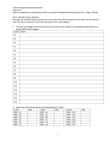
LEED for Neighborhood DevelopmentActivity #3Before completing this Activity Read: Reference Guide for Neighborhood Development v4 – Pages 169-304Fill-In, Multiple Choice, MatchingAlthough the LEED ND reference guide does not number the LEED prerequisites and credits, for this exercisethey have been numbered in the order presented in the credit category.1. Test your knowledge of how well you know the names of the credits for the Neighborhood Pattern andDesign (NPD) credit category:Credit NameP1P2P3C1C2C3C4C5C6C7C8C9C10C11C12C13C14C152. Match the intent shown below to the prerequisite or credit:CreditANSCreditANSNPD – P1NPD – C4NPD – P2NPD – C5NPD – P3NPD – C6NPD – C1NPD – C7NPD – C2NPD – C8NPD – C3NPD – C91CreditNPD – C10NPD – C11NPD – C12NPD – C13NPD – C14NPD – C15ANS
ABCDEFGHIJKLMNOPINTENTTo encourage responsiveness to community needs by involving the people who live or work in thecommunity in project design and planning and in decisions about how the project should beimproved or changed over time.To reduce energy consumption, pollution, and harm to human health from motor vehicles byencouraging multimodal travel.To promote projects that have high levels of internal connectivity and are well connected to thecommunity. To encourage development within existing communities that promote transportationefficiency through multimodal transportation. To improve public health by encouraging daily physicalactivity.To reduce vehicle distance traveled and automobile dependence, encourage daily walking, biking,and transit use, and support car-free living by providing access to diverse land uses.To encourage walking and bicycling and discourage speeding. To reduce urban heat island effects,improve air quality, increase evapotranspiration, and reduce cooling loads in buildings.To conserve land and promote multimodal transportation by encouraging development withinexisting communities that have high levels of internal connectivity and are well connected to thelarger community. To improve public health by encouraging daily physical activity and reducingmotor vehicle emissions.To minimize the environmental harms associated with parking facilities, including automobiledependence, land consumption, and rainwater runoff.To encourage transit use and reduce vehicle distance traveled by providing safe, convenient, andcomfortable transit waiting areas.To promote community interaction and engagement by integrating schools into the neighborhood.To improve students’ health by encouraging walking and bicycling to school.To promote socially equitable and engaging neighborhoods by enabling residents from a wide rangeof economic levels, household sizes, and age groups to live in a community.To enhance community participation and improve public health by providing recreational facilitiesclose to work and home that facilitate physical activity and social networking.To provide open space close to work and home that enhances community participation andimproves public health.To promote transportation efficiency and reduce vehicle distance traveled. To improve public healthby providing safe, appealing, and comfortable street environments that encourage daily physicalactivity and avoid pedestrian injuries.To promote the environmental and economic benefits of community based food production andimprove nutrition through better access to fresh produce.To increase the proportion of areas usable by a wide spectrum of people, regardless of age or ability.To conserve land. To promote livability, walkability, and transportation efficiency and reduce vehicledistance traveled. To leverage and support transit investments. To improve public health byencouraging daily physical activity.3. Neighborhood Pattern and Design emphasizes the creation of ,, mixed-use neighborhoods with good connections to nearby communities.4. List features that increase pedestrian activity:1.4.2.5.3.6.2
5. Public spaces, such as parks, plazas, and playing fields, can encourage interaction andactive recreation while helping control runoff and reducing urbaneffects.6. NPD Prerequisite: Walkable StreetsRequirementsDesign and build the project to achieve all of the following:a. of new buildings have a entry onto thenetwork or other public space, such as a park or plaza, but not a lot. Whetheropening to the circulation network or other public space, the functional entry must be connected to aor equivalent provision for walking. If the public space is a square, park, orplaza, it must be at least feet (15 meters) deep, measured at a point perpendicular to eachentry.b. At least of the block length of the existing and new circulation networks within andbordering the project has a building-height-to-street-centerline ratio of(i.e., a minimum of foot [300 millimeters] of building height for everyfeet [450 millimeters] of width from street to building façade).Alleys may be omitted from the calculations.o Projects that a part of the circulation network must meet only theirproportional share of the height-to-width ratio (i.e., only on the project side of the circulationnetwork).o Building is measured to eaves or, for a flat-roof structure, to the rooftop. Forbuildings with multiple heights or widths, use heights or widths weighted byeach portion’s share of the total height or width.c. Continuous or equivalent all-weather routes for walking are provided alongsides of of the circulation network length within theproject, including the project side of circulation network bordering the project. Bicycle- and pedestrianonly paths this requirement. New sidewalks must be at least feet (2.5meters) wide on retail or mixed-use blocks and at least feet (1.2 meters) wide on all otherblocks.d. No more than of the block length of the circulation network within the project is faceddirectly by and service bay openings. may be omitted fromthe calculations.Portions of projects containing buildings or contributing buildings in a designatedhistoric district subject to review by a local historic preservation entity are from (b),(c), and (d) if approval for compliance is not granted.Portions of projects containing buildings or contributing buildings in historic districtslisted in or eligible for listing in a state provincial, or regional register, or the National Register of HistoricPlaces that are subject to review by a state historic preservation office or the National Park Service (or localequivalent for projects outside the U.S.) are from (b), (c), and (d) if approval forcompliance is not granted.3
Residents of highly neighborhoods drive nearly fewer miles (kilometers)than their counterparts in the least walkable neighborhoods; they thereby reduce traffic-related emissionsby as much as 2,000 grams of dioxide per person per day while increasing theirphysical fitness, social interaction, and neighborhood safety.List strategies to improve a neighborhood’s walkability:1.2.3.4.A zone, such as parking or a planting strip between thesidewalk and the street, can greatly enhance a sidewalk’s walkability.7. NPD Prerequisite: Compact DevelopmentRequirementsDesign and build the project to meet the specified below.densities must be met for both (1) the project at full build-out and (2) theof the project that will be built within years of the date that thenew building of any type is occupied.Case 1. Projects with Access to Quality TransitFor projects with existing or planned transit service (i.e., service with the funding commitments as specifiedin SLL Prerequisite Smart Location) that meets or exceeds the -point threshold in SLL CreditAccess to Quality Transit, build at the following densities, based on the walking distances to the transitservice specified in that SLL credit: for residential components located within the walking distances: or more dwelling buildableland units per acre (30 DU per hectare) of buildable land available for residential uses; for residential components falling outside the walking distances: or more dwelling units peracre (17.5 DU per hectare) of buildable land available for residential uses; for nonresidential components located within the walking distances: or higher floor-arearatio (FAR) for the buildable land available for nonresidential uses; and for nonresidential components falling outside the walking distances: or higher FAR for thebuildable land available for nonresidential uses.If the project location is served by a transit agency whose guidelines for minimum service densities arethan the densities required by this prerequisite, the projectachieve those service densities instead.Case 2. All Other ProjectsBuild any components of the project at a density of or moredwelling units per acre (17.5 DU per hectare) of available for residential uses.Build any components of the project at a density of or higherFAR for the buildable land available for nonresidential uses.4
For All ProjectsDensity calculations include all and buildings within the projectboundary, excluding those portions of parking devoted exclusively to parking.If the component of the project meets the minimum density requirement but thecomponent does not, or vice versa, include only the qualifying density. Usethat component’s dwelling units or nonresidential floor area in the numerator and the total buildable landarea in the denominator. If the resulting density meets the minimum requirement, the prerequisite isachieved.8. NPD Prerequisite: Connected and Open CommunityRequirementsMeet the requirements of Case 1 if the project has no networkintersections within the project boundary and is acres or less in size. All other projects mustmeet Case 2.Case 1. Surrounding ConnectivityLocate the project such that the connectivity within -mile (400 meters) of the project boundary isat least intersections per square mile (35 intersections per square kilometer). Any part of thecirculation network that is counted toward the connectivity requirement must be available for generalpublic use and not . Gated areas are not considered available for public use, with theexception of and care campuses andbases where gates are used for security purposes.Additionally, any network within the project must be available for general public useand not gated.Case 2. Internal ConnectivityDesign and build the project such that its internal connectivity is at least intersections per squaremile (54 intersections per square kilometer).Any part of the network counted toward the connectivity requirementmust be available for general public use at all times and not . Additionally, no morethan of the project area may be accessed via circulation network that is gated. Educationcampuses, health care campuses, and military bases where gates are used for security purposes are exemptfrom the limit, and within those projects may betoward the connectivity requirement.Design and build the project with at least through-connection (of the circulation network)intersecting or terminating at the project boundary at least every feet (245 meters), or atexisting abutting intervals and intersections of the circulation network, whichever is the shorter distance.These requirements do not apply to portions of the boundary where connections cannot be made becauseof physical , such as prior platting of property, construction of existing buildings orother barriers, slopes steeper than , railroad and utility rights-of-way, existing limited-accessmotor vehicle rights-of-way, and parks and dedicated open space.A circulation network—well-connected pedestrian, bicycle, and vehicular routes—andblock sizes provide direct, efficient routes for walking and bicycling to nearby destinations.5
A intersection density is one of the single most important factors for increased levelsof walking, as well as for increasing transit use and reducing vehicle distance traveled.9. NPD Credit: Walkable StreetsRequirementsA project may earn a maximum of points, awarded according to Table 1.Façades and Entriesa. At least of the total linear distance of building façades facing the circulation network in theproject is no more than feet (7.5 meters) from the property line.b. At least of the total linear distance of building façades facing the circulation network in theproject is no more than feet (5.5 meters) from the property line.c. At least of the total linear distance of mixed-use and nonresidential building façades facingthe circulation network in the project is within foot (300 millimeters) of a sidewalk orequivalent walking route.d. Functional entries to the building occur at an average of feet (23 meters) or less alongnonresidential or mixed-use buildings or blocks.e. Functional entries to the building occur at an average of feet (9 meters) or less alongnonresidential or mixed-use buildings or blocks.Items (d) and (e) are cumulative.Ground-Level Use
Although the LEED ND reference guide does not number the LEED prerequisites and credits, for this exercise they have been numbered in the order presented in the credit category. 1. Test your knowledge of how well you know the names of the credits for the Neighborhood Pattern and Design (NPD) credit category: Credit Name P1 . P2 . P3 . C1 . C2 . C3 . C4 . C5 . C6 . C7 . C8 . C9 . C10 . C11 .