Transcription
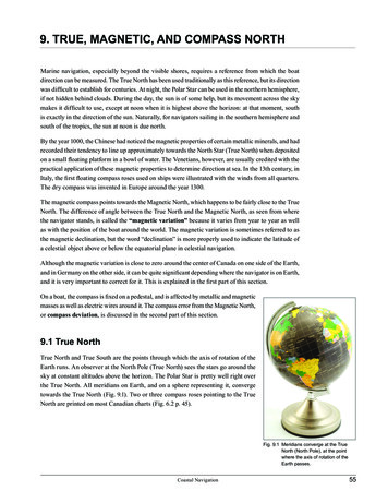
9. TRUE, MAGNETIC, AND COMPASS NORTHMarine navigation, especially beyond the visible shores, requires a reference from which the boatdirection can be measured. The True North has been used traditionally as this reference, but its directionwas difficult to establish for centuries. At night, the Polar Star can be used in the northern hemisphere,if not hidden behind clouds. During the day, the sun is of some help, but its movement across the skymakes it difficult to use, except at noon when it is highest above the horizon: at that moment, southis exactly in the direction of the sun. Naturally, for navigators sailing in the southern hemisphere andsouth of the tropics, the sun at noon is due north.By the year 1000, the Chinese had noticed the magnetic properties of certain metallic minerals, and hadrecorded their tendency to line up approximately towards the North Star (True North) when depositedon a small floating platform in a bowl of water. The Venetians, however, are usually credited with thepractical application of these magnetic properties to determine direction at sea. In the 13th century, inItaly, the first floating compass roses used on ships were illustrated with the winds from all quarters.The dry compass was invented in Europe around the year 1300.The magnetic compass points towards the Magnetic North, which happens to be fairly close to the TrueNorth. The difference of angle between the True North and the Magnetic North, as seen from wherethe navigator stands, is called the “magnetic variation” because it varies from year to year as wellas with the position of the boat around the world. The magnetic variation is sometimes referred to asthe magnetic declination, but the word “declination” is more properly used to indicate the latitude ofa celestial object above or below the equatorial plane in celestial navigation.Although the magnetic variation is close to zero around the center of Canada on one side of the Earth,and in Germany on the other side, it can be quite significant depending where the navigator is on Earth,and it is very important to correct for it. This is explained in the first part of this section.On a boat, the compass is fixed on a pedestal, and is affected by metallic and magneticmasses as well as electric wires around it. The compass error from the Magnetic North,or compass deviation, is discussed in the second part of this section.9.1 True NorthTrue North and True South are the points through which the axis of rotation of theEarth runs. An observer at the North Pole (True North) sees the stars go around thesky at constant altitudes above the horizon. The Polar Star is pretty well right overthe True North. All meridians on Earth, and on a sphere representing it, convergetowards the True North (Fig. 9.1). Two or three compass roses pointing to the TrueNorth are printed on most Canadian charts (Fig. 6.2 p. 45).Fig. 9.1 Meridians converge at the TrueNorth (North Pole), at the pointwhere the axis of rotation of theEarth passes.Coastal Navigation55
9. TRUE, MAGNETIC, AND COMPASS NORTHS9.2 Magnetic NorthThe movement of lava along loops above the iron core of the Earth causes a flow of electricity which,in turn, generates magnetic fields. The lines of force, in these magnetic fields, emerge from the Earth inthe area called Magnetic North (M); they diverge around the Earth, and return at the Magnetic South,not very far from the South Pole, at the edge of the Antarctic Continent nearest to Tasmania (Australia).Since the loops of lava are fluid, the magnetic field varies slightly from year to year, and occasionallyreverses itself. During the past few thousand years, the Magnetic North has been in NorthernCanada. For the past few hundred years, it has been moving towards the NNW at the rate of about50 km per year. In 1831, the Arctic explorer James Ross established its position along the centralCanadian Arctic Coast, at the foot of the Boothia Peninsula. More recently, it was further north andslightly west, near Resolute Bay. By 2010, it was over the ice cap, some 400 km to the NW of EllesmereIsland (Fig. 9.2).77 Teru60 MacetignFig. 9.2 The True and Magnetic poles.Fig. 9.3 The True and Magnetic Norths. Within each compass roseprinted on a marine chart, the magnetic compass rose is a regularcompass rose rotated until its zero points towards the MagneticNorth. Any bearing measured with a hand bearing compass, i.e. offthe magnetic north (i.e. 60º M), needs to be adjusted by the magnetic"variation" before it can be plotted on a chart, on which angles aremeasured off the True North (77º T). The variation, east or west, isthe angle from the True North to the Magnetic North (17º E).9.2.1 Conversions between True North and Magnetic NorthOn the chart, the navigator plots the tracks of the boat in degrees True, counted from the True North.The helmsperson, on the other hand, needs a direction in degrees Magnetic, counted from the MagneticNorth, in order to be able to steer the boat by the magnetic compass. Conversely, the navigator takesbearings in degrees magnetic from landmarks with a hand bearing compass, and needs to convertthese into degrees True in order to plot the lines of position on the chart and determine where the boatis (Fig. 9.3).56Coastal Navigation
9. TRUE, MAGNETIC, AND COMPASS NORTHSConversions between true and magnetic degrees are thus done frequently, and exact calculations areessential to avoid gross errors in position. Since navigators are often tired and frequently trying to workin a rather miserable environment, they are subject to human errors, and best rely on a mechanicaland systematic method of calculations not requiring any profound thinking. Experience shows thatby-passing the simple method described below in order to make full use of one’s extended knowledgein mathematics and brilliant intelligence, leads to what the navigators themselves call “stupid errors”,which can result in icVariation20 EastofrseMagneticVariation15 WestMagneticate BoCouTrueCoursthCourserseCouheof ttBoaeseurMagneticCoTrueCoursTrueNortheFig. 9.4 Magnetic Variation East (least):Magnetic Course True Course - Variation.Fig. 9.5 Magnetic Variation West (best):Magnetic Course True Course Variation. When Magnetic North M is east of the True North (Variation V is east; Fig. 9.4), as it is the casein Western Canada, the Magnetic Course MC of the boat can be calculated from its True CourseTC measured on the chart, by applying the formula:MC TC – Variation East (Fig. 9.4) i.e. Magnetic Course True course minus the Variation East. In other words, when switchingfrom True to Magnetic, and only when switching from True to Magnetic, East is Least. When Magnetic North M is west of the True North (Variation V is West; Fig. 9.5), as it is the casein Eastern Canada, the Magnetic Course MC of the boat can be calculated from its True CourseTC measured on the chart, by applying the formulaMC TC Variation West (Fig. 9.5) i.e. Magnetic Course True Course plus the Variation West. In other words, when switching fromTrue to Magnetic, and only when switching from True to Magnetic, West is Best. In summary:Coastal Navigation57
9. TRUE, MAGNETIC, AND COMPASS NORTHS9.3 Compass NorthThe boat compass should point to Magnetic North. However, it is affected by local metallic and magneticmasses as well as electric wires in the cockpit. This introduces small errors which vary depending onthe heading of the boat. The error is the compass deviation, which vary from a few degrees east to afew degrees west of Magnetic North as the boat turns around.TrueNorthThe same calculations as in section 9.2.1 (conversionof True North to Magnetic North) apply to conversionsfrom Magnetic North to Compass North: When the compass deviation is east of the MagneticNorth (east deviation D), the Compass Course CCof the boat can be calculated from the MagneticCourse MC by applying the formula:MagnetiVariati con20 EastMaNo gneticrthComDe pas5 E viatio sast nCompaseurCoss9.3.1 C onversions between MagneticNorth and Compass NorthCompDev assia6 W tionestherCouftse otBoaFig. 9.6 C ompass deviation, east or west of theMagnetic North depending on the orientationof the boat.CC MC – Deviation East i.e. Compass Course Magnetic Course minus the Deviation East of the compass. In other words,when switching from Magnetic to Compass, and only when switching from Magnetic to Compass,East is Least. When the compass deviation is west of the Magnetic North (West Deviation D), the CompassCourse CC of the boat can be calculated from its Magnetic Course MC by applying the formulaCC MC Deviation West i.e. Compass Course Magnetic Course plus the Deviation West of the compass. In other words,when switching from Magnetic to Compass, and only when switching from Magnetic to Compass,West is Best. In summary:58Coastal Navigation
9. TRUE, MAGNETIC, AND COMPASS NORTHS9.3.2 Compass Deviation Table and GraphThe compass deviation from Magnetic North depends on the boat's heading. As various metal partssuch as winches, or magnetic masses such as loudspeakers, as well as electric cables such as the onesbringing lights to the cockpit, pass in front of the compass when the boat turns around, the compassneedle is slightly deflected to the left or to the right of the Magnetic North.Swinging of the compass consists of measuring the compass deviations as a function of its headingthroughout a full rotation of 360 , and then minimizing these deviations through the use of smalladjustment screws marked N-S and E-W on the sides of the compass. This procedure is best left toprofessionals. It is usually conducted in a quiet area of the harbour, and should be repeated wheneverthe cockpit configuration changes.The compass deviation, is traditionally recorded as a function of the boat direction, either in a compassdeviation table (Fig. 9.7), or in a compass deviation graph (Fig. 9.8):Note that, in theexample given inFig. 9.6 and 9.7,the swinging of thecompass was not donevery well: the overalldeviation is mainly tothe west. Some finetuning is required, usingthe adjustment screwsof the compass.Fig. 9.7 Compass Deviation Table.Fig. 9.8 Compass deviation graph, displaying identical information.Coastal Navigation59
9. TRUE, MAGNETIC, AND COMPASS NORTHS9.4 Mnemonics for conversions between True, Magnetic andCompass NorthThe process of conversion from any North to any other is straightforward, and yet most navigatorsmake what they call “stupid errors”, at least initially, adding degrees of variation or deviation insteadof subtracting them, and vice versa. This is because they tend to blindly apply the phrase “East is Leastand West is Best”; yet, the mnemonic sentence is valid ONLY FROM TRUE TO MAGNETIC, ANDONLY FROM MAGNETIC TO COMPASS, i.e. from left to right in the mnemonic relation givenbelow. Hence all the arrows.In other words, if one writes the letters “TVMDC” from left to right, as shown below, the mnemonicphrase “East is least and West is Best” only applies for the calculations from left to right.T (True course);V (Variation of the Magnetic North, either East or West);M (Magnetic course);D (Deviation of the compass, either East or West); andC (Compass course)The sequence of calculations is easily remembered with the use of the mnemonic phrase:“T V Makes Dull Children”.Other mnemonic phrases are used, usually by young sailors whose mind is affected by relatively highlevels of testosterone, but these would be politically incorrect, and cannot be reproduced in such aconservative and traditional document.Conversion of directions from True to Compass courses thus involves two steps:1. Knowing the true course T to be followed by the boat, as measured on the chart from the True North,the navigator subtracts the magnetic variation V if it is east (East is Least) or adds it if the Variationis west (West is Best) to obtain M, the Magnetic course. This is the course which would be followedwith a perfect compass, i.e. one not influenced by metal masses or electric wires around the cockpit.60Coastal Navigation
9. TRUE, MAGNETIC, AND COMPASS NORTHS2. S ince the boat compass always has some error, i.e. a small deviation, further calculations must bemade to correct for compass deviation. Having calculated the magnetic course of the intended trackby applying the local magnetic variation, the navigator subtracts the compass deviation D if it iseast (East is Least) or adds it if it is west (West is Best) to obtain C, the Compass course. This isthe course to be followed on the boat compass.Example 1:A skipper wishes to follow a course of 240 True (T 240), along the West Coast where the MagneticNorth is 17 to the east of the True North (V 17 east). What is the compass course to follow, given thecompass deviation table given in Fig. 9.7.We place the numbers which we know under to letters TVMDC:T240VMDC17E (-)Since we are doing the calculation from left to right, the Variation of 17 east must be subtracted (Eastis Least from left to right). The Magnetic course M is 240 – 17 223 (column M):TVM24017E (-)223DCWhen the boat follows a magnetic heading of 223 M, the deviation table (Fig. 9.7) shows a compassdeviation of 3 E. We write the deviation 3 E in the column D:TVMD24017E (-)2233E (-)CAgain, since we are doing the calculation from left to right, the deviation of 3 east must be subtracted(East is Least from left to right):TVMDC24017E (-)2233E (-)220The compass course C is 223 - 3 220 (column C). The helmsperson needs to follow a course of220 on the boat compass to maintain a true course of 240 .Coastal Navigation61
9. TRUE, MAGNETIC, AND COMPASS NORTHSExample 2:Sometimes, we follow a compass heading C and wonder what the true course T of the boat might be.More frequently, we take a bearing with the hand bearing compass. We assume that we keep our handbearing compass away from ferrous masses and electric wires or magnets so that it has no deviation:our measure of the angle between the Magnetic North and a landmark is thus in degrees magnetic, M.If we want to plot this bearing on a chart, we need to convert it to degrees true, T. For example, wetake a magnetic bearing of 060 on a landmark in Newfoundland, where the local magnetic variationis V 20 W. We want to plot the corresponding line of position (Chapter 10, p. 63).In order to apply the same mnemonics (East is Least and West is Best), we need to make sure ourcalculations are done from left to right. In other words, we need to guess at the number T which, givenour known local Variation V of 20º W, will give us the hand compass bearing M.TVM?20W ( )DC060The process involves two steps.1. W e take an educated guess at the number which we think, in column T, would result in a Magneticheading of 60 if we did the calculation from left to right, and added the Variation W (West is Best)of 20 to T. We think that T should be 40 .2. We verify, from left to right, that our guess was right, especially its sign:TVM4020W ( )DC06040 20 W 060 indeed. Our educated guess was right. This verification is necessary given thetraditional frequency of erroneous guesses. The most common mistakes are either a wrong sign, ora guessed number off by 10 . Experience with hundreds of students over some 15 years shows thatguesses are wrong about half the time at sea, as would be expected with sailors who are stressed andtired, and who thus do not have full use of their vast knowledge and sharp mind. Guesses in class area little better. It is thus essential to carefully verify the guess, and in particular its sign.Example 3:We might know our true course, for instance by following a range marked in degree True on the chart,and also know our magnetic heading, for instance from our hand bearing compass which has no deviationerror. We can then measure the local magnetic variation:TVM245?228DCLooking at the data from left to right to use the rule “West is Best and East is Least,” we cancalculate the magnetic variation as 245º - 228º 17º E. Similarly, knowing M and C, we could calculatethe compass deviation D. If we read, for example, C 230º on the boat compass, we can tell thatD 2º W since 228º M 2º W 230º C.62Coastal Navigation
In 1831, the Arctic explorer James Ross established its position along the central Canadian Arctic Coast, at the foot of the Boothia Peninsula. More recently, it was further north and slightly west, near Resolute Bay. By 2010, it was over the ice cap, some 400 km to the NW of Ellesmere . i.e. Magnetic Course