Transcription
Parcels, Addresses andGeocodingPresented By:Howard Botts, PhDVP of Geospatial Database DevelopmentSteve EggeDirector of Emerging MarketsAlan TeicherDirector of Telcom SalesEmail ateicher@corelogic.comPhone 847-821-7051 2012 CoreLogic. Private & Confidential
CoreLogic A leader doing business with leaders Demonstrated stability during current downturn 1.6 billion in revenue (2012) More than 5,000 employees More than 40,000 clients, including the top 100 mortgagelenders, 90 percent of capital market firms, 5 of the top 10insurers Financial strength and strategic client focus CLGX Stock Symbol Split from First American Corporation in June 2010,establishing a new, independent public corporationthat provides:Services Unparalleled Information Advanced Analytics Customized ServicesAnalytics We deliver insight into your business that: Reduces risk Improves performance 2012 CoreLogic. Private & ConfidentialData
Unparalleled Data AssetsPublic Record Data – Aggregated Standardized. Digitized.PropertyDatabase Property & LienInformation Coveringover 99% USpropertiesCriminalDatabase Defendant, Alias,Offense and Dispositiondetails on 335MrecordsProperty Tax,Flood and GeoSpatial Database Tax payment history on145 mm parcels. Geocoded parcel maps120mm . National FloodcoverageData Acquired From Third PartiesCredit History 25 million credit reports provided per yearto lenders, auto dealers and other clients Provider of “Tri-merge” credit reportbased on data obtained from creditbureausProprietary DataDelinquency andPrepay DataAsset &Mortgage BackedSecurities Data Servicing Data covering85% of US HomeLoans Covering 98% of allNon –Agency MBSDeals 50MM Active Loans; 6.8T in Balances 5.7MM Active LoanRecords; 1.47Tln ofBalances 2012 CoreLogic. Private & ConfidentialMultiple ListingService DataUnder-BankedBorrower’s Data Realtor submitted homedata on 3/4 of allresidential transactions.51M historical records3.5 M Active Data from PayDayLenders, Rent to OwnCompanies and VariousOther SubPrimeLenders Property detail, askingprice and sales pricedata. Plus propertyphotos Payment Histories,Open and Paid loans.250MM records on40MM consumersMulti -Family/Tenancy Checks Data from landlordsand owners of multifamily properties Nation’s largestprovider of tenantbackground checks
Digital Parcel Data Provides the Solution Base ForInnovative Telecom Applications What is parcel data? Challenges to building a parcelland base. Parcel based versus Postalbased geocoding issues. Telecom case study. 2012 CoreLogic. Private & Confidential4
What is Parcel Data? Parcel boundary data represents the legalextents of each taxable U.S. propertyaddress. There are an estimated 144.3 millionprivately owned parcels in the U.S. CoreLogic has converted and normalizedabout 134 million parcels from state,county, city, and town sources As these digital parcel boundariesbecome available they are rapidly beingincorporated into applications to enhance:oGeocoding accuracyoRisk assessmentoRisk concentrationoMany other uses where “granular”accuracy is important. 2012 CoreLogic. Private & Confidential
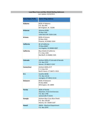
GeocodeLatitudeLongitudeAddress LineCity/State ZipPxPoint Data Set25.898951-80.126806276 BAL BAY DRMIAMI BEACH FL 33154PARCELElevation, Slope, and AspectElevation (Feet)Slope (Degrees)Aspect1.310FlatMainland Determination & DistanceDistance to Seaward Water FeatureSeaward Water Feature NameMainland: Yes or No101 feetBiscayne BayNoCoastal Storm SurgeRisk ValueRisk Level5ExtremeHurricane Landfall Probability% Tropical Storm Risk (Winds 39 - 73mph)% Tropical Storm Risk (50-yr)% Hurricane Risk (Cat 1-5 Storms)% Hurricane Risk (50-yr)% Intense Hurricane Risk (Cat 3-5 Storms)% Intense Hurr. Risk (50-yr)5.393.51.656.30.419.9Flood RiskFlood Hazard ZoneUndeveloped Coastal Barrier AreaSpecial Flood Hazard Area (SFHA)AECOBRA OUTINDamaging WindsStraight Line Wind (SLW) RiskSLW FrequencyHurricane RiskHurricane FrequencyTornado RiskTornado FrequencyModerate1 Event Every 4 - 6 YearsVery High1 Event Every 3 - 5 YearsModerate1 Event every 5 - 8 YearsSinkholeRiskDistance to Very High Sinkhole RiskLowGreater than 10 milesWildfire RiskBrushfire RiskNearest high-risk valueDistance to High/Very HighUrbanVery High 1 mile 2012 CoreLogic. Private & ConfidentialParcels As The Relational Link The Parcel IdentificationNumber (PIN) or Address links thephysical parcel to real estate data;and Latitude/Longitude links thehazard risk and reg. compliancedata to the parcel.Parcel InformationPIN:Address Line:City/ State/ Zip:Latitude:Longitude:1222260022310276 BAL BAY DRBAL HARBOUR FL 3315425.898951-80.126806PIN:Property Address:Owner:Land Value:Building Value:Market Value:Assessed Value:Adj Sq Footage:Year Built:Bedrooms:Baths:Stories:Living Units: 2Adj Sq Footage:Lot Size (Sq Ft):Year Built:Construction:Pool:Roof Cover:1222260022310276 BAL BAY DRBEV SIEVERT 9,892,934 2,349,327 12,242,261 9,375,0669,9881977910229,98846,2791977CompositeIn GroundTile
2012 CoreLogic. Private & Confidential
10 Challenges To Building A Land Base UsingParcel Data1. CoreLogic collects from over 4,400 county/municipal sources to maintain2,391 Counties (counties, cities, towns, villages etc).2. Collection entities is often local government officials of widely variabledegrees of sophistication and responsiveness – collection can take hours – ormonths – or years depending on the source.3. Many data formats are received and every county has their own specificschema – there is not a standard schema that all counties/communities use.4. Schema’s must be standardized, and standardized correctly in order to makethe data useable.5. Data is of varying accuracy from a spatial perspective and geographicidiosyncrasies must be dealt with – in a consistent manner. 2012 CoreLogic. Private & Confidential
10 Challenges To Building A Land Base UsingParcel Data6. Local data projections are utilized and must be normalized to operate in awider area.7. CoreLogic has patented technology to do all the above in an efficient andconsistent manner.8. Legal restrictions on the data must be considered – not all data can be usedas it desired without negotiation and in some cases legal amendment ofexisting agreements.9. Maintenance of the file requires the process start all over again.10. Finally – CoreLogic doesn’t just create this data as a product – we are utilizingit in our internal operations – this means that we got it right and we arecommitted to quality – we just don’t get quality complaints - the issues havebeen dealt with – because they we had to for the sake of our business. 2012 CoreLogic. Private & Confidential
Parcel Alignment Boundary Layers arealigned to parcel data 2012 CoreLogic. Private & Confidential
Street Centerline and Aerial Imagery During the alignmentProcess, aerialimagery and streetcenterlines are alsoreferenced. 2012 CoreLogic. Private & Confidential
AlignmentSource data is misaligned 2012 CoreLogic. Private & Confidential
AlignmentStreet AlignedParcel AlignedReference aerial imageryAlignment to all other boundary layers 2012 CoreLogic. Private & Confidential
Parcel Data for Infrastructure 2012 CoreLogic. Private & Confidential
Property Tax Compliance 2012 CoreLogic. Private & Confidential
Provide Information to Project Engineers toLocate Features or Identify UnsuitableEnvironmentsWetlands 2012 CoreLogic. Private & ConfidentialEndangered SpeciesCorridors(CA Gnatcatcher)School Yards
PxPoint Geocoding A multi-national, state-of-the-artgeocoding and spatial analysis librarysuitable for high-precision, high-volumeapplications. Accesses all available geospatial datafrom vendors such as NAVTEQ andTeleAtlas ,including: Street addresses, Parcel-level data and intersections,and Data collected and managed byclients (e.g. new streets). Full GIS functionality build into thegeocoder for example: Point to Point, Line or Polygon, Point in Polygon Polygon on Polygon Buffering Proximity 2012 CoreLogic. Private & Confidential
The Importance of Geocoding AccuracyGeocode Difference Example, South CarolinaCoreLogic Geocode7421 Charleston HwyBowman, SCClient Geocode7421 Charleston HwyBowman, SC 2012 CoreLogic. Private & Confidential
Examples of Why Parcels Are Important For AccurateGeocoding (Street Interpolation vs. Parcel Geocode) 2012 CoreLogic. Private & Confidential
Example of Geocoding Offset When Using aCASS Address Instead of the Actual Address 2012 CoreLogic. Private & Confidential
9 Digit ZIP Centroids vs. Parcel Matches 2012 CoreLogic. Private & Confidential
5 Digit ZIP Centroids vs. Parcel Matches 2012 CoreLogic. Private & Confidential
CoreLogic OverviewCase Study Determining spatial accuracy. What is the enterprise economic and regulatory impactof spatial accuracy. What are the functional areas that are impacted by spatialaccuracy. What is the Return On Investment to the Enterprise. 2012 CoreLogic. Private & Confidential
Network Addressability Normalized/Standardized land base: Provides spatial accuracy across the enterprise resulting ineconomic and regulatory benefits to Marketing, IT, Engineering,Finance, and Treasury. Delivers an enterprise spatial continuity; a process, method, anddiscipline throughout the enterprise accessible by all. Accurate service level determinants: Delivers new revenue sources.Enhanced customer service.Reduces engineering costs.Provides provisioning and inventory benefits.Improved sales use and property tax determinants.Local Franchise Authority Compliance. 2012 CoreLogic. Private & Confidential
2012 CoreLogic. Private & Confidential
2012 CoreLogic. Private & Confidential
2012 CoreLogic. Private & Confidential
2012 CoreLogic. Private & Confidential
2012 CoreLogic. Private & Confidential
Economic Impact Ongoing Expenses Labor Costs Acquire data from governments. Normalize and align data; parcels & boundaries throughout areaof interest and provide spatial accuracy continuity andstandardization of data. Training costs. Cost to acquire data from governments year over year Initial cost to acquire data, Ongoing cost to maintain data Timeliness of data updates, Frequency of data updates Integration, Implementation, and Conflation costs forenterprise use. Ensuring legal usage, Speed of access to the data along with currency ofupdated data. 2012 CoreLogic. Private & Confidential
Case Study # 2 Spatial accuracy impact on Sales / Use tax Building a defendable process against audits. 2012 CoreLogic. Private & Confidential
Case Study Sample Address Locations ZIP 4 Geocode does not match CoreLogic Parcel Geocode 964 municipal tax jurisdictions do not match 2012 CoreLogic. Private & Confidential
Case Study Sample Address Locations ZIP 4 Geocode does not match CoreLogic Parcel Geocode 1,460 township tax jurisdictions do not match 2012 CoreLogic. Private & Confidential
Spatial Accuracy Requires A USPS data base for address standardization A street file with address ranges Normalized and Standardized Parcel Shape files and County,Municipal, and Township Boundaries. Parcel Centroid. Dedicated team internally to maintain spatial continuity throughoutthe enterprise. 2012 CoreLogic. Private & Confidential
QuestionsAlan TeicherDirector Of relogic.com 2012 CoreLogic. Private & Confidential
PxPoint Geocoding A multi-national, state-of-the-art geocoding and spatial analysis library suitable for high-precision, high-volume applications. Accesses all available geospatial data from vendors such as NAVTEQ and TeleAtlas ,including: Street addresses, Parcel-level data and intersections, and Data collected and managed by