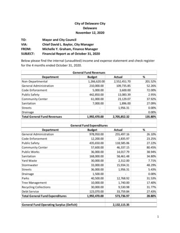
Transcription
Geology of the Delaware BasinGuadalupe, Apache, and Glass MountainsNew Mexico and West TexasCarol HillAlbuquerque, New MexicoEDITORSRobert F. Lindsay and Raymond A. GarberTECHNICAL EDITORSJim W. Adams - HistoryJ. Fredrick (Rick) Sarg - Stratigraphy (Precambrian toDavid M. Rohr - Stratigraphy (Glass Mountains)Spencer G. Lucas - Stratigraphy (Mesozoic)John W. Hawley - Stratigraphy (Cenozoic)Denise H. Mruk - DiagenesisThomas E. Ewing - Structural GeologySteven M. Cather - TectonicsRobert M. Holt - HydrologyHarvey R. DuChene - CavesRoger Y. Anderson - DissolutionFred M. Phillips - GeochemistryRonald F. Broadhead - Oil and GasJoseph E. Crawford - SulfurVirginia T. McLemore - Sulfide/Barite/FluoriteGeorge S. Austin - PotashPermian Basin Section - SEPMPublication No. 96-39Samson ExhibitNMOCD Case Nos. 13492/13493Submitted 8/10/06
32PART I: SEDIMENTSSTRATIGRAPHYOver one billion years of rock record is preserved in theDelaware Basin area. Rocks and sediments range in age from1.3 by for the Precambrian basement to less than 10,000 ybpfor Holocene sediments in the Pecos River Valley. A numberof these stratigraphic units are source or reservoir rocks foroil and gas and recovery from these units has made theDelaware Basin one of the major hydrocarbon-producingregions in the world. Also among these units is the CapitanLimestone, the classic locality of an ancient reef andvisitation site for scores of geologists over the last century.The overall stratigraphy ofthe Delaware Basin study areais shown diagrarnmatically in Fig. 8. Thickness of thesestratigraphic units varies considerably throughout the studyarea and in some localities certain of these formations pinchout, are eroded away, or were never deposited.The stratigraphy section will be presented in the followingorder:(1) From oldest (Precambrian) to youngest (Quaternary).(2) For each period of geologic time, the GuadalupeMountains section will be discussed first and the geology ofthe other regions (e.g., Apache Mountains, Glass Mountains)will be compared to the Guadalupe Mountain section. Thereason for this is because the geology of the GuadalupeMountains has been more thoroughly studied than thegeology of other sections.(3) For each period of geologic time, the discussion ofstratigraphy will proceed counterclockwise around theperimeter of the Delaware Basin, from the northwest(Guadalupe Mountains) to the west, south, east, and north;then basinal rocks of the same age will be discussed.(4) For each period of geologic time where there is abackreef-reef-forereef-basin facies transition, the order ofdiscussion will be from backreef to reef to forereef to basin.(5) As each period of geologic time is presented, problemtopics will be identified and discussed (e.g., for the OchoanCastile Formation the Special topic: Is the Castile Formationa deep-water or shallow-water deposit?).Names/spelling of all series, groups, formations andmembers, formal or informal, were taken from the U.S.Geological Survey (1994) database of stratigraphic nomenclature.ProterozoicPrecambrianThe oldest rocks known from the Delaware Basin arePrecambrian in age. The Precambrian basement has beenencountered in a number of oil and gas wells in the DelawareBasin area; a contour map of the Precambrian basement asdetermined from these wells is shown in Fig. 9.Counterclockwise around the basin, the following Precambrian granitic rock occurrences have been encountered in thesubsurface: (1) biotite-quartz granite from the HumbleHuapache Unit no. 1 well in sec. 35 T23S R22E, EddyCounty (Guadalupe Mountains), at a depth of 3847 m, hasbeen dated at about 1330 Ma (Denison and Hetherington,1969); (2) 25 m of Precambrian granite penetrated by theHumble Antelope Draw no. 1, drilled near the Hovey anticline (Glass Mountain area) (Bloom, 1988); (3) granite andmetamorphosed sandstone cut by stringers of pegmatite oraplite in the Shell-Humphreys well, Pecos County, Texas,located along the crest of the Fort Stockton high on thesoutheastern side of the basin (Jones and Conkling, 1930);and (4) granitic rock in a drill core west of Hobbs, NewMexico (just north of the study area), dated at 1240 Ma(Wasserburg et al., 1962). All of this granitic rock may bepart of the "granite-rhyolite terrain" episode of Adams et al.(1993a).In addition to Precambrian rocks encountered in drillcores, gravity and seismic data indicate that at least part ofthe Delaware Basin (adjacent to the Central Basin Platform)is underlain by layered mafic rocks, the "Pecos maficintrusive suite" (Miller et al., 1995). The suite takes the formof a 3-10 km thick sill containing a dike-like structure thatmay represent the core of a 100 Ma rift. Outcrops ofPrecambrian rocks occur just southwest of the study area inthe Sierra Diablo-Van Horn, Texas region. Some of theoldest rocks in the Van Horn orogenic belt are part of theHazel, Allamore, Carrizo Mountain, and Van Hornsequences. The Carrizo Mountain Group rhyolitic ash-flowtuffs have been dated at 1270 Ma (Rudnick, 1983). Theserhyolites were extruded over sedimentary rocks of even olderProterozoic age, but the former extent and source of thisancient sedimentary pile is not known. In the Van Hom areaa thick mass of ancient Proterozoic sediments was deformedand overridden from the south by a thrust block of CarrizoMountain schist (King, 1940). Precambrian sediments andvolcanic rocks extend considerably to the north of the VanHorn area (Denison and Hetherington, 1969), and it is likelythat they also extend into the study area.Data from both the drill cores and outcrops is scanty, butfrom this data the story of the earliest beginnings of theDelaware Basin can be tenatively pieced together. Adams etal. (1993) reviewed the geology and tectonics of the middleProterozoic igneous rocks in the Carlsbad region; bimodalityof this rock suggest that continental extension took place inthe region between 1215-1075 my ago and was, in part,coincident with the formation of a Midcontinent rift system.Diabases intruded rhyolitic rocks sometime prior to aregional metamorphic event at about 1200-1000 Ma. Thismetamorphic event was part of the Grenville Orogeny/
35A. Early PaleozoicB. Early PermianC. Late Permian(Upper Guadalupian)FIGURE 10—Diagram showing the Delaware Basin area in the Paleozoic: (A) the Tobosa Basin in the Ordovician to Pennsylvanian (afterAdams, 1965), (B) the Permian Basin in the Early Permian (after Hills, 1984a), and (C) the Delaware Basin in the Late Permian (afterWard et al., 1986, and Garber et al., 1989).Simpson Group has been encountered in the subsurface inDodson's Texas American Syndicate no. 1 (515 m thick;Stevens, 1957), and across the Sierra Madera "cryptoexplosion structure" (698-721 m thick; Wilshire et al., 1972).Haigler (1962) and Hayes (1964) described the Simpsonas a greenish to gray, brown, and black shale, containingsome limestone and coarse- to fine-grained sandstone.Marine ostracods, trilobites, and graptolites are commonfossils in this unit (Galley, 1958). Formations (and somesand members) of the Simpson Group are: the Joins, OilCreek (Connell Sandstone Member), McLish (WaddellSandstone Member), Tulip Creek, McKee Sandstone, andBromide (James, 1985; Bureau of Economic Geology, 1989;Fig. 171). All five formations, and two of the sand members(Waddell and Connell), have been recognized from subsurface wells in the area of the Hovey anticline, northwest of theGlass Mountains (Bloom, 1988).Montoya GroupThe Montoya Group of Late Ordovician age unconformably overlies the Simpson Group (Fig. 11 A). The Montoya isa thick (140 m or so) sequence of rock composed of lightgray to medium-dark gray, fine- to medium-crystalline,calcareous dolomite, some units of which are interbeddedwith shale or dark-gray limestone and some units of whichcontain white to very light-gray porcellaneous chert (Haigler,1962; Hayes, 1964). The Montoya carbonate limestonedolomite sequence is dense, impermeable, and non-porous. Inthe Sierra Madera, Glass Mountains area, the Montoyadolomite varies from 46-155 m in thickness (Wilshire et al.,1972)Where the Montoya crops out in New Mexico, theformation has been subdivided (from oldest to youngest) intothe Cable Canyon Sandstone and into the Cutter Formation,Aleman Formation, and Upham Dolomite, although normallythese names are not used in the subsurface (Grant and Foster,1989). The Montoya is 105 m thick in the Texas Richardswell (T20S R32E) and thins to 88 m in the Honolulu Makowell (THS R28E). Along the Hovey anticline, northwest ofthe Glass Mountains, the Montoya consists of 110-140 m ofa lower unit of dolomitic limestone containing minorquantities of chert and shale, and an upper unit of dolomite,chert, and lesser amounts of limestone (Bloom, 1988). It alsohas been encountered in Dodson's Texas American Syndicateno. 1 well in the same area (Stevens, 1957).SilurianFusselman DolomiteDuring the Silurian the axes of the Tobosa Basin weregenerally the sites of relatively deep water where denselimestones and shales were deposited (Fig. 11B). In thisancient basin the carbonate sequence of the FusselmanDolomite was laid down in response to a highstand in sealevel (Canter et al., 1992). The Fusselman was defined byRichardson (1908) who described a 300 m-thick section ofmassive white limestone in Fusselman Canyon, FranklinMountains, West Texas. In the Delaware Basin theFusselman of Lower Silurian age unconformably overlies theMontoya Group of Late Ordovician age with a fairly sharplithologic break. The formation consists almost entirely of
. 36TOBOSA BASINeroded surface with many karst features such as collapsebreccias, cave sequences, and associated cavernous anddissolution porosity (Canter et al., 1992; Fig. 12). Thewidespread occurrence of this exposure surface suggests thatit was related to a platform-wide drop in sea level. Paleokarstis found in the Fusselman throughout the Permian Basinsubsurface and contributes substantially to the reservoirporosity of producing fields (Mazzullo and Mazzullo, 1992).Wristen FormationBSILURIAN, DEVONIAN, ANO MISSISSIPPIANDEARLY PERMIANELATE PERMIANA subsurface interval previously referred to as the"Silurian shale," "Upper Silurian," or "Green Silurian" wasnamed the Wristen Formation by Hills and Hoenig (1979),the type section being described from a well in the Wickettfield, Ward County, Texas. Canter et al. (1992) reported thatthe Wristen Formation is thickest (450 m) in the northeasternpart of the Delaware Basin, but that it thins northward on theNorthwest Shelf and eastward on the Central Basin Platform.The Wristen Formation is primarily a mud- and shale-richrock dominated by dolomite.Following a post-Fusselman lowstand, a major transgression occurred during early Wristen time. First there was a risein sea level followed by a significant sea level fall later in theWristen, then there was another highstand in which thelatest, uppermost intervals of the Wristen were laid down(Canter et al., 1992). The sea level lowstand resulted inexposure and some karstification on a local scale. Thecontact between the Silurian Wristen and overlying LowerDevonian Thirtyone Formation is unconformable (Fig. 12).This unconformity is indicated by erosional truncation andfurther significant regional karst development.FIGURE 11—Conceptual diagram showing the development of theTobosa Basin into the Midland Basin, Central Basin Platform, and DevonianDelaware Basin from the mid-Ordovician to Late Permian. Crosssections across Lea and Eddy Counties, New Mexico. AfterThirtyone FormationCheeseman(1978).white to light-gray, coarse- to medium-crystalline dolomitewhich contrasts rather sharply with the darker-colored andfiner-grained Montoya (Hayes, 1964). Fossils found in theFusselman include Pentamerus, Amplexus, and Favosites. Inthe southeastern, Sierra Madera-Glass Mountains part of thebasin, the Fusselman has been reported to vary between 1550 m in thickness (Wilshire et al., 1972; Bloom, 1988). Inthe Hovey area, the Fusselman is 20 m thick in Dodson'sTexas American Syndicate no. 1 (Stevens, 1957).Regional emergence in the Late Silurian through MiddleDevonian ( 40 my duration) was accompanied by widespreadkarstification (Mazzullo, 1992). Several distinct karst eventsthat affected Silurian/Devonian strata are: (1) top of theFusselman, (2) top of the Wristen, (3) top of the Thirtyone,and (4) pre-Woodford. The contact between the Fusselmanand overlying Wristen Formation represents a majorunconformity and is typically described as an irregular orAt the end of the Silurian and into the early Devonian,shelf carbonates were deposited along the shallower marginsof the Tobosa Basin and dense limestones, cherts, and blackshales accumulated in deeper waters (Fig. 11B). Carbonatedeposits reached over 300 m in thickness during this time(Netherland et al., 1974). The Thirtyone Formation was oneof the carbonate deposits laid down in the Tobosa Basinduring the Early and Middle Devonian (Fig. 8).The name"Thirtyone Formation" was proposed by Hills and Hoenig(1979) for a unit previously known as the "Lower Devoniancherty limestone" or the "Devonian limestone-siliceous." Thetype section was described from a well in Blk. 31, CraneCounty, Texas, where the formation consists of about 300 mof light-colored siliceous and cherty limestone, with an upperinterval composed mostly of crinoid-rich limestone andminor sandy limestone. The "Devonian" in Reeves, southwestern Pecos, and northern Brewster Counties has beendescribed as being almost entirely chert and having athickness of 32-43 m (Bloom, 1988). The "Devonian" is 80 m
38The top and base of the Mississippian limestone is usuallyeasily recognizable in well samples and mechanical logs(Grant and Foster, 1989).The Mississippian in Kalinga Corporation's Margaret no.1 well, along the Hovey anticline in the Glass Mountainsarea, is predominantly a black shale with minor amounts oflimestone. The shale is gray to black, hard, platy, pyritic,organic and very siliceous. The limestone is brown to darkbrown, microcrystalline to very finely crystalline, generallyclean, commonly sandy, and dolomitic (Bloom, 1988). InDodson Texas American Syndicate no. 1, the unit is 52 mthick (Stevens, 1957).The Mississippian limestone in Gaines and AndresCounties reaches 335 m thick. In Humble's Antelope Drawno. 1 it consists of over 76 m of crinoidal limestone, but inKalinga Corporation's Margaret no. 1, 9.6 km southeast ofthe Antelope Draw well, it is only 15 m thick. Thus, overall,Mississippian limestone thins southward over the study area.the end of the Silurian, Early Devonian, and Mississippianperiods.PennsylvanianThe history of the Delaware Basin as a separate eititybegan with the rise of an Early Pennsylvanian medial ridgein the Tobosa Basin, brought about by the Marat tionOuachita orogeny which was the dominant structural eventthat determined the nature of Pennsylvanian sediment ition(Galley, 1984). Movement along zones of weakness inheritedfrom Precambrian faulting (Fig. 9) induced the emergent ofa complex series of fault blocks near the center of the Tc bosaBasin (collectively known as the Central Basin Platform),which divided the Tobosa Basin into the Midland Basin onthe east and the Delaware Basin on the west (Figs. 10E and11C). In the southwestern part of the Central Basin Platform(near Fort Stockton, Texas), coarse, arkosic sandstone, varicolored shale, and subordinate carbonates of Pennsylvj nianBarnett Shaleage cover a large area of the shelf and directly overli; theOverlying the Mississippian limestone is an upper unit, Precambrian basement, the intervening Paleozoic ockscalled the Barnett Shale, consisting of partly silty, brown having been eroded away from the uplifted fault blockshale and containing very fine-grained sandstone and (Mazzullo, 1986). Also during this time tectonic activitysiltstone (Hayes, 1964; Wilshire et al., 1972; Grant and increased on the Diablo Platform to the west of the Dels wareFoster, 1989). The Barnett Shale is on the order of 60-140 m, Basin (Fig. 13), and these rocks were folded, faulted, andthickening somewhat to the west of the Pecos River. In some deeply eroded prior to the transgression of the Permiai sea.places the total thickness of Mississippian strata can reach The highlands which occupied the Apache Mountain area250-335 m (Netherland et al., 1974). In Kalinga subsequent to uplift were stripped down to Ordovician rock,Corporation's Margaret no. 1 well, the Barnett consists of 60 as can be seen in Humble's Reynolds Cattle Company "E no.m of shale with minor units of sandstone and limestone. The 1 well in the Apache Mountains where Permian Wolfe ampshale is gray to dark-gray towards the top, becoming dark- ian beds rest unconformably on the Ordovician Bliss Sandgray or black with depth; the shale is hard, siliceous, stone. In the Sierra Diablo west of the Apache Mountains,subfissile, organic, and very pyritic (Bloom, 1988).Wolfcampian beds rest on Precambrian rocks.In the area of Carlsbad, the top of the Mississippian belowThe Delaware Basin subsided rapidly duringthe "last" or lowest Pennsylvanian sand is called the Chester Pennsylvanian time. Material was eroded from the Pedernalmember, an informal unit which is composed of fine-grained uplift ("Ancestral Rockies"), Diablo Platform, Marathonsandstone, siltstone, argillaceous limestone, and shale Ouchita fold belt (Fig. 13), and other highland areas, and(Andersen, 1976). The Chester interval is usually considered was deposited as thin sequences of sand and shale withto be of Mississippian age, but may actually be the lowest interbedded carbonates on and along the edges of the shelves.part of the Pennsylvanian sequence. The Chester represents A deep, starved, shale basin occupied the central andthe first progradation of clastics from the Pedernal landmass southern parts of the broad Delaware depression throughoutand entrance into pre-delta deposition, and it signals the the Pennsylvanian, and during this period of geologic timebeginning of Pennsylvanian sedimentation in the basin.approximately 600 m of sediment accumulated in the basin.The Barnett Shale was the result of tectonic movement at Within the area of the Northwest Shelf, intrashelf basinsthe onset of the Ouachita orogeny (Gardiner, 1990). Sedi- (such as the Tatum Basin; Fig. 18) formed in the Latementation continued unabated in the Tobosa Basin until the Pennsylvanian as a result of regional tectonism, and theseLate Mississippian, but beginning at that time there was a persisted until the earliest Permian when the basins becametectonic upheaval that would, in the Pennsylvanian, divide filled (Grover. 1993)the Tobosa Basin up into the Midland Basin, Central BasinProvincial scries names for Pennsylvanian rock in thePlatform, and Delaware Basin (Fig. 11C). This ended the study area arc: the Morrowan, Alokan. Des Moinesian,existence of the Tobasa Basin, but during the 200 my or so Missourian. and Virgilian Equivalent formations (groups)from the Ordovician to Late Mississippian, this ancient basin are the Morrow. Atoka. Strawn. Canyon, and Cisco,accumulated as much as 2000 m of dolomite, limestone, respectively From a petroleum standpoint these names areshale, and sandstone — a continuous sedimentary record somewhat arbitrary, being based on a number of log tops andinterrupted only by relatively brief periods of exposure at the facies changes which are difficult to correlate from well toend of Early, Middle, and Late Ordovician time, and again at well (Grant and Foster. 1989) Meyer (1966) indicated a
39limestones, sandstones, shales, and siltstones (James, 1985).Over much of the area it is a fine- to coarse-grained andconglomeratic sandstone and gray shale with someinterbedded limestone and, in the west, it is a red shale andlimestone pebble conglomerate. In the Delaware Basinreference well located in Eddy County, the bulk of thePennsylvanian has been assigned to the Morrow; here, theMorrow interval i
Aug 10, 2006 · the Cable Canyon Sandstone and into the Cutter Formation, Aleman Formation, and Upham Dolomite, although normally these names are not used in the subsurface (Grant and Foster, 1989). The Montoya is 105 m thick in the Texas Richards well (T20S R32E) and thins to 88 m in the Honolulu Mako well (THS R28E). Along the Hovey anticline, northwest of