Transcription
Supplement to MCRB’s Briefing Paper onBiodiversity, Human Rights and BusinessBiodiversity in Myanmar,including Protected Areas andKey Biodiversity AreasNovember 2018 95 1 512613 info@myanmar-responsiblebusiness.org www.mcrb.org.mm
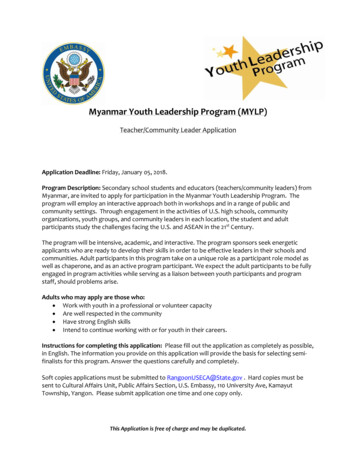
95 1 512613This Supplement to MCRB’s Briefing Paper on Biodiversity, Human Rights and Business inMyanmar gives further information about the biodiversity of Myanmar, its Protected Area (PA)Network and other Key Biodiversity Areas (KBA), which are critically important to protectingbiodiversity and the ecosystem services they provide. It is structured as rb.org.mmMap 1: Ecoregions of MyanmarA. EcoregionsB. Protected Areas of Myanmar and other Areas of Global Significance, including an overviewof coverage representativeness, financing, governance, enforcement and social implications ofprotected area expansionC. Important Designations for Biodiversity Not Yet Protected (tentative World Heritage Sites andKey Biodiversity Areas (KBAs) in Myanmar)D. Main Ecosystems/Habitats of Myanmar, covering forests, limestone karst, freshwater ecosystems,wetlands, marine habitats and speciesAlmost all of Myanmar lies within the Indo-Burma Biodiversity Hotspot, one of 35 global hotspotsthat support high levels of biodiversity and endemism.1 The Indo-Burma hotspot ranks in thetop 10 hotspots globally for irreplaceability and in the top five for threats. Myanmar supports anextraordinary array of ecosystems, with mountains, permanent snow and glaciers, extensive forests,major rivers, a large river delta, a dry plateau, a long coastline with offshore islands, and valuablecoastal and marine habitats.A.EcoregionsMyanmar has 14 major ecoregions, or relatively large areas of land or water which each containcharacteristic, geographically distinct assemblages of plants and animals (see Map 1).2 More thanhalf the country is covered by 3 of the 14 ecoregions - Irrawaddy moist deciduous forest (20.6%),Northern Indochina subtropical forest (20.5%) and Mizoram-Manipur-Kachin rain forests (10.5%).Overall, 8 of the forest ecoregions (and 72% of Myanmar’s forest areas) were classified as eithervulnerable or critically endangered some years ago. In this context, the 4 ecoregions classed asvulnerable (61%) are likely to become endangered unless the factors threatening their survivalimprove. The 4 ecoregions classed as Critically endangered (11%) are facing an extremely highrisk of extinction, as these habitats are extremely fragmented and continue to decline in area andquality. Less than 1% of these ecoregions are within Protected Areas.B.Protected Areas of Myanmar and other Areas of Global SignificanceProtected Areas are one of the most important tools for biodiversity conservation, safeguardingecosystems services and preserving cultural landscapes. As of 2018, Myanmar has 42 ProtectedAreas (see Map 2).3 Seven of the Protected Areas are ASEAN Heritage Parks (AHPs) recognised fortheir biodiversity value within ASEAN countries; and five are Ramsar Sites (wetlands of internationalimportance).1 Mittermeier, R. et al. (2004). Hotspots Revisited: Earth’s Biologically Richest and Most Endangered Ecoregions.Mexico City: CEMEX2 IFC (2017a). Baseline Report - Strategic Environmental Assessment of the Hydropower Sector in Myanmar,International Finance Corporation, Washington, D.C, Ministry of Electricity and Energy (MOEE), Ministry of NaturalResources and Environmental Conservation (MONREC).3 Forest Department (2017). Biodiversity Conservation in Myanmar, an overview. The Republic of the Union ofMyanmar, Ministry of Natural Resources and Environmental Conservation.2Source: Kh IFC (2017a). Baseline Report - Strategic Environmental Assessment of the HydropowerSector in Myanmar, International Finance Corporation, Washington, D.C, Ministry of Electricity andEnergy (MOEE), Ministry of Natural Resources and Environmental Conservation (MONREC).3
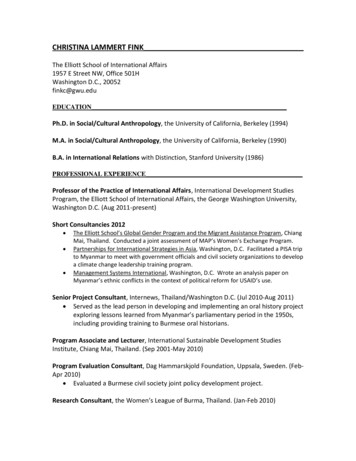
95 1 512613Map 2: Protected Areas of b.org.mmThere is one marine park. Myanmar has no World Heritage Sites (WHS), but several Protected Areashave been put forward to the WHC committee for consideration (See Map 2 for the full list ofProtected Areas)4.CoverageThe current Protected Area network covers considerably less than the Aichi Target of 17% of totalland area (see Box 1) and the global average of 14.8%. Myanmar’s 42 Protected Areas extend over52,946 km2 which represents 8.1% of the total land area of 653,080 km2 (See Annex 1). However, thisis an increase from the less than 1% afforded protection in 1996.The most recent National Biodiversity Strategy and Action Plan (NBSAP, 2015-2020) proposes sevenadditional Protected Areas by 2021.5 A more recent document written by the Ministry of NaturalResources and Environmental Conservation (MONREC) identifies ten (rather than seven) furthersites occupying a further 1.4% of land.6 Over the longer term, Myanmar’s 30-year Forest Master Plan(2002-2031) established a target for Protected Areas to increase to 10%.Expansion of the Protected Area network is desirable. However, unless there is budget andmanagement on the ground, there is a risk that these will be little more than "paper parks", even ifpaper parks have some value.BOX 1 - AICHI BIODIVERSITY TARGET 11 ON PROTECTED AREASAt the tenth meeting of the CBD Conference of the Parties in 2010, in Nagoya, Aichi Prefecture,Japan, 20 Biodiversity Targets were agreed for 2011-2020 period. Target 11 relates toProtected Areas and states that “By 2020, at least 17% of terrestrial and inland water areasand 10% of coastal and marine areas, should be protected”. The areas conserved should be:Source: WCS, Protected Areas, 2017.4 Of particular importance for biodiversity and ecosystem services Ecologically representative – including at least 10% of each ecoregion within the country Effectively and equitably managed – with measures in place to ensure ecological integrityand the protection of species, habitats and ecosystem processes, with the full participationof indigenous and local communities, and such that costs and benefits of the areas arefairly shared. Well-connected – to the wider landscape or seascape using corridors and ecologicalnetworks to allow connectivity, adaptation to climate change, and the application of theecosystem approach.4 Map provided by WCS5 MOECAF (2015). National Biodiversity Strategy and Action Plan (2015-2020) The Republic of the Union of Myanmar,Ministry of Environmental Conservation and Forestry6 Forest Department (2017). Biodiversity Conservation in Myanmar, an overview. The Republic of the Union ofMyanmar, Ministry of Natural Resources and Environmental Conservation5
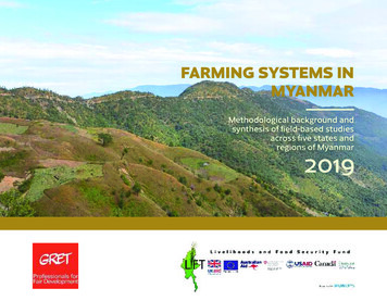
95 1 512613Myanmar's Protected Areas range in size from 0.5 km² (the Lawkananda Wildlife Sanctuary nearBagan) to 22,000 km² (Hukaung Valley Wildlife Sanctuary in the Northern Kachin State). OlderProtected Areas tend to be smaller, whereas the more recent ones aim to protect entire landscapesin order to preserve species with large home ranges such as the Asian elephant and tiger, whorequire large areas of contiguous habitat for long-term survival.RepresentativenessIn terms of representativeness, the network does not achieve the target of having at least 10% ofeach ecoregion represented. Due to the presence of a few large Protected Areas in Kachin andSagaing, a number of ecoregions such as the Eastern Himalayan alpine shrub and meadows (96%in Protected Areas), Northern Triangle temperate and subtropical forests (36% in Protected Areas)are well represented. However, seven ecoregions have less than 1% or no protection (see Annex 1),including 4 ecoregions classified as critically endangered.The lack of Marine Protected Areas (MPA) is a significant gap, with just a single Protected Area inthe country (Lampi Marine National Park). Flora and Fauna International (FFI) has sponsored andco-sponsored a range of studies to expand the knowledge base and facilitate the development of anetwork of Marine Protected Areas in Myanmar, particularly in the Myeik Archipelago (see Map 3)7.These studies add to the understanding of marine ecosystems in the area and provide a platformfor the identification of priority sites for further conservation action. Three Locally Managed MarineAreas (LMMAs) are being set up in the Myeik Archipelago in addition to the Lampi Marine NationalPark. LMMAs tend to be largely or wholly managed at the local level by coastal communities andrepresent a traditional approach to community-based fisheries. It should be noted that LMMAs area fisheries management tool and are not designed to conserve marine biodiversity per se.FinancingMyanmar’s Protected Area network is underfunded. Over the period 2010-2015, an average of 1.9million a year or 43/km2 was spent on Protected Areas.8 Union funds contribute 41% of this figure(an average of 0.79 million a year) and externally-funded projects account for 59% ( 1.1 million).Funding levels differ greatly between sites. A third of Protected Areas and 10% of the total areaunder protection have no budget at all. According to MONREC, in 2014/15 approximately 18.7million of external funding was provided for a range of projects, a significant increase on previousyears. However, it is not clear how much of that was spent on conservation activities and it shouldbe noted that these external funds are not guaranteed annually. MONREC recognises the issue:target 20.1 of the NBSAP states that “by 2020, the funding available for biodiversity from all sourcesis increased by 50%”.Protected Areas generate little or no income (less than 17,000 in 2013/14) and there has previouslybeen no system in place that would allow Protected Area revenues to be retained and reinvestedin the Protected Area network. All earnings are submitted to the central treasury. This may changewith the new Biodiversity and Conservation of Protected Areas Law (2018) which has a provisionfor the Director General (Forest Department, MONREC) to “determine a system for Payment ofEcosystem Service derived from the ecosystems within a Protected Area” but provides no further7 Map provided by FFI Myanmar Programme8 Emerton, L. et al. (2015). Sustainable financing for Protected Areas. Yangon, Wildlife Conservation rb.org.mmdetails on how this will be implemented.9The private sector contributes a small amount to the Protected Area network but could play agreater role in the future. For example, as compensation for biodiversity impacts related to pipelineconstruction, the Tanintharyi Nature Reserve is funded by the Moatama Gas Transportation Company(TOTAL), the Tanintharyi Pipeline Company (Petronas) and PTT Exploration and Production. This isdiscussed in more detail in the main report. The Htoo Group of Companies (HGC) has a managementcontract with the Forest Department to run Hlawga Park, Pyin Oo Lwin Botanical Garden, Nay PyiTaw, Yadanabon and Yangon Zoological Gardens.The Wildlife Conservation Society (WCS) has explored a range of sustainable financing options forProtected Areas, including REDD payments, payments for ecosystem services (PES), compensationfunds, offsets, user fees, voluntary levies and ecotourism. A Myanmar Ecotourism Policy andManagement Strategy for Protected Areas has been produced and an ecotourism plan formulatedfor Lampi Marine National Park.10Governance and EnforcementMany Protected Areas lack staff, management plans and basic infrastructure. They consequentlysuffer from threats of encroachment, poaching and over-harvesting of non-timber forest products.There is a strong correlation between the threat status of Protected Areas and the prevalence ofwell-paid and trained staff who have access to resources to adequately patrol Protected Areas11and to develop community projects to minimise existing threats. Simply stated, the better the staffresources, the less threatened the Protected Areas.Without objectives and plans, it is hard to assess management effectiveness. It is difficult to obtainaccurate data on staffing, training, availability or status of management plans, park infrastructureand conservation outcomes. A review of information on existing and proposed Protected Areaswas undertaken in 2011 by Istituto Oikos.12 The report provides information on 43 existing andproposed sites and undertook rapid assessment surveys of 30 sites. The report concluded thatalthough 20 Protected Areas had some kind of planning document, they were not comprehensivemanagement plans. Staff at 70% of the surveyed Protected Areas stated that lack of budget andstaff (both in numbers and quality) were the main constraints to the implementation of managementactions. Patrolling, environmental education and wildlife surveys are implemented in approximatelyhalf of the surveyed Protected Areas. Shifting cultivation and/or permanent agricultural fields werealso present inside a third of the sites they visited, resulting in forest degradation.A quarter of Protected Areas included some form of community based natural resourcesmanagement and community forestry in the areas surrounding the Protected Area, with a slightlyhigher percentage having outreach programs. Conflicts with local communities and armed groupswere identified as the main obstacle to effective management in 15% of the sites visited. It should beemphasised, however, that even so called ‘paper parks’ can be important in conserving biodiversity.9 See the Biodiversity and Conservation of Protected Areas Law (2018). The Republic of the Union of Myanmar,Union Parliament Law No. 1210 MOECAF (2015). Myanmar Ecotourism Policy and Management Strategy for Protected Areas. The Republic of theUnion of Myanmar, Ministry of Environmental Conservation and Forestry.11 Tranquilli, S. et al. (2014) Protected Areas in Tropical Africa: Assessing Threats and Conservation Activities. PLOSOne12 Istituto Oikos and BANCA (2011).Myanmar Protected Areas: Context, Current Status and Challenges. Milano, Italy7
95 1 512613Map 3: Important Biodiversity Areas of the Myeik .mcrb.org.mmThis largely relates to the maintenance of habitats rather than species of conservation concern.MONREC recognises the issue around governance: the NBSAP Target 11.3 requires that “by 2020,the management effectiveness of Myanmar's Protected Area system has significantly improved,with 15 Protected Areas implementing SMART [Spatial Monitoring and Reporting Tool], at least 5Protected Areas implementing management plans, and local communities involved in managementactivities in at least 5 Protected Areas”.Management plans have been developed for one proposed Protected Area (Tanintharyi NatureReserve) and one existing protected Area (Lampi Marine National Park). A further four are beingdeveloped (Indawgyi, Alaungdaw Kathapa, Natmataung and Meinma-hla-kyun) and planning is inplace for seven others (Hkakaborazi, Hukaung, Htamanthi, Chatthin, Popa, Shwesettaw, Moeyingyi).Lampi Marine National Park is managed by MONREC with assistance from Istituto Oikos. Acomprehensive management plan has been completed that outlines a vision and objectivesfor the park together with management activities, zoning, and community outreach to improveconservation and community livelihoods. There is also an accompanying ecotourism plan as thepark does not currently financially benefit from tourism activity within the Park.13 Following a tender,the Natural Conservation and Wildlife Division (NCWD) of MONREC approved the development ofan eco-resort on Wa Ale Island in the Lampi Marine National Park scheduled to open in late 2018.14Social Implications of Protected Area ExpansionAlthough the global and local benefits of biodiversity and ecosystem services are well recognised,some of the costs of Protected Areas have historically been borne by local people. There iswidespread acceptance that conservation policy should, at the very least, do no harm, and wherepossible should contribute to poverty alleviation.15 Tensions between the need to protect highvalue habitats whilst ensuring the rights of local communities are exemplified by local protestsregarding the proposed expansion of Mt. Hkakabo Razi National Park in October 2017. The socialimplications of any new Protected Area should be thoroughly assessed to ensure respect for fullparticipation and customary rights. Threats to existing Protected Areas are likely to continue due todependence by communities on these natural resources - hence the need for clearly defined andwell-managed buffer zones that meet the requirements of surrounding communities.The new Biodiversity and Conservation of Protected Areas Law (2018) does stipulate a greaterrole for local communities. The Law recognises “Community Protected Areas” as a category ofprotected area and requires the Forest Department to provide “technical coordination and supportfor management of Community Protected Areas”. The Law also permits the Director General (ForestDepartment, MONREC) to allow co-management in collaboration with the local communities anddefines buffer zones for the socio-economic development of local communities.16 It is likely thatthe new by-laws (2019) will further clarify management rights for local communities and allow morecommunity involvement.Source: Fauna & Flora International Myanmar Programme (2017).813 Instituto Oikos (2015). Lampi Marine National Park Ecotourism Plan: 2015-201814 See the Lampi Marine National Park (2018), Nature and Wildlife Conservation Division of Myanmar ForestDepartment15 CBD (2008). Protected Areas in Today’s World: Their Values and Benefits for the Welfare of the Planet. Secretariatof the Convention on Biological Diversity, Montreal, Technical Series no. 3616 See the Biodiversity and Conservation of Protected Areas Law (2018). The Republic of the Union of Myanmar,Union Parliament Law No. 129
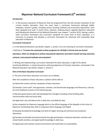
95 1 512613Map 4: Key Biodiversity org.mmMyanmar has a number of conservation initiatives involving local communities, including communitymonitoring of Protected Areas using Spatial Monitoring and Reporting Tool (SMART), which is aconservation tool to allow them to monitor, evaluate and improve the effectiveness of conservationmanagement. There are also community-run forests and locally managed marine areas are inMyanmar.C.Important Designations for Biodiversity Not Yet ProtectedTentative World Heritage SitesMyanmar signed the World Heritage Convention (The Convention for the Protection of the WorldCulture and Natural Heritage) in 1994. World Heritage Sites are officially recognised by the UN ashaving unique cultural, historical, scientific or some other form of significance, and they are legallyprotected by international treaties. States are encouraged to submit a tentative list of sites theyconsider to be of outstanding universal value for inscription on the World Heritage List.Seven sites of importance for biodiversity have been proposed to the World Heritage Committee forconsideration.17 These include: the Ayeyarwady River Corridor, home to the critically endangeredsub-population of freshwater dolphin; the Hukaung Valley Wildlife Sanctuary, one of Asia’s largestintact floodplains; the Indawgyi Lake Wildlife Sanctuary, one of the largest lakes in continentalSoutheast Asia, supporting restricted range freshwater species and large flocks of migrating birds;the Myeik Archipelago; the Nat Ma Taung National Park with a diversity of Himalayan flora includinga rich variety of orchids; the Northern Mountain Forest Complex (Hkakabo Razi and Hponkan RaziNational Parks) covering intact forests spanning nearly 5,000 metres of elevation gain; and theTanintharyi Forest Corridor, one of the largest remaining lowland evergreen forests in SoutheastAsia. Out of these, Nat Ma Taung National Park, Indawgyi Lake Wildlife Sanctuary and HakaboraziNational Park were evaluated for their suitability for the UNESCO World Heritage Site Nationaltentative list, but neither Nat Ma Taung nor Indawgyi fulfilled the integrity and management criteria.Key Biodiversity Areas (KBAs)KBA sites are of global significance for biodiversity and are identified using standardized criteria.They represent the most important sites for biodiversity conservation worldwide.18 Myanmar has132 KBAs. In Myanmar, KBAs (see Map 4)19 have no legal standing as an official form of land tenureexcept where they overlap with formally established Protected Areas. Of these 132 KBAs, 35 areexisting Protected Areas and a further six are proposed Protected Areas, but the majority have nolegal status. Nevertheless, KBA designation assists countries in identifying priority areas for futureconservation efforts and protection; and supports development planning by highlighting the valueof areas so that impacts on biodiversity can be avoided. KBAs are also being increasingly beingtargeted as potential areas for offset sites. Currently, KBAs cover 17% of the country.Three-quarters of the KBAs are located in the north and in Tanintharyi Region encompassing theMyeik Archipelago. The first national natural capital assessment for Myanmar showed that thereSource: WCS, Key Biodiversity Areas, 2013.1017 For details see omination18 See IUCN (2016). A Global Standard for the Identification of Key Biodiversity Areas, Version 1.0. First edition.Gland, Switzerland: IUCN19 Map provided by WCS11
95 1 512613is an overlap between KBAs and important ecosystems. This shows that KBAs have value for theecosystem service benefits they provide, in addition to their value for biodiversity conservation.20D.Main Ecosystems/Habitats of b.org.mmTABLE 1: FOREST COVER IN MYANMAR BY VEGETATION TYPEFOREST TYPES% OF FOREST AREASForestsAside from the provisioning ecosystem services they provide, such as non-timber forest products,charcoal, medicines and construction material, forests ecosystems are a carbon sink and alsostabilise soils. By slowing water flow due to increased infiltration, forests help regulate the seasonalflow of water downstream and recharge sources of groundwater, which supports baseflow instreams. People living downstream benefit from increased stream flows during the dry season,thereby improving access to water for drinking, irrigation, freshwater fisheries etc. By impeding theloss of soils, forests help to maintain the functioning of dam and reservoir infrastructure.Forest constitutes the dominant vegetation type in Myanmar (see Table 1).21 The total area of forestis 290,410 km2 - which is 43% of the total land area.22 However only half of this is described as closedforest, whereas the other half is ‘open’ or ‘degraded’. Myanmar ranks in the top three countriesglobally in terms of the amount of forest lost between 2010 and 2015. The total area of forest lostwas 5460 km2, equivalent to a rate of loss of 1.8%/year.23Rainfall and elevation strongly influence the distribution of different vegetation types. Tropicallowland evergreen rain forest occurs largely in the south in Tanintharyi and the southern Bago Yoma.In the east, north and west there is tropical hill evergreen rain forest (often without dipterocarpspecies) and temperate rain forest; semi-evergreen rain forest borders the arid central plainparticularly in southern Bago Yoma. Myanmar has two types of teak forest: wet deciduous forestpresent in Northern Tanintharyi, Bago Yoma, Bhamo and Mogok; and dry deciduous forest whichoccurs in northern Bago Yoma, Chindwin, western Pakokku and the Shwebo Hills. Some coniferousforests occur above 1200m on dry slopes, particularly in Shan and Chin states, whereas oak andrhododendron occur on the wetter slopes. Extensive bracken and bamboo brakes also occur inMyanmar. Mountain grassland is present, particularly on the Shan plateau, Chin Hills, Rakhine Yoma,and the Northeastern slopes. Indaing forest occurs in small patches along dry ridges of Bago Yoma.Along the Rakhine, Ayeyarwady and Tanintharyi coasts, tidal forests occur in river estuaries,lagoons, tidal creeks and along low islands. Such woodlands are characterised by mangrove andother coastal trees. Beach and dune forests also grow above the high tide line, consisting of palms,hibiscus, casuarinas and other tree varieties. Dry forest occurs where rainfall is usually less than400mm a year and support xerophytic types of vegetation such as semi-desert Euphorbia scruband Acacia thorn type scrub forests.Limestone KarstKarst is a special type of landscape that is formed by the dissolution of soluble rocks, such as20 See WWF (2016) Natural Connections: How natural capital supports Myanmar’s people and economy21 Kress, J. et al. (2003). A Checklist of the Trees, Shrubs, Herbs, and Climbers of Myanmar. Smithsonian Institution22 FAO (2015) Myanmar Forest Resource Assessment. Food and Agriculture Organisation, Rome23 FAO (2016) Global Forest Resources Assessment How are the world’s forests changing? Food and AgricultureOrganisation, Rome12Mixed Deciduous Forest38Hill and Temperate Evergreen Forest25Tropical Evergreen Forest16Dry Forest10Deciduous Dipterocarp (Indaing) Forest5Tidal Forest, Beach and Dune Forest, Swamp Forest4Fallow Land2limestone and dolomite. Karst formations are found in a number of regions including TanintharyiRegion, Kayin State, Shan State, and Kachin State.24 The importance of Karst from a biodiversityperspective relates to the fact that some of the species that are found there have very restrictedranges, some confined to a single cave or peak. This is particularly the case for some invertebratessuch as molluscs. Nineteen new species of gecko have recently been found in Karst habitats inMyanmar.25Freshwater Ecosystems, Wetlands & SpeciesMyanmar supports a diverse range of freshwater ecosystems including large river systems and lakesthat are not only important for biodiversity, but also have cultural and economic value. Myanmarhas eight major river catchments: The Ayeyarwady, Chindwin, Thanlwin, Sittaung, Myit Ma Hkaand Bago, several shorter rivers from the Rakhine Yoma and Chin Hills and the Tanintharyi coastalregion.26 In terms of lakes, the most notable are Inle Lake and one of the largest lakes in Asia,Indawgyi Lake.Few ichthyological (fish) surveys have been undertaken in Myanmar, so data is limited. However,a 2017 Strategic Environmental Assessment of the hydropower sector27 includes a lot of valuable24 MOECAF (2015). National Biodiversity Strategy and Action Plan (2015-2020).25 See the Mongabay. Myanmar caves yield up 19 new gecko species. 11-10-201726 IFC (2017) Draft baseline of the Strategic Environmental Assessment (SEA) of the hydropower sector in Myanmar:Baseline Assessment, Chapter 4, Biodiversity.27 IFC (2017). Strategic Environmental Assessment of the Hydro Sector in Myanmar: Baseline Assessment, Chapter13
95 1 512613Map 5: Major Vegetation Types of b.org.mminformation on freshwater ecology. In addition to summarising the aquatic ecology and fisheriesbaseline of the different catchments, the report identifies stretches of river that are particularlysensitive from an ecological perspective using a range of criteria. These include rarity of riverclass, presence of confluences (which are important locations for mixing of biodiversity and formigrations), reaches flowing through karst limestone, presence of restricted range and threatenedspecies and the presence of wetland or Ramsar sites. These are presented in Map 628.One of the more valuable stretches is the Ayeyarwady River Corridor (ARC), which has beenproposed as a World Heritage Site. It stretches from north of Mandalay to Bhamo and supports theCritically Endangered (CR29) freshwater subpopulation of the Irrawaddy Dolphin, other threatenedbirds and turtles such as Northern River Terrapin (CR) and the Burmese Eyed Turtle (VU), and theWhite-bellied Heron (CR) and valuable riparian habitat. The southernmost segment is already theIrrawaddy Dolphin Protected Area (PA). The World Bank is funding the Ayeyarwady IntegratedRiver Basin Management Project, which aims to strengthen the government’s ability to sustainablymanage the Ayeyarwady River by developing water resources management institutions andenabling informed decisions about future investments in developing the river. In the Tanintharyiriver catchment, where until recently few surveys of aquatic biodiversity had been carried out,recent surveys identified 103 species, of which 7 are endemic and 9 potentially new to science andunnamed.Field surveys of bird species found at 8 sites including intertidal mudflats, mangroves, sandybeaches, near coastal forest habitats and rocky islands were undertaken in 2008-2013 alongMyanmar’s coastline.30 This identified 80 species of water birds, including 39 species of waders, 12gulls and terns, 11 duck and geese, and 7 heron and egrets. This included 10 globally threatenedspecies (such as the Spoon-billed Sandpiper (CR) and Nordmann’s Greenshank (EN). Myanmarratified the Ramsar Convention on Wetlands of International Importance in 2005 and, as of 2017,has five Ramsar sites.The Indawgyi Lake Ramsar Site in Kachin State is the largest freshwater lake in Myanmar. It is alsoa proposed World Heritage Site supporting 20,000 migratory and resident water birds. Ten ofthe bird species present are globally threatened and the lake is also home to several restrictedrange fish and turtle species, including the Burmese Peacock Turtle. The Moyingyi Wetland WildlifeSanctuary and the Meinmahla Kyun Wildlife Sanctuary in the Ayeyarwady Delta are both Ramsarsites.31The former provides habitat for 20,000 migratory water birds, including the globally threatenedSource: Kress, J. et.al (2013) A Checklist of the Trees, Shrubs, Herbs, and Climbe
5 A more recent document written by the Ministry of Natural Resources and Environmental Conservation (MONREC) identifies ten (rather than seven) further sites occupying a further 1.4% of land. 6 Over the longer term, Myanmar's 30-year Forest Master Plan (2002-2031) established a target for Protected Areas to increase to 10%.