Transcription
NORTH EAST STUDENTS GEO-CONGRESS ON ADVANCES IN GEOTECHNICAL ENGINEERING-2014(NES –Geocongress 2014)18th October 2014, IIT-GuwahatiDevelopment of an Android Application for Geotechnical EngineersMan Parvesh Singh Randhawa1, A. Murali Krishna2Under Graduate student, m.randhawa@iitg.ernet.in1, IIT GuwahatiAssociate Professor, amurali@iitg.ernet.in2, IIT GuwahatiABSTRACT:With the advancement in technology, many people believe that there must be some involvement of latesttechnology like the Android platform in our day-to-day practices. Many engineering applications are beingdeveloped using this platform. This paper presents the development of Android Application for soilclassification system. A simple Android application, that uses input experimental values like percentagepassing through different sieves (sieve no. 4, 10, 40 and 200), D10 , D30, D60, Liquid Limit and Plastic limit,has been developed.Keywords: Android, Geotechnical Engineering, Soil Classification1. INTRODUCTIONClassification is fundamentally important to any science. Not only is it a means to impose order on diversitybetween and within objects and concepts, but classification also provides the avenue through whichresearch can be addressed in a rigorously systematic manner. Classifications also have more practicalapplications. Classification of soils, for instance, is indispensible to the soil survey program of mapping thesoils of various regions of the world. Soil surveys, in turn, can be used to apply the principle functions ofsoil science to agriculture, forestry and engineering to predict soil behavior under defined use andmanagement or manipulation. Engineers, typically geotechnical engineers, classify soils according to theirengineering properties as they relate to use for foundation support or building material. Modern engineeringclassification systems are designed to allow an easy transition from field observations to basic predictionsof soil engineering properties and behaviors.There are various soil classification systems used now a days, like USCS (Unified Soils ClassificationSystem), AASHTO (American Association of State Highway and Transportation Officials), ISSCS (IndianStandard Soil Classification System), etc.There are already some applications based on Android and other platforms. Some of them are listed below:1. Geotechnical Daily Field Report (GFR)[1]: It is an Android app designed for geotechnical engineersand geotechnical engineering technicians to generate daily field reports in the field.2. Geo Lab Tool Demo[2]: An essential tool for cartography, geotechnical, slope stability,geodynamics, and more.3. Bearing Capacity FREE[3]: The application gives a preliminary value of the ultimate and designbearing resistance of the spread foundations with different shapes: rectangular, square, circular andstrip footings.4. Portable Geotechnics–Using Android smart phones and tablets for Geotechnical fieldinvestigations[4]: With available applications for various Android devices it is possible to use manyapplications for: geotechnical/geological mapping in real time, collecting strike-dip measurements,borehole logging, augmented photo visualization of investigation site, data storage and geotechnicalanalysis (such as RMR calculation, soil bearing capacity etc.).1
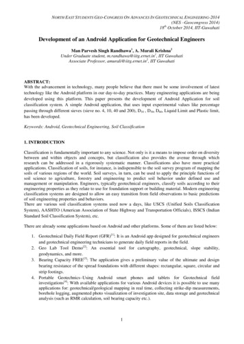
NES-Geocongress 20142In this paper, we present a simple Android application that classifies soil samples on the basis of theirpercentage sieve passing values according to various Soil Classification Systems.2. ABOUT THE CLASSIFICATION SYSTEMS2.1. USCS: The Unified Soil Classification System (USCS) is a soil classification system usedin engineering and geology to describe the texture and grain size of a soil. The classification system can beapplied to most unconsolidated materials, and is represented by a two-letter symbol. The flow-chart relatedto this classification system, according to ASTM D 2487-06[5], used in our application is given in Fig. 1.2.2. ISSCS: In the Indian Standard Soil Classification System (ISSCS), soils are classified into groupsaccording to size, and the groups are further divided into coarse, medium and fine sub-groups. The flowchart related to this classification system, according to IS 1498[6] used in our application is given in Fig. 2.2.3. AASHTO: The AASHTO Soil Classification System was developed by the American Association ofState Highway and Transportation Officials, and is used as a guide for the classification of soils and soilaggregate mixtures for highway construction purposes. The classification system was first developed byHogentogler and Terzaghi in 1929, but has been revised several times since. The flow-chart related to thisclassification system, according to AASHTO M-145-91[7] used in our application is given in Fig. 3.3. DESIGN OF THE APPLICATION: This project was made in a Java Integrated DevelopmentEnvironment named Eclipse that contains a base workspace and an extensible plug-in system forcustomizing the environment. Eclipse is used for development of various applications with the help ofvarious plug-ins that are helpful in writing in other programming languages too, like C, C , Fortran,JavaScript, etc. Android Development Tools is a plug-in for Eclipse that is designed to provide anintegrated environment which is used to build Android applications. ADT extends the capabilities ofEclipse to let developers set up new Android projects, create an application UI (User Interface), addpackages based on the Android Framework API, debug their applications using the Android SDK tools, andexport signed (or unsigned) *.apk files in order to distribute their applications. It also provides an option tocreate Android Virtual Devices (AVDs) on a PC. These virtual devices can be used to test Android appsdeveloped in the software and their specifications can be defined by the user.An android application basically consists of several 'activities' that are loosely bound to each other.Activities are the components of an application that provide a screen with which users can interact in orderto do something, such as dialing the phone, taking a photo, etc.Firstly, a basic design was prepared using XML (Extensible Markup Language).The internal processing code was written in Java using relevant algorithms shown in figures 1,2, and 3.3.1. How various screens and their components look like:3.1.1. The main screen that allows the user to choose the classification system is shown in Fig. 4.3.1.2. USCS :The input parameters taken for this classification systems, as shown in Fig. 5, were:i. Percentage passing from sieve no. 10ii. Percentage passing from sieve no. 200iii. Liquid Limitiv. D10v. D30vi. D60
3NES-Geocongress 2014Fig. 1. Flowchart for USCS[5]
4NES-Geocongress 2014Fig 2. Flowchart for ISSCS classification system[6]
5NES-Geocongress 2014Fig. 3. Flowchart for AASHTO soil classification system[7]Fig. 4. Main ScreenFig 6. ISSCSFig. 5. USCSFig 7. AASHTO
NES-Geocongress 20143.1.3. ISSCS:The input parameters taken for this classification systems, as shown in Fig. 6, were:i. Percentage passing from sieve no. 4ii. Percentage passing from sieve no. 200iii. liquid limitiv. plastic limitv. D10vi. D30vii. D603.1.4. AASHTO:The input parameters taken for this classification systems, as shown in Fig. 7, were:i. Percentage passing from sieve no. 10ii. Percentage passing from sieve no. 40iii. sieve no. 200iv. liquid limitv. plastic limit3.2. Examples to demonstrate the working:3.2.1. USCS: Taking sample values of the following, results are given in Fig. 8:a) Percentage passing from sieve no. 10 34b) Percentage passing from sieve no. 200 23c) Liquid Limit 34d) D10 23e) D30 43f) D60 56Fig. 8. Results in USCSFig. 9. Results in ISSCS3.2.2. ISSCS: Taking sample values of the following, results are given in Fig. 9:a) Percentage passing from sieve no. 4 34b) Percentage passing from sieve no. 200 23c) Liquid Limit 54d) Plastic Limit 22e) D10 22f) D30 336
7NES-Geocongress 2014g) D60 553.2.3. AASHTO: Taking sample values of the following, results are given in Fig. 10:a) Percentage passing from sieve no. 10 56b) Percentage passing from sieve no. 40 22c) Percentage passing from sieve no. 200 23d) Liquid Limit 34e) Plastic Limit 3Fig 10. Results using AASHTO4. CONCLUSIONThis topic needs to be worked upon, as it will be helpful to most of the geotechnical engineers. There areseveral tasks that can be accomplished using the technology of Android to decrease the load of ourengineers. Many more functions of Android operating system can be utilized for the same purpose.5. REFERENCES[1] ECM Geotechnical (2012), Version 1.00.http://webs.lanset.com/ecmgeotechnical/[2] Rafael de Amos Espinosa (2013), Version 2.0https://play.google.com/store/apps/details?id com.rafa.geolabtooldemo[3] Terrasolum (2013), Version 1.1.1https://play.google.com/store/apps/details?id es.terrasolum.bearing free[4] U. Djuric , B. Abolmasov, P. Dragana, M. Marjanovic, P.Kuzmic, (2013) Portable Geotechnics – usingAndroid smart phones and tablets for Geotechnical field investigations, 13th SGEM GeoConference onInformatics, Geoinformatics And Remote Sensing, Vol 1, 4[6] American Society for Testing and Materials (2006), ASTM D 2487-06.[5] Indian Standards (1970), IS 1498, pp.14-23[7] American Association of State Highway and Transportation Officials (2008), AASHTO M-145-91.
classification system, according to AASHTO M-145-91[7] used in our application is given in Fig. 3. 3. DESIGN OF THE APPLICATION: This project was made in a Java Integrated Development Environment named Eclipse that contains a base workspace and an extensible plug-in system for customizing the environment. Eclipse is used for development of various applications with the help of various plug-ins .