Transcription
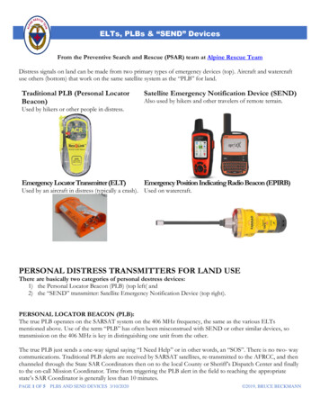
ELTs, PLBs & “SEND” DevicesFrom the Preventive Search and Rescue (PSAR) team at Alpine Rescue TeamDistress signals on land can be made from two primary types of emergency devices (top). Aircraft and watercraftuse others (bottom) that work on the same satellite system as the “PLB” for land.Traditional PLB (Personal LocatorBeacon)Satellite Emergency Notification Device (SEND)Also used by hikers and other travelers of remote terrain.Used by hikers or other people in distress.Emergency Locator Transmitter (ELT)Emergency Position Indicating Radio Beacon (EPIRB)Used by an aircraft in distress (typically a crash). Used on watercraft.PERSONAL DISTRESS TRANSMITTERS FOR LAND USEThere are basically two categories of personal destress devices:1) the Personal Locator Beacon (PLB) (top left( and2) the “SEND” transmitter: Satellite Emergency Notification Device (top right).PERSONAL LOCATOR BEACON (PLB):The true PLB operates on the SARSAT system on the 406 MHz frequency, the same as the various ELTsmentioned above. Use of the term “PLB” has often been misconstrued with SEND or other similar devices, sotransmission on the 406 MHz is key in distinguishing one unit from the other.The true PLB just sends a one-way signal saying “I Need Help” or in other words, an “SOS”. There is no two- waycommunications. Traditional PLB alerts are received by SARSAT satellites, re-transmitted to the AFRCC, and thenchanneled through the State SAR Coordinators then on to the local County or Sheriff’s Dispatch Center and finallyto the on-call Mission Coordinator. Time from triggering the PLB alert in the field to reaching the appropriatestate’s SAR Coordinator is generally less than 10 minutes.PAGE 1 OF 5 PLBS AND SEND DEVICES 3/10/2020 2019, BRUCE BECKMANN
ELTs, PLBs & “SEND” DevicesHow the PLB (and ELT, EPIRB) notification system worksThe Air Force Rescue Coordination Center (AFRCC) is responsible for coordinating search and rescue activities inthe 48 contiguous United States and will support search and rescue operations for American citizens in Mexico andCanada. The Civil Air patrol (CAP), along with the U.S. Coast Guard- when needed, law enforcement, and otherfirst responders will be engaged in the actual search for downed aircraft. Today, ELTs have evolved from just atransmitter of a signal that is used to locate a downed craft, to emergency position-indicating radio floatingbeacons for watercraft (EPIRBs) and now GPIRBs (GPS transmitting emergency position-indicating radiobeacons).All ELTs and EPIRBS transmit on the 406 MHz frequency. This signal is received by the Search and RescueSatellite Aided Tracking system (SARSAT), which is in inter-governmental co-op of 45 nations dedicated todetecting such emergency signals. Today’s EPIRBS and GPIRBS also transmit a homing beacon on the 121.5 MHzthat can be picked up by ground radio detection devices, but the area of reception is very limited to about ½ mile.Once a signal is detected on SARSAT, in less than one minute, it is transferred to one of 30 Mission ControlCenters (MCC) around the world. The US based MCC is located in Suitland, Maryland, and is managed by NOAA(National Oceanic and Atmospheric Administration).The location of the signal is then transferred to the AFRCC at Langley Air Force Base in Virginia. Then, AFRCCnotifies the appropriate state’s SAR entity — in Colorado, the Colorado SAR Association — and then the localSheriff’s Office, who in turn, activates the local SAR team(s). There is a high incidence of false alarms with aircraftELT type transmitters. According to NOAA’sSARSAT tracking team, in 2017, 98% of the nearly 8,900 alerts were false activations, with only 112 being realemergencies. ELTs typically transmit for a minimum of 48 hours.In 2019, a popular PLB is made by ACR Electronics and sells for about 300. It has nosubscription fees, and there are a variety of models to choose from. When new, battery lifeis guaranteed for 5 years, after which the battery should be replaced by an authorized repaircenter for about 100. Monthly tests of satellite connectivity are recommended. If the PLBis used in an emergency, ACR will replace the battery at no charge.PLBs MUST be registered with NOAA. This can be done on-line viahttps://www.sarsat.noaa.gov/beacon.html.The PLB transmits an emergency signal on the 406 MHz to the satellites and includes a GPScoordinate in the transmission, making the determination of the subject’s location moreaccurate, even to within about 100 meters, provided the PLB can obtain an accurate “fix” on the satellites. TruePLBs typically also transmit a homing beacon signal on the 121.5 MHz frequency for a minimum of 24 hours,SEND units do not.PLBs on the 406 MHz frequency enjoy better satellite communications due to having a 5 watt transmitter (e.g., ableto push through dense overhead foliage) vs a 1.6 watt transmitter on a SEND device, as discussed below. PLBs arenot dependent on cellular networks and generally work around the world. However, if traveling to a foreigncountry, contact that country or NOAA to learn about any usage restrictions in foreign countries.PAGE 2 OF 5 PLBS AND SEND DEVICES 3/10/2020 2019, BRUCE BECKMANN
ELTs, PLBs & “SEND” DevicesPLBs do not allow the user to describe the nature of the emergency, it is just an “SOS” type broadcast. Locationaccuracy relies on the US government’s GPS satellite system and requires a clear view of the sky. Having said that,GPS signals may still be affected due to shielding by terrain, atmospheric conditions or other factors occurringbetween the earthbound transmitter and the SARSAT satellites travelling 22,000 miles above earth.Older PLB’s, if still in operation, without the GPS coordinate capability, provide a large footprint of a potentialsearch area that can be several square miles in size.SATELLITE EMERGENCY NOTIFICATION DEVICE (SEND)As of 2019, SEND devices can be either one-way transmission devices, such as thebasic SPOT, or two-way satellite transmission units such as the Spot X or Garmin inReach units.Today, there are a variety of manufactures and many models to choose from. The keydifference between SEND and PLB devices is the frequency the units operate on.SEND units transmit on the 1610 to 1626 MHz frequency range, versus the truePLB on the 406 MHz frequency. The other big difference is in signal strength. TheSEND units are 1.6 watts of transmit power and the PLBs are 5 watts.SEND devices utilize a network of commercial satellites versus governmental satellites and provide for twoway communications. These units communicate directly to the commercial satellite and are not dependent oncellular networks. SEND transmitters generally work around the world, if traveling to a foreign country, contactthat country or NOAA to learn about any usage restrictions.There are many commercial satellite constellations for backcountry emergency communication and the mostpopular are the Iridium and the Globalstar satellite constellations, as opposed to the governmentally operatedSARSAT satellite system. Garmin in-Reach uses the Iridium satellite constellation is owned by Iridium Communications, Inc. andconsists of 66 active satellites. The Iridium system operates in the frequency range of 1616 to 1626.5 MHz.SPOT uses the Globalstar satellite system is owned by Globalstar Inc. which consists of 24 active satellites.The Globalstar system operates in the frequency range of 1610.73 to 1621.35 MHz. Globalstar is used bythe OnStar System in some vehicles. This system, and uses one frequency for US units and a differentfrequency for the rest of the world.Both satellite systems operate in a low earth orbit of 485 miles versus the SARSAT’s 22,000 mile orbit.GEOS International Emergency Response Coordination Center (GEOS-IERCC), located in Houston TX,monitors both the Iridium and Globalstar satellites for emergency traffic. If an emergency signal is detected, GEOSdetermines the location and alerts the appropriate county’s Sheriff who then activates local SAR teams for that area.Some folks carry both a true PLB (406 MHz) and a two-way satellite transceiver such as a Spot X or Garmin inReach ( 1610 – 1626 MHz range). Each has their unique advantages.PAGE 3 OF 5 PLBS AND SEND DEVICES 3/10/2020 2019, BRUCE BECKMANN
ELTs, PLBs & “SEND” DevicesFor example: PLBs (406 MHz with 5 watts output power) will push an SOS signal through dense foliage better than aSEND. Getting the signal out under adverse conditions may lead to a faster reporting time to local SARteams than the two-way satellite communication units. And, it is only a one-way communication.Whereas the SEND devices ( 1610 – 1626 MHz range and only 1.6 watts of power) may struggle to reachthe satellite in similar conditions; but, it does allow for 2-way conversations when connected.TWO-WAY SATELLITE COMMUNICATIONSAs of 2019, there are several companies who now offer global satellite two-way communications. SPOT X andGarmin in-Reach are probably the most widely used in the back country here in the US. Many features are similar,and each has its unique features. This is not an endorsement of either type. If interested in purchasing a SEND unit,you must research each unit’s features, costs, ongoing subscriptions, etc. and determine which unit best meets yourspecific needs, and price range.In 2019, the purchase price of a SEND unit varies, most in the 250 to 450 range depending on available features.Too, there are a variety of available service plans, which must be purchased foroperation of the unit. Some service plans are annual, others are monthly. In comparison, a true PLB does NOTrequire the purchase of any service plan.Because SEND units operate on private networks, registration with NOAA is not required. But, registration withthe company is required for activation. Each company may request varying amounts of info, some is optional.Registration includes general information that might be needed in a rescue, e.g., name, age, address, medical info ifdesired, secondary emergency contact info, etc. It is from such registration that this important emergencyinformation is provided to GEOS for use in an actual emergency.GENERAL FEATURES FOUND ON SEND UNITSThe Garmin in-Reach and SPOT X are examples of modern global – two-way communication devices. Today, thereis a wide selection of vendors. Features found in these units vary, but now most allow the user to:1. Send an SOS – along with the GPS coordinates, and elevation of the individual requesting help. Thismessage is without detail- just “I Need Help”;2. Send pre-written text messages to a selected recipient or recipients, and most importantly,3. Send and receive customized SMS text messages (like on a smart phone) to any selected recipient orrecipients. This feature allows the user to explain the nature of the emergency, and provide details ofthe emergency versus just “I Need Help”.Messages can often be directed to any cell phone number and/or to an email address. Too, units may allow directposting to social media accounts like Facebook and Twitter.A smart cell phone may be linked via Bluetooth to make “texting” easier. This feature may vary based on the unit.Some units on the market, such as Bivystick, require the linking of a cell phone for full operation. So, if the cellphone is broke or the battery is dead, you cannot communicate.PAGE 4 OF 5 PLBS AND SEND DEVICES 3/10/2020 2019, BRUCE BECKMANN
ELTs, PLBs & “SEND” DevicesThe SEND units function independent of a cell phone network; thus “no signal, no problem”.Basic mapping (scales vary) and other limited features found on a standard handheld GPS unit may also beprovided. Again, features vary based on model, etc.Furthermore, the Garmin in-Reach and Spot X user may allow for his/her location to be “shared”. Sharing allows aperson or persons at home to track that individual real time in the field on a mapping system. These programs varyfrom proprietary mapping programs to the use of Google maps, and can be used on an individual’s computer, smartphone, or similar device; cellular or internet connection is required for the “in town” person to view such activityon-line. Periodic track points show current coordinates of each point, a visual tracking of the route a person istaking, the direction headed, elevation, and calculates speed of travel. Interval of transmission is a user selectedoption and there is a wide range of time intervals available; the most frequently selected interval is every 10 minutes.There are too many companies, with varying features and subscriptions, who now provide these valuable services todiscuss here. If looking to purchase such a device, you should do your own research and determine which servicemeets your unique needs and financial limits.Alpine Rescue Team of Evergreen, Colorado is a mountain search and rescue unit dedicated to saving lives through search, rescue,and mountain safety education. The Team is composed totally of volunteers and is available upon request to help in mountain search andrescue problems anywhere, under the authority of local jurisdiction agencies.Alpine Rescue Team has been a nationally-accredited member unit of the Mountain Rescue Association (MRA) since 1962. Thefunction of the national association is to provide coordination, education and standardization to member units to promote maximumsafety and effectiveness in mountain search and rescue. The association provides member units with information on testing and research ofrescue equipment and techniques. It also provides extensive compilation, study and statistical analyses of lost persons and mountainsearch operations from units throughout the country.The team is also an active member of two general rescue organizations. The Colorado Search and Rescue Board (CSRB), is anorganization composed of many rescue units of differing disciplines throughout the state. The National Association for Search and Rescue(NASAR) is an organization which serves as a forum within which search and rescue teams exchange ideas on a national level. Anyteam or group involved with search and rescue, emergency situations, medical disasters, etc. can be a member of NASAR.We have extensive backcountry safety information for hikers, climbers,mountaineers and visitors to the mountains on our PSAR page.PAGE 5 OF 5 PLBS AND SEND DEVICES 3/10/2020 2019, BRUCE BECKMANN
popular are the Iridium and the Globalstar satellite constellations, as opposed to the governmentally operated SARSAT satellite system. Garmin in-Reach uses the Iridium satellite constellation is owned by Iridium Communications, Inc. and consists of 66 active satellites. The Iridium system operates in the frequency range of 1616 to 1626.5 MHz.