Transcription
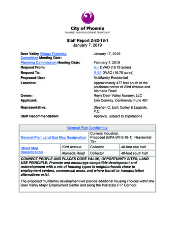
Staff Report Z-82-18-1January 7, 2019Deer Valley Village PlanningCommittee Meeting Date:Planning Commission Hearing Date:Request From:January 17, 2019Request To:Proposed Use:R-3A DVAO (16.78 acres)Multifamily ResidentialLocation:Approximately 477 feet south of thesoutheast corner of 23rd Avenue andAlameda RoadRoy's Deer Valley Nursery, LLCErin Conway, Continental Fund 481Owner:Applicant:February 7, 2019A-1 DVAO (16.78 acres)Stephen C. Earl; Curley & Lagarde,P.C.Approval, subject to stipulationsRepresentative:Staff Recommendation:General Plan ConformityGeneral Plan Land Use Map DesignationStreet MapClassificationCurrent: Industrial,Proposed (GPA-DV-2-18-1): Residential15 23rd AvenueCollector40-foot east halfAlameda RoadCollector40-foot south halfCONNECT PEOPLE AND PLACES CORE VALUE; OPPORTUNITY SITES; LANDUSE PRINCIPLE: Promote and encourage compatible development andredevelopment with a mix of housing types in neighborhoods close toemployment centers, commercial areas, and where transit or transportationalternatives exist.The proposed multifamily development will provide additional housing choices within theDeer Valley Major Employment Center and along the Interstate I-17 Corridor.
Staff Report: Z-82-18-1January 7, 2019Page 2 of 12CELEBRATE OUR DIVERSE COMMUNITIES & NEIGHBORHOODS; CLEANNEIGHBORHOODS DESIGN: Protect and enhance the character of eachneighborhood and its various housing lifestyles through new development that iscompatible in scale, design, and appearance.As stipulated, the proposed project is compatible with existing development and landuses in the immediate area.CELEBRATE OUR DIVERSE COMMUNITIES AND NEIGHBORHOODS COREVALUE; DIVERSE NEIGHBORHOODS; LAND USE PRINCIPLE: Within eachvillage, designate residential land use in at least four of the seven residentialcategories and designate at least one of those categories to be for 10 to 15 or 15 dwelling units per acre.The companion General Plan Amendment request, GPA-DV-2-18-1, proposes theresidential land use map designation of 15 dwelling units per acre which will serve toprovide housing options for those working in the vicinity.Applicable Plans, Overlays, and InitiativesDeer Valley Airport Overlay District – see No. 4, Background/Issues/AnalysisDeer Valley Major Employment Center – See No. 5, Background/Issues/AnalysisTree and Shade Master Plan – see No. 6, Background/Issues/AnalysisComplete Streets Guiding Principles – see No. 7, Background/Issues/AnalysisReimagine Phoenix – see No. 16, Background/Issues/AnalysisSurrounding Land Uses/ZoningOn siteNorthSouthEastWest (across 23rdAvenue)Land UseZoningVacant lotMultifamilyManufacturing facilities,warehouse, officePlant nursery and industrialwarehousing, officeA-1A-1 with use permitVacant lotCP/GCPA-1A-1
Staff Report: Z-82-18-1January 7, 2019Page 3 of 12R-3A Multifamily(Planned ResidentialDevelopment Option)StandardsRequirementsProvisions on theProposed Site PlanTotal Number of UnitsDwelling Unit density(units/gross acre), Maximum387; 443 with bonus23.1; 26.4 with bonus284 units proposed (Met)16.92 (Met)Lot Coverage, Maximum45%37% (Not Met)Maximum Building Height in3 stories or 40 feet for150 feet; 1foot in 5-footincrease to 48 feet, 4story maximum2 stories, 35 feet (Met)10 feet minimumN/A20 feet minimumadjacent to a publicstreet; this area to be incommon ownershipunless lots front on theperimeter public street.15 feet minimum20 feet on Alameda (Met)25 feet on the 23rd AveFrontage (Met)20 feet minimum20 feet (Met)Adjacent to property line5 feet minimum15 feet (Met)Common Area, Minimum5% of gross areaminimum. Stipulated to15% (see Stipulation No.3)1.3 space per efficiencyunit and 1.5 spaces per 1and 2-bedroom unit and2 spaces per 3 or morebedroom unit, 1.0 spaceper unit of less than 600square feet regardless ofnumber of bedrooms5% (Met)Building SetbacksFrontPerimeter StandardsAdjacent to Public StreetAdjacent to property lineLandscape SetbacksAdjacent to Public StreetParking Requirements,Maximum430 spaces required15 feet (Met)516 spaces provided (Met)
Staff Report: Z-82-18-1January 7, 2019Page 4 of 12Background/Issues/AnalysisREQUEST1.This request is to rezone16.78 acres locatedapproximately 477 feetsouth of the southeastcorner of 23rd Avenue andAlameda Road from A-1DVAO (Light Industrial,Deer Valley Airport OverlayDistrict) to R-3A DVAO(Multifamily Residence,Deer Valley Airport OverlayDistrict) to allow multifamilyresidential.Source: City of Phoenix Planning and Development DepartmentZONING AND LAND USE2.The subject site is currently zoned A-1 DVAO (Light Industrial, Deer ValleyAirport Overlay District). There is existing warehousing, office and industrialmanufacturing facilities south of the subject site. There is a multifamily residentialdevelopment north of the subject site zoned A-1 DVAO, with a use permit, CaseNo. ZA-166-04, to allow residential in the A-1 District. Multifamily apartments arelocated to the northwest of the site and vacant parcels are located to theimmediate west and southwest of the site. To the east of the site is a plantnursery, however, a recent application was submitted (Pre-Application No. 18162) requesting multifamily residential zoning for the site as well. The characterof the area is changing from industrial to residential in the northwest quadrant ofthe DVAO Area 1. City Council recently approved rezoning cases, Z-54-15, arequest for multifamily residential at the northwest corner of 23rd Avenue andPinnacle Peak Road and Z-48-16, a request for an assisted living center at thenorthwest corner of 19th Avenue and Alameda Road establishing a change inthe land use pattern in the immediate vicinity.
Staff Report: Z-82-18-1January 7, 2019Page 5 of 12Source: City of Phoenix Planning and Development DepartmentGENERAL PLAN3. The current General Plan LandUse Map designation for thesubject site is Industrial. A GeneralPlan Amendment Case GPA-DV2-18-1 is being processedconcurrently as a companion caseto amend the General Plan LandUse map designation toResidential 15 dwelling units peracre. Staff has recommendedapproval of the General PlanAmendment request.Most of the area designated asindustrial, southeast and south ofthe subject site has developed asindustrial. The area has developedSource: City of Phoenix Planning and Development Department
Staff Report: Z-82-18-1January 7, 2019Page 6 of 12with mostly commerce park;warehouse or office type uses andmore recently with multifamilyresidences. Mixed use with aresidential component is to thewest of the site.Deer Valley Airport Overlay District4.The site is located within the boundaries of the Deer Valley Airport OverlayDistrict (DVAO). This district is intended to protect the health, safety and welfareof persons and property in the vicinity of the Deer Valley Airport (DVA) and toprotect the long term viability of DVA as a general aviation facility by ensuringland use compatibility with airport operations, protecting navigable airspace fromphysical encroachment and requiring permanent notice of flight operations toproperty owners. The DVAO District is divided into three separate regulationszones. The subject site is located within Area 1. Residential uses arediscouraged in Area 1, however, because of recent approvals for residentialdevelopments, the character of this area is evolving. The additional multifamilyhousing options will serve to provide housing options for those working in thevicinity.5.The subject site is located along the Interstate freeway, within the Deer ValleyMajor Employment Center. The proposal adds to housing options within theemployment center.
Staff Report: Z-82-18-1January 7, 2019Page 7 of 12TREE AND SHADE MASTER PLAN6.The Tree and Shade Master Plan has a goal of treating the urban forest asinfrastructure to ensure that trees are an integral part of the city’s planning anddevelopment process. In addition, a vision in the master plan is to raiseawareness by leading by example. To accomplish the vision and goal of thepolicy document, staff is recommending a stipulation for increased landscapesetbacks along the south property line. Trees within the landscape setback areawill help to reduce the urban heat island effect and will provide thermal comfortfor residents and guests going to and from their vehicles. This is addressed inStipulation No. 4.COMPLETE STREETS GUIDING PRINCIPLES7.In 2014, the City of Phoenix City Council adopted the Complete Streets GuidingPrinciples. The principles are intended to promote improvements that provide anaccessible, safe, connected transportation system to include all modes, such asbicycles, pedestrians, transit, and vehicles. To support these principles related topedestrian connectivity and safety, staff has added stipulations to require that thedeveloper construct a detached sidewalk, with the addition of landscapingbetween the sidewalk and the street, on the northern and western portions of thesite along Alameda and 23rd Avenue. This is addressed in Stipulation No. 7.ANALYSIS OF PROPOSAL8.The conceptual site plan proposes a 284-unit multifamily development withaccess from both 23rd Avenue and Alameda Road. The development shall belimited to 298 units to ensure the development maintain similar density todevelopments in the area. The 16 acre site would allow 422 units by right if thezoning is approved. Due to the height of similar residential developments in thearea and the close proximity to the Deer Valley Airport staff is recommendingthat the development be limited to a minimum of 35 feet. To ensure similardensity to other development s in the area a staff is recommending a minimum of15 percent of the gross project area shall be retained as open space. This isaddressed in Stipulation Nos. 1, 2 and 3.9.To accommodate use of bicycles as a form of alternative transportation, staff isrecommending that the developer install secured bicycle parking at 0.25 spacesfor each residential unit and a minimum of four inverted U-bicycle racks forguests located near entrances to the buildings. There is an existing designatedMAG Bike Lane along 23rd Avenue. This is addressed in Stipulation No. 5.
Staff Report: Z-82-18-1January 7, 2019Page 8 of 12Source: MAG BikewaysCOMMUNITY INPUT SUMMARY10. At the time this staff report was written, staff had not received anycorrespondence from the public regarding the request.
Staff Report: Z-82-18-1January 7, 2019Page 9 of 12INTERDEPARTMENTAL COMMENTS11.The subject site is in close proximity to the Deer Valley Airport and is in an areawith heavy overflight traffic. The graphic below shows arrival and departureoverflight in a single week (August 2018). The Aviation Department has notedthat they oppose the rezoning request but request the following mitigatingstipulations if approved: The property is in the Public Airport Disclosure area. This area may be subject to overflights of aircraft operating at the Airport.People are often irritated by repeated overflights regardless of the actualsound level at the overflight site. Therefore, the property owner shallrecord documents that disclose the existence, and operationalcharacteristics of Deer Valley Airport to future owners or tenants of theproperty. The developer shall dedicate an easement to the City prior to constructionpermit approval. The development must erect signage within the development’ssales/leasing office. The indoor noise levels shall not exceed a decibel day night-level (DNL) of45 decibels.These are addressed in Stipulations Nos. 9, 10, 12 and 13.Source: City of Phoenix Aviation Department
Staff Report: Z-82-18-1January 7, 2019Page 10 of 1212.The Street Transportation Department has provided comments. Right-of-waytotaling 55 feet shall be dedicated for the east half of 23rd Avenue and that thedeveloper shall construct all streets within and adjacent to the development.These are addressed in Stipulation Nos. 6 and 8.13.The Public Works, Floodplain Management Department has provided comments.It has been determined that this parcel is not in a Special Flood Hazard Area(SFHA), but located in a Shaded Zone X, on panel 1280 L of the Flood InsuranceRate Maps (FIRM) dated January 29, 2015.14.The City of Phoenix Water Services Department has noted the property hasexisting water and sewer mains that can potentially serve the proposeddevelopment however, there is potential need to up size existing water andsewer infrastructure mains so that any remodels or new buildings will be able tomeet domestic and fire code requirements.15.The Fire Department provided comments that no fire code issues are anticipatedwith this case and the site and/or buildings shall comply with the Phoenix FireCode.OTHER16. As part of the Reimagine Phoenix initiative, the City of Phoenix is committed toincreasing the waste diversion rate to 40 percent by 2020 and to better manageits solid waste resources. Section 716 of the Phoenix Zoning Ordinanceestablishes standards to encourage the provision of recycling containers formultifamily, commercial and mixed-use developments meeting certain criteria.The provisions of recycling containers were not addressed in the applicant’ssubmittal.17.In the event archaeological materials are encountered during construction, thedeveloper shall immediately cease all ground disturbing activities within a 33-footradius of the discovery, notify the City Archaeologist, and allow time for theArchaeology Office to properly assess the materials. This is addressed inStipulation No. 14.18.Development and use of the site is subject to all applicable codes andordinances. Zoning approval does not negate other ordinance requirements.Other formal actions such as, but not limited to, zoning adjustments andabandonments, may be required.Findings1.The proposal does not conform to the current General Plan Land Use Mapdesignation. However, General Plan Amendment (GPA-DV-2-18-1) is being
Staff Report: Z-82-18-1January 7, 2019Page 11 of 12requested concurrently with this rezoning request.2.The proposed rezoning is in conformance with several General Plan goals andpolicies and will serve to provide additional housing choices for those who workin the area.3.The proposed project will develop a vacant lot that is currently underutilizedand as stipulated, the project is compatible with other multifamily projects in thearea.Stipulations1.The maximum building height shall be a maximum of 35 feet.2.The development shall be limited to 298 units.3.A minimum of 15 percent of the gross project area shall be retained as openspace, as approved by the Planning and Development Department.4.A minimum 15-foot landscape setback shall be provided along the southernproperty line, as approved by the Planning and Development Department.5.The developer shall install secured bicycle parking at 0.25 spaces for eachresidential unit and a minimum of four inverted U-bicycle racks forguests located near entrances to the buildings and installed per section1307.H., as approved by the Planning and Development Department.6.Right-of-way totaling 55 feet shall be dedicated for the east half of 23rd Ave, asapproved by the Planning and Development Department.7.All sidewalks along 23rd Avenue and Alameda Road shall be detached with aminimum 5-foot wide landscaped strip located between the sidewalk and backof curb, and shall include minimum 3-inch caliper drought tolerant shade treesplanted a minimum of 20 feet on center or equivalent groupings along bothsides of the sidewalk, as approved by the Planning and DevelopmentDepartment.8.The developer shall construct all streets within and adjacent to thedevelopment with paving, curb, gutter, sidewalk, curb ramps, streetlights,median islands, landscaping and other incidentals as per plans approved bythe Planning and Development Department. All improvements shall complywith all ADA accessibility standards.9.The subject site is within DVAO “Area 1”, development must provide Avigation
Staff Report: Z-82-18-1January 7, 2019Page 12 of 12Notice consistent with DVAO part 658.D.10.Development must provide an avigation easement to the City prior toconstruction permit approval.11.Development must file FAA Form 7460 and provide City FAA’s no hazarddetermination prior to construction permit approval.12.Prior to occupancy, development must erect signage within the development’ssales/leasing office (or equivalent signage) that is visible to prospective rentersor purchases and which discloses the proximity of Deer Valley Airport andincreased frequency of overflight and related aircraft noise, as approved by theAviation Department.13.Prior to occupancy, development must provide City a qualified engineer’sreport certifying the average annual interior noise exposure for any residentialunit or enclosed public assembly area will not exceed 45 decibels.14.In the event archaeological materials are encountered during construction, thedeveloper shall immediately cease all ground disturbing activities within a 33foot radius of the discovery, notify the City Archaeologist, and allow time for theArchaeology Office to properly assess the materials.WriterDavid SimmonsJanuary 7, 2019Team LeaderSamantha KeatingExhibitsSketch MapAerialSite Plan date stamped November 13, 2018 (2 pages)Elevations Date Stamped November 13, 2018 (3 pages)
A-1*Z-11-94C-2 *ANX 125CP/BP *CP/BPZ-SP-1-17A-1 *CP/BP *Z-8-97N 20TH DRCP/GCP *W PARK VIEW LNA-1COUNTYZ-48-16Deer ValleyAirport OverlayDistrict (DVAO)TE CENTER DRS-1*ANX 254Z-43-02CLPNI1 7@Z-39-06W SARAH BASS PLPEAKR-2 *ONBZ-54-15MPNRS-1SP *W PINNACLE P EA K RDRANX 254Z-43-02Z-86-87RE-43A-1 *C-2 HGT/WVR *Z-22-06CZ-195-81IZ-82-18HAPPY VALLEY RDPINNACLE PEAK RD6DEER VALLEY VILLAGEDEER VALLEY DRSR 101CITY COUNCIL DISTRICT: 1APPLICATION NO.Z-82-18MULTIPLES PERMITTEDFROM:16TH ST19TH AVEA-1 DVAO ( 16.78 a.c.)REVISION DATES:GROSS AREA INCLUDING 1/2 STREETAND ALLEY DEDICATION IS APPROX.16.78 AcresREQUESTED CHANGE:11/30/2018DATE:I - 1751ST AVE43RD AVEErin Conway, Continental Fund 481 Fund,7TH AVEBELL RDGREENWAY RD7TH STUNION HILLS DR35TH AVE0APPLICANT'S NAME:C-2JOMAX RDMiles3N20THDN 23RD AVEA-1 M-R6MARICOPAN 19TH AVEZ-39-06S-1Z-61-16ANX 201C-2 *C-2 M-R *P ORAA-1CP/BPW ALAMEDA RDCP/GCP *A-1*ANX 355Z-10-06Z-39-06CORANX 379Z-95-06Z-8-07Z-59-07Z-29-18Z-3-00R-4 *WANX 217Z-11-00Z-8-07ER'S WAYFA RMW CHARLOTTE DRS-1C-2 *Z-101-05S-1Z-92-02C-2 SP*A-1*AERIAL PHOTO &QUARTER SEC. NO.QS 45-24A-1 DVAOR-3A DVAOZONING MAPO-7CONVENTIONAL OPTIONN/A369TO:R-3A DVAO ( 16.78 a.c.)* UNITS P.R.D. OPTION* Maximum Units Allowed with P.R.D. BonusDocument Path: V:\PL GIS\IS Team\Core Functions\Zoning\sketch maps\2018\Z-82-18.mxdN/A443
A-1*Z-11-94C-2 *ANX 125CP/BP *CP/BPZ-SP-1-17A-1 *CP/BP *Z-8-97N 20TH DRCP/GCP *W PARK VIEW LNA-1COUNTYZ-48-16Deer ValleyAirport OverlayDistrict (DVAO)TE CENTER DRS-1*ANX 254Z-43-02CLPNI1 7@Z-39-06W SARAH BASS PLPEAKR-2 *ONBZ-54-15MPNRS-1SP *W PINNACLE P EA K RDRANX 254Z-43-02Z-86-87RE-43A-1 *C-2 HGT/WVR *Z-22-06CZ-195-81IZ-82-18HAPPY VALLEY RDPINNACLE PEAK RD6DEER VALLEY VILLAGEDEER VALLEY DRSR 101CITY COUNCIL DISTRICT: 1APPLICATION NO.Z-82-18MULTIPLES PERMITTEDFROM:16TH ST19TH AVEA-1 DVAO ( 16.78 a.c.)REVISION DATES:GROSS AREA INCLUDING 1/2 STREETAND ALLEY DEDICATION IS APPROX.16.78 AcresREQUESTED CHANGE:11/30/2018DATE:I - 1751ST AVE43RD AVEErin Conway, Continental Fund 481 Fund,7TH AVEBELL RDGREENWAY RD7TH STUNION HILLS DR35TH AVE0APPLICANT'S NAME:C-2Maricopa County Assessor's OfficeJOMAX RDMiles3N20THDN 23RD AVEA-1 M-R6MARICOPAN 19TH AVEZ-39-06S-1Z-61-16ANX 201C-2 *C-2 M-R *P ORAA-1CP/BPW ALAMEDA RDCP/GCP *A-1*ANX 355Z-10-06Z-39-06CORANX 379Z-95-06Z-8-07Z-59-07Z-29-18Z-3-00R-4 *WANX 217Z-11-00Z-8-07ER'S WAYFA RMW CHARLOTTE DRS-1C-2 *Z-101-05S-1Z-92-02C-2 SP*A-1*AERIAL PHOTO &QUARTER SEC. NO.QS 45-24A-1 DVAOR-3A DVAOZONING MAPO-7CONVENTIONAL OPTIONN/A369TO:R-3A DVAO ( 16.78 a.c.)* UNITS P.R.D. OPTION* Maximum Units Allowed with P.R.D. BonusDocument Path: V:\PL GIS\IS Team\Core Functions\Zoning\sketch maps\2018\Z-82-18.mxdN/A443
Deer Valley Major Employment Center and along the Interstate I-17 Corridor. Staff Report: Z-82-18-1 January 7, 2019 . Pinnacle Peak Road and Z-48-16, a request for an assisted living center at the northwest corner of 19th Avenue and Alameda Road establishing a change in the land use pattern in the immediate vicinity. Staff Report: Z-82-18-1