Transcription
Rea, D.K., Basov, I.A., Scholl, D.W., and Allan, J.F. (Eds.), 1995Proceedings of the Ocean Drilling Program, Scientific Results, Vol. 14538. SCIENTIFIC RESULTS OF DRILLING THE NORTH PACIFIC TRANSECT1David K. Rea,2 Ivan A. Basov,3 Lawrence A. Krissek,4 and the Leg 145 Scientific Party5ABSTRACTOcean Drilling Program Leg 145 crossed the North Pacific Ocean from Japan to Canada in the summer of 1992, the firstdeep ocean drilling in the Subarctic Pacific since the 1971 cruises of Deep Sea Drilling Project Legs 18 and 19. All of the Cenozoic paleoceanographic objectives of the cruise were accomplished. We determined the history of silica deposition in theNorth Pacific and resolved the timing of the late Miocene "silica switch" when the locus of silica deposition changed from theNorth Atlantic to the North Pacific. A depth transect drilled on the flanks of Detroit Seamount in the far northwestern Pacificallowed the reconstruction of the calcite compensation depth for the North Pacific over the past 70 Ma.The Meiji sediment tongue was shown to be a drift deposit, identical in nature to those better known from the North Atlantic. The Meiji Drift contains northern-source diatoms and minerals from the Bering Sea region and has been accumulating sincethe early Oligocene. This means that southward-flowing bottom water has been exiting the Bering Sea to the North Pacificbasin for the past 35 million years. Presently, water exits the Bering Sea at the same rate, 10 to 20 Sv (1 Sv I0 6 m3/s), asNorth Atlantic Deep Water leaves the northwesternmost Atlantic.Late Cenozoic cooling was determined to have been underway by the end of Miocene time when ice-rafted debris firstoccurs at the Leg 145 drill sites. A middle Pliocene warm interval interrupted the high-latitude cooling for about a millionyears. Large-scale Northern Hemisphere glaciation is shown to have begun rather abruptly at 2.6 Ma by a rapid increase in thedelivery of terrigenous hemipelagic and ice-rafted debris sediment to the North Pacific. At this same time abyssal circulationbegins to modify sediment depositional patterns in the northwestern Pacific deep basin. The sequence of ash layers recovereddownwind from both the Kamchatka Peninsula (the world's most active Pliocene-Pleistocene volcanic field) and the Aleutianarc allows the geochemical evolution of these volcanic centers to be determined. An order of magnitude increase in the numberand thickness of ash layers occurred at 2.6 Ma. High-resolution studies of the past 4.0 Ma show that biogenic sediment fluxesare generally higher during interglacial periods. This observation indicates that more rapidly circulating deep ocean waters during interglacial episodes is the dominant source of nutrients to the Subarctic Pacific rather than those supplied by regional runoff or dust input.INTRODUCTION TO THE NORTH PACIFICTRANSECTPaleoceanographic SettingSubarctic Pacific sediment contains a critical record of late Mesozoic and Cenozoic Oceanographic and climatic changes. ExistingDeep Sea Drilling Project (DSDP) sites are too few and recoveredsediment cores are generally too disturbed by rotary drilling to permitdetailed reconstructions. The region therefore represents a significantgap in our knowledge of the evolution of the earth's ocean and climate system. This area extends over 35 I0 6 km2 and includes twomajor boundary currents (the Oyashio and Alaskan currents) and anoceanic and atmospheric frontal zone (the Subarctic Front), which isbelieved to have migrated over several degrees of latitude on bothshort and long time scales. Passes through the Aleutian and Kuril arcsprovide exchange sites for deep waters that exert a strong influenceupon the properties of North Pacific Intermediate Water and possibly'Rea, D.K., Basov, LA., Scholl, D.W., and Allan, J.F. (Eds.), 1995. Proc. ODP, Sci.Results, 145: College Station, TX (Ocean Drilling Program).department of Geological Sciences, The University of Michigan, Ann Arbor, Ml48109-1063, U.S.A.'Institute of the Lithosphere, Russia Academy of Sciences, Staromonetnyi Pereulok22, Moscow, 109180, Russia.4Department of Geology and Mineralogy, The Ohio State University, Columbus,OH 43210-1398, U.S.A.5Leg 145 Scientific Party is as given in list of participants in the Initial Reports volume (Rea, Basov, Janecek, Palmer-Julson, et al., 1993).deeper waters. The area is a source of heat and moisture for the NorthAmerican continent and is one of the most biologically productive areas of the world ocean.At present, the North Pacific is the terminus of the deep ocean circulation route originating in the northern North Atlantic and theSouthern Ocean, and the beginning of the return surface circulation.These old deep waters are nutrient-rich, oxygen-poor and highly corrosive to calcium carbonate. Recent evidence suggests that at varioustimes in the Quaternary better calcite preservation occurred in boththe deep northeast and northwest Pacific (Keigwin, 1987; Keigwin etal., 1992; Zahn et al., 1991; Hovanet al., 1991) It is not clear to whatextent these and other changes reflect changes in deep-ocean circulation, as opposed to local changes in depositional conditions.Work in other regions of the world has defined a series of eventsor rapid changes in ocean circulation and global climate during theNeogene. These include the middle and latest Miocene, believed tobe times of expansion of Antarctic glaciers (Woodruff et al., 1981;Savin et al., 1981; Kennett, 1985), the late Pliocene growth of ice inthe Northern Hemisphere (Shackleton et al., 1984; Rea and Schrader,1985), and the more recent increase in the amplitudes of the ice-volume δ 1 8 θ signal during the middle Pleistocene (Ruddiman et al,1989). These longer term changes appear to have superimposed uponthem ongoing higher frequency variability cycles at roughly Milankovitch periods. The effect of these changes upon the North Pacific hasbeen largely unknown, given the small number of sites available priorto Leg 145 and the general absence of calcareous sediment. Strategiclocation of Leg 145 drilling sites situated upon oceanic highs and inthe deep basins within the North Pacific subpolar gyre were intended577
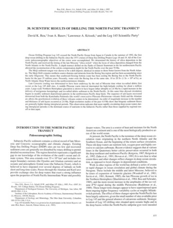
D.K. REA ET AL.to permit generation of latitudinal, longitudinal, and depth transectsto complete the global picture of climate and circulation throughoutthe Neogene.Limited recovery from North Pacific and Bering Sea industry stratigraphic test wells suggests that regional sedimentation in theEocene and early Oligocene was mainly calcareous. This was succeeded by a period of low sedimentation rates continuing until themiddle Miocene, when siliceous sediment began to accumulatethroughout the region (Keller and Barron, 1983). The timing and rateof decreased calcareous and increased siliceous accumulation is notwell known. While plate migration may partially account for thistrend, it does not explain the occurrence of in situ calcareous sedimentation in the Bering Sea or the rapidity and apparent synchroneityof the onset of siliceous sedimentation throughout the North Pacific.The evidence implies a change in regional circulation and productivity from a mid-Paleogene ocean that was warm, stratified, and withnet downward transport (as the North Atlantic today), to a mid-Neogene ocean that was cool and well mixed with net upward transport(Woodruff and Savin, 1989). Such a change would also affect nutrient concentrations downstream, leading to lower silica production inthe Atlantic and Indian oceans, and may signal a change in atmospheric circulation and climate. However, the number and location ofNorth Pacific DSDP sites leave considerable doubt concerning theextent of the change because most of the sites lie near the continentsand their records may reflect changes in the boundary currents, ratherthan in the open-ocean gyre. Leg 145 planned drilling sites within thesubpolar gyre that were expected to permit an assessment of regionalchanges in the mass accumulation rate of silica during the Cenozoicand allow a clear definition of the middle to late Miocene silicaswitch (Keller and Barron, 1983).The response of the North Pacific to major paleoclimatic eventsof the Pliocene, both the mid-Pliocene warm interval centered atabout 3 Ma and the onset of major Northern Hemisphere glaciation at2.6 Ma, is only poorly understood. The record of ice rafting has beenreported from analyses of both piston cores (Conolly and Ewing,1970; Kent et al., 1971) and DSDP cores (von Huene et al., 1973;1976). Much of the DSDP information was summarized by Rea andSchrader (1985) who showed that, although older isolated pebblesoccur, ice rafting effectively began all across the northern Pacific at2.6 Ma (see also Krissek et al., 1985). The oceanic response to the onset of Northern Hemisphere glaciation has been documented fromfaunal and floral abundance patterns, but reliable estimates of changes in biological productivity have not been made. One goal of Leg145 was to determine the fluxes of the biogenic components of thesediment and to interpret those data in terms of past biological productivity.The North Pacific also provides special opportunities to investigate important Oceanographic and climatic phenomena that are eitherbetter displayed there than elsewhere, or may be unique to this basin.One of these opportunities involves the record of atmospheric circulation preserved in the eolian component of North Pacific sediment.Atmospheric circulation and its link to sea-surface circulation and biological productivity is an important component of climatic change.Much of our understanding of this aspect of climate change has comefrom three North Pacific cores (Janecek and Rea, 1983; Rea et al.,1985; Janecek, 1985; Rea, 1994). These cores are generally of lowbiostratigraphic resolution and are all situated along about the samelatitude, precluding any understanding of latitudinal variation in theglobal wind system. Leg 145 sites were chosen to increase the latitudinal span of eolian records which permits enhanced definition ofchanges in atmospheric circulation associated with the Cretaceous/Tertiary and Paleocene/Eocene boundaries (important for comparison to computer models of climate change). The Leg 145 sites alsocan be used to test the suggestion that enhanced Northern Hemisphere atmospheric circulation and concomitant biological productivity were directly responsible for the onset of massive silica sedi-578mentation in the Miocene and to document changes in atmosphericcirculation associated with the Pliocene onset of Northern Hemisphere glaciation.A second special scientific opportunity offered by the North Pacific is to test the relation between spreading center formation (ridgejumps) and hydrothermal activity originally proposed by Owen andRea (1985) and Lyle et al. (1987). Those authors showed that there isan order of magnitude increase in seafloor hydrothermal activity associated with the process of cracking a new spreading center throughold ocean crust. Pelagic clay is a reliable recorder of ocean paleochemistry. Drilling on Leg 145 was planned to recover thegeochemical signal associated with the plate boundary reorganizationthat occurred during the time of the Late Cretaceous magnetic quietzone (Rea and Dixon, 1983; Mammerickx and Sharman, 1988). Therifting episode that resulted in the formation of the Chinook Troughin the central North Pacific is part of this event, and Site 885/886 (justsouth of the trough on somewhat older crust), was planned to recovera clear, proximal geochemical record of the hydrothermal activity associated with intraplate rifting.The final special opportunity provided by North Pacific drillingarises from the presence, on the northeastern flank of the northernEmperor Seamounts, of the Meiji sediment tongue. Geologists haveinterpreted this deposit as being a drift deposit similar to those of theNorth Atlantic (Scholl et al., 1977; Mammerickx, 1985). If true, bottom water has been forming somewhere to the northwest of Detroitand Meiji seamount and moving rapidly to the southeast. Conversely,some physical oceanographers have stated that no bottom waterforms or can form in the North Pacific (e.g., Knauss, 1978; Warren,1983). Determining the nature and age of the Meiji sediment tongue,therefore, was an important target for the Leg 145 drilling.Scientific ObjectivesThese long-standing questions and others were incorporated intothe scientific objectives of Leg 145, the primary goal of which was toenhance our understanding of the paleoceanography and paleoclimatology of the North Pacific Ocean. Specifically, we hoped to be ableto define the following:1. The high-resolution Neogene record of the Subarctic region;2. The nature and history of formation of North Pacific Deep Water;3. The middle Miocene onset of silica deposition—the "silicaswitch" question;4. The Late Cretaceous and Cenozoic record of atmospheric circulation;5. The Late Cretaceous and Cenozoic record of ocean chemistry;6. The record of Northern Hemisphere continental climate;7. The paleoceanography of the late Mesozoic superocean;8. The tephrochronology of the Kuril, Kamchatka, and Aleutianarcs;9. The age and nature of basement in regions where it is poorly understood.Leg 145—the North Pacific TransectLeg 145 departed from Yokohama, Japan, harbor on 24 July 1992,and arrived two months later in Victoria, Canada. The return to thenorthernmost Pacific occurred 21 years after the previous visit to theregion by a drilling ship, during Leg 18 and 19 of DSDP. Leg 145drilled 25 holes at 7 drill sites (Fig. 1, Table 1) and recovered 4321 mof core. New, much more aggressive hydraulic piston-coring techniques, formulated because of the failure of the extended core barrel(XCB) bit to recover diatom ooze at our first drill site, 881, were directly responsible for the recovery of very long advanced piston corer(APC) cores at the ensuing locations. Hole 882A is still the longest
RESULTS OF DRILLING, NORTH PACIFIC TRANSECT150- 60 - 50cNorth Pacific578810577 *ß306173-40 c576% % LL44-GPC3- 30 cFigure 1. Index map of the North Pacific showing the location of Leg 145 drill sites and other ODP and DSDP sites mentioned in the text.Table 1. Location of Leg 145 drill sites.SiteLatitudeLongitudeWaterdepth (m)88188247 06.1 'N50 21.8'N51 11.9'N51 27.0'N44 41.3'N44 41.3'N54 21.9'N161 29.5'E167 36.0'E167 46.1'E168 20.2'E168 16.0'W168 14.3'W148 26.8'W5531324423853826571157133631884886887APC core recovered during the entire Ocean Drilling Program, resulting in 398 m of sediment drilled, 411m recovered. The combination of multiple, long piston cores and clayey sediment at our mid- tohigh-latitude locations enabled the construction of continuous magnetic reversal stratigraphies down to the middle Miocene at nearly alldrill sites. The existence of robust reversal stratigraphies at most sitesallowed the regional biostratigraphy to be correlated directly with thegeomagnetic polarity time scale, which in some cases represents thefirst ever such correlation (Barron et al., this volume).Paleoceanographic results include documentation of the Neogenehistory of silica and carbonate deposition in the North Pacific. Silicafluxes begin to increase slowly at about 12 Ma, and rise sharply to amaximum occurring between about 6 and 3 Ma. The calcite compensation depth (CCD) in the northwestern Pacific has shoaled by about1.5 km since the early Miocene, which was a time when the CCDdeepened in the rest of the world. The modern CCD is about 2 kmshallower on Detroit seamount than it is on Shatsky and Hess rises,only 12 latitude farther south. This is a classic example of CCDshoaling toward regions of high (silica) productivity. Other results include the observation that the middle and later Eocene was a time ofsignificant downslope mass transport of sediment, broadening knownthe aerial extent of this regional process, that has been well documented from sites in the Central Pacific Basin. No reefal or neriticmaterial was found in any of the downslope-transported sections, indicating that Detroit Seamount was never at sea level (Rea, Basov,Janecek, Palmer-Julson, et al., 1993).Leg 145 drilling recovered basement basalt from Detroit Seamount at Sites 883 and 884, and from Patton-Murray seamount plat-form at Site 887. At Site 885/886 a lava flow of basaltic compositionwas encountered beneath about 10 m of nearly pure, almost black hydrothermal ooze. This rock, probably associated with the formationof a new spreading ridge just to the north at the Chinook Trough, hasbeen dated at 80 m.y. old (Keller et al., this volume). Presumably thisextrusive event and subsequent accumulation of hydrothermal materials mark the Late Cretaceous plate-boundary rearrangement, an important event in the evolution of the Pacific Basin (Rea and Dixon,1983; Mammerickx and Sharman, 1988).Confirmation of the Meiji sediment tongue as a drift deposit wasthe major new paleoceanographic discovery of Leg 145. That depositcontains a constant mineralogy (Arnold, this volume) of Siberian origin (Scholl et al., 1977), and diatoms of northern provenance (Barron and Gladenkov, this volume). The Meiji Drift which began forming in the early Oligocene is in all aspects similar to the North Atlantic drifts, except that the pelagic component is siliceous and notcalcareous. The existence of this drift deposit is strong evidence forpersistent northwest to southeast bottom water flow in this part of theNorth Pacific during the past 35 million years (m.y.).SUMMARY OF RECOVERED SEDIMENTAND BASALTSite 881Site 881 was drilled in the deep northwestern Pacific in 5531 m ofwater (Fig. 1, Table 1). The 360 m of sediment penetrated were considered to be a single sedimentary unit with two subunits (Fig. 2).Unit IA, 0-164 m below seafloor (mbsf), is a clayey diatom ooze oflate Pliocene and Quaternary age. Important minor components include ash layers and ice-rafted debris (IRD). This unit grades downward over a depth range of about 20 m into Unit IB, 164-364 mbsf,a diatom and radiolarian/diatom ooze of latest Miocene to latePliocene age. Ash layers and IRD are present in Unit IB but in muchlesser amounts than in the overlying unit. Nannofossils are absent orvery rare, occurring in about 20% of the samples examined. Planktonic foraminifers occurred in one, and benthic foraminifers in three,of the 52 core-catcher samples. Very good age control is provided bythe siliceous microfossils and magnetic reversal stratigraphy.579
D.K. REA ET AL.Site 881Quaternary/ vV VvVvVvV v V VSite 884 / öV V T/ V V V V V% 100 -100 -100 -200200 -200 -300 -300 -300 -398400 -400 -500 -500600 -600 - r v v v v v u. Plio.I. Plio.Site 883V V www100 -200 -Site 882V VV V VV VVVV Vv300 -u. Mio.V V Vf V V "364Site 887Site 885/886200 -300L. MU. MioceneM. Mic100 -100IllVVVVVV- » » :OOlig.U. Mio.L.U.Plio. Plio.PleistPlei jt700 -700 -800800 -849 7 900930Silt and claySiliceous oozeNannofossil oozeDiatomiteCalcareous oozeDiatom Radiolarian oozeNannofossil chalkAshCalcareous chalkBasaltFigure 2. Stratigraphic columns of the Leg 145 drill sites.
RESULTS OF DRILLING, NORTH PACIFIC TRANSECTSite 882Site 882 was drilled on the flank of Detroit Seamount in 3244meters of water (Figs. 1 and 3; Table 1). The 398 m of sedimentdrilled and recovered at Site 882 are all of a single lithologic unit thatcan be subdivided into two subunits (Fig. 2). Subunit IA, 0-110 mbsf,is a diatom ooze with ash, clay, and dropstones. Subunit IB is a diatom ooze with accessory nannofossils and sponge spicules; minoramounts of ash occur in the lower part of Subunit IB. Subunit IA isQuaternary to late Pliocene in age and Subunit IB is late Pliocene tolate Miocene in age. Chronostratigraphic control is provided primarily by diatom zonation and in some intervals by radiolarians andnannofossils. Magnetic reversal stratigraphy at Site 882 is good in themore clay- and ash-rich Subunit IA. The late Pliocene and Quaternary deposits, Subunit IA, are characterized by higher concentrations ofboth volcanic ash and terrigenous material (clay and dropstones) thanis Subunit IB. Dropstones, however, are far less abundant that theyare 500 km to the south at Site 881.clayey diatom ooze. Lithologic Subunit IC, 440-550 mbsf, is an upper Miocene to middle Miocene claystone with accessory diatomsand some chalk. Subunit ID, 550-604 mbsf, is a middle Miocene tolower Miocene diatomite with clay. Unit II is differentiated from theoverlying materials by the presence of reworked materials. SubunitIIA, 604-700 mbsf, is a lower Miocene to lower Oligocene claystonewith minor chalk. This subunit shows evidence of downslope reworked material. Subunit HB, 700-771 mbsf, is an upper Eoceneclaystone conglomerate. Diatoms are no longer present in this part ofthe section, which is dominated by downslope redeposited sediment.Ash layers are present in the lower part of this subunit. Subunit HC,771-854 mbsf, is a middle Eocene to upper Paleocene(?) claystonewith ash. Native copper occurs as bladed and twinned crystals and asstreaks on slickenside surfaces in units as far upcore as Subunit IC(Dickens et al., this volume). Lithologic Unit III, 854-941 mbsf, isbasalt that occurs as 13 units, 10 of which are massive flows. Muchof the basalt has coarse phenocrysts; fresh olivine is found in the lower 50 m of the recovered section. Keller et al. (this volume) have dated these basalts at 81 Ma.Site 883Site 885/886Site 883 was drilled on a level plateau near the summit of DetroitSeamount in 2385 m of water (Figs. 1 and 3; Table 1). The six holesdrilled penetrated 830 m of sediment and 37.5 m into the basalticbasement below (Fig. 2). The sedimentary column can be dividedinto five major units. Sedimentary Unit I (0-86.9 mbsf), composed ofclay with diatoms and quartz, is late Pliocene to Quaternary in age;the Matuyama/Gauss reversal boundary occurs at 84 mbsf. Accessory dropstones characterize this unit, and ash layers are common.Lithologic Unit II (86.9-458 mbsf) is a nearly pure diatom ooze oflate Miocene to late Pliocene age and represents the interval of rapidsiliceous sedimentation recorded at nearby drill sites. Calcium carbonate, present in minor amounts above 458 mbsf, becomes an important sedimentary component below that level. Lithologic Unit IIIis a middle to upper Miocene calcareous diatom ooze in its upper part(Subunit IIIA, 458-597 mbsf) and a lower Miocene diatom nannofossil chalk in its lower portion (Subunit IIIB, 597-655 mbsf). Lithologic Unit IV is an upper Eocene to upper Oligocene nannofossilchalk (Subunit IVA, 655-740 mbsf) grading down to Paleocene toEocene clayey and ashy nannofossil chalk (Subunit IVB, 740-818mbsf). Chert nodules of Oligocene to Eocene age occur in the chalk.An unconformity occurs where much of the upper Oligocene materialis missing; other hiatuses occur in the Eocene and Paleocene parts ofthe section. The lowermost portion of this section, Subunit IVB(740-818 mbsf), displays evidence of downslope displacement ofsediment. Laminated layers, thin turbidites, scour structures, currentripple marks, soft-sediment deformation structures, and debris flowswith matrix-supported clasts of angular ashy chalk all suggest significant redeposition. Partly altered ash and completely altered ash, nowseen as yellow palagonite and smectite, become important components of the sediment near the bottom of the section where theymakes up Unit V (818-830 mbsf).About 35 m of basalt was recovered below the sedimentary section in immediately adjacent Holes 883E and 883F. Basement rock isa series of moderately altered pillow basalt grading from moderatelyto highly plagioclase-olivine microphyric basalt to highly olivineplagioclase microphyric basalt.Site 884Site 884 was drilled on the lower, northeastern flank of DetroitSeamount in 3826 m of water (Figs. 1 and 3; Table 1). Drilling penetrated 854 m of Cenozoic sediment and 87 m of the underlying basalt (Fig. 2). The sediment column can be divided into two main lithologic units, each with subunits. Lithologic Subunit IA, 0-128 mbsf,is a Quaternary to upper Pliocene clay with diatoms. Vitric ash layers,some over 1 m in thickness, and rare dropstones occur in this unit.Subunit IB, 128-440 mbsf, is an upper Pliocene to upper MioceneSite 885/886 was drilled in 5713 m of water in a sediment pondabout 60 km south of the southern margin of the Chinook Trough inthe central North Pacific Ocean (Fig. 1, Table 1). Drilling at Sites 885and 886 encountered 66 and 72 m, respectively, of sediment overlying basalt (Fig. 2). The sedimentary sequence can be divided intothree units: clay with diatoms, diatom ooze, and clay. Unit I, 0-17mbsf, is a Quaternary to upper Pliocene clay with diatoms and spicules. Unit II, 17-50 mbsf, is an upper Pliocene to upper Miocene diatom ooze with clay. Large manganese nodules, both brown andblack in color, occur at mid depth in this unit, roughly 40 mbsf. UnitIII, 50-66 mbsf, is clay. This unit is the deep chocolate color of theclassic North Pacific "red" clays. Lithologic Unit IV, 66-66.5 mbsf,is basalt that has been baked to a yellow-brown color and is recoveredonly as pieces of rubble. Keller et al. (this volume) have dated the basalt from Site 885/886 at 80 Ma.Site 887Site 887 was drilled in 3631 m of water in the Gulf of Alaska onthe platform level of the Patton-Murray Seamounts (Figs. 1 and 4;Table 1). Drilling at Site 887 penetrated 289 m of sediment and 84 minto the top of the underlying seamount platform basalt-sediment edifice (Fig. 2). The sedimentary sequence can be subdivided into threeunits. Unit I, 0-90 mbsf, is a Quaternary to upper Pliocene siliceoussilty clay (Subunit IA, 0-45 mbsf) and clay (Subunit IB, 45-90 mbsf). Dropstones are numerous and ash layers common in Unit I. UnitII, 90-270 mbsf, is an upper Pliocene to middle Miocene siliceousooze with rare carbonate. Unit II can be subdivided into three subunits. Lithologic Subunit IIA, 90-171 mbsf, is effectively a pure diatom ooze of Pliocene age. Subunit HB, 171-236 mbsf, is an upperMiocene calcareous diatom ooze, and Subunit HC, 236-270 mbsf, isa middle Miocene siliceous ooze. Lithologic Unit III, 270-289 mbsf,is a sparsely fossiliferous clay presumably of early Miocene age thatoverlies basalt. Hole 887A recovered several meters of basaltic peagravel in a clay slurry at the base of Unit III. Unit IV, 289-373 mbsf,is basalt that, from drilling, appears to occur in flows or sills interbedded with at least two layers of sediment.PALEOGENE PALEOCEANOGRAPHYLate Paleocene to Early Oligocene Isotopic RecordThe Paleogene section of the northwestern Pacific was continuously cored three times at Detroit Seamount, once with the XCB bit(Hole 883B) and once by standard rotary drilling (Hole 883E). AtHole 884B, the Paleogene section was cored using the XCB bit (Fig.581
D.K. REA ET AL.Detroit Seamount51 36'N i51 00 T50 00'166 42'E167 00168 00'Figure 3. Bathymetric map of Detroit Seamount showing locations of Sites 882, 883, and 884. (Contouring by C. Brenner.)168 36'
RESULTS OF DRILLING, NORTH PACIFIC TRANSECT55 ? 00'N54 30154 00'53 30'-151 00'E-150 00'-149 00'-148 00'Figure 4. Bathymetric map of Patton-Murray seamount group showing the location of Site 887. (Contouring by C. Brenner.)3). Together these sites provide a lower or middle Oligocene throughEocene section, but essentially no Paleocene or older biogenic sediment. The lowermost (foraminifer-bearing) sample in Hole 883B isuppermost Paleocene (Pak and Miller, this volume). The Oligoceneto Eocene carbonate deposits of Detroit Seamount are disturbed byslumping and other downslope redepositional processes, more so atthe deeper Site 884 than at Site 883, but it is possible to construct areasonable stratigraphy from them (Basov, this volume). As suchthey provide the northernmost paleoceanographic record of middepth waters for the large Paleogene Pacific Ocean.Pak and Miller (this volume) have analyzed benthic foraminifersNuttallides and Cibicidoides from Sites 883 and 884 for oxygen andcarbon isotopes (Fig. 5). The combined records from the two sitesshow characteristic paleoceanographic signatures, including (1) thelarge shift in oxygen and carbon isotopic values associated with thePaleocene/Eocene boundary; (2) the light 6 18 O values (indicatingwarmth) associated with the early Eocene; (3) the cooling step thatoccurs at the early/middle Eocene boundary; and (4) the large positive shift in δ l 8 0 values that occurs in the earliest Oligocene and denotes the onset of Antarctic glaciation (Pak and Miller, this volume).Planktonic foraminifer assemblage information also defines the earlyEocene as being the warmest interval within the entire Paleogene section (Basov, this volume).The most complete Paleogene isotope record from the North Pacific is from Site 577 on southern Shatsky Rise (Miller et al., 1987),about 2200 km to the southwest of Detroit Seamount. Pak and Miller(this volume) combine the three records to construct a North Pacificcomposite record that clearly shows the response of the large Pacificreservoir to the isotope-paleoceanographic events of the period between about 60 and 30 Ma (Fig. 5).Slumping and Downslope Redepositional ProcessesWithin the more than 4 km of hemipelagic and pelagic sedimentthat were recovered during Leg 145, the most impressive sedimentary structures were those documenting sediment mass transport eventsin the vicinity of Detroit Seamount (Fig. 6). At Site 883, which is theshallowest site occupied on Detroit Seamount, redeposited sedimentforms the lower to middle Eocene lithologic Subunit IVB, which liesin the depth interval 740-814 mbsf. At Site 884, the deepest site occupied near Detroit Seamount, redeposited sediment is more thantwice as thick and forms the Eocene and Oligocene section of Lithologic Unit II, which lies at 604-771 mbsf. The oldest sediment recovered at Site 882, the intermediate depth site on Detroit Seamount, waslate Miocene in age and showed no evide
Proceedings of the Ocean Drilling Program, Scientific Results, Vol. 145 38. SCIENTIFIC RESULTS OF DRILLING THE NORTH PACIFIC TRANSECT1 David K. Rea,2 Ivan A. Basov,3 Lawrence A. Krissek,4 and the Leg 145 Scientific Party5 ABSTRACT Ocean Drilling Program Leg 145 crossed the North Pacific Ocean from Japan to Canada in the summer of 1992, the first