Transcription
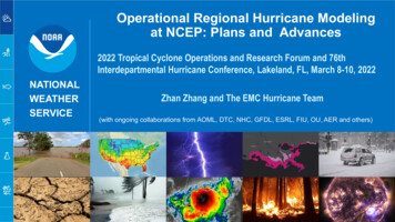
Operational Regional Hurricane Modelingat NCEP: Plans and Advances2022 Tropical Cyclone Operations and Research Forum and 76thInterdepartmental Hurricane Conference, Lakeland, FL, March 8-10, 2022NATIONALWEATHERSERVICEZhan Zhang and The EMC Hurricane Team(with ongoing collaborations from AOML, DTC, NHC, GFDL, ESRL, FIU, OU, AER and others)Department of Commerce // National Oceanic and Atmospheric Administration // 1
Outline Operational hurricane forecast systems: HWRF/HMON GFSv16/RTOFS impact on HWRF/HMONTrack/Intensity forecast performance in 2021HWRF/HMON porting on WCOSS2 Hurricane Analysis and Forecast System (HAFS) real timeexperiments for 2021 Hurricane Season ConfigurationsTrack/Intensity forecast verification HAFS Initial Operational Capability (IOC) Proposed configuration Component development TimeLine and future planNATIONAL WEATHER SERVICEBuilding a Weather-Ready Nation // 2
Current Operational Tropical Cyclone Prediction Models at NCEPHWRFHMONDynamic coreNon-hydrostatic, NMM-ENesting13.5/4.5/1.5 km; 77 /18 /6 ; 75 vertical 18/6/2 km; 75 /12 /8 ; 71 verticallevels; Full two-way movinglevels; Full two-way movingDA andInitializationVortex initialization, Self-cycled hybridEnKF-GSI with inner-core DA (TDR)Modified vortex initialization,no DAPhysicsUpdated surface (GFDL), GFS-EDMFPBL, Updated Scale-aware SAS,NOAH LSM, Modified RRTM, F-A MPSurface (GFDL), GFS-EDMFPBL, Scale-aware SAS, NOAHLSM, RRTM, F-A MPCouplingMPIPOM, RTOFS, WaveWatch-IIIHYCOM, RTOFS, No wavesHurricane Elsa, 05L, 2021Non-hydrostatic, NMM-BPost-processing NHC interpolation method, UpdatedGFDL trackerNHC interpolation method, GFDLtrackerOperationalforecastsAll global basins (NHC/JTWC), max. 7TCs on-demandNHC basins, max. 5 TCs,on-demandComputationResources91 nodes in 98 mins43 nodes in 100 minsHWRFHMONNote: Items in Green are similar/same; Items in Red are differentDepartment of Commerce // National Oceanic and Atmospheric Administration // 3
GFS v16 Downstream Impacts on Hurricane Forecast ModelsImpact on HWRFTrack ForecastIntensity ForecastP-W relationshipRI POD/FARNATLPositive at all leadtimes ( 5%)Positive at most of the lead times, exceptfor marginally negative at day 1 and 5.ImprovedImprovedPOD/FAREPACSignificantly positiveat all lead times, 20% at day 4-5Neutral overall.Negative between hrs 30-60 but positivefor longer lead times at Days 3-5.NeutralDegradedPOD/FARImpact on HMONTrack ForecastIntensity ForecastP-W relationshipRI POD/FARNATLNegative at all leadtimes after day-1( 5%)Positive at all lead times, 10% betweenday 2-4ImprovedDegraded PODNeutral FAREPACSignificantly positiveafter day 1, 10% atday 4-5Neutral before day 3, Significantlypositive at day 4 and 5 ( 20%)ImprovedImprovedPOD/FARNote: Retrospective testing based on 2018-2020 stormsDepartment of Commerce // National Oceanic and Atmospheric Administration // 4
Operational HWRF/HMON/GFSTrack and Intensity Errors for nt of Commerce // National Oceanic and Atmospheric Administration // 5
Operational GFS, HWRF and HMON: 2021 Season Summary NATL Basin: Operational HMON has the best intensity skill with HWRF matching skill for the first twodays and then again on Day 5. Average max errors are 12 kts at Day 5. Operational HMON has the best track skill for Days 1-4 while GFS had the lowest trackerrors for Day 5. EPAC Basin: Both HWRF and HMON had good intensity skill for days 1-4 and GFS and HMON forDay 5. Overall, intensity errors are higher than for NATL basin. All operational models have similar track errors with GFS having the best skill for Days 4and 5. WPAC Basin: Operational GFS has the best track skill at all lead times.Operational HWRF had the lowest intensity errors for the first 2 days with GFS doingwell for the longer lead times.Department of Commerce // National Oceanic and Atmospheric Administration // 6
Transition to HAFSDepartment of Commerce // National Oceanic and Atmospheric Administration // 7
Hurricane Analysis and Forecast System (HAFS):A collaborative Project in the UFS Framework Develop UFS based cloud-allowing HAFS to replace current NOAA’s operationalhurricane forecast systems, HWRF and HMON HAFS Initial Operational Capability (IOC) is proposed for implementation inFY23 All decisions on HAFS IOC based on EMC and NHC science evaluations Maintain current CONOPS: max 5 storms in NHC AOR for HMON max 7 storms for HWRF in all global basins (NHC, CPHC and JTWC) i.e. total max12 storms Requires two configurations for HAFS IOCDepartment of Commerce // National Oceanic and Atmospheric Administration // 8
Real Time Demo of HAFS Model top 3km (ESG), L91/10hPa 13-3km global-nest,L75/2hPa 3km (ESG)/L91, 10hPa 6km, L64, 10hPaDomain 94º 65º, 3121 2161Global ATM:(C768), NestATM: 79º 43ºOCN: 330º 89º 94º 65º,3121 2161 86º 58º,1441 6hrlyCouplingOcean TOFSv2No ocean modelNSSTDataAssimilationNoNoYes (addl:TDR, METAR,meso GOES-R AMVs)NoRadiationRRTMG fGWDM-TKE-EDMF/M-GFSorographic GWDM-TKE-EDMF/M-GFSsaGWDM-TKE-EDMF/M-GFSorographic GWDM-TKE-EDMF/M-GFSorographic MNOAHNOAHNOAHNOAHHAFSs have skillful track forecasts thanHWRFHAFSs mostly improvedover HWRF after 48h*None of the HAFS configurations tested thus far contained moving nest capability.Department of Commerce // National Oceanic and Atmospheric Administration // 9
HAFS IOC Primary Configuration -- Storm-centric withone moving gStorm-centric withone moving nest,parent: 86x86degree, nest: 19x19 degreeRegional (regularGnomonic or ESG), 6/2 km, L81, 2 hPa model topStorm inner-coreDA, cycling forNATL/EPAC TCs,VITwo-way HYCOM,one-way WW3coupling for NHCAORPhysics*ComputerresourceHAFSv0.3A/GFSlike CCPP physicssuite 6,000 cores perstorm x 12 storms 72,000 coresThe primary configuration will replace current operational HWRF,providing TC forecast guidance in all global oceanic basins, 7storms maximum.ATM ParentATM NestHYCOM OceanWW3 Wave*A secondary configuration will be derived using alternate physicsto replace current operational HMON, providing TC forecastguidance in the NHC basins, 5 storms maximum.*Subject to change based on T&E and available computer resourceExpecting allocation of 3.5x than currently used for hurricane models onWCOSS2Department of Commerce // National Oceanic and Atmospheric Administration // 10
The HAFSv0.3A Baseline Configuration(Based on the 2021 HAFS.v0.2A experiments) Use the feature/hafsv0.3 baseline6-km for parent and 2km for moving nest, in regulargnomonic grids, L81 (2 hPa top) vertical levelsTurn on topography smoothing for model stabilitydt atmos 90s; parent: k split 2, n split 5, nest:k split 5, n split 9 for 2-km nest,updated saSAS convection; Noah MP; uGWPv1ATM ParentATM NestHYCOM OceanWave DomainDepartment of Commerce // National Oceanic and Atmospheric Administration // 1111
Critical Components of HAFS Development, T&E, andTimelines for ImplementationDepartment of Commerce // National Oceanic and Atmospheric Administration // 12
Summary and Future Plans FY22 Hurricane season – OperationalHWRF & HMON have been ported toWCOSS2Hurricane Analysis and Forecast System(HAFS) real time HFIP experiments for the2022 Hurricane Season (08/01 -- 11/01)FY23 – targeted for HAFS IOCDepartment of Commerce // National Oceanic and Atmospheric Administration // 13
Thank You!Department of Commerce // National Oceanic and Atmospheric Administration // 14
FY2021 HWRF/HMON Configurations for Different TC BasinsModelBasinOcean CouplingWave CouplingData AssimilationEnsemble DAHWRFNATLPOM RTOFSWW3 1-wayAlwaysTDR/priority storm 75 level10 mbHWRFEPACPOM RTOFSWW3 1-wayAlwaysTDR/priority storm 75 level10 mbHWRFCPACPOM RTOFSWW3 1-wayNoneNone75 level10 mbHWRFWPACHYCOM RTOFSNoneNoneNone75 level10 mbHWRFNIOHYCOM RTOFSNoneNoneNone75 level10 mbSHNATL/EPAC/HMONCPACHYCOM RTOFSNoneNoneNone75 level10 mbHYCOM RTOFSNoneNoneNone71 level50 mbHWRF VerticalTopEnKF self-cycled DA system for one TDR or priority storm75 vertical levels with 10-hPa top for all global TC basinsOcean coupling for all global TC basins (POM for NHC basins, HYCOM for JTWC basins)POM RTOFS initialization for NATL/EPAC/CPAC basinOne-way coupling to wave model for NATL, EPAC, and CPACSea surface wave IC/BC come from global wave modelDepartment of Commerce // National Oceanic and Atmospheric Administration // 15
The HAFSv0.3A Baseline Configuration(Based on the 2021 HAFS.v0.2A experiments)ATM Parent ; ATM Nest,HYCOM Ocean Wave The FV3ATM component Use the feature/hafsv0.3 baseline branch with its subcomponents syncedwith their latest authoritative branches (as of 05/01/2021) 6-km for parent and 2km for moving nest, in regular gnomonic grids withthe L81 (2 hPa top) vertical levels Turn on topography smoothing for model stability when moving nestinteracting with steep topography, full zs filter .T., n del2 weak 15(24), max slope 0.25 (0.12/0.3/0.4) GFSv16 netcdf files for IC; 3-hrly GFSv16 grib2 files for LBC dt atmos 90s; parent: k split 2, n split 5, nest: k split 5, n split 9 for2-km nest, radiation time step: 1800s; LBC blending (nrows blend 10) Use the HAFS V0 gfdlmp nonsst physics suite GFDL microphysic; RRTMG radiation; updated saSAS convection;MP-LSM; GFS surface layer with HWRF exchange coefficients; GFSEDMF PBL with HWRF modification; uGWPv1; Turning off the NSSTcomponent The HYCOM component CMEPS based ocean coupling withthe bilinear regridding method 1/12-degree NATL domain(1-45.78N, 261.8-352.5E) with L41 Ocean IC from RTOFSv2 andpersistent oceanic LBC Atmospheric forcing from GFSv16grib2 files for non-overlap areaDepartment of Commerce // National Oceanic and Atmospheric Administration // 1616
Domain 94º 65º, 3121 2161 Global ATM:(C768), Nest ATM: 79º 43º OCN: 330º 89º 94º 65º, 3121 2161 86º 58º, 1441 1081 IC/BC GFSv16/3hrly GFSv16/3hrly GFSv16/3hrly GEFS/6hrly Coupling Ocean IC CMEPS-HYCOM RTOFSv2 CMEPS-HYCOM RTOFSv2 CMEPS-HYCOM RTOFSv2 No ocean model NSST Data Assimilation No No Yes (addl:TDR, METAR, meso GOES-R AMVs) No
