Transcription
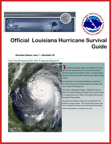
Official Louisiana Hurricane SurvivalGuideHurricane Season June 1 — November 30Are You Prepared for this Tropical Season?The Gulf Coast region offers many benefits for its people who call Louisiana home. The area is full of culturaldiversity, agricultural and fishery riches, a thriving ecologyand many events and outdoor activities that make Louisianaunique.A consequence of enjoying this lifestyle is preparing forhurricane season and associated hazards from high winds,storm surge and flooding rains.This guide is developed through a collaborative partnership of the NOAA National Weather Service and the Stateof Louisiana Governor's Office of Homeland Security andEmergency Preparedness.The guide is provided to assist you in preparing for theAtlantic hurricane season. We all hope these actions willnot be needed this season, but the looming threat alwaysmakes preparedness a necessity every year.
Official Louisiana Hurricane Survival GuidePage 2A Message from LA Governor Bobby JindalDisasters can occur anywhere at anytime. At a moment’s noticecitizens may need to move quickly out of harm’s way. Governmentagencies have planned and are prepared for possible emergenciesthat might arise. It is important that you and your family have aplan as well.This guide will assist you and your family with creating such a plan.I encourage you to study this guide so you can be best preparedto evacuate safely from impending threats should the need occur.In the event of an emergency, stay alert and pay attention to thenews and announcements in your area if a situation develops. Formore information, please visit the Governor’s Office of HomelandSecurity and Emergency Preparedness (GOHSEP) website athttp://gohsep.la.gov or www.getagameplan.org.Sincerely,Bobby JindalDefinitions and TerminologyTropical Disturbance A weak organization of clouds, rain and thunderstorms in the tropics thattypically moves east to west. A small percentage of these systems intensify to tropical storms andhurricanes. These disturbances are monitored and upgraded by the National Hurricane Center(NHC).Tropical Cyclone The generic name for all low pressure systems that form in the tropics or near tropicalwaters that are not frontal in nature. These are inclusive of depressions to hurricanes in the Atlanticand eastern Pacific Oceans, but are also typhoons in the western Pacific Ocean.Tropical Depression A tropical cyclone that has maximum sustained winds of 33 kts or 38 mph.Tropical Storm A tropical cyclone with sustained winds between 34 kts (39 mph) and 64 kt (73 mph).Hurricane A well developed tropical cyclone with sustained winds in excess of 64 kt (73 mph).Intensities are reported on the Saffir-Simpson scale ranging from Category 1 (weakest) to Category 5(strongest).Tropical Storm Watch Posted by the NHC for a stretch of coast line when tropical storm conditions arePOSSIBLE in the next 48 hours.Tropical Storm Warning Posted by the NHC for a stretch of coast line when tropical storm conditions areEXPECTED in the next 36 hours.Hurricane Watch Posted by the NHC for a stretch of coast line when hurricane conditions are POSSIBLEwithin the next 48 hours.Hurricane Warning Posted by the NHC for a stretch of coast line when hurricane conditions areEXPECTED within the next 36 hours.
Official Louisiana Hurricane Survival GuideSupply SuggestionsPage 3Use these suggestions as a guide for gathering your hurricane supplies. Remember these critical points. Get a 2 week supply of these emergency necessities. Store clean up and repair supplies in your safe room. Make your hurricane kit portable if you live in an evacuation area. Don’t forget special supplies for babies, the elderly and dependentpersons. Review homeowner’s or renter’s insurance plans as it relates tonatural disasters.Hurricane Kit Alarm Clock (battery operated Cooler for water Prescriptions, including eyeglasses Baby Food, diapers and formula Driver’s license Non-electric can opener Battery or crank operated radio or TV Eating and cooking utensils NOAA All Hazards radio Enough batteries for radio, flashlights forseveral days Emergency cooking facilities (grill or camp stove) Blankets and pillows Extra pet food Bleach (without scents or additives) Fire extinguisher Butane Lighter First aid kit and manual Canned and dried food Flashlights (one for each member) Cans, gas and oil Fuel up the vehicles Cash, credit cards Gas for the grill Cellular phones Heavy work boots or shoes Change of clothes Important phone numbersPots and pans Portable cooler Sleeping bags, sheets, towels Soaps, shampoo and toiletries Sponges and paper towels Toilet paper and towelettes Toys (to occupy children) Water Purification tablets Water jugs, 1 gallon per person per day. Feminine hygiene productsValuable Papers Social security cards Insurance policies Inventory of household goods Birth certificates Deeds and mortgages Computer file backups Marriage and death records Stocks and bonds Pictures (both personal and of belongings) Wills Small valuables Savings and checking booksClean Up and Repair Supplies Axes Cleaning supplies Inflatable raft Bars, wrecking and crow Duct and masking tape Ladders Brooms Drills and bits Lanterns and fuel Camera to record damage Extension cords Lumber Chain, steel Generators Mosquito propellant Chain saw and fuels Hammers and hatchets Plastic trash bags Caulk and caulking gun Heavy plastic tarps Nails, screw, bolts
Official Louisiana Hurricane Survival GuideSaffir Simpson ScalePage 4Hurricanes are rated by wind intensities on a scale developed by engineer Herbert S. Saffir and meteorologist RobertH. Simpson in the late 1960s. The scale is comprised of 5 intensities of sustained wind.CategorySustained Wind (mph)Type of DamageLast LA Hurricane174 to 95MinimalCindy (2005)296 to 110ModerateGustav (2009)3111 to 130ExtensiveKatrina and Rita (2005)4131 to 155ExtremeAudrey (1957)5Greater than 155CatastrophicCamille (1969)Hurricane HazardsStorm Surge, Storm Tide and InundationStorm surge is the increase in sea height due tothe strong circulation of wind and reduction in airpressure. This surge is in addition to any normaltide range that occurs daily. The combination ofnormal tide and storm surge is known as StormTide. These combined water levels can reach 20to 30 feet in very large and powerful hurricanes.Hurricane Camille in August 1969 produced a 24foot storm tide along the Mississippi Coast. Hurricane Katrina in 2005 produced a 27 foot stormtide also along the Mississippi Coast.If one subtracts the elevation of the land or floorelevation of a structure, the resulting water level iscalled Inundation. In some coastal locations that mayactually be below sea level, inundation can be particularly hazardous. During Katrina, many locations hadbetween 8 and 14 feet of inundation in low lying areas.
Official Louisiana Hurricane Survival GuideWindsTornadoesHurricane force winds candestroy homes and mobilehomes. Signs, roofing materialand small objects left outsidebecome flying missiles. Windscan attain hurricane strength,over 74 mph, well inland before weakening. Powerful Hurricane Katrina attained hurricane force winds and producedwidespread wind damage intocentral and eastern Mississippi.Hurricane Gustav in 2008 produced hurricane force winds inthe Baton Rouge area. Peopleoutside during hurricane forcewinds are in great danger ofbeing struck by flying objects.Hurricanes and tropical stormscan and often produce tornadoes. Tornadoes can form inthunderstorms embeddedwithin the outer bands of atropical cyclone or within theeyewall of hurricanes. Hurricane Hilda in 1964 producedmany tornadoes along its trackinto Louisiana. Hurricane Andrew produced a killer tornadoin Laplace before landfall insouth-central Louisiana.Page 5A powerful tornado struck Laplace, LA several hours before the landfall of Hurricane Andrew in August 1992.Inland/Freshwater FloodingTropical Storms and hurricanesare efficient rain-makers. Thesestorms are harbingers of tropical moisture that typically fall atrates of several inches perhour. The accumulation ofrainfall is related to the forward speed of the storm. Slowmoving or nearly stationarystorms can produce 20 to 30inches of rainfall or more in aday. Storms that move intomountainous or hilly terraincan have enhanced heavy rain-fall due to the lift provided bythe higher terrain. This affect,in turn, can produce mud slidesand mud flows. The torrentialrains and flood threat canreach hundreds of miles inlandfor several days after a storm’slandfall. Such was the case withTropical Storm Allison in 2001when this slowly moving tropical storm produced over 40inches in the Houston, TXmetro area. This was the costliest tropical storm in U.S.history due primarily to freshwater flooding in southeastTexas and Louisiana. 23 deathswere reported in Texas andone in Louisiana.Downtown Houston, TX after torrential rains fromTropical Storm Allison in 2001.
Official Louisiana Hurricane Survival GuidePage 6Before a Storm StrikesWhen in a Watch Area Frequently monitor radio, TV (local and cable), NOAA All Haz-When in a Warning Areaards Radio, or Internet for official bulletins of the storm’s progress. Continue to monitor the storm’s progress. Complete preparation activities. If evacuating, leave early during daylight hours. Stay at an inland location Prepare to secure or store lawn furniture and other loose, lightweight objects such as garbage cans, garden tools, etc. with family, friends, a low rise motel or a designated shelter.Prepare to cover all windows and door openings with shuttersor plywood - Tape on windows is useless. Notify someone outside the evacuation area of your plans.If evacuating, leave early and orderly when your area is desig- Follow instructions issued by local officials. Leave immediately if told tonated to leave, preferably in daylight. Service and fuel family vehicles.Check batteries and stock up on canned foods, first aid supplies,do so. drinking water and medications. Inspect and secure mobile home tie downs. Add more if needed. Have cash.Ensure pets are secured and safe. Most shelters will not accept pets.Some hotels are pet-friendly. Out-of-town kennels may also receive pets. Leave mobile homes in any case.During a StormIf Staying at Home Only stay at home if you have NOT been ordered to evacuate by local officials. Know how to turn off utilities if told to do so by authorities. Post a set of instructions for other family members tofollow. Have necessary tools on hand to turn valves off. Fill bathtub and large containers with water for sanitary purposes. Ensure you have a battery operated radio, flashlights, extra batteries, canned goods and a non-electric can opener. Remove objects that could become missiles. Turn refrigerator to max setting and open only when necessary. Freeze water to create ice. Ensure an adequate supply by storing extra in large bags Turn off propane tanks. Do not run gas powered generators in an enclosed area. Do not connect generators to your main home power supplywithout proper installation by a qualified electrician.During Strong Winds Stay away from windows. Secure and brace all door and window openings. If near the water, stay on the first floor but be prepared to move quickly to the second floor as water rises. If away from the water, stay on the lowest floor, preferably in an interior bathroom or closet. Lie on the floor under a table or other sturdy object.
Official Louisiana Hurricane Survival GuidePage 7After the Storm Keep monitoring radio and TV, if possible. Use telephones, including cell phones, to report life-threatening emergencies only. Texting may be more reliable after a storm. Do not drink or prepare food with tap water until you are certain it is not contaminated. Boil water before using for drinking or food preparation, until your local officials declare the water supply safe. Stay on firm ground away from high water. Avoid using candles and open flames indoors. Use a flashlight to inspect for damage. Do not drive in areas where roads are closed. Do not drive around barricades. Check gas, water, electrical lines and appliances for damage. Always assume downed power lines are charged. Wait until an area is declared safe before entering. Be especially cautious using chainsaws and other power tools to remove debris. Avoid crossing weakened bridges and washed out roads. Do not drive into flooded areas.Hurricane FactsHow Hurricanes FormHurricanes are products of a warm,moist atmosphere over a very warmbody of tropical water.They are typically steered by easterlywinds that flow in the lower latitudes,generally between 10 degrees and 25degrees latitude.As disturbances move over warm oceanwaters, a heat engine process developsthat causes a low pressure circulation toform. This is usually the tropical stormphase.As the tropical storm continues tostrengthen and the circulation buildsupwards into the higher atmosphere, ahurricane is created.Hurricane StructureThe center, or eye, of a hurricane is relatively calm with sinking air. The most violent winds and heaviest rains are found in the eyewall.The large circulation of a hurricane involves the transport of unstable air towards its main center. Theresulting showers and thunderstorms form into spiral rainbands that may extend several hundred milesaway from the actual center.The rainbands often feature gusty winds in squalls that arise rather abruptly, followed by heavy rainfall.Some cells within the rainbands can have rotation that produce tornadoes, particularly those in theforward right quadrant of the hurricane, relative to the storm’s forward motion.As hurricanes move over land and weaken, much of the energy used to maintain the storm at sea isnow transformed into violent wind gusts and downdrafts, along with torrential rainfall, especially atnight and in higher terrain.
During a threat of a hurricane, a phased evacuation will be based on geographic location and time in which tropical storm winds areforecasted to reach affected areas.Phase I – 50 Hours before onset of tropical storm winds. Includes area south of the Intracoastal Waterway. These areas are outside anylevee protection and are vulnerable to Category 1 and 2 storms. These areas are depicted in RED on the Evacuation Map. During phase I, thereare no route restrictions.Phase II – 40 hours before onset of tropical storm winds. Includes area south of the Mississippi River which are levee protected but remainvulnerable to Category 2 or higher storms. These areas are depicted in ORANGE on the Evacuation Map. During Phase II, there are no routerestrictions.Phase III - 30 hours before onset of tropical storm winds. Includes areas on the East Bank of the Mississippi River in the New OrleansMetropolitan Area which are within levee protection system but remain vulnerable to a slow-moving Category 3 or any Category 4 or 5 storm.These areas are depicted in YELLOW of the Evacuation Map. During Phase III, certain routes will be directed and the Contraflow Planimplemented.Phased evacuation procedures are for the traffic management purposes only. Consult your local Office of Emergency Preparedness Directorfor further evacuation information.
Emergency Shelter Information PointsEvacuation Area of the StateInformation Point LocationAddressRe-entry from Mississippi onU.S. 65 & U.S. 841. Tourist Welcome CenterU.S 165 & U.S. 84 1401 Carter StreetVidalia, LARe-entry from Mississippi on I-202. Tourist Welcome Center836 I-20 West, Tallulah, LAFrom Southeast area on LA 13. Paragon CasinoParagon Place, Marksville, LAFrom Southeast/Central area on I-494. Sammy’s Truck StopI-49, Exit 53, 3601 LA 115 WBunkie, LAFrom Southeast/Central areason U.S. 715. Med Express Office7525 U.S. 71, Alexandria, LAFrom Southeast/Southwest/ Centralareas on U.S. 171 and I-496. P.E. Gym - LSU-ShreveportOne University Place, Shreveport, LAFrom Southwest on U.S. 1717. Pickering High School180 Lebleu Rd., Leesville, LAFrom Southwest/Central areason U.S. 1658. Tourist Information Center8904 U.S. 165, Oberlin, LAFrom Southeast area on LA 19. Maddie’s Truck Plaza15972 LA 1, Simmesport, LASafe and Well Websitewww.redcross.org/safeandwell or in Spanish at www.sanoysalvo.orgAfter a disaster, letting your family and friends know that you are safe and well can bring your loved ones great peace of mind. This website isdesigned to help make that communication easier.List Myself as Safe and Well Required information includes name, home address, phone number, current city and stateRegistrants can add personal messageRegistrants can update their Facebook and Twitter status via Safe and WellFor those without Internet access, or for those in need of translation services, call agents at 800-733-2767 can help with registration duringlarge-scale disastersAccess and Privacy Publicly accessible on the Internet 24/7/365 Paper registration forms are available for back-data entry Registration and search help is available a large-scale disasters at 800-733-2767Search and Results Search for a Safe and Well record:1. By Last Name and Phone Number, or2. By Last Name and Complete Home Address
65190AdamsHomochitto NFEast Feliciana1012Iberville1861Misiss24Miles110I-10 West CONTRAFLOWI-55 North CONTRAFLOWI-59 North CONTRAFLOWAscension10Assumptionsippi RiverBaton RougeEast Baton RougeI-12 West to US 190 West NORMAL FlowFelicianaI-10 West to I-59North NORMAL FlowWest61Causeway to I-12 West to I-55 NorthNORMAL FlowI-10 East to I-59 North NORMAL FlowI-10 Westto I-55 North NORMAL FlowWilkinsonI-10 West NORMAL FlowContraflow CrossoverIndex Map Reference0 3 61LegendSOUTHEAST LOUISIANAEVACUATION PLANLOUISIANAMISSISSIPPIAmiteSt. James190Mile Marker 31End ContraflowRejoin NormalTraffic FlowWalthallLawrenceTangipahoaSt. Charles310LakePJefferson31 290a inontc hartrI-55 Northfrom I-10 West5I-12 Westto US 190 WestSt. TammanyMarionPlaqueminesNew Orleans510US 190(Causeway)to I-12 West190Orleans610981190La k4PearlPearlRiverRiverStSt De Soto NFHattiesburgI-59 Northfrom I-10 Westinto Mississippi11Mile Marker 55End ContraflowRejoin NormalLamarTraffic FlowCovingtonI-10 East3 Lanes onTwin Spans10e B o rgPearl RiverSlidellI-59 NorthCONTRAFLOWinto MississippiWashingtonCovingtonMississippi Travel Information:http://www.gomdot.comPikeLincolnI-55 Northfrom I-12 Westinto MississippiLafourche51St. John the BaptistI-10 WestCONTRAFLOWto LaPlace6165155LakeMaurepasHammondEnd ContraflowRejoin NormalTraffic FlowLivingston12I-55 NorthCONTRAFLOWSt. Helenainto Mississippi84BrookhavenCopiahHattiesburgSoutheast Louisiana CONTRAFLOW PLAN
Southeast Louisiana CONTRAFLOW MAP INSETS3!ClearI-10 @ VETERANS BOULEVARDMETAIRIE2!I-10 @ WILLIAMS BOULEVARDKENNER1!I-10 @ CLEARVIEW PARKWAYMETAIRIEview Pa§ 10rkway§ § 10Veterans BoulevardWilliams BoulevardVeterans Boulevard10Enter I-10 CONTRAFLOW (From Northbound or SouthboundWilliams Blvd.) Via the I-10 East Exit Ramp at Williams Blvd.§ 4!59I-10/I-12 @I-59SLIDELLEnter I-10 West Via the Normal Westbound Entrance Ramps.Northbound Traffic on Clearview Pkwy. Can Enter I-10 CONTRAFLOWVia the I-10 East Exit Ramp at Clearview Pkwy.Enter I-10 East Via th eNormal Eastbound Entrance RampFrom Clearview Pkwy.Enter I-10 West Via the Normal Westbound Entrance Ramps.Enter I-10 CONTRAFLOW (From Eastbound or WestboundVeterans Blvd.) Via the I-10 East Exit Ramp at Veterans Blvd.Enter I-10 West Via the Normal Westbound Entrance Ramps.5!190 I-12 @ US 190COVINGTON6!§ 55I-12 @ I-55HAMMOND§ 12§ 1251 § § 1012§ 10Two Lanes From I-10 East (Left and Center Lanes) Crossover andProceed on I-59 North CONTRAFLOW.One Lane From I-10 East (Right Lane) Continues onto I-50 North.US 190/ Causway Diverts to I-12 West.I-10 West (All Lanes) Diverts to I-59 North.I-12 West Diverts to US 190 West.I-12 West (All Lanes) Diverts to I-55 North.I-55 North (All Lanes) Cross over and Proceede on I-55 NorthCONTRAFLOW.Phase III Contraflow InstructionsI-10 West Contraflow Lanes:· The eastbound and westbound lanes of I-10 for Clearview Parkway in Metairie to I-55 North inLaPlace will be used as westbound lanes. On the Contraflow Plan, the normal westbound lanes areshown with BROWN arrows and the Contraflow ( eastbound) lanes are shown with BLUE arrows.· All I-10 West entrances through New Orleans, Metairie, and Kenner will be used intheir normalmanner to gain access to I-10 West.I-55 North Contraflow Lanes:· The northbound and southbound lanes of I-55 from I-12 in Hammond to the Mississippi state linewill be used as northbound lanes. On the Contraflow Plan, the normal northbound lanes are shownwith RED arrows and the Contraflow (southbound) lanes are shown with BROWN arrows.· Traffic traveling I-55 North (Brown) will be diverted onto I-55 North Contraflow and will only beallowed to exit at two locations: Exit 47 ( LA-16) in Amite and Exit 61 ( LA-38) in Kentwood.I-59 North Contraflow Lanes:· The northbound and southbound lanes of I-59, north of the I-10/I-12/I-59 interchange, will be usedas northbound lanes. On the Contraflow Plan, the normal northbound lanes are shown with PURPLEarrows and the Contraflow (southbound) lanes are shown with GREEN arrows.BROWN Arrows ( I-10/I-55 North to Hammond and Mississippi):· In LaPlace, the I-10 West (BROWN) lanes will be diverted to I-55 North toward Hammond andMississippi. Traffic will not be allowed to continue on I-10 West at this interchange.· All traffic traveling on I-55 North will travel in the existing northbound lanes.· When traffic traveling on I-55 North reaches the I-55/I-12 interchange in Hammond, I-55 will beginto Contraflow (both the north and south lanes will travel north into Mississippi).BLUE Arrows ( I-10 West to baton Rouge):· Traffic destined for Baton Rouge may enter the Contraflow (eastbound) lanes from ClearviewParkway, Veterans Boulevard or Williams Boulevard in Jefferson Parish (see diagrams).· Traffic destined for Baton Rouge may enter the Contraflow (eastbound) lanes from I-10 West via across-over at the Clearview Parkway overpass. This is the only opportunity to enter the Contraflow(eastbound) lanes from I-10 West without exiting and re-entering the interstate.· In LaPlace, I-10 Contraflow traffic (BLUE) will be diverted onto the westbound lanes of I-10 and willcontinue west on I-10 toward Baton Rouge.RED Arrows ( Lake Pontchartrain Causeway to Covington, I-12, Hammond, Mississippi:·Northbound traffic on the Lake Pontchartrain Causeway ( RED) will be diverted onto I-12 West (RED)at the US-190/I-12 interchange and will continue on I-12 West to Hammond.·I-12 West (RED) will be diverted onto I-55 North (RED) at the I-12/I-55 interchange in Hammond·I-55 North (RED) will continue north into MississippiGREEN Arrows (I-10 East to I-59, North to Slidell, Mississippi):· I-10 East Traffic (GREEN) from New Orleans will cross the I-10 Twin Spans using the three eastboundlanes.· Contraflow of I-59 will begin at the I-10/I-12/I-59 interchange.· At the I-10/I-12/I-59 interchange, the left and center lanes of eastbound I-10 will be diverted ontosouthbound I-59 (GREEN). Only the right lane will continue onto I-59 North (PURPLE).· The I-10 East (GREEN) traffic will not be allowed to continue on I-10 East or enter I-12 West.PURPLE Arrows (I-59 North to Mississippi from I-10 West):· I-10 East traffic (GREEN) from New Orleans will cross the I-10 East twin spans using the threeeastbound lanes.· Only the right lane (GREEN) will continue to I-59 North (PURPLE)· All traffic of I-1o West (PURPLE) from Mississippi will be diverted on I-59 North (PURPLE) at theI-10/I-12/I-59 interchange.· I-10 West traffic will not be allowed to continue westbound on I-10 or I-12.Orange Arrows (I-12 Westbound- Covington/Hammond):· Traffic traveling on I-12 West (RED) between Covington (US-190) and Hammond (I-55) will NOT beallowed to continue on I-12 West. This traffic must divert onto I-55 North.· Traffic traveling on I-12 West between Slidell (I-10/I-12/I-59 interchange) and Covington (US-190)will NOT be allowed to continue on I-12 West. This traffic will be diverted to US-190 West.· Traffic traveling on US-190 West will be allowed to continue to Baton Rouge.All Interstate exit ramps will be open to normal traffic flow. Interstate exit ramps in the Contraflow laneswill be limited and marked with variable message boards.Study this map and CHOOSE YOUR ROUTE WISELY. There will be many restrictions on the Interstatesystem. Upon entering the contraflow area, it may not be possible to change routes. Contraflow operationswill begin when evacuations are initiated in Jefferson and Orleans parishes. If you do not wish to evacuateunder the contraflow restrictions, your best strategy is to LEAVE EARLY before the contraflow is activated.
SouthWEST Louisiana EVACUATION MAP GrantNatchitochesSabineSOUTHWEST LOUISIANAEVACUATION PLAN165La Salle§ 49Alexandria³Legend Concordia1! *1Vernon17116771I-10 East / US 165 NorthNORMAL FlowWilkinsonFort PolkUS 171 Northto ShreveportAdamsIndex Map ReferenceI-49 North NORMAL FlowRapidesUS 171 North NORMAL Flow 165US 90 North NORMAL FlowAvoyelles 190De RidderWest Feliciana 71US 165 Northto Alexandria 167BeauregardAllenEvangelinePointe CoupeeSt. LandryExit 19Eastbound US 190 OpenWestbound US 190 Closed 190 190 190EuniceEuniceOpelousasExit 18OpenDeQuincyDeQuincyIberville§ Exit 11Open10AcadiaJefferson Davis1!Calcasieu 902!§ St. Martin10CrowleyCrowley 210LakeCharles3!§ JenningsJennings90LafayetteLafayette 167Vermilion0 2.5 51« 171101520MilesI-10 Eastbound andUS 171 NorthboundmToShreveport2« 90NewNewIberiaIberia3« 165I-10 @ US 165InterchangeI-10 @ I-49Interchangem§ 49mTo ShreveportTo Alexandria§ 10§ 10mTo LafayetteIberia Cameron§ 10VU§ 14210§ 10mTo Lafayette 90§ 10 167 165 All exits along Interstate 10 will be open.Interstate10 east and west traffic will be able to access US 171 north toShreveport at exit 33. Interstate 10 east and west traffic will be able to access US165 north to Alexandria at exit 44 No route restrictions apply and no specific traffic controlmeasures are planned other than to monitor traffic flow§ 10
Official Louisiana Hurricane Survival GuidePage 12Your National Weather ServiceNational Hurricane CenterHurricane Hunter AircraftNWS MISSION STATEMENT:An Integrated Service Delivery“.to provide weather and floodwarnings, public forecasts andadvisories for all the UnitedStates, its territories, adjacentwaters and ocean areas,primarily for the protection of24 X 7 Forecaster WeatherWatch with State-of -theScience AWIPS computersGOES continuousSatellite SurveillanceWSR-88D Radarlife and property.”Emergency Alert SystemWe’re now on Facebook!Website: http://www.weather.govThis national alert system was designed to provide crucial information to the general public for the express purpose of protecting youfrom harm during emergency situations and natural disasters. Thisalert system is tested weekly and monthly on local and cable TV outlets as well as appointed Emergency Alert System commercial radiostations. The NOAA All-Hazards Weather Radio program is a vitalpart of the Emergency Alert System, disseminating timely warningsfor various weather threats 24 hours a day. In addition to weatherhazards, All Hazards Radios also broadcast Amber Alerts for abducted children, Shelter-in-Place notifications for hazardous materialsincidents, and other threats to national security.NOAA All-Hazards Radio Louisiana FrequenciesLake Charles KHB-42LafayetteNOAA All Hazards Radio Receiversavailable from retailers and internetoutlets.162.400 MHzWXK-80 162.550 MHzBogalusaWNG-521 162.525 MHzAlexandriaWXK-78162.475 MHzBaton Rouge KHB-46162.400 MHzNatchitoches WXN-87162.500 MHzMorgan City KIH-23162.475 MHzShreveportWXJ-97162.400 MHzMonroeWXJ-96162.550 MHzBurasWXL-41 162.475 MHzNew Orleans KHB-43 162.550 MHzBeaumont, TX WXK-28162.475 MHzGulfport, MS162.400 MHzKIH-21
Official Louisiana Hurricane Survival GuidePage 13Preparing Your AnimalsMaking plans for your family is extremely important. Don’t forget toplan for the animals in your life! The location of your evacuation destination may or may not accept pets, so call aheadand check. Animal shelters will be set up in various part of the state on an ―as-needed‖basis. The Louisiana Department of Agriculture & Forestry works year round with theLouisiana State Animal Response Team (LSART) to provide sheltering opportunities.Species-specific disaster preparedness advice is available at www.lsart.org. Create a disaster readiness kit for your animal that includes food, water, first aidsupplies, feeding supplies and other items that are necessary to keep your animalcomfortable for at least 3—5 days. Mike Strain DVMCommissionerRemember, animal ownership is a responsibility! Be ready to take care of your wholefamily.What is 2-1-1? 2-1-1 is an easy to remember telephone number that connects callers to information about critical health and humanservices available in their community during crisis or any time. 2-1-1 responds immediately and directs callers to services most appropriate for their needs. For example, 2-1-1 can offer access to: Coordinated Disaster InformationFood, ClothingSheltersSpecial Needs HousingVolunteer ManagementEvacuation Routes Transportation AssistanceCrisis CounselingPrescription AssistanceMissing PersonsPost Disaster Child CareRebuilding AssistanceHow does 2-1-1 Work in Louisiana? Call 2-1-1 from any landline or cellular phone in Louisiana Staffed 24/7 with trained specialists to guide you to vital resources Provides multilingual services and information for the hearing impaired Maintains a computerized database of over 15,000 resources and services statewide It is the largest comprehensive information and Referral system in Louisiana, serving 64 parishes
Official Louisiana Hurricane Survival GuideContact InformationPage 14Governor’s Office of Homeland Security andEmergency PreparednessNational Hurricane Centerwww
Official Louisiana Hurricane Survival Guide Supply Suggestions Page 3 Get a 2 week supply of these emergency necessities. Store clean up and repair supplies in your safe room. Make your hurricane kit portable if you live in an evacuation area. Don't forget special supplies for babies, the elderly and dependent persons. Review homeowner's or renter's insurance plans as it relates to


![[ST] Survival Analysis - Stata](/img/33/st.jpg)