Transcription
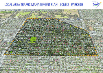
LOCAL AREA TRAFFIC MANAGEMENT PLAN - ZONE 2 - PARKSIDEGREENHILL ROADGLENOSMOROADTONLARUNFULLEYROADNDDROAWATTLE STREET1
CONTENTS1. INTRODUCTION 31.1 LATM Prioritisation Study31.2 Strategic overview 41.3 Purpose of a LATM Study42. METHODOLOGY 53. CONTEXT 64. TRAFFIC DATA 74.1 Warrants 74.2 Speed Volume94.3 Crash Data 114.4 Origin Destination124.5 Parking Data 135. COMMUNITY ENGAGEMENT146. RECOMMENDATIONS 187. APPENDICES 302180717 Revision A180719 Revision B180724 Revision C
1. INTRODUCTION1.0 IntroductionThe City of Unley has been progressively completing a series of local area trafficmanagement (LATM) studies across the City. This latest study includes the areabounded by Greenhill Road, Glen Osmond Road, Fullarton Road, Wattle Street andUnley Road.The study has been undertaken by Council’s Transport and Traffic team, and is basedlargely on existing data and knowledge of the area from previous feedback from thecommunity, generally focussing on three themes: Parking Walking and CyclingLATM 1LATM 2UNDERTAKEN2015-16UNDERTAKEN2014-15 Traffic Management and SafetyFollowing the analysis of data, Council undertook a comprehensive engagementprogram with the local community. It was evident during the community engagementprocess that local residents and businesses are generally supportive of solutions to theidentified issues.LATM 5LATM 3UNDERTAKEN2013-14LATM 6LATM 4Recommendations address the key traffic related issues in a systematic manner whileminimising impacts on local residents. However, as is the case with any traffic/parkinginterventions, there will be some residents/businesses that will be impacted, but willoverall result in positive change to traffic, parking and road safety issues.1.1 LATM Prioritisation StudyLocal area traffic management (LATM) is the planning and management of road spacewithin a local area. It considers neighbourhood level traffic-related problems, andproposes solutions in context of the local area, rather than in isolation.Figure 1.1 Local Area Traffic Management Study Areas, City of UnleyIn order to establish these ‘local areas’, a LATM Prioritisation Study was undertaken,where the City of Unley was divided into 36 precincts that are bounded by naturaltraffic boundaries (e.g. tram/train lines, arterial/collector roads). These 36 precinctswere combined into six LATM study areas, which are depicted in Figure 1.1. The LATMPrioritisation Study compared these areas based on community concerns received,crash history (safety issues), and traffic data, which informed a relative priority. ThisLATM is area 2, which was considered the second highest priority of the six areas.3
1.2 Strategic Overview1.3 Purpose of a LATM StudyLocal area traffic management plays a key role in delivery of the Unley IntegratedTransport Strategy, and in turn the City of Unley Community Plan 2033 (refer to Figure1.2 for the strategic planning hierarchy). Measures resulting from LATM directlysupport objectives of these strategies:The objective of a LATM study is to achieve acceptable levels of traffic volume andspeed, and improve the general amenity of the area. This can create safer and morepleasant streets.Community Plan 2033 and Four Year Delivery Plan 2017-2021Community Living theme Objective 1.5 - Our City is connected and accessible Strategy 1.5a Ensure an effective network for all modes of transport. Strategy 1.5b Encourage walking and cycling as methods of transport. Strategy 1.5d Manage parking across the city to maximise its availability.These objectives are primarily achieved through influencing driver behaviour,either through physical influence on vehicle operation, or by influencing the driver’sperception of what is appropriate behaviour in a street or area.In order to meet these objectives, a LATM study considers traffic volumes, trafficspeeds, crash history, parking, local street connectivity and proximity to main roads,and also community perceptions regarding traffic issues.Tools available include the use of physical devices, streetscaping treatments andother measures such as parking controls and regulatory signs.The need for LATM arises from:Unley Integrated Transport Strategy An intent to reduce traffic-related problems,Active Transport focus area orderly traffic planning and management (i.e. to align with a desired roadhierarchy), Unley is recognised as a leader in providing connected, efficient and safe activetransport choices. a desire to improve the community space and sense of place, Active transport options are more utilised by the local community. a desire to improve environmental, economic and social outcomes,Parking focus area a need for traffic interventions associated with new development, Unley is recognised for its proactive, innovative, and customer centric approach toparking management. the implementation of pedestrian and bicycle plans and other policies/strategies. Equitable and convenient parking options are delivered throughout the City.Traffic Management and Road Safety focus areaTraffic problems include: Traffic safety, leading to measures to control traffic speeds and behaviour, Unley is recognised as a leader in road safety and traffic management outcomes. protection or improvement of local amenity focussing on appropriate allocation,design and use of street space. Safety is at the core of all of our infrastructure, traffic and transport managementinitiatives.Management involves: Unley’s street and path networks provide effective, safe routes for all users. Coping with the pressure of traffic growth, the need to reduce traffic impacts on resident amenity, spill-over from traffic routes – restraints on ‘rat-running’, direction of traffic to the most appropriate routes, creating conditions for safe and comfortable cycling and walking.4Figure 1.2 Strategic Planning Hierarchy
2. METHODOLOGYMethodologyPreliminary projects identified based on:The LATM study process consisted of four stages:Identify issues1. IdentifyPotential issues were identified through historical knowledge of the area andcommunity perceptions, issues/projects highlighted in the Walking and Cycling Plan,and where aligned with State Government funding opportunities. Council strategy Concerns raised over a number of years Opportunities with other projectsEngage communityThe community were engaged on identified issues and general feedback was soughtto understand any other key transport related priorities of residents and businessesin the area.Determine desired outcomes2. EngageEngage with community to obtain feedback onpreliminary projects and provide opportunity forstakeholders to raise other concerns/optionsCommunity feedback and both existing and new traffic data was analysed in detail todetermine desired outcomes for the area.Recommend actionsIndividual issues were investigated and 30 recommendations were developed andprioritised.3. DetermineDetermine whether thereis support/opposition toproposed preliminary projects& whether there are anyother common concernsor suggestions evident infeedbackAnalyse traffic data: Volume/Speed Origin/Destination Crash/ParkingAdditional projects basedon feedback and data4. RecommendFigure 2.1 Methodology Flow ChartLATM recommendations developedand prioritised5
3. CONTEXTTLESTAMFORD STREETJAFFREY STREETGEORGE STREEUEANGLO AVENTMONTPELIER STREETPORTER STREETDOUGLAS STREELISTON STREETGCHINONERSTNOSMONDTYPICAL LAND LEST ANNS PLACENED STREETSTREETOXENBOULDALFRCLYDE STREETTETGEORGE STREREGENT STREETTOWNSEND STREEMIX OF OFFICE ANDRETAIL/HOSPITALITYMONDTYOUNG STREEPARKSIDECIVIC/COMMUNITYFACILITIESROADPARKSIDE PRIMARYSCHOOLTST RAPHAEL'SSCHOOLKENILWORTHELLA STREETTLEICESTER STREETLEICESTER STREEETSTREROADINREKLETSTACYTGEORGE STREEMDATROBSART STREEVETROBSART STREEDUNKS STREETOSCASTLE STREETYOUNG STREEPINE STREETTDUDLEY STREEHONE STREETTWHITTAM STREEFULLER STREETTTCOLLINS STREETARNOLD STREEMAUD STREETHILL STREETDUTHY STREETCELANGBLYTH STREETUEEDMUND AVENCAMBRIDGECASTLE STREETKENILWORTHBLYTH STREETTFAIRFORD STREEWALLIS STREETTFAIRFORD STREETFAIRFORD STREETRANDOLPH STREEFULLARTONAUDLEY CTTUNLEYPRIMARYSCHOOLTWATTLE STREEFigure 3.1 Land Use Context6MALVERNWINDSOR STREETDUTHY STREETTGREVILLE STREETCREMORNE STREECREMORNE STREETST HELEN STREEFOSTTERRACEUEEDMUND AVENNELLY STREETTFOSTER STREEER STREETUERUGBY STREETTOWN HALLLIBRARYVARIOUS CHURCHESST SPYRIDON COLLEGEHAM TERRACEOXFORD TERRAOLIVE STREETROADCEOXFORD TERRAUNLEY OVALDWILKINSON ROACOOTRA AVENUNLEYDUTHY STREETCETRIMMER TERRATFREDERICK STREEDBIRKS STREETTPARINGA STREEOAFULLARTON RSCOTT STREETCAMBRIDGEMARION STREEMYRA STREETWINDSOR STREETCAMPBELL ROADTRUGBY STREETMAUD STREETTERRACEUNLEY ROADCULVERT STREEETWATTLE STRETWATTLE STREESUNRISECHRISTIANSCHOOLFULLARTON ROADOffice type land use along Greenhill Road results in legitimate through traffic toGreenhill Road as well as high demand for on-street parking. Five schools in the areaadd additional pressure to the traffic network, particularly during the 8-9.00am periodwhich coincides with the peak traffic period where motorists travel to work. Thissuggests that there is legitimate traffic accessing the residential street network andany measures to discourage rat-running should take this into consideration.DTPORTER STREECongestion is experienced at major intersections, including Unley Road/GreenhillRoad, Fullarton Road/Glen Osmond Road and Greenhill Road/Glen Osmond Road, aswell as George Street/Greenhill Road to a lesser extent. This can lead to rat runningbehaviour through residential streets.ADGREENHILL ROGREENHILL ROAUNLEY ROADThe LATM area is bounded Greenhill Road, Unley Road, Wattle Street, FullartonRoad, and Glen Osmond Road. The Adelaide CBD, located to the direct north of theLATM study area, results in significant north/south through traffic along the arterialroads of Unley Road, Fullarton Road, Glen Osmond Road, and the major collector roadof Duthy/George Street to a lesser degree.
4. TRAFFIC DATA4.1 WarrantsWhen using traffic data to aid decision making, there is ideally an agreed level or condition where action is warranted (i.e.traffic volume over a certain value). Establishing when LATM action is necessary or desirable is often based on warrants orother objective measures of relative need, usually referring to traffic speeds, traffic volumes, or crash rates. There is no agreedor formally-adopted statement of conditions in Australian Standards or Austroads Guides at which LATM measures must beimplemented. These conditions must be determined based on the individual circumstances and with professional judgement oftraffic engineering practitioners, and expectations of the community. Austroads Guide to Traffic Management Part 8: ‘Local AreaTraffic Management’ suggests that the categories set out in Table 4.1 should be adopted.Problem level andlikely responseTechnical CriteriaResponse/ActionAbove the problem warrantlevel or threshold, i.e. fails thedeficiency standardThe problem is significant enough to be included on afunded treatment program, in order of funding prioritiesAcknowledged technicalproblemSatisfies the deficiency standardbut fails the desirable planningstandardAcknowledged problem justifying investigation, but notsufficient to attract funding in the short-term. Alternative(non-LATM) low-cost approach may be consideredPossible technical problemAchieves the planning standardbut conditions are perceived tobe above tolerance levels forsome in the communityThere may be a problem, but not so serious as to attractfunding, even in the longer-term. Alternative (non-LATM)low-cost approach may be consideredBelow majority tolerance levelsand thus clearly achieves theplanning standard although somenegative community reports mayoccasionally occurUnlikely to be requiredSubstantial problem(a deficiency)Warrants for the City of UnleyWarrants for the City of Unley are based on objective measures and community perceptions. Objective measures include, forexample, the traffic volume that could cause delays at intersections, speeds at which it is difficult for pedestrians to cross a road,or speeds where it is potentially unsafe for bicycles and motor vehicles to share the road.An understanding of community perceptions is developed through interactions with the community in the LATM 2 area, andthrough other LATM’s in the City of Unley, to determine what is perceived as appropriate. There is often a threshold whereresidents start to consider traffic a problem.However, the role and function of a street must also be considered as well as traffic generators on the street or in the area. Forexample, a street adjacent a school may have a high percentage of traffic during the peak morning or afternoon period. This maynot be considered acceptable for residents, but may not be considered a problem objectively as that is the role of the street.Table 4.2 sets out the general warrants applicable for the City of Unley for 40km/h residential streets. Analysis of daily trafficvolumes, 85th percentile speeds, and peak volumes through the LATM area support these values.No agreed problemTable 4.1 Problem categoriesApplicablein residentialstreets onlyDaily TrafficVolume85thpercentilespeed% of dailytraffic inpeak AM% of dailytraffic inpeak PMCasualtycrashes in 5year periodSubstantialproblem (adeficiency) 3000 / 50 20 203 Acknowledgedtechnical problem 200048-4917-2017-203 Possible technicalproblem 150046-4714-1614-163 No agreedproblem 1500 / 45 13 13 edTable 4.2 Traffic warrants for the City of Unley7
DefinitionsDaily traffic volumeTotal number of vehicles recorded travelling past a particular point in a road over a24 hour period. Ideally an average of weekdays across an entire year is used. Dataprovided in this report is an average of two week days, typically a Tuesday andThursday.The average daily traffic volume for the area is 981 vehicles per day.85th percentile speedSpeed at which 85% of vehicles travel at or below under free flowing conditions pasta nominated point (AS1742.4) i.e. 15% of vehicles travel at the 85th percentile speedor higher. This provides a measure of the frequency and extent of speeding. This ismore useful than a mean (or average) speed as a mean speed is affected by outliers(if several vehicles travel at a very low speed past the measurement point it willimpact the average and distort the data).Free flowing conditions are periods when traffic is not significantly delayed by hevolume of vehicles. As roads within the LATM area are free flowing for the majorityof the day, the highest 15% of vehicle speeds measured is considered accurate.The average 85th percentile speed for the area is 41.9km/h (on 40km/h roads only).Although this is above the speed limit, 85th percentile speeds up to 10% over thespeed limit is commonly observed. It is important to consider this when assessingindividual streets/intersection treatments.Average for the area is 13.7% and 11.5% in the AM and PM respectively.Casualty crashA casualty crash consists of an injury or a fatality involving a pedestrian, cyclist,or driver. The Department of Planning, Transport and Infrastructure compile thisdata and analyse it over the previous five years. A single casualty crash does notnecessarily indicate a traffic hazard. If three crashes have occurred, this suggeststhere could be a pattern. Much higher casualty crash rates occur on arterial roadsdue to the higher traffic volume and speed. The majority of collisions are rear endcrashes at signalised intersections and right turn crashes when motorists turn out ofside streets. Although turning restrictions or median treatments on DPTI controlledarterial roads could reduce right turn cashes, treating safety hazards on DPTI roads isnot within the scope of this LATM.Property damage only crashA property damage only (PDO) crash not resulting in a reported injury. This is morecommon than a casualty crash, particularly in a 40km/h area where modern vehiclesprotect occupants. In the traffic engineering industry, less weighting is placed on aPDO crash as funds are more effectively spent addressing locations where there hasbeen a casualty. This is due to the higher financial costs to the community associatedwith treating injuries or due to fatalities.Average Daily Traffic Volume981 vehiclesper day85th Percentile SpeedAverage Speed41.9 KMHAverage 85th percentile speed for the area is 41.9km/h.Percent of daily traffic volume in peak AM and PM hoursThe percentage of traffic considered appropriate is generally based on residents’perceptions. Figure 4.1 indicates that in the PM peak period, most streets are withinthe 8-12% range. Percentages within the AM period extend across a wider range andare more variable. It shows that there are a number of streets with a high percentageof daily traffic in the AM, suggesting these streets are used as part of a rat run.Although it should be noted that the peak school drop-off period usually coincideswith the peak traffic period in the AM, whereas these do not coincide in the PM, somarginally higher percentages are expected in the AM in particular streets.8% of Daily Traffic Volume13.7% AMProportion of trafficThe percentage of traffic travelling along a street, in the busiest hour in the AM andPM periods, is used to determine whether the street is used as part of a rat run/short cut. Generally, in a residential street, it is common for 10% of the daily trafficvolume to use the street in each of these hours. This would consist of residents goingto and from their homes, any visitors, and some through traffic accessing other localstreets or businesses. This varies depending on the various land uses and residentialdensity. As an example, if a street carried 1000 vehicles per day, approximately100 would generally use the street in the AM peak hour (8-9am in most cases), andapproximately 100 would generally use the street in the PM peak hour (often either3-4pm, 4-5pm, or 5-6pm).11.5% PM% of daily traffic volume in peak periodsFigure 4.1 Peak period traffic volume graph
4.2 SPEED VOLUMETraffic speed and volume summaryChinnLegenderSubstantial ProblemStreettGeorge StreetPorter StreeteStamford StreGreenhill RoadThe adjacent figure provides a summary of streets considered a possible orsubstantial problem based on traffic data. Refer to Appendix A for traffic volume,speed, and peak AM and PM data for individual streets.Unley RoadYoung StreetPossible ProblemGlenOsmondRoadParkside PrimarySchoolSt Raphael’sSchoolRobsart StreetBelgrave CtLeicester StreetMarion StreetFullarton RoadCastle StreetUnley PrimarySchoolCambridge TceEdmund AvetWindsor StreearyTown Hall LibrChurchesgeSt Spyridon ColleDuthy StreetUnleyOvalKenilworth RoadRugby StreetOxford TceMaud StreetWattle StreetSunriseChristianSchool9
Speed and Volume InsightsGreenhill Road1. Porter Street1innerStreetGlenOstYoung Street high AM peak volume due to school and potentially rat running.Unley Road3. Young Street2CheStamford StrePorter Street2. Stamford StreetStamford Street experiences a very high AM peak volume, potentially due to ratrunners. This is an acknowledged problem and further investigation is required.George StreetHigh AM volumes. This street acts as an exit out of the local area and for trafficintending to do a U-turn on Greenhill Road and travel East. Negative impact of thisvolume on the cycling route should be considered. Possible technical problem further investigation required.Robsart StreetHigh AM peak volume due to school. Intervention to reduce this would be ineffectivedue to required access to the school. An improved school crossing and measures atintersections will limit negative impacts of this. Further investigation required.4St Raphael’sSchoolMa 5cklinStreMarion Streetet8Oxford TcearyTown Hall LibrChurchesgeSt Spyridon Colle8. Kenilworth RoadRelatively high daily volumes and high AM peak volumes. Speeds within accetpableparameters in most sections. Acknowledged problem. Further investigation required.Unley PrimarySchoolCambridge TceEdmund AveWattle StreetSunriseChristianSchoolFullarton Road7Castle Street7. Oxford TerraceUnleyOvaltWindsor Streederick Street6 FreDuthy StreetHigh daily volume and low-moderate peak volumes suggests this street is for localaccess throughout the day. Measures may not be effective in reducing volumes.Further investigation required.Kenilworth Road6. Frederick Street10adMaud StreetHigh AM peak volume due to school. Intervention to reduce negative impact onpedestrians and residents could be considered. Further investigations required.High daily volume. Land use and connection to Unley Road means that this volume isappropriate for the role of the street and it is not desirable to shift this traffic to otherstreets. Measures to address the negative impact of high volumes (whilst not aimingto reduce volumes) could be considered. Further investigation required.RoRobsart StreetLeicester Street5. Macklin StreetndParkside PrimarySchool3 Young Street4. Streets around Parkside Primary Schoolmo
4.3 CRASH DATA393Ch24Street10 CrashesGlen0-10 CrashesOsmondRoadYoung Street Parkside PrimarySchoolSt Raphael’sSchoolRobsart Street4tDunks Street4er5tTownsend StreeYoung Street4LegendinnJaffrey Street7George Street5737Porter StreetveLeicester StreetDaCrash data includes both ‘Casualty’ (injury or fatality) crash data and ‘Propertydamage only’ data available through the State Government. As mentioned in theWarrants section of the report, generally crashes are considered likely one-offincidents unless there is three or more crashes at a location to suggest a pattern orincreased likelihood of a crash. This suggests that, disregarding those on arterialroads, there are few locations within the LATM area that have experienced a highnumber of crashes. Several locations where there have been multiple crashes arediscussed in Appendix C.Greenhill RoadUnley RoadCrash data is used to determine whether there are particular deficiencies orhazards in the road network that could be addressed. Crashes generally occur dueto human error and to a greater extent on higher speed and higher volume roadswhere there are a high number of traffic movements to and from the road. Thisresults in a high number of crashes at signalised intersection. Locations with ahigh number of crashes on roads under the care and control of the Department ofPlanning, Transport and Infrastructure are generally out of scope for the LATM.ySCrash Data 2012-201642Hone St 546Oxford Tce3UnleyOvalaryTown Hall LibrChurchesgeSt Spyridon ColleUnley PrimarySchool84Cambridge TceEdmund Ave9Fullarton Road4Frederick StreetKenilworth RoadMarion StreetCastle Street5Campbell RoadtWindsor StreeMaud StreetDuthy Street397Wattle Street4SunriseChristianSchool911
4.4 ORIGIN DESTINATIONOrigin-destination data involves matching vehicles (using number platerecognition) at various intersections within a road network to understand theroutes they take. This can help quantify and understand rat running throughthe area. Stations are chosen at likely locations where vehicles enter andexit the area. If they are matched, it suggests that they are taking a short cutthrough the area, which is undesirable as it unnecessarily congests the area andimpacts resident amenity. Surveys were undertaken during the 8-9am period onWednesday 22 November 2017 in the northern Parkside area and on Tuesday 28November 2017 in the Unley area.AREA 1Greenhill RoadChinnARerEAStr Regent Street/Montpelier/Anglo rat run Young/Alfred/St Ann’s rat run2 Kenilworth- Greenhill rat runeet1028teStamford Stre8George Street48 vehicles used Regent Street as part of a rat run to avoid the George Street/Greenhill Road intersection.38Unley RoadRegent Street2Porter StreetNote that vehicles dropping off children at nearby schools and then leaving thearea are also included.AREA 1Further investigation is required for:7Regent StreetYoung StreetParkside Primary81 SchoolRobsart StreetGlenOsmondRoSt Raphael’sSchooladAREA 2Stamford StreetData does not conclusively suggest the area is used as part of a rat run. Northbound residents or staff of businesses in the area may access Cambridge Terracefrom Wattle/Fisher Street, and then disperse through Area 3 at Edmund Avenue.The number of matched vehicles in these streets is not high relative to the dailytraffic volumes, suggesting that this is not a major concern for residents.12Edmund AveUnley PrimarySchool302226Cambridge TceCambridge/Edmund/Oxford TerracearTown Hall LibresChurchgeSt Spyridon Colle39Wattle StreetSunriseChristianSchoolFullarton RoadAREA 333 59yUnleyOvalCastle Street81 vehicles were recorded on Kenilworth Road and exited at StamfordStreet. A portion of this is likely to be school traffic.45tWindsor StreeKenilworth RoadOxford TceAREA 3Duthy StreetData suggests that 7, 28 and 10 vehicles respectively turn from GlenOsmond Road and exit on to Greenhill Road from Stamford Street, avoidingthe Glen Osmond Road/Greenhill Road intersection.Marion StreetKenilworth RoadYoung/Alfred/St Ann’s PlaceMaud StreetRugby StreetData suggests that approximately 100 vehicles from Glen Osmond Roadand Kenilworth Road rat run through Area 2 and use Stamford Street toaccess Greenhill Road. This partially explains the approx. 300 vehiclesusing the street in the 8-9am period.
4.5 PARKING DATAParking DataGreenhill RoadNote that there are parking time limits in all streets north of Young Street, and, ingeneral, most streets south of Young Street are unrestricted (i.e. no parking controls).ChLegendinnerStrSubstantial ProblemPossible ProblemeetteStamford StreGeorge StreetPorter StreetParking occupancy data was collected a typical weekday. Parking is considered apossible problem if a street is 50-70% occupied, and a substantial problem if it is80% occupied or more.Unley RoadRegent StreetYoung StreetParkside PrimarySchoolGlenOsmondRoSt Raphael’s adSchoolRobsart StreetMaud StreetFullarton RoadKenilworth RoadCastle StreetaryTown Hall LibrChurchesgeSt Spyridon ColletWindsor StreeUnleyOvalDuthy StreetRugby StreetOxford TceMarion StreetEdmund AveCambridge TceUnley PrimarySchoolWattle StreetSunriseChristianSchool13
5. COMMUNITY ENGAGEMENTResidents, businesses, and property owners were consulted in September/October2017, with 4850 letters sent to stakeholders, in addition to online engagement. Theapproach involved highlighting potential projects and areas of concern we werealready aware of. These potential projects were developed based on knowledge ofthe area and concerns raised by residents over a number of years. In addition to this,particular projects had already been identified in the Walking and Cycling Plan or tohelp achieve Council goals in the Community Plan 2033/Four Year Delivery Plan.Community members were provided a plan showing potential projects for the area(Figure 5.2) and asked to provide feedback by completing a survey (Figure 5.1). Theywere also provided an opportunity to raise any additional projects/concerns they had.Pay ForAREAUse ParkingTrial 1. DO YOU HAVE ANY COMMENTS ON THELOCALTRAFFICPOTENTIAL PROJECTS HIGHLIGHTED IN THEMANAGEMENTSTUDYATTACHMENT?We are seeking your commentson the Pay for UseParking Trial and Parking Managementin yourarea. Feedbackreceived untilWeare seekingyour viewswillandbeexperiencesas a 31 January 2017, and will be compiledinto a reportto be presentedto Councilat February 2017 Council meeting. Your feedbackMOTORIST,CYCLISTOR PEDESTRIANMOVINGwill help Councilto makean informeddecision on the future of the trial.THROUGHAND LIVINGIN THELATM STUDYAREA. Feedback will be received until 29Please provide your contact details (your personal details will not be made public without yourOCTOBER2017 and will be considered bywritten approval).Council’s ‘City Development – Transport’ team &NamePhone numberused to determine priority outcomes from theLATM.PLEASEAddressPROVIDE YOUR CONTACT DETAILS:Name1. If you are located within the 4 hour parking trial area, do you support theretention of the 4 hour parking zone in your street?AddressYesNo2. DO YOU HAVE ANY COMMENTS ABOUTWALKING/CYCLING/DRIVING/PARKING IN THELATM STUDY AREA?Would you like to receive LATM updates via email?YesNoPhone numberEmail2. Do you have any comments on the trial of parking ticket machines onBartley Crescent Wayville?Return this form by 29 OCTOBER 2017 either byusingthe reply paid envelope provided or posting to:LocalArea Traffic Management StudyCity ofUnley, PO Box 1, Unley SA 5061Provide feedback online by visiting the Local AreaTrafficManagement study online communityOR143. Have youexperienced any changes to parking in your street since the startengagementpage at:trialengagementin February2016?Figureof5.1 theCommunityfeedbackform
Potential Projects Identified(subject to further investigation/prioritisation and funding)PARKINGInvestigation into‘Smart Parking’ withthe goal of providingfor the parking needsof residents andbusinesses with anappropriate balancebetween the two.PARKINGIndented parking on GreenhillRoad to provide an additional 19spaces.PARKINGHigh parking demand has been identified in this area.Options will be developed to ensure commuter parkingonly occurs in appropriate areas.TRAFFICRobsart/Castle Street intersection:Investigate measures to reduce vehicle speedsand improve pedestrian facilities.PARKINGKenilworth Road (Glen Osmond toRobsart): Explore options to increaseparking supply in the vicinity of schooland businesses.WALKING & CYCLINGConsider access andsafety improvementsin the vicinity ofschools: Parkside PrimarySchool St Raphael’s SchoolParkside Sunrise ChristianSchool Unley PrimarySchoolTRAFFICMacklin Street: Parking and accessneeds will be considered whenroad reconstruction occurs in 2018.WALKING & CYCLINGFullarton Road: Developoptions and liaise withState Government overprovision of pedestriancrossing facility.WALKING & CYCLINGPedestri
Local area traffic management (LATM) is the planning and management of road space within a local area. It considers neighbourhood level traffic-related problems, and proposes solutions in context of the local area, rather than in isolation. In order to establish these 'local areas', a LATM Prioritisation Study was undertaken,