Transcription
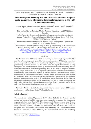
International Journal of Safety ScienceVol. 02, No. 01, (2018), pp. 74-83DOI:10.24900/ijss/02017483.2018.0301Special Issue Article: The 5th European STAMP Workshop (ESW) 2017, Chief Editor:Svana Helen Björnsdottir, Reykjavik UniversityMaritime Spatial Planning as a tool for ecosystem-based adaptivesafety management of maritime transportation system in the Gulfof Finland (Baltic Sea)Robert Aps*1, Mihhail Fetissov2, Floris Goerlandt3, Pentti Kujala3, Are Piel4,John Thomas51University of Tartu, Estonian Marine Institute, Mäealuse 14, 12618 Tallinn,Estonia2Aalto University, School of Engineering, Department of Applied Mechanics,Marine Technology, Research Group on Maritime risk and Safety, P.O. Box12200, FI00076 Espoo, Finland3Estonian Maritime Administration, Vessel Traffic Management Department,Valge 3, 11413 Tallinn, Estonia4Massachusetts Institute of Technology, School of Engineering, 77 MassachusettsAvenue, Building E40-242, Cambridge, Massachusetts 02139-4307, USA*1robert.aps@ut.ee, 1mihhail.fetissov@ut.ee, , 3 Are.Piel@vta.ee, 4jthomas4@mit.eduAbstractThe Maritime Spatial Planning (MSP) is becoming an increasingly important tool foradaptive safety management of maritime transportation system (MTS) being ecosystembased, integrated, place-based or area-based, adaptive, strategic, anticipatory andparticipatory iterative process. At the same time the rapid developments in shipintelligence are transforming the future of marine operations and are adding the newcomplexity to adaptive safety management of MTS. In this study in progress the ships’routing design is considered to be an important safety-critical element of ecosystem-basedtransboundary MSP solutions in the Gulf of Finland sea area. The STPA hazard analysismethodology is applied to identify ships’ routing design related system level hazards,corresponding safety constraints and the potentially unsafe control actions that may leadto ships’ routing hazardous design. To avoid ships’ routing hazardous design flaws theimplementation of safety-guided design is suggested with aim to embed the cost-effectivesafety effort into the ships’ routing design process from the very beginning and to designsafety into the system as the design decisions are made.Keywords: Maritime Spatial Planning, maritime transportation system, STPA, ships’routing, safety-guided design, Gulf of Finland, Baltic Sea1. IntroductionThe International Maritime Organization (IMO) defines the Baltic Sea Area as a globallyunique and sensitive brackish-water ecosystem vulnerable to damage by internationalshipping activities - more than 2,000 ships are en route in the area on an average day, notincluding ferries, smaller fishing vessels or leisure craft [1]. Being aware of its ecological,social, economic, cultural, scientific and educational value the Baltic Sea Area wasdesignated as a Particularly Sensitive Sea Area (PSSA) by IMO Marine EnvironmentProtection Committee in 2005. Addressing the environmental concerns the Mandatory*Corresponding author robert.aps@ut.ee74
International Journal of Safety ScienceVol. 02, No. 01, (2018), pp. 74-83DOI:10.24900/ijss/02017483.2018.0301Ship Reporting System in the Gulf of Finland Traffic Area (GOFREP) was established byIMO [2, 3] in 2003 and has been in effective operation since 2004 [4].The basic tenet of an ecosystem-based approach is that conserving ecosystem functionsand integrity is vital because viable ecosystems are the basic life support system forhuman communities [5]. HELCOM Guideline for the implementation of ecosystem-basedapproach in Maritime Spatial Planning (MSP) in the Baltic Sea area [6] defines theecosystem approach as “the comprehensive integrated management of human activitiesbased on the best available scientific knowledge about the ecosystem and its dynamics, inorder to identify and take action on influences which are critical to the health of marineecosystems, thereby achieving sustainable use of ecosystem goods and services andmaintenance of ecosystem integrity”.The EU Directive establishing a framework for maritime spatial planning [7] definesobjectives of maritime spatial planning (MSP) as follows “When establishing andimplementing maritime spatial planning, Member States shall consider economic, socialand environmental aspects to support sustainable development and growth in the maritimesector, applying an ecosystem-based approach, and to promote the coexistence of relevantactivities and uses. Through their maritime spatial plans, Member States shall aim tocontribute to the sustainable development of energy sectors at sea, of maritime transport,and of the fisheries and aquaculture sectors, and to the preservation, protection andimprovement of the environment, including resilience to climate change impacts”.According to IMO General Provisions on Ships’ Routing (GPSR) [8] the purpose of ships'routing is to improve the safety of navigation in converging areas and in areas where thedensity of traffic is great or where freedom of movement of shipping is inhibited byrestricted sea-room, the existence of obstructions to navigation, limited depths orunfavorable meteorological conditions and the routing system is defined as any system ofone or more routes or routing measures aimed at reducing the risk of casualties includingthe traffic separation schemes, two-way routes, recommended tracks, areas to be avoided,inshore traffic zones, roundabouts, precautionary areas and deep water routes.A System Theoretic Accident Modelling and Processes (STAMP) approach to operationalsafety management, originally developed for software and space engineering applications[9], considers accident occurrence as the result of a lack of, or inadequate enforcement of,constraints imposed on the system design and operations at various system levels. Thisnovel to maritime domain approach is used to outline STAMP based dynamic safetymanagement of eco-socio-technical maritime transport system [10] and STAMP-Marbased safety management of maritime navigation in the Gulf of Finland [11]. TheSTAMP based Systems Theoretic Process Analysis (STPA) [9, 12] as a powerful newhazard analysis method designed to go beyond traditional safety techniques has beensuccessfully applied e.g. to space engineering applications [13] as well as to analysis ofmaritime traffic safety in the Gulf of Finland [14].In this study in progress the ships’ routing design is considered to be an important safetycritical element of ecosystem-based transboundary MSP solutions in the Gulf of Finlandsea area. The STPA hazard analysis methodology is applied to identify ships’ routingdesign related system level hazards, corresponding safety constraints and the potentiallyunsafe control actions that may lead to ships’ routing hazardous design. The ships’routing design not meeting the IMO GPSR safety requirements is identified as the systemlevel hazard and the IMO GPSR design criteria are considered to be the system safetyconstraints to be imposed on the ships’ routing design.2. Mandatory ship reporting system in the Gulf of Finland (GOFREP)75
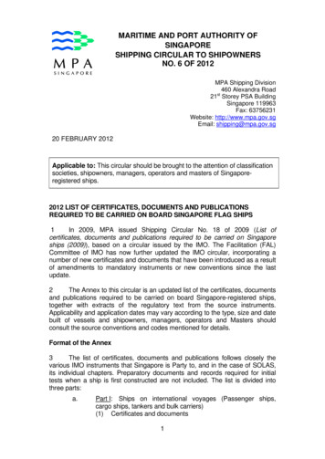
International Journal of Safety ScienceVol. 02, No. 01, (2018), pp. 74-83DOI:10.24900/ijss/02017483.2018.0301Referring to IMO [2] “The mandatory ship reporting system in the Gulf of Finland coversthe international waters in the Gulf of Finland. In addition, Estonia and Finland haveimplemented mandatory ship reporting systems to their national water areas outside VTSareas. These reporting systems provide same services and make same requirements toshipping as the system operating in the international waters. The mandatory ship reportingsystem and the Estonian and Finnish national mandatory ship reporting systems aretogether referred as the GOFREP and their area of coverage respectively as the GOFREParea” (Figure 1).Figure 1. The mandatory ship reporting system in the Gulf of Finland(source: Estonian Maritime Administration)According to IMO [3] ships of 300 gross tonnage and over are required to participate inthe GOFREP system while ships under 300 gross tonnage should make reports incircumstances where they 1) are not under command or at anchor in the TrafficSeparation Scheme (TSS), 2) are restricted in their ability to maneuver, and 3) havedefective navigational aids.The GOFREP maritime traffic control system is jointly managed by the Finnish TransportAgency, Estonian Maritime Administration and the Federal Agency for Maritime andRiver Transport of Russian Federation and is based on the activities of GOFREP TrafficCenters of Estonia (Tallinn Traffic), Finland (Helsinki Traffic) and the RussianFederation VTMIS Centre in Petrodvorets (Saint Petersburg Traffic).The GOFREP Traffic Centre operator is able to observe the controlled maritime trafficprocess through the radar and AIS surveillance of traffic in the Ship Reporting System(SRS) area, and to actuate the process if the vessels under control proceed againstInternational Regulations for Preventing Collisions at Sea, 1972 as amended (COLREGS).3. IMO General Provisions on Ships’ Routing76
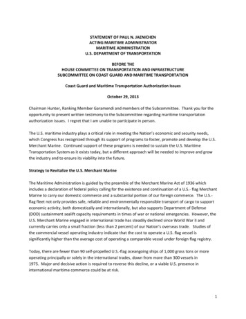
International Journal of Safety ScienceVol. 02, No. 01, (2018), pp. 74-83DOI:10.24900/ijss/02017483.2018.0301The main objectives of the ships’ routing systems as defined by IMO [15] are: “1) theseparation of opposing streams of traffic so as to reduce the incidence of head-onencounters, 2) the reduction of dangers of collision between crossing traffic and shippingin established traffic lanes, 3) the simplification of the patterns of traffic flow inconverging areas, 4) the organization of safe traffic flow in areas of concentrated offshoreexploration or exploitation, 5) the organization of traffic flow in or around areas wherenavigation by all ships or by certain classes of ship is dangerous or undesirable, 6) theorganization of safe traffic flow in or around or at a safe distance from environmentallysensitive areas, 7) the reduction of risk of grounding by providing special guidance tovessels in areas where water depths are uncertain or critical, and 8) the guidance of trafficclear of fishing grounds or the organization of traffic through fishing grounds”.It is generally recognized that the Baltic Sea offers a wealth of resources that can besustainably utilized to harvest energy while ensuring that energy interests can coexist withother spheres of activity. The offshore energy production is considered to be one of themain drivers of MSP in the Baltic Sea Region. According to IMO [16] in planning toestablish multiple structures at sea, including but not limited to wind turbines“Governments should take into account, as far as practicable, the impact these could haveon the safety of navigation, including any radar interference. Traffic density andprognoses, the presence or establishment of routeing measures in the area, and themanoeuvrability of ships and their obligations under the 1972 Collision Regulationsshould be considered when planning to establish multiple structures at sea. Sufficientmanoeuvring space extending beyond the side borders of traffic separation schemesshould be provided to allow evasive manoeuvres and contingency planning by shipsmaking use of routeing measures in the vicinity of multiple structure areas”.The IMO Maritime Safety Committee, with a view to ensuring the proper development,drafting, and submission of proposals for ships’ routing systems and ship reportingsystems, approved a Guidance Note on the Preparation of Proposals on Ships’ RoutingSystems and Ship Reporting Systems [17]. Referring to proposals intended to protect themarine environment, the proposal should state whether the proposed routing system canreasonably be expected to significantly prevent or reduce the risk of pollution or otherdamage to the marine environment of the area concerned.Several ships’ routing measures are established in the GOFREP sea area (Figure 2):1) Deep-water route - a route within defined limits which has been accurately surveyedfor clearance of sea bottom and submerged obstacles as indicated on the chart,2) Traffic separation scheme - a routing measure aimed at the separation of opposingstreams of traffic by appropriate means and by the establishment of traffic lanes,3) Traffic separation zone or line - a zone or line separating the traffic lanes in whichships are proceeding in opposite or nearly opposite directions; or separating a traffic lanefrom the adjacent sea area; or separating traffic lanes designated for particular classes ofship proceeding in the same direction,4) Traffic lane - an area within defined limits in which one-way traffic is established;natural obstacles, including those forming separation zones, may constitute a boundary,5) Roundabout - a routing measure comprising a separation point or circular separationzone and a circular traffic lane within defined limits; traffic within the roundabout isseparated by moving in a counter clockwise direction around the separation point or zone,6) Precautionary area - a routing measure comprising an area within defined limits whereships must navigate with particular caution and within which the direction of traffic flowmay be recommended.77
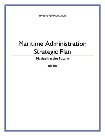
International Journal of Safety ScienceVol. 02, No. 01, (2018), pp. 74-83DOI:10.24900/ijss/02017483.2018.0301Figure 2. Ships’ routing measures established in the GOFREP sea area(source: HELCOM g to IMO [15] the routing system selected for a particular area should aim atproviding safe passage for ships through the area without unduly restricting legitimaterights and practices, and taking account of anticipated or existing navigational hazards. Itis stated further that when planning, establishing, reviewing or adjusting a routing system,the following factors shall be taken into account: 1) the rights and practices in respect ofthe exploitation of living and mineral resources, 2) previously established routing systemsin adjacent waters, whether or not under the proposing Government’s jurisdiction, 3) theexisting traffic pattern in the area concerned, including coastal traffic, crossing traffic,naval exercise areas and anchorage areas, 4) foreseeable changes in the traffic patternresulting from port or offshore terminal developments, 5) the presence of fishing grounds,6) existing activities and foreseeable developments of offshore exploration or exploitationof the sea-bed and subsoil, 7) the adequacy of existing aids to navigation, hydrographicsurveys and nautical charts of the area, 8) environmental factors, including prevailingweather conditions, tidal streams and currents and the possibility of ice concentrations,and 9) the existence of environmental conservation areas and foreseeable developments inthe establishment of such areas.4. STPA hazard analysisIn this study the STPA hazard analysis is performed on the STAMP-Mar functionalcontrol diagram of the ships’ routing design processes (Figure 3). In a course of STPAhazard analysis applied to the ships’ routing design processes the accident is specified asan undesired and unplanned environmental and socio-economic loss event (e.g. ships’collision or running aground) caused by actual application of the ships’ routing hazardousdesign. Ships’ routing design not meeting the IMO GPSR safety requirements isidentified as the system-level hazard and the IMO GPSR design criteria are considered tobe the system safety constraints to be imposed on the ships’ routing design.78
International Journal of Safety ScienceVol. 02, No. 01, (2018), pp. 74-83DOI:10.24900/ijss/02017483.2018.0301Ships’ routing actual design starts after the hazards and system-level safety requirementsand constraints have been identified and it is carried out according to rules [16] ondevelopment, drafting, and submission of proposals to IMO for ships’ routeing systemssetting forth the issues that should be included in such proposals to facilitate theirassessment and approval by the Sub-Committee on Safety of Navigation (NAV) and finaladoption by the Maritime Safety Committee (MSC). It is further added that whendeveloping a proposal, the IMO Member Governments should in particular consult theGPSR for the definition of the type of system desired, the method for establishing thatparticular type of system, and, if the system is a traffic separation scheme or a deep-waterroute, including the specific information pertaining to those types of systems.Figure 3. STAMP-Mar functional control diagram of the ships’ routingsafety-guided design processes (modified from [9])The mainstream use of unmanned, remote-controlled or autonomous vessels may verywell be the future of commercial shipping [18]. This technological advancement is addingthe new requirements to maritime transportation safety management including theamendment of existing and development of new ships’ routing measures being ecosystembased and meeting also the requirements of unmanned shipping operations. These are theexternal factors shown in the Figure 3.The prototypes of unmanned merchant vessels are expected to come into service withinthe coming years and the introduction of the unmanned merchant vessels to the global79
International Journal of Safety ScienceVol. 02, No. 01, (2018), pp. 74-83DOI:10.24900/ijss/02017483.2018.0301shipping industry appears to be only a matter of time, despite all social, legal andtechnological concerns [19]. It is suggested [20] that the implications of suchtechnological advances are enormous and will require an amendment to the existing legalstructures and regulations, perhaps paving way for a new regulatory regime to deal withliabilities.Referring to [18] also existing conventions and laws that apply to commercial shippingcan be adapted as needed and it is added that “ biggest adaptations would beconsidering a qualified remote crew the equivalent of a properly manned ship, a remoteoperator as the master of the ship, and the electronic sensor systems as their eyes andears”.It is stated [19] that from the scarce body of literature in the field of unmanned shipping itis evident that one of major issues related to the unmanned ship operations is their safetywhile the main line of argument supporting their introduction pertains to the increase innavigational safety. Therefore, the development and implementation of the safe ships’routing design seems to be even more important in connection to navigational safety ofemerging unmanned ship operations.The ships’ routing design related system-level hazards and safety constraints to beenforced are presented in Table 1.Table 1. Ships’ routing design related system level hazards and the safetyconstraints according to IMO General Provisions on Ships’ Routing – GPSR(1985, as amended)System level hazards relatedto ships’ routing designShips’ routing design ofcourse alterations along theroute is not meeting the IMOGPSR requirementsShips’ routing design of trafficseparation schemes is notmeeting the IMO GPSRrequirementsShips’ routing design ofmaritime traffic lanes is notmeeting the IMO GPSRrequirementsShips’ routing design to allowoptimum use of aids tonavigation in the area is notmeeting the IMO GPSRrequirementsShips’ routing design related safety constraintsaccording to IMO General Provisions on Ships’Routing – GPSR 1985, as amended)Course alterations along a route should be as few aspossible and should be avoided in the approaches toconvergence areas and route junctions or wherecrossing traffic may be expected to be heavyTraffic separation schemes shall be designed so as toenable ships using them to fully comply at all timeswith the International Regulations for PreventingCollisions at Sea (COLREGs), 1972, as amendedTraffic lanes should be designed to make optimum useof available depths of water and the safe navigableareas, taking into account the maximum depth ofwater attainable along the length of the route. Thewidth of lanes should take account of the trafficdensity, the general usage of the area and the sea-roomavailableRoutes should be designed to allow optimum use ofaids to navigation in the area, and of such shipbornenavigational aids as are required or recommended tobe fitted by international conventions or by IMOresolutions and recommendationsAs the first step of STPA, the potentially unsafe control actions that may lead to the ship’srouting hazardous design are identified and presented in Table 2.80
International Journal of Safety ScienceVol. 02, No. 01, (2018), pp. 74-83DOI:10.24900/ijss/02017483.2018.0301Table 2. Potentially unsafe control actions that may lead to the ship’srouting hazardous designControl actionrequiredAction required butnot providedAction providedunsafeAction provided toolateImpose ships’routing safetyconstraints on designof course alterationsalong the routeaccording to IMOGPSRHazardous design –ships’ routing safetyconstraints on designof course alterationsalong the routeaccording to IMOGPSR are notimposedHazardous design –ships’ routing safetyconstraints on designof traffic separationschemes according toIMO GPSR are notimposedHazardous design –ships’ routing safetyconstraints on designof course alterationsalong the routeaccording to IMOGPSR are notproperly imposedHazardous design –ships’ routing safetyconstraints on designof traffic separationschemes accordingto IMO GPSR arenot properlyimposedHazardous design –ships’ routing safetyconstraints on designof maritime trafficlanes according toIMO GPSR are notproperly imposedHazardous design –ships’ routing safetyconstraints on designto allow optimumuse of aids tonavigation in thearea according toIMO GPSR are notproperly imposedHazardous design –ships’ routing safetyconstraints on designof course alterationsalong the routeaccording to IMOGPSR are not timelyimposedHazardous design –ships’ routing safetyconstraints on designof traffic separationschemes according toIMO GPSR are nottimely imposedImpose ships’routing safetyconstraints on designof traffic separationschemes accordingto IMO GPSRImpose ships’routing safetyconstraints on designof maritime trafficlanes according toIMO GPSRImpose ships’routing safetyconstraints on designto allow optimumuse of aids tonavigation in thearea according toIMO GPSRHazardous design –ships’ routing safetyconstraints on designof maritime trafficlanes according toIMO GPSR are notimposedHazardous design –ships’ routing safetyconstraints on designto allow optimum useof aids to navigationin the area accordingto IMO GPSR are notimposedHazardous design –ships’ routing safetyconstraints on designof maritime trafficlanes according toIMO GPSR are nottimely imposedHazardous design –ships’ routing safetyconstraints on designto allow optimum useof aids to navigation inthe area according toIMO GPSR are nottimely imposedThe second step of STPA hazard analysis is performed on a STAMP-Mar functionalcontrol diagram of the ships’ routing design processes (Figure 3) with aim to identify thecausal factors for potentially hazardous control actions based on expert interviews anddiscussions. It was suggested by experts that without systems approach the hazardanalysis may sometimes be performed after the major design decisions on ships’ routingdesign have been done and as a consequence not all potential and hidden hazards areidentified and designed out of the system.With aim to avoid ships’ routing hazardous design flaws the implementation of safetyguided design is suggested with aim to embed the cost-effective safety effort into theships’ routing design process from the very beginning and to design safety into the systemas the design decisions are made. Therefore it is suggested to use STPA in a proactiveway guiding the ships’ routing design by integrating the design and hazard analysis intothe safety-guided design processes.Referring to [21] the MSP is becoming an increasingly important tool for adaptive safetymanagement of maritime transportation being ecosystem-based, integrated, place-based orarea-based, adaptive, strategic, anticipatory and participatory iterative process. Thereby81
International Journal of Safety ScienceVol. 02, No. 01, (2018), pp. 74-83DOI:10.24900/ijss/02017483.2018.0301the objective is to integrate the issues that are most vital to maritime transportation safety, continued operation, business success and efficiency of sustainable maritimetransportation system into the MSP options. At that the practical implementation of theSTAMP concept enables planners and the stakeholders to integrate the monitoring andevaluation functions directly into the actual maritime spatial planning processes [10].It is stated [22] that the MSP process should result in a plan that lead to organizing andregulating the human uses of the seas while protecting marine ecosystems and deliver theecosystem services and societal benefits. The Ten tenets of Elliott are suggested as thequality objectives of the plan (QOP) reflecting what the MSP process should achieve [23].Based on that the integrated and holistic planning solutions should be: 1)environmentally/ecologically sustainable, 2) technologically feasible, 3) economicallyviable, 4) socially desirable/tolerable, 5) legally permissible, 6) administrativelyachievable, 7) politically expedient, 8) ethically defensible, 9) culturally inclusive, and 10)effectively communicable.Based on this study it is suggested to use STPA in a proactive way guiding the maritimespatial planning processes including the ships’ routing design by integrating the planningoptions hazard analysis into the safety-guided MSP development. It is further suggested touse the Ten tenets of Elliott for integrated, successful and sustainable maritimemanagement as the safety constraints to be satisfied in a course of ecosystem baseddevelopment and implementation of the integrated transboundary maritime planningsolutions in terms of environment, legislation, policies, governance, cultural, social,economic, and technological considerations.9. ConclusionsAs defined by IMO the purpose of ships' routing is to improve the safety of navigation inconverging areas and in areas where the density of traffic is great or where freedom ofmovement of shipping is inhibited by restricted sea-room, the existence of obstructions tonavigation, limited depths or unfavorable meteorological conditions.The STPA hazard analysis methodology is applied to identify ships’ routing designrelated system level hazards, corresponding safety constraints and the potentially unsafecontrol actions that may lead to ships’ routing hazardous design.To avoid ships’ routing hazardous design flaws the implementation of safety-guideddesign is suggested with aim to embed the cost-effective safety effort into the ships’routing design process from the very beginning and to design safety into the system as thedesign decisions are made. Therefore it is suggested to use STPA in a proactive wayguiding the ships’ routing design by integrating the design and hazard analysis into thesafety guided design processes.It is suggested to use STPA in a proactive way guiding the maritime spatial planningprocesses including the ships’ routing design by integrating the planning options hazardanalysis into the safety-guided MSP development. It is further suggested to use the Tentenets of Elliott for integrated, successful and sustainable maritime management as thesafety constraints to be satisfied in a course of ecosystem based development andimplementation of the integrated transboundary maritime planning solutions.Acknowledgments82
International Journal of Safety ScienceVol. 02, No. 01, (2018), pp. 74-83DOI:10.24900/ijss/02017483.2018.0301This work resulted from the BONUS project “Strategic and operational risk managementfor wintertime maritime transportation system (BONUS STORMWINDS)". The projectwas supported by BONUS (Art 185), funded jointly by the EU and the national fundinginstitutions: the Academy of Finland (Finland), the Estonian Research Council (Estonia),the Research Council for Environment Agricultural Sciences and Spatial Planning(FORMAS) (Sweden).References[1]IMO, Designation of the Baltic Sea area as a particularly sensitive sea area. Resolution MEPC.136 (53),(2005).[2]IMO, Mandatory Ship Reporting Systems SN.1/Circ.258, International Maritime Organization, London,(2006).[3]IMO, Mandatory Ship Reporting Systems SN/Circ.225, International Maritime Organization, London,(2003).[4]S. Sonninen, M. Nuutinen, T. Rosqvist, Development process of the Gulf of Finland mandatory shipreporting system - reflections on the methods, VTT Publications 614, Espoo, (2006), 124 p.[5]S. Leech, A. Wiensczyk, J. Turner, “Ecosystem management: A practitioners’ guide”, BC Journal ofEcosystems and Management, vol. 10, no. 2 (2009), pp. 1–12.[6]HELCOM, Guideline for the implementation of ecosystem-based approach in Maritime Spatial Planning(MSP) in the Baltic Sea area, (2016).[7]EC, Directive 2008/56/EC of the European Parliament and of the Council of 17 June 2008 establishing aframework for community action in the field of marine environmental policy (Marine StrategyFramework Directive) (2008).[8]IMO, General provisions on ships’ routing, Res. A.572 (14), (1985).[9]N. Leveson, Engineering a safer world - Systems theory applied to safety. Cambridge, MA, MIT Press,(2011).[10] R. Aps, M. Fetissov, F. Goerlandt, J. Helferich, M. Kopti, P. Kujala, Towards STAMP based dynamicsafety management of eco-sociotechnical maritime transport system, Procedia Engineering, 128, (2015),pp. 64 – 73.[11] R. Aps, M. Fetissov, F. Goerlandt, M. Kopti, P. Kujala, STAMP-Mar based safety management ofmaritime navigation in the Gulf of Finland (Baltic Sea), European Navigation Conference 2016,Helsinki, 30 May-2 June 2016, IEEE Xplore, (2016), pp. 1 8.[12] J.P. Thomas, Extending and Automating a Systems-Theoretic Hazard Analysis for RequirementsGeneration and Analysis, Sandia Report SAND2012-4080, Sandia National Laboratories, (2012).[13] T. Ishimatsu, N. Leveson, J. Thomas, C. Fleming,
Maritime Spatial Planning as a tool for ecosystem-based adaptive . Mandatory ship reporting system in the Gulf of Finland (GOFREP) International Journal of Safety Science Vol. 02, No. 01, (2018), pp. 74-83 . and to actuate the process if the vessels under control proceed against International Regulations for Preventing Collisions at Sea .