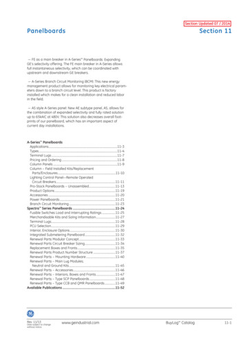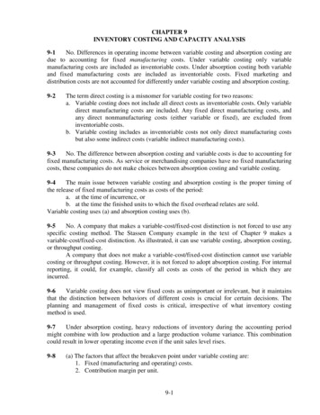
Transcription
SECTION II - INVENTORY AND ANALYSISA.INTRODUCTION1.LocationThe Town of Southold is located at the eastern extreme of Long Island, at the end of the northernpeninsula known as the North Fork. It is the eastern-most township on the North Fork and isbordered to the west by the Town of Riverhead and to the south by the Town of Shelter Island.The incorporated Village of Greenport lies within the Town of Southold. The regional setting ofSouthold is illustrated on Map II-1. The entire Town, including Fishers, Plum and Robins islands,is approximately 54 square miles in size with approximately 163 linear miles of coastline. It islong and narrow in shape, with the mainland extending 21 miles from the Riverhead town line eastto Orient Point. Its greatest width is 5 miles, although generally the western portions of themainland average 3 miles in width, while to the east of Hashamomuck Pond, the Town is neverwider than 1.25 miles.The land in mainland Southold is for the most part level or gently sloping. The major exception isthe Long Island Sound shoreline, which is characterized by steep bluffs and backed by woodedhills, which give way to land that gently slopes to the marshes and wetlands of the Peconic Estuaryshoreline to the south. The Sound shoreline features scattered residential development, while thecreeks, inlets and ponds of the Peconic Estuary shoreline, are more intensely developed. Theinterior portions of the mainland are typically in agricultural use with scattered woodland pocketson the less productive soils, residential enclaves and the hamlet centers.Fishers Island’s terrain is slightly more rugged that that of the mainland. Almost none of its land isin agricultural use. Large residential estate, golf courses and open spaces dominate the landscapeof more than two thirds of the island. The western portion of the island, which was the site of aformer military base, is more intensively developed with a small airport, a school, severalbusinesses and smaller residential lots.The Town is surrounded by the marine waters of the Long Island Sound, Fishers Island Sound,Block Island Sound, Gardiners Bay, and the bays of the Peconic Estuary. There are five islandslocated within the municipal jurisdiction of the Town. Fishers Island (approximately 3200 acres)is located 13 miles northeast of the mainland of Southold and 3 miles south of the Connecticutcoastline on Fishers Island Sound. Plum Island and the Gull Islands are owned by the Federalgovernment. Plum Island (847 acres), located 0.5 miles east of Orient Point, is utilized forgovernment research and access is restricted. Great Gull Island (25 acres) and Little Gull Island (5acres) are uninhabited islands serving primarily as bird nesting refuges. They are located betweenPlum Island and Fishers Island. Robins Island (435 acres), presently a largely undeveloped islandin private ownership, lies approximately 1.25 miles southwest of Little Hog Neck, in the GreatPeconic Bay.The Town of Southold developed as a series of discrete traditional hamlets separated by expansesof agricultural land. These hamlets include Laurel, Mattituck, Cutchogue, New Suffolk, Peconic,Southold, East Marion and Orient. There is also a small hamlet on Fishers Island. These hamletsare the main centers of residential development and commercial activity within the Town ofSouthold and form the community framework of the Town with which its residents identify. Theimportance of the historical development of the hamlets and their crucial role in the currentdevelopment patterns within the Town are a recurring theme throughout the LWRP.Section I I A - 1
2.TransportationThe Town has a well established network of public roads including 195 miles of Town highways,14 miles of County highways, and 24 miles of State highways. (Source: New York StateDepartment of Transportation, Region 10, Division of Planning & Program Management. April1997). Two major arterials run west to east. NY Route 25 extends throughout the southern andcentral portions of the Town and County Route 48 extends throughout the northern and centralportions of the Town. The State road is a two lane highway, with designated turning lanes in theMattituck and Cutchogue business areas. For much of its length, SR 25 follows an historic routedating back to the 1700s that was known as The King’s Highway. The road ran from Brooklyn toOrient Point.The County road (CR 48) is a four lane divided highway beginning at Mattituck and ending justwest of Horton Lane in Southold. East and west of CR 48, the town and state connectors are twolane highways. The County road was built in the 1960s presumably in anticipation of theextension of the Long Island Expressway from its current terminus in Riverhead. The roadbranches off Old Sound Avenue and bypasses the hamlet business centers in a route that parallelsthe Long Island Rail Road track to the south, which runs along the spine of the North Fork to itsterminus in Greenport Village.The remainder of the collector roads within the Town tend to run in a north-south direction,providing direct access between Long Island Sound and the Peconic Bay. Many of the roads thatrun to the water’s edge originally connected shipping piers and docks with hamlet business centersor farms. Others connected farms directly to business centers, including grist mills, most of whichwere water powered.The cycling craze (1890s through 1910) led to a number of road improvements within SoutholdTown, which eventually came to benefit automotive forms of transport. The Town anticipates thatit will need to engage in transportation planning within the very near future in order to preventexisting traffic congestion and speeding problems from worsening, particularly within the hamletcenters. One of the challenges the Town faces will be maximizing its transportation capabilitygiven the limitations of the existing road network and its desire not to create major new arterials,nor to add travel lanes to the existing arterials.The Long Island Rail Road runs along Southold’s spine, terminating on the waterfront in theIncorporated Village of Greenport. This single, mainline track runs to Ronkonkoma, where itmeets an electrified rail line to New York City. Between the hamlets of Southold and the Village ofGreenport, the rail line traverses tidal and brackish water wetlands and Hashamomuck Pond, all ofwhich lie within the coastal boundary. Otherwise it generally runs along higher ground in thecenter of the fork.There are stations within the business districts of the hamlets of Mattituck and Southold also.When the rail line was first built in the 1840s, there was an additional station at Cutchogue and amail drop and station at Peconic. Unfortunately, the latter two stations no longer exist and are notlikely to be reinstated. Average commuter time from Greenport to Penn Station in New York Cityis just under three hours. However, service is limited, particularly during the winter months whenthere are two daily trains westbound from Greenport during the week. The weekend schedule islimited to two afternoon trains westbound. Eastbound only two trains per weekday run all the wayto Greenport, one in the early morning, the other in the evening, with the exception of Friday nightwhen there is an extra evening run. There are two weekday runs eastbound in the mid-day andSection I I A - 2
early evening. During the summer there may be additional trains, particularly on key weekendswhen major events are being promoted within the Town. The LIRR sometimes offers specialexcursion rates and hotel package deals during these weekends in coordination with representativesof the business community such as the North Fork Promotion Council and the East End MaritimeFestival organizers.The Long Island Rail Road’s primary focus is on providing heavy commuter transit fromRonkonkoma west into Manhattan. The population density and ridership levels on the East Endare considered insufficient to justify improved commuter service to western Long Island orManhattan. That need is being met presently by a private bus service.Public and private bus services are available within Southold Town. Public bus service has beenreduced to one route, the S92, which runs from Orient Point to East Hampton through downtownRiverhead (Suffolk County Transit, November 19, 2001). Although this service runs seven days aweek, it is limited to daytime and early evening operation, 6:15 a.m. to 7:40 p.m. Its ridership iscomposed of working people, elderly and youth, in that order. Feeder runs from Mattituck andNew Suffolk were dropped due to extremely low ridership patterns. This bus service is sponsoredby Suffolk County but is heavily subsidized by federal funds. A local bus company, SunriseCoach Lines, provides the service under contract to the County.The Sunrise Coach Line also offers a daily commuter service from Greenport to Manhattan andback with three to five departure times per day. The company provides excursion tours into andout of the region. Sunrise Coach is the primary public transit option for Southold residents whowish to go into New York City.There is no bus service (public or private) to the LIRR station in Ronkonkoma, which has morefrequent runs into Jamaica, Queens and Penn Station. Nor is there any bus service (public orprivate) to MacArthur Airport in Islip just adjacent to the LIRR Rail Road station. Groundtransportation to and from the airport is available from private limousine and taxi companies.The Town of Southold is serviced by four different ferry companies. The largest, Cross SoundFerry Service, Inc. offers year-round passenger and car ferry service from Orient Point (Reach 5)to New London, Connecticut. In July 1995, this company established a high speed passenger ferryservice between Orient Point and New London. The 350-passenger ferry travels at 30 knots, whichcuts the crossing time from 90 to 40 minutes. The establishment of this high speed ferry service hashad an effect on highway use and transportation patterns within the Town of Southold. Theintroduction of the high speed service triggered litigation whereby the Town is being sued by acitizens’ group for failure to prevent, or at the least control, the increased level of ferry service. Inaddition, the Cross Sound Ferry Co. has sued the Town in an attempt to prevent it from exertingcontrol over the ferry operation.In recognition of the increasing traffic congestion and the need to mitigate it, the Town isundertaking several initiatives which are described in Section II.B. Planning Framework underSubsection 9, Town of Southold Transportation Committee.The Plum Island Ferry is run by the U.S. Department of Agriculture and it serves only those peopleemployed on Plum Island. The North Ferry Company, a privately-held outfit owned by the ShelterIsland Heights Property Owners Association, offers year-round ferry service between the Villageof Greenport and Shelter Island. The Fishers Island Ferry Company, a quasi-public outfit ownedSection I I A - 3
and operated by the Fishers Island Ferry District, provides a year-round ferry service for bothpassengers and vehicles between New London, Connecticut and Fishers Island (Reach 10). Theseferry services are discussed in more detail in their respective Reach Analysis.There are the three airport facilities located in the Town of Southold, although none of these offerscheduled commercial flights. The Charles Rose Air Field (Reach 4) and Mattituck Airbase(Reach 9) are privately owned. Charles Rose is a grass field, which sees limited use by lightaircraft.Mattituck Airbase hosts a single north-south asphalt runway and several hangars. Only smallerlight planes such as Cessna, Piper Cub and Beechcraft can use this facility due to the shortness ofthe runway. One of the Town’s largest employers, the Mattituck Aviation Corporation operates outof Mattituck Airbase. This company is considered one of the premier light engine overhaulfacilities on the East Coast.Elizabeth Field on Fishers Island (Reach 10), is the largest and best aviation facility within theTown. It was originally owned by the U.S. government. Today it is owned by the Town but isoperated by the Fishers Island Ferry District. It is located on a 178 acre parcel that was originallypart of the U.S. Army's Fort Wright. The airport has a 2,500 foot paved runway, which ismaintained with funds from the Federal Aviation Authority. Air taxi services account forapproximately 50% of the aircraft traffic.3.Geology and topographyLong Island owes its origin to a succession of two glacial advances and retreats that occurred overeleven thousand years ago during the Wisconsin stage of the Pleistocene Epoch. The Island wasshaped by the accumulation and deposition of materials originally from the north and transportedsouth with each glacial advance. As the glaciers began to recede and melt, their accumulatedmaterial was deposited along the line of farthest advancement, forming ridge-like featurescommonly referred to as moraines. In addition, as the glacial ice melted, streams formed andcarried lightweight material away from the moraine, thus establishing the glacial outwash plain.Southold's landscape is a product of the second major advance of the Wisconsin Glacier. Thesecond advance terminated along the north shore, depositing the Harbor Hill Moraine and creatingthe pronounced bluffs, which span the Town's entire northern coastline. The morainal depositsconsist of stratified sands and gravels and associated till. The till ranges from about 5 to 50 feet inthickness and contains many boulders. Gaps along the morainal ridgeline, occupied now byMattituck Creek, Hashamomuck Pond, Dam Pond and Plum Gut represent areas where blocks ofglacial ice were partially buried and then melted after the retreat of the main ice front (Crandell,USGS, 1963).Following the second advance, the glacial ice melt carried sediments south, establishing theoutwash plain that makes up the interi
That need is being met presently by a private bus service. Public and private bus services are available within Southold Town. Public bus service has been reduced to one route, the S92, which runs from Orient Point to East Hampton through downtown Riverhead (Suffolk County Transit, November 19, 2001). Although this service runs seven days a week, it is limited to daytime and early evening .