Transcription
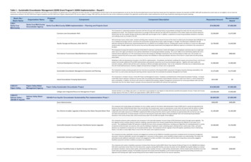
Table 1 – Sustainable Groundwater Management (SGM) Grant Program’s SGMA Implementation – Round 1Disclaimer: The Recommended Award are conditional until final terms and conditions are agreed upon and an agreement has been executed. The awarded grant amount listed in the executed agreement can be less than the Recommended Award amount listed here based upon final negotiations between the Awardee and DWR. DWR staff may determine certain tasks are not eligible or do not meet therequirements outlined in the 2021 SGM Grant Program Guidelines and 2021 SGM Grant Program Implementation PSP and are subject to change. DWR staff may also determine that certain components provided in the application would be better suited combined into one for ease of quarterly reporting and closeout reporting.Basin No./Basin Name3-001/Santa CruzMid-County3-002.01/Pajaro ValleyOrganization NameProposalTitleRequested AmountRecommendedAward 10,090,000 7,600,000Cunnison Lane Groundwater WellThis Component is a planned groundwater extraction well that will assist with reducing reliance on groundwater pumping from wells near the coast and increasepumping more inland. This Component would extract an average of 426 acre-feet per year (afy) with the operations of Pure Water Soquel and could be reduced to329 afy when the City’s Aquifer Storage and Recovery (ASR) wells were brought on-line. In addition, is expected to increase the groundwater elevations in the Basinand modeling results are included in the GSP. 2,500,000 1,675,000Aquifer Storage and Recovery, Beltz Well 10ASR would inject excess surface water, treated to drinking water standards, into the natural structure of the Santa Cruz Mid County Groundwater Basin (MCGB) for useas an underground storage reservoir, and extract this stored water during periods of water supply shortages, or drought. The ASR project modeled for the GSPoptimizes existing City infrastructure, demonstrating that this as an efficient use of available resources. Drinking water stored in the Basin as a result of an ASR projectwould provide a drought supply for the City service area and any ASR project would need to be designed with additional capacity to contribute to the restoration ofthe Basin. 2,700,000 1,650,000Park Avenue Transmission Main/Bottleneck ImprovementsThe Component increases the intertie connection of the District’s Sub Area 1 and Sub Area 2 which will mitigate current hydraulic restrictions due to an undersizedwater main in this region and allow for more optimal redistribution of municipal groundwater pumping. The current 1380 LF 8-inch distribution pipeline (AC and CImaterial) will be replaced by a 12” PVC transmission line from the existing 12” McGregor transmission main and Pump Station to Subec Lane. This corridor is animportant network that will increase system reliability and allow more flexibility to reduce groundwater extraction of the District’s coastal wells and shift pumpingmore inland. 800,000 800,000Technical Development of Group 1 and 2 ProjectsModeling to refine the development of projects in the GSP for implementation. Groundwater and hydraulic modeling will compare and contrast Group 1 and Group 2projects and consider additional IPR and ASR implementation with potential conjunctive use of resources between agencies. Together with water quality andeconomic analyses, sufficient data will then exist to develop an efficient and highly-optimized plan. Task 2 is the compilation of the data into an implementation planthat will include defined projects, timelines, budgets and operational strategies for all basin users as appropriate. 1,900,000 1,900,000Sustainable Groundwater Management Evaluation and PlanningThis Component includes activities grouped into two Task that are essential to informing the MGA’s assessment of progress towards achieving sustainability in theBasin (Task 1) as well as Basin planning and reporting activities required under the Sustainable Groundwater Management Act (Task2). 1,575,000 1,575,000Inland Groundwater Pumping OptimizationThis Component is included in Group 1 of the GSP Project and Management Actions: ‘Installation and Redistribution of Municipal Groundwater Pumping’. As SoquelCreek Water District operates a network of 16 active wells, the pumping and redistribution of groundwater extraction to wells more inland is a critical component tobasin sustainability. In addition, the District will continue to implement groundwater adaptive management and extraction for various groundwater wells such thatinland wells near the Pure Water Soquel’s seawater intrusion prevention wells (SWIP) will continue to be optimized. 615,000 0 10,000,000 7,600,000 10,000,000 7,600,000 9,659,500 7,600,000 600,000 400,000Dry Chlorine Scrubber Upgrade at Monterey One Water Recycled Water PlantThis component will include design and installation of a dry scrubber system for the Salinas Valley Reclamation Project (SVRP) which is owned and operated by theMonterey One Water (M1W) Recycled Water Plant and will allow the recycled water system to operated year-round, which will improve both the ability to reliablyirrigate agricultural land with recycled water and the sustainability of the Salinas Valley Groundwater Basin and decrease the need to rely on groundwater. Thiscomponent will enable reduced use of MCWRA’s Supplemental Wells during wintertime chlorine system shutdowns by approximately 345 acre-feet per year, whichwill reduce the potential for increased seawater intrusion by improving the overall water balance of the groundwater basin and maintaining the groundwaterelevations in the vicinity of these wells, which primarily draw water from the 400-Foot Aquifer of the Subbasin. 1,185,000 1,185,000Castroville Seawater Intrusion Project Distribution System UpgradesThis component enhances water production and conveyance in the Castroville Seawater Intrusion Project (CSIP) Distribution System through several upgrades. Thefirst upgrade involves creating a dynamic hydraulic modeling, using information from already installed Remote Monitoring Units (RMUS) to track water use atturnouts. This modeling will enable CSIP operators to identify the most critical conveyance deficiencies, including use of algorithms for meeting demands in a varietyof seasonal and diurnal water use scenarios, then uses the modeling to implement a water scheduling system whereby farmers submit water orders, and waterdeliveries are scheduled to increase the use of recycled and River water. This Component will also upgrade critical CSIP pipeline, specifically at the A-1 MonitoringStation, to be able to convey higher flows to most of the CSIP system and to optimize pressure. 2,500,000 2,150,000Stakeholder Outreach and EngagementThis component provides stakeholder outreach and engagement activities by the SVBGSA for feasibility assessments completed and for the demand managementdiscussions. Extensive stakeholder outreach and engagement is necessary to refine projects, assess feasibility and gain project cost understanding. This project willpotentially provide additional stakeholder outreach and engagement to DACs and SDACs in the subbasin with the intent to keep these communities engaged infeasibility assessment and basin conditions as projects are completed. 430,000 279,500Conduct Feasibility Study on Aquifer Storage and RecoveryThis component will conduct a feasibility assessment of Salinas River Diversion Facility (SRDF) Winter Flow Injection (Preferred Project 9 in the 180/400-Foot SubbasinGSP) which would divert winter flows from the Salinas River using the existing SRDF facilities and inject the water into the 180/400-Foot Aquifer Subbasin to maintaingroundwater elevations, improve water quality, and prevent further seawater intrusion, or alternatively, diverted water could be treated used for beneficial reuse thatwould reduce groundwater pumping. The feasibility assessment will include technical feasibility as well at determining the operational permitting constraints andalignment with existing water rights and permitting and the future Habitat Conservation Plan for the reservoir operations. 500,000 300,000ComponentComponent DescriptionSanta Cruz Mid-CountySanta Cruz Mid-County SGMA Implementation – Planning and Projects GrantGroundwater AgencyPajaro Valley WaterManagement AgencyPajaro Valley Sustainable Groundwater ProjectCollege Lake Integrated Resources Management Project3-004.01/Salinas Valley BasinSalinas Valley GSA180/400 Ft AquiferDevelop facilities to use College Lake water as an alternative to groundwater for ag irrigation to help eliminate overdraft and seawater intrusion. Project will increasestorage capacity of the lake to 1,700 AF and supply between 1,800-2,300 AFY of water.180/400-Foot Aquifer Groundwater Sustainability Plan Implementation Phase 1Grant Administration
Basin No./Basin Name3-004.06/Salinas Valley Paso Robles AreaOrganization NameCounty of San LuisObispoProposalTitleComponentComponent DescriptionCuyama Basin GSARecommendedAward 204,000 200,000Demand Management FeasibilityThis component will assess the feasibility of a Demand Management Program within the Subbasin to determine which demand-side management projects couldreduce the total volume of supply that needs to be generated to reach sustainability as well as determining how extraction can be fairly divided and managed withinthe Subbasin.Compliance Reporting and Data ExpansionThis component will create additional data sets (the Aquifer properties test, and well registrations and metering) in order to fill gaps in the data system and completetwo Annual Reports during the grant period. The Aquifer properties tests will provide characterization data for the aquifer that was identified as a data gap in the180/400-Foot Aquifer GSP. The well registration will establish a relatively accurate count of all active wells in the Subbasin. Well metering will improve estimates of theamount of groundwater extracted from the 180/400-Foot Aquifer (well metering will not include de minimis well users). 2,090,500 1,850,500Operationalize Deep Aquifer Study RecommendationsThis component will begin the Deep Aquifer Study focusing on the outcomes and recommendations including guidance for management. SVBGSA will work with agencypartners on the study to ensure the study and the resulting long-term local and regional management will promote groundwater sustainability as defined in the GSP. 550,000 40,000Conduct Feasibility Study for Seawater Intrusion Pumping Barrier withEvaluation of Brackish Water Treatment for direct Municipal UseThis component will conduct feasibility studies for the Seawater Intrusion Pumping Barrier which will focus on evaluating the technical efficacy of groundwaterdesalting and developing conceptual facility concept s and estimates of capital and operating costs. Additional feasibility analysis will include well locationdetermination, land acquisition needs, conveyance and distribution systems, and end-user assessment. Discussions with Monterey One Water and other agencies willlead to a conceptual agreement on the brine disposal options for the desalting plant. The feasibility study will include outreach to address the willingness and ability ofbeneficial users, including agriculture and domestic users, to fund the project. 1,600,000 1,195,000 10,000,000 7,600,000 250,000 250,000Paso Robles GSP Projects and Management Actions Implementation – Phase 1Grant Administration3-013/Cuyama ValleyRequested AmountCity of Paso Robles Recycled Water ProjectBuild infrastructure to deliver recycled water from WWTP to east Paso Robles to be used as irrigation for parks, golf courses, and vineyards, in lieu of pumping. Thisproject will have the capability to deliver up to 4,900 AFY to east Paso Robles. Excess water not used for irrigation will be discharged to the Huero Creek for additionalrecharge benefits. 3,500,000 3,500,000San Miguel Recycled Water ProjectUpgrade infrastructure to WWTF to produce irrigation water for agricultural vineyards, in lieu of pumping. This project could provide between 200 and 450 AFY ofwater. Included infrastructure to be built is a new recycled water pumping station, pipeline, and turn-out infrastructure to provide water delivery. 1,000,000 1,000,000Address GSP Data Gaps – High PriorityThis project will expand and improve the existing basin monitoring network by adding monitoring wells, stream gauges, and climatologic stations in areas where datagaps exist. This will provide improved understanding of the hydrogeologic conceptual model of the basin by combining existing data with new data. 1,400,000 1,400,000High Priority Management Actions1. A well verification and registration program will be created to obtain spatial of groundwater use is correct and will help fill data gaps. 2. Non-De minimis GWpumpers will be required to report extractions annually. 3. Develop and implement a drinking well impact mitigation program to protect drinking water wells. 4.Develop and implement a voluntary multi-benefit land repurposing program that will facilitate the conversion of high-water use irrigated agricultural land to low wateruse agriculture use or open space 800,000 800,000Supplemental Water Supply Feasibility / Engineering StudiesEngineering study to assess the feasibility of a proposed blending facility and pump stations to blend water from the city of Paso Robles and the Nacimiento WaterProject to be used as irrigation water. Another Engineering study to evaluate the potential benefits of increasing the storage capacity of the Salinas Dam. 650,000 650,000Medium Priority Management ActionsDevelop and implement a regulatory program to equitably allocate a groundwater Base Pumping Fee and Allocation. Once the program is implemented, individual nonde minimis pumper’s will be provided an annual groundwater BPA which may be based on historically used quantities of water. 700,000 0Groundwater Basin Recharge Technical / Engineering StudiesEngineering study to assess the feasibility of developing floodplain / stream channel modifications, perform design alternatives analyses and developrecommendations for the final project design 400,000 0Address Data Gaps – Medium PriorityAddress medium priority data gaps to update and recalibrate the basin hydrogeologic model. These locations are to be determined after results have been gatheredfrom filing the high priority data gaps. 250,000 0SGMA Compliance ActivitiesPreparation of GSP Annual Reports, Bi-Annual monitoring of Basin Conditions, and regular updates of the GSP. 1,050,000 0 10,080,000 7,600,000Cuyama Basin Groundwater Sustainability Spending PlanGrant Administration 300,000 300,000Ongoing Monitoring and EnhancementsEnhancements to the entire Basin's monitoring network which includes the installation of piezometers, installation of dedicated monitoring wells, DMS enhancements,groundwater levels and quality monitoring, and stream gages. This will provide additional data to ensure accurate and informed management and decision makingwithin the basin. 3,130,000 3,130,000Project Management Action ImplementationThis project includes updating and calibration of the CBWRM Model, developing and implementing framework for pumping allocations, analysis of water managementaction implementation options, providing adaptive management support, performing a precipitation enhancement technical analysis, and performing a technicalanalysis of flood and stormwater capture for the Basin. 965,000 965,000GSP Implementation, Outreach, and Compliance ActivitiesThis project includes continued program management for GSP implementation activities, continued stakeholder engagement and community outreach, thepreparation of annual reports, modifying the GSP to respond to the DWR determination letter, and preparing the five-year GSP update. 3,050,000 3,050,000Improving Understanding of Basin Water UseThis project includes the development of an updated satellite-based survey off basin-wide land use 2021 to better understand current and cyclical land use trends, aswell as to improve estimation of water use in the Basin. The improved understanding will assist with the implementation of components 3 & 4. 155,000 155,000Additional Dedicated Monitoring Well Installation in Lower Priority AreasThis project includes the installation of additional dedicated monitoring wells in lower priority areas. This additional information would benefit the basin but in lowerpriority areas. 1,380,000 0Flood and Stormwater Capture Detailed Feasibility StudyThis project includes preparing a detailed feasibility study for flood and stormwater capture in the Basin to provide additional groundwater supplies, alleviategroundwater quality issues, and reduce long-term economic cost associated with groundwater pumping. 1,100,000 0
Basin No./Basin Name4-006/Pleasant ValleyOrganization NameFox Canyon GMAProposalTitleComponentComponent DescriptionImplementation Project for the Pleasant Valley BasinFox Canyon GMARecommendedAward 10,957,398 7,600,000Grant AdministrationGrant Administration 150,000 0PVCWD Recycled Water Connection PipelineInstall 5,300 ft of 24-inch HDPE connecting the east and west zones of the District's distribution system to more effectively distribute up to 4,000 AFY of recycled waterand an additional 1,000 to 2,000 AFY of water from the Conejo Creek. 5,600,000 5,260,000PVCWD Private Reservoir ProgramOutreach, developing a database of existing private storage volume, preparing the program framework, projecting the costs and benefits, piloting the program with 2customers, modifying the plan as necessary, and implementation over the course of 2 years. 590,000 550,000 2,550,158 1,075,000FCGMA Install Multi-Depth Monitoring Wells at Three Locations in the Pleasant Installation of multi-depth monitoring wells at 3 locations, fill spatial data gap in understanding aquifer conditions for reporting both groundwater levels and change instorage for the annual reports. Data from the construction of the wells will help define aquifer properties in each of the principal aquifers.Valley Basin4-022.02/OxnardRequested AmountFCGMA Installation of 3 Monitoring Wells to Assess the Hydraulic ConnectivityBetween Surface Water Bodies, the Semi-Perched Aquifer, and the PrincipalAquifersInstallation of three shallow monitoring wells to assess groundwater conditions along Arroyo Las Posas, Conejo Creek, and Calleguas Creek. These wells will be used tohelp understand the relationship between surface water and groundwater along the stream courses. Data from the construction of the wells will help define aquiferproperties in the younger and older alluvium, and data on groundwater conditions in these wells will be used to help assess whether riparian vegetation is accessinggroundwater in the Shallow Alluvial Aquifer. 493,442 382,500Camarillo Stormwater Diversion to WRP Feasibility StudyFeasibility Study of diverting stormwater flows from the stormwater collection system to the Water Reclamation Plant (WRP) to be treated and turned into recycledwater for agriculture irrigation purposes. This project would increase the amount of recycled water provided to farmers. Any excess recycled water produced by theWRP will be distributed to the Camrosa Water District via an existing connection where the recycled water is then used for agricultural uses as well. This is amulti‐benefit project in that it helps the recharge basin and keep it sustained, helps the region comply with the regional MS4 Permit, as well as supply the farmingcommunity with recycled water thereby reducing water use from the basin. 350,000 332,500Camarillo Airport Feasibility StudyFeasibility study seeks to investigate diverting stormwater flows from the Camarillo Hills Drain to an underground infiltration or detention basin for groundwaterrecharge. This project also helps with compliance of TMDL's for Revlon Slough and Beardsley Wash. The study would investigate and propose a suitable location,provide required testing, and other reports as required to fully evaluate project feasibility. 300,000 0Camarillo Desalter Expansion Feasibility StudyFeasibility Study will look to expand the North Pleasant Valley Desalter Treatment Facility (Desalter) to increase the amount of groundwater treated by the facility forthe benefit of regional agencies and multiple basins. Benefits of the project could include treating additional brackish groundwater in the Pleasant Valley Basin so thatit could be used by Camarillo or other agencies thereby reducing groundwater demand in neighboring areas. 350,000 0Camarillo Hills Drain Diversion to WRP Feasibility StudyFeasibility Study of diverting a portion of stormwater flows from the Camarillo Hills Drain near the Camarillo Airport to the Camarillo Sanitary District (CSD) sanitarysewer Pump Station No.3 near the intersection of Las Posas Road and Pleasant Valley Road where stormwater would be pumped approximately 4 miles east to theCSD Water Reclamation Plant (WRP). The WRP could treat the stormwater flows and produce reclaimed water to be used for irrigation purposes in the Camarillo andCamrosa Services areas. This is a dual benefit project in that it helps recharge the basin as well as comply with the regional MS4 Permit requirements for TMDL's forRevlon Slough and Beardsley Wash. 300,000 0FCGMA Pleasant Valley Basin Transducer InstallationThis project proposes installation of transducers in seven representative monitoring points, or key wells in the Pleasant Valley Basin. Fill data gaps to contour springhigh and fall low groundwater conditions in the basin and better understanding of whether the basin is being managed sustainably. The temporal data gaps havepersisted in reporting groundwater levels in storage for the annual reports. The addition of transducers will help ensure that spring high and fall low water levels arecollected from the representative monitoring points within a 2-week window, as recommended by DWR. 123,798 0Camarillo Infiltration Basin Feasibility StudyThe Camarillo Sanitary District (CSD) has an existing flood management project near the Water Reclamation Plant (WRP) and this project request would study thefeasibility of adding stormwater infiltration or detention areas to the west of the WRP. The study would investigate and propose a suitable location, provide requiredtesting, and other reports as required to fully evaluate project feasibility. Communities served include the City of Camarillo and unincorporated areas of VenturaCounty. Study to be completed within 2 years. 300,000 0 13,836,448 7,600,000Implementation Project for the Oxnard SubbasinGrant AdministrationGrant Administration 150,000 0UWCD Ferro-Rose Artificial Recharge of GroundwaterExpansion and extension of existing conveyance structures and connection to Ferro-Rose basin to allow for more recharge and to increase diversions from the SantaClara River during high-flow events when suspended sediment concentrations are high. Increased volume of diverted water will be used for artificial recharge andconjunctive use in Oxnard Basin, and a smaller amount for conjunctive use in Pleasant Valley Basin. The PTP and PVP areas will receive surface-water deliveries forconjunctive use, reducing pumping in those areas, which will increase groundwater elevations and improve groundwater quality, while reducing potential forsubsidence. The El Rio and north Oxnard areas, with their severely disadvantaged and underrepresented communities, as well as their small mutual water companies,will be the most direct and immediate communities to benefit, particularly with increased groundwater levels and groundwater in storage, and with improvedgroundwater quality and also with reduced potential for seawater intrusion or land subsidence. 4,000,000 2,510,300UWCD Laguna Road Recycled Water InterconnectionNew interconnection pipeline to allow conveyance of recycled water from PVCWD's system to United's Pumping Trough Pipeline (PTP) system to allow full utilizationof available recycled water. This interconnection will also allow delivery of water from the PTP system to the PVCWD distribution system when such movement wouldoptimize conjunctive use opportunities to improve sustainable yield in the Pleasant Valley Basin. Benefits of using more recycled water in the PTP system, andoptimizing supplies for the Pleasant Valley Pipeline (PVP) system, will include higher groundwater levels, more groundwater in storage, improved groundwater quality,and reduce potential for seawater intrusion or land subsidence in both Oxnard and Pleasant Valley Basins. The PTP area will receive additional recycled water foragricultural use, reducing pumping in those areas, which will increase groundwater elevations and improve groundwater quality, while reducing potential forsubsidence. 4,225,000 2,651,500UWCD Monitoring Well Construction and Data Collection for Design ofExtraction Barrier and Brackish Water TreatmentConstruct up to six monitoring well clusters and collect data in vicinity of United's proposed Extraction Barrier and Brackish Water Treatment Project to aid inoptimizing design and will be used to collect groundwater quality and level data from the aquifers that will be pumped as part of the extraction barrier, as well as theSemi-perched Aquifer. The data collected from these wells will be used to: 1) refine understanding of horizontal and vertical conductivity of the aquifers and confininglayers; 2) provide additional data regarding geochemistry of the aquifers; and 3) assess whether contaminants in the Semi-perched aquifer are likely to migrate towardthe extraction wells, now or in the future. 2,100,000 1,317,900
Basin No./Basin Name5-022.01/Eastern SanJoaquinOrganization NameEastern San JoaquinGroundwater AuthorityProposalTitleComponentComponent DescriptionRecommendedAward 493,442 382,500FCGMA Installation of 3 Monitoring Wells to Assess the Hydraulic ConnectivityBetween Surface Water Bodies, the Semi-Perched Aquifer, and the PrincipalAquifersInstallation of 3 shallow monitoring wells to assess groundwater conditions along the Revolon Slough, Calleguas Creek, and the Santa Clara River. Fill data gaps in theunderstanding how surface water and shallow groundwater interact with the deeper primary aquifers in the Oxnard Subbasin to help understand the relationshipbetween surface water and groundwater adjacent to the waterways and help define aquifer properties in the semi-perched aquifer and Oxnard Aquifer, and data ongroundwater conditions in these wells will be used to help assess groundwater gradients that may influence the source of water for GDEs.FCGMA Install Multi-Depth Monitoring Wells at Two Locations in the OxnardSubbasinThis project proposes installation of multi-depth monitoring wells at two locations in the Oxnard Subbasin to assess groundwater conditions in the principal aquifers inthe areas of the Oxnard Subbasin that lack data. The addition of multi-depth monitoring wells, completed in each of the principal aquifers in these locations ill helprefine the understanding of groundwater flow directions and vertical gradients in the vicinity of areas for which there is little available data 1,700,580 737,800FCGMA Destruction of Wells to Reduce Interaction between Upper and LowerAquifer SystemsThis project proposes identifying and destroying up to 10 wells in the Oxnard Subbasin in order to reduce the aquifer cross-connection provided by boreholes that arescreened in multiple aquifers. Previous investigations of Oxnard Subbasin determined that water can migrate vertically through casings of wells that have beenabandoned. Groundwater quality sampling and the results of numerical groundwater modeling indicate that seawater that has intruded into the UAS in the vicinity ofPoint Mugu may migrate vertically into the Lower Aquifer System contributing to poor water quality in the Hueneme, Fox Canyon, and Grimes Canyon Aquifers in thisarea. 1,008,664 0Oxnard Sub Transducer InstallationThis project proposes installation of transducers in nine representative monitoring points (key wells) to help fill temporal data gaps in the understanding of aquiferconditions in the Oxnard Subbasin. These data gaps limit the number of wells that can be used to contour spring high and fall low groundwater conditions, which thenlimits the understanding of whether the Subbasin is being managed sustainably. The temporal data gaps have persisted in reporting groundwater levels in storage forthe annual reports. 158,762 0 12,242,000 7,600,000 580,000 100,000Eastern San Joaquin Geophysical Investigations and Groundwater RechargeProgramDevelopment & Geotechnical Characterization and Groundwater Storage Pre-Design & Constraint; which includes geophysical and geotechnical analysis of WaterAvailable for Recharge (WAFR) and recharge sites; analysis of floodplain expansion opportunities; coordination and outreach with growers; pilot and demonstrationrecharge activities; modeling of benefits and impacts; project formulation, screening and selection of a preferred design alternative. Then the Mokelumne RechargeFlood Plan Enhancement - Environmental/Design which will consist of development of preferred project and an Environmental Impact Report (EIR) and PreliminaryDesign Report. 5,500,000 3,350,000Delta Water Supply Project (DWTP) Groundwater Recharge ImprovementsProject Geotechnical InvestigationGeotechnical investigation and hydrogeologic characterization of a portion of the Delta Water Supply Project (DWTP) site for direct groundwater recharge andrecovery potential. Specifically, the purpose of this effort is to conduct a subsurface investigation at the DWTP site to determine soil profile characteristics forsuitability of infiltrating surface-applied water for direct recharge: subsurface lithology, groundwater levels, potential storage volume (volume of water that can berecharged and recovered while avoiding local impacts), specific yield, hydraulic conductivity, an
inland wells near the Pure Water Soquel's seawater intrusion prevention wells (SWIP) will continue to be optimized. 615,000. 0: 3-002.01/ . This component enhances water production and conveyance in the Castroville Seawater Intrusion Project (CSIP) Distribution System through several upgrades. . assess feasibility and gain project cost .