Transcription
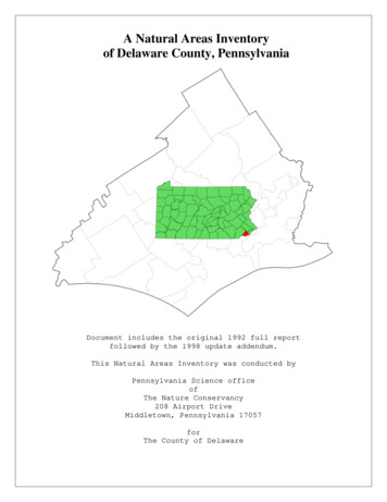
A Natural Areas Inventoryof Delaware County, PennsylvaniaDocument includes the original 1992 full reportfollowed by the 1998 update addendum.This Natural Areas Inventory was conducted byPennsylvania Science officeofThe Nature Conservancy208 Airport DriveMiddletown, Pennsylvania 17057forThe County of Delaware
A NATURAL AREAS INVENTORYOFDELAWARE COUNTY, PENNSYLVANIA1992
A NATURAL AREAS INVENTORYOFDELAWARE COUNTY, PENNSYLVANIA1992Anthony F. Davis, EcologistSarah B. Andersen, Assistant EcologistJulie A. Lundgren, Assistant EcologistAnthony M. Wilkinson, Coordinator/ZoologistJill R. Belfonti, Data ManagerJohn R. Kunsman, BotanistJoAnn C. Stanosz, Ecology InternPennsylvania Science OfficeofThe Nature Conservancy34 Airport DriveMiddletown, Pennsylvania 17057forThe County of DelawareThe preparation of this report was financed in part through funding from the U.S. Department ofHousing and Urban Development's Community Block Grant Program, and the PennsylvaniaDepartment of Community Affairs' Recreational Improvement and Rehabilitation Act GrantProgram (RIRA-TAG-6-12).
ACKNOWLEDGMENTS.1GLOSSARY .2INTRODUCTION.6DELAWARE COUNTY OVERVIEW .7PENNSYLVANIA NATURAL DIVERSITY INVENTORY DATA SYSTEM .11NATURAL AREAS INVENTORY METHODS .11SUMMARY AND RECOMMENDATIONS .14RESULTS.30USGS QUADRANGLE MAP: Bridgeport.32USGS QUADRANGLE MAP: Lansdowne.38USGS QUADRANGLE MAP: Marcus Hook.45USGS QUADRANGLE MAP: Media.51USGS QUADRANGLE MAP: Norristown.62USGS QUADRANGLE MAP: Philadelphia.65USGS QUADRANGLE MAP: Valley Forge.69USGS QUADRANGLE MAP: West Chester.71USGS QUADRANGLE MAP: Wilmington North.77USGS QUADRANGLE MAP: Woodbury.85LITERATURE CITED .89APPENDICES.90APPENDIX I.FEDERAL AND STATE STATUS, ANDNATURE CONSERVANCY RANKS .90APPENDIX IIPennsylvania Natural DiversityElement Occurrence Quality-Ranks .97APPENDIX III POTENTIAL NATURAL AREA SURVEY FORM.98APPENDIX IV RECOMMENDED NATURAL AREA FIELD SURVEYFORM.99APPENDIX V. CLASSIFICATION OF NATURAL COMMUNITIESIN PENNSYLVANIA .101APPENDIX VI. SPECIAL PLANTS AND ANIMALS OF DELAWARECOUNTY.105APPENDIX VII. MANAGEMENT AND STEWARDSHIP.111
ACKNOWLEDGMENTSWe would like to thank the Pennsylvania Department of Community Affairs for funding thisstudy under the Recreational Improvement and Rehabilitation Act Grant RIRA-TAG-6-12.We are especially grateful to the Natural Areas Inventory Study Committee and the manyindividuals who have contributed time and expertise to the study. The following individuals wereespecially helpful in the preparation of this report. Karen Holm of the Delaware County PlanningDepartment provided support and guidance throughout the study. Michael Ontko of the DelawareValley Regional Planning Commission provided aerial photographs of the county. John C. Miller,volunteer at the John Heinz National Wildlife Refuge at Tinicum, provided information on theoccurrence of birds of special concern in the Tinicum marsh. John Groves, curator of birds,amphibians, and reptiles at the Philadelphia Zoo, surveyed Delaware County for reptiles andamphibians of special concern. Dr. A.E. Schuyler of the Academy of Natural Sciences allowed us toutilize herbarium data and assisted in the survey and identification of plants on Little Tinicum Island.Julie Lundgren of PSO did much of the final editing of text and maps.Copies of this document may be obtained from:Delaware County Planning DepartmentToal Building2nd and Orange Sts.Media, PA 19063(215) 891-52001
GLOSSARYATV - all-terrain-vehicle.barrens - areas that are naturally infertile as a consequence of nutrient-poor soils; often form onresistant rock such as quartz, sandstone or highly weathered glacial material.effluent - waste water from septic systems or stormwater sewers.exotic - non-native; used to describe plant or animal species that were introduced by humans;examples include garlic mustard and Japanese honeysuckle; exotics may present a problem if theyare more competitive than native species.forb - non-grass herbaceous (non-woody) plant such as goldenrod.graminoid - grass-like plant such as a sedge or a rush.hydrology - water system of an area including both surface water and ground water.natural community - an example of a plant assemblage that is relatively undisturbed or has recoveredsufficiently to reflect the original plant community; only the best examples are considered forinclusion in the PNDI data base.non-point - refers to diffuse sources of pollution such as stormwater runoff contaminated with oil orpesticides.PNDI - Pennsylvania Natural Diversity InventoryPotential Natural Area - area that may have desirable environmental characteristics, but needs a fieldsurvey to confirm; a preliminary category given to sites prior to field survey.PSO - Pennsylvania Science Office of The Nature Conservancy (TNC)prescribed burning - burning under controlled conditions; needed to maintain communities such asserpentine barrens.seeps - unchannelized springs; water flows to the surface saturating the soil; often support lushherbaceous vegetation.succession - natural process of vegetation change through time; over time, the plant species of a sitewill change in composition and structure as light and soil conditions change.understory - layer of shrubs and small trees between the herbaceous layer and the canopy.2
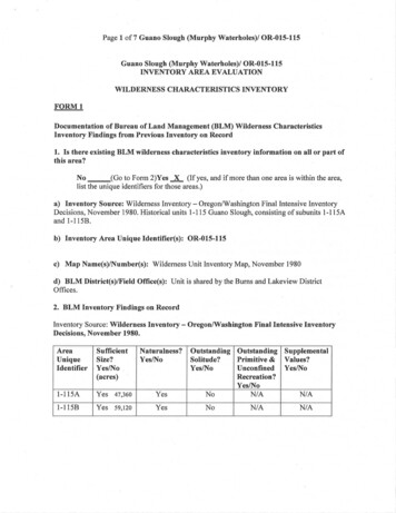
VALLEY FORGENORRISTOWNSite locationsrelative to USGSquadrangles1234MEDIAWEST CHESTER21121552 5116141348 46531852030312825 27 29244036333234545055474335373839MARCUS HOOKWILMINGTON NORTHPHILADELPHIA62223 2617 19454442 4149LANSDOWNE7891011BRIDGEPORTWOODBURY1Site locationsrelative to townships2RADNOR34NEWTOWN911 348Chadds Ford19CONCORD4954BE TH E L45444220 2440275031DARBYDARBYSP R IN G F IE RBETHEL38UPPER CHICHESTER55SPRINGFIELD2925174628MIDDLETOWN1452 51UPPER 373435
SiteNumber12345678910111213141516USGS QuadrangleValley ForgeValley iaMediaMediaMediaWest ChesterWest ChesterWest ChesterWest ChesterWest ChesterTownshipRadnorRadnor, town, e NameRadnor WoodsSkunk Hollow WoodsIthan Creek WetlandState Hospital WoodsDarby Creek Valley ParkFairmount ParkHunter Run SeepsCrum Creek WoodsCastle RockHunting Hill WoodsWillistown Serpentine BarrensCheyney WetlandBrinton Lake WetlandBethlehem Church WoodsGlen Mills School WoodsMarkham WoodsEdgewood Memorial ParkWoodsDarling WoodsWawa WoodsGlenwood School WoodsTyler Arboretum WoodlandsTyler ArboretumPink Hill BarrensWilliamson School BarrensMineral Hill WoodsMedia WetlandLong Point town, Upper Province282930313233Lower Crum ReservoirSwarthmore College WoodsSummit Road WoodsMt. Zion CemeteryJohn Heinz NwrLeedom Estates Park Site34353637383940414243Tinicum MacrositeHog IslandCar Wash Marsh At TinicumLittle Tinicum IslandEssington WetlandsChester Tidal FlatsCrozierville WoodsChester Creek West BranchSpring Run WoodsSun Oil WoodsMedia, owne, BridgeportLansdowne, Philadelphia,Bridgeport, rcus HookMediaMedia, Marcus HookMarcus HookMarcus Hook4Marple, Upper Province,Nether Province, SpringfieldNether cumTinicum, RidleyAstonAstonBethelBethel, Upper Chichester
4450495152Garnet Mine Road WoodsShavertown Woods / ClaytonParkElam WoodsJohnsons Corner/NaamanCreek Road SiteBrandywine Summit SEBeaver Valley Road PipelineSiteQuarry WoodsTodd WoodsBrinton Run Woods535455Chadds Ford SwampBrandywine Creek CorridorSmith Bridge Woods45464748Marcus HookMarcus Hook, WilmingtonNorthWilmington NorthBethelWilmington NorthWilmington NorthBethel, ConcordChadds FordWilmington NorthWilmington NorthWest ChesterWest ChesterWest Chester, WilmingtonNorthWilmington NorthWilmington NorthChadds FordConcord, Chadds FordChadds FordChadds Ford5Bethel, ConcordConcordChadds FordChadds FordChadds Ford
INTRODUCTIONDelaware County in southeastern Pennsylvania is a county of great variety. Intertidal marshcommunities dominated by cattails and leafy spatterdock, and home to many resident and migratorybirds, flourish along parts of the Delaware River. To the northwest, there are found picturesquefarmland, scattered mature wood lots of beech, oak, and tulip tree, and wet meadows. West ofMedia, patches of serpentine rock support globally imperiled plants among an assortment of morecommon grasses and wildflowers. Along the several stream corridors that cross the county, onefinds cool woodlands cloaking steep slopes and assorted floodplains and wetlands adjacent to thecreeks. Although the scenic beauty of the county is great, intense development, both historically andrecently, has diminished much of the original natural landscape. This report presents DelawareCounty's remaining outstanding natural heritage features - geologic, floral, and faunal - that deserveprotection for enjoyment by future generations.Delaware County's proximity to Philadelphia and Wilmington has made it a commuter'sparadise. Major traffic arteries including I-95, I-476 (Blue Route) and Route 1, and numeroussmaller highways criss-cross the county. Urban and suburban development has sprung up alongsidethese myriad roadways resulting in the loss of many scenic and natural environments. Wiseplanning is needed to maintain the remaining natural environments and associated plants andanimals while allowing for continued development. To achieve a balance between economic growthand preservation of biological diversity, development must be guided away from the mostenvironmentally sensitive areas. County and municipal government officials, the public, anddevelopers must know the location and importance of environmentally sensitive areas in order toprotect them. This knowledge of site location, quality, and significance can be used to avoid landuse conflicts and to allow for wise spending of limited conservation dollars.The Natural Areas Inventory of Delaware County provides maps of the best natural areas(natural communities) and the locations of all known animal and plant species of special concern(endangered, threatened, or rare)*. A written description and a summary table of the sites thatcontain these elements, including quality, degree of rarity, and last-observed date, accompany eachmap. In addition, the locations of some areas that cannot be deemed natural are also included.These sites are significantlocally because they are tracts of open land that provide wildlife habitat, offer a diversity of plantspecies and habitats, or are relatively mature woods. Some may also be areas that can help protector buffer water supply watersheds or are adjacent to already-existing parks or conservation lands.This report should be used in conjunction with other reports, such as open space plans prepared forMiddletown Township* Codes are used to identify these features on the maps. Rare plants and animals are subject tounauthorized collection and are not identified in the text in order to provide some measure ofprotection.6
(Natural Lands Trust 1988) and Radnor Township (Carter van Dyke Associates 1991), as well asother detailed creek valley or watershed studies, in an effort to conserve remaining open and naturallands in the county.An overall summary of the highest quality sites suggests protection and conservationoptions. The information and maps presented in this report provide a useful guide for planningdevelopment and as a supplement to municipal open space plans for parks and natural areas, andsetting protection priorities for preservation of the most vulnerable sensitive areas.DELAWARE COUNTY OVERVIEWClimate, geology, hydrology, topography, and soils have contributed to the growth anddevelopment of the forests, wetlands, and other natural communities located in Delaware County. Inaddition, human and natural disturbances have played an important role in the evolution of thesecommunities. A brief review of the geology, soils, vegetation types, and disturbance history ofDelaware County sets the stage for the remainder of the report.GeologyThe northwestern two-thirds of Delaware County is located in the Piedmont Uplands section ofthe Piedmont Physiographic Province. The southeastern third of the county, along the DelawareRiver, is in the Coastal Plain Physiographic Province. Each region bears a distinctive landscapereflecting the underlying geology.The Piedmont Uplands consists of complexly folded and faulted metamorphic and igneousrocks of Precambrian and Cambrian age (Geyer and Bolles 1979). Rock types include marble,schist, gneiss, quartzite, granite, and serpentinite. Weathering and erosion of these various rocktypes produces the rolling topography characteristic of much of the county. The major creekscutting down through these rocks on a southerly passage to the Delaware River include from east towest: Cobbs Creek, Darby Creek, Crum Creek, Ridley Creek, Chester Creek, Naamans Creek, andBrandywine Creek. The varied geology of the county is revealed in boulders and rock outcropsexposed along these creeks.The Coastal Plain has a gently undulating topography that is more subdued than that of thePiedmont Uplands. Unconsolidated to poorly consolidated layers of Quaternary-age sand, gravel,and clay underlie the Coastal Plain and dip gently to the east. Delaware County's thin sliver ofCoastal Plain along the Delaware River has been heavily developed for industrial and residentialuse. Tinicum marsh (within the John Heinz National Wildlife Refuge) is one of the few remainingCoastal Plain natural communities in Pennsylvania. Here, Darby Creek, freed from the confininghard rock valley of the Piedmont, meanders in a broad swath on its final approach to the DelawareRiver.7
SoilsSoils are important landscape components that reflect the underlying geology, provide themedium for plant growth, and determine land use to a large degree. Kunkle (1963) recognizes foursoil associations in Delaware County.The Glenelg-Manor-Chester association covers much of northern Delaware County andconsists of shallow to deep, silty and channery soils on grayish brown schist and gneiss.Traditionally, agriculture, dairy farming, and livestock production were primary land uses associatedwith these soils. More recently, much of this land has undergone conversion to suburbia.The Neshaminy-Glenelg association occurs in northern Delaware County and consists ofmoderately deep and deep, well drained, silty, channery, and gravelly soils on gabbro andgranodiorite. According to Kunkle (1963), soils of this association are best suited to hay productionand pasturage. As with the preceding association, much of the land occupied by these soils has beendeveloped for residential communities.The Neshaminy-Chrome-Conowingo association occurs as a broad belt west and north ofMedia and consists of moderately deep and deep, silty soils on serpentine. The soils of theassociation vary in drainage class with the Neshaminy being well drained and the Conowingo beingmoderately well drained to somewhat poorly drained. The unusual chemistry of the serpentine rockfrom which these soils derive - it is relatively rich in magnesium and poor in calcium and high incertain heavy metals - is reflected, to varying degrees, in the associated native vegetation and landuse. Coastal Plain species such as blackjack oak (Quercus marilandica) and western prairie grassessuch as prairie dropseed (Sporobolus heterolepis) thrive on the droughty serpentine soils. Where theserpentine effects are strongly expressed, agriculture has failed and has been abandoned for morefertile lands. Today, much of the area occupied by these unusual soils is in residential development.The Beltsville-Sassafras-Butlertown association develops on Coastal Plain sediments whichare found primarily along the Delaware River with a few, scattered patches occurring farther inland.The deep, silty or sandy soils of this association are not extensive in their occurrence in the county.While some of the lands occupied by these soils were farmed at one time, most of the land has beendeveloped for industrial use or residential communities.Vegetation TypesThe vegetation in Delaware County reflects the environmental conditions associated with thedifferent physiographic provinces and disturbance history.The woodlands of Delaware County are located in the Piedmont Section of the Oak-Chestnut8
Forest Region (Braun 1950). The Oak-Chestnut Region which extends from southern New Englandto northern Georgia was originally characterized by oaks and the American chestnut. Today, noneof the original primary vegetation of this forest-type remains because the chestnut blight, whichbegan in the early 1900's, eradicated a primary constituent of the forest community. At present, theforest of this region is classified as Mixed Oak Forest (Monk et al. 1990). Historical logging forlumber and fuel produced even-aged stands that range in age from 40 to 80 years (Keever 1972).Forested north-facing slopes are often dominated by beech while south-facing slopes areoften a mix of oaks and tulip poplar with beech a very minor component (Braun 1950). Commonassociates include red maple, white ash, hickory, black cherry, and sour-gum. Typical shrubsinclude spicebush, viburnums, and witch hazel. The herb layer is often lush with assorted ferns andwildflowers, many of which are spring ephemerals.Oaks dominate the crests of hills. Shallow, droughty, nutrient-poor soils support a shrublayer dominated by huckleberry, blueberry, and mountain laurel and a sparse herb layer containingplants such as partridgeberry.Serpentine-based communities represent anomalous vegetation types within the extensiveMixed Oak Forest. The structure and species composition of these communities range from veryexposed rocky or gravelly outcrops supporting a handful of drought-tolerant species such as roundleaved fame-flower (Talinum teretifolium) and serpentine aster (Aster depauperatus) to open prairiescontaining assorted western grass species to forests of post oak (Quercus stellata) and blackjack oakwith an understory of greenbrier. Disturbance such as fire affects the nature of the community andthe degree to which the serpentine effect is expressed. If periodic disturbance is suppressed, theunique serpentine communities may succeed to the ordinary background Mixed Oak Forestcommunity.Wet meadows, marshes and swamps have formed on the alluvial floodplain soils along somestreams and other water bodies. Water recedes from the wetlands as stream water levels drop andoften dry by late summer. These wetlands receive water that is relatively well aerated and high innutrients. Because of drying and aeration, fairly rapid decomposition processes preclude theaccumulation of much organic matter. Red and silver maple, white and green ash, box elder, andwillow are typical canopy species. Silky dogwood, arrowwood, and spicebush are common shrubspecies. A diversity of grasses, rushes, and sedges grow in open areas along with assorted herbs.Plant community and species zonation depends on flooding regimes and rates of soil drainage.Intertidal communities that are alternately bathed and exposed twice a day by the shiftingtide occur along the Delaware River and as far inland as the tidal influence extends. Mudflats occurin the lower part of the intertidal zone and are populated by scattered leafy emergents such asspatterdock and an assortment of arrowheads (Sagittaria spp.) with low, basal rosettes that areevident only at low tide. Marshes with robust grasses such as wild rice, bulrushes, and leafyemergents including pickerelweed, arrow arum, and common arrowhead occur in the upper part ofthe intertidal zone. Although these marshes are lush in mid-summer, they die back to bare mud each9
winter.DisturbanceThe nature, scale, and frequency of disturbance are influential factors in the evolution andappearance of natural communities. Disturbance can be beneficial or destructive to the developmentand persistence of natural communities.Fire, seen by most people as a destructive force, plays an important role in maintenance ofserpentine barren communities. In its absence, open areas where many of the rare serpentine speciesgrow, become overgrown with woody plants that shade out the light-loving species. Prescribedburning at Pink Hill in the Tyler Arboretum illustrates that controlled fires can be used to set backnatural succession processes and maintain the desired serpentine plants.In many cases, human disturbance has been clearly destructive. Large-scale disturbanceassociated with urbanization and suburbanization has completely eradicated existing naturalcommunities. Along the Delaware/Chester County border in Edgmont Township, recentdevelopment has obliterated a serpentine prairie community; illegal trash dumping (in evidence innearby Chester County) on unused serpentine land can be equally harmful in the long term.The Tinicum marsh provides a classic example of human mis-management. Over time, theonce-extensive marshland has shrunk in size as areas were filled for one reason or another. Formany years, the marsh was a landfill receiving unknown quantities and qualities of trash.Construction of the Philadelphia Airport and the extensive highway network and numerous supportfacilities surrounding the airport took away additional wetland. Disposal of dredge spoil, continuinginto the present, has further reduced the size and quality of marshland. A somewhat different impactto Tinicum marsh, was removal of gravels underlying the marsh near the I-95 Darby Creek bridgefor highway fill. The subsequent conversion of productive marshland to open water resulted in theloss of extensive wild rice stands and the displacement of migratory birds that fed on rice grains inlate summer and early fall. The U.S. Fish and Wildlife Service is attempting to maintain andimprove the condition of the remaining marsh at Tinicum.Some communities have recovered over a period of decades from activities such as loggingand farming to a composition and structure approaching the pre-settlement state. Scattered maturewood lots in Delaware County provide a sense of the stature of the original forest. It is important tomaintain a closed canopy in these mature forests to prevent the invasion of light-loving, exoticspecies.The introduction and spread of exotic species across the landscape is a monumental problemin the protection of biodiversity. Many of these non-native plants outcompete the desirable nativespecies. In woodlands throughout the county, garlic mustard (Alliaria petiolata), Japanesehoneysuckle (Lonicera japonica), and bittersweet (Celastrus orbiculata) are nuisance species.Japanese knotweed (Polygonum cuspidatum) and mile-a-minute plant (Polygonum perfoliatum)10
invade clearings and river shores. Common reed (Phragmites australis) and purple loosestrife(Lythrum salicaria) are aggressive, weedy species that creep into wetlands in the wake ofdisturbance and often overwhelm native species. Control of these weedy species is necessary for thelong-term maintenance of high quality natural systems.PENNSYLVANIA NATURAL DIVERSITY INVENTORY DATA SYSTEMIn order to plan the wise use of Delaware County's natural features, the PennsylvaniaScience Office (PSO) of The Nature Conservancy (TNC) entered into a contract with the DelawareCounty Planning Department to provide environmental data for use in site evaluations throughoutthe county. PSO/TNC was selected because of its reputation, as well as its link to the PennsylvaniaNatural Diversity Inventory (PNDI) database. PNDI was established in 1982 as a joint venture ofPSO/TNC, the Pennsylvania Department of Environmental Resources, and the WesternPennsylvania Conservancy. In its ten years of operation, the PNDI database has becomePennsylvania's chief storehouse of information on outstanding natural habitat types (called naturalcommunities in PNDI terminology), sensitive plant and animal species, heron rookeries, and severalother noteworthy natural features. Over 7,000 detailed occurrence records, largely the result of fieldsurveys, are stored in computer files and denoted on topographic maps. Additional data are stored inextensive manual files set up for over 150 natural community types, over 800 plant and animalspecies, about 650 managed areas, and for each of Pennsylvania's 881 7.5-minute USGS quadranglemaps.Beginning in 1982, PSO collected primarily existing data on occurrences of elements ofconcern, drawing from publications, herbarium and museum specimens, and the knowledge ofexpert botanists, zoologists, ecologists, and naturalists. From this foundation, PSO has focused itsefforts on, and begun systematic inventories of, the best occurrences of the priority elements.The PSO has used this systematic inventory approach to identify the areas of highest naturalintegrity in Delaware County. These areas, comprised of natural communities with theircharacteristic species, represent an estimated 85-90 percent of the biological diversity of an area(The Nature Conservancy 1988); the other 10-15 percent consists of sensitive plant and animalspecies which occur both within and outside these natural communities. The full range of biologicaldiversity within Delaware County can be conserved by protecting sites with the best occurrences ofthe county's natural communities and by protecting populations of the county's sensitive plant andanimal species. The natural community and sensitive species data are the basis for judging thebiological values of sites within the county.NATURAL AREAS INVENTORY METHODSMethods used in the Delaware County Natural Areas Inventory followed PNDI proceduresand those developed in Illinois (White 1978) and Indiana (Anonymous 1985). The inventory11
proceeds in three stages: 1) information is gathered from the PNDI database files, local experts, andmap and air photo interpretation; 2) a reconnaissance flight provides an overview of the county; and3) ground survey allows detailed documentation of site characteristics.Map and Air Photo InterpretationA list of natural features found in Delaware County was prepared from the PNDI databaseand from information volunteered by local individuals and organizations knowledgeable of thecounty. Photo interpreters familiarized themselves with the air photo characteristics of high qualitynatural communities already documented by PSO. Additional data such as vegetation maps, fieldsurveys, and soil maps were consulted to increase understanding of the county's environment.Because vegetation must often be classified at an ecosystem level, it was critical that an ecologist orperson with similar training interpret the maps and air photos.Work progressed systematically within the area encompassed by each USGS topographicmap. The natural area potential of all land parcels on a given USGS topographic map was assessedusing aerial photographs. Areas extending into adjacent counties were examined in their entirety.Topographic maps to be used during field surveys were marked to indicate locations and types ofpotential natural areas based on aerial photo characteristics. For example, wood lots having a"puffy" canopy texture, indicating large tree crowns, were marked as potential mature forests.Light-colored open areas were marked as potential serpentine barrens.Once some photo interpretation was completed, field surveys were conducted to determinewhat was actually on the ground to improve the accuracy and consistency of interpretation.Biologists finding minimally disturbed natural vegetation or species of special concern at a siteoutlined the site on a field map for future reference. In the lab, the photo signatures (characteristicpatterns, texture, tone of vegetation, and other features on the photos) of these sites were comparedwith other areas found on the photos to identify similar plant communities that could be checkedduring future surveys. Biologists consistently finding poor quality sites associated with particularphoto signatures could eliminate similar areas on the photos without field surveys.Field WorkExperienced PSO biologists conducted field surveys to evaluate the naturalness of habitatsand search for sensitive species.Workers categorized the vegetation by natural community type for each site visited. An evaluationof quality was made for each natural community, care being taken to give reasons for the qualityrank. Boundaries of the community types were redrawn, if needed, based on new field information.The Potential Natural Area (PNA) Inventory Form (Appendix III) was completed for eachcommunity with a quality-rank of "C" and above. Community information recorded included the12
dominant, common, and other species as well as disturbances to the community. The presence ofsensitive plants and
The County of Delaware The preparation of this report was financed in part through funding from the U.S. Department of Housing and Urban Development's Community Block Grant Program, and the Pennsylvania Department of Community Affairs' Recreational Improvement and Rehabilitation Act Grant Program (RIRA-TAG-6-12).