Transcription
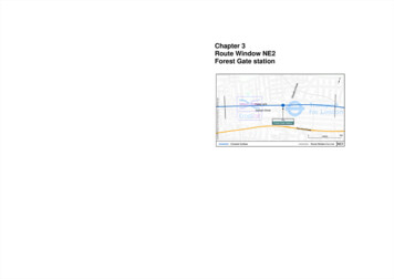
Chapter 3Route Window NE2Forest Gate stationTransportfor London
FOREST GATE STATION3Baseline conditionsRoute Window NE2Forest Gate station3.6This route window is in the London Borough of Newham and within Travelcard zone 3. Thestation is surrounded by a variety of commercial, residential and light industrial units. There arethree existing retail units directly south of the station and a local community school to the northof platform 4. There are a number of small businesses opposite the station on Woodgrange Road.The areas north and south of the station are predominately residential. Forest Gate station standson an overbridge on A114 Woodgrange Road. The station entrance is shown in fig. 3.1.Transportfor LondonIntroduction3.1All activities in this route window are associated with Forest Gate station, where it is intended toextend the Great Eastern Main Line platforms (island platform 2/3 and platform 1) toaccommodate 10-car Crossrail trains.3.2The Crossrail project will enhance public transport capacity between Forest Gate and Stratford,the City and West End. New and faster direct travel opportunities will be available from the City,West End, and points west to Maidenhead and Heathrow. Table 3.1 gives typical journey timeimprovements.3.3Figure 3.1 Station entrance, Woodgrange Road3.7Forest Lane, which runs along the north side of the railway line, is residential. It operates as atwo-way road, with a single lane in both directions.There are two worksites in this route window:xForest Gate Station Worksite West, which lies between Forest Lane and the railway,alongside the platform extensions;3.8Traffic volumes are generally high on Woodgrange Road in both directions at all times, and areparticularly high during the morning and evening peak hours.xForest Gate Station Worksite East, which lies alongside the railway on the other side, justwest of the overbridge that carries the station.3.9Forest Gate station is on the Liverpool Street to Shenfield Line (the Great Eastern Main Line).Travelling westbound, Forest Gate to Liverpool Street is ten minutes with four trains per hour inthe morning peak period. Eastbound the travel time to Shenfield is 31 minutes.The locations of the worksites are shown on Map NE2(iv).3.4The construction programme for the station works is expected to be about 10 months duringwhich time rail passengers using the station will be unaffected.3.10Wanstead Park station is 300 m further along Woodgrange Road. It will not be served byCrossrail.3.5The drawings provided at the end of this chapter present the main features of the route window,construction lorry routes assessed, existing facilities in the vicinity of Forest Gate station andtransport linkages.3.11Woodgrange Road forms part of several bus routes and has bus stops on both sides of the road.3.12The station does not have a taxi rank but there are several minicab offices close to the station.3.13There is no off-street car parking within the immediate vicinity of the station. The highwayoutside the station has parking restrictions in the form of single yellow lines. Short stay pay-anddisplay parking is available about 100 m south of the station on Woodgrange Road. A fewNE2 page 3
ROUTE WINDOW NE2residential roads do not have parking restrictions, but a recent survey suggested that the numberof available parking spaces is minimal.3.14There are several cycle routes leading to the station including LCN Route 12. Woodgrange Road,Earlham Grove, Osborne Road and Romford Road are all signposted cycle routes. EarlhamGrove has a short cycle contraflow system to allow cyclists two-way movement. There is cycleparking for approximately 24 cycles at the station.3.15There is a pelican crossing outside the station, which allows pedestrians easy access to thestation. The footway on Woodgrange Road outside the station is approximately five metres wide.As Woodgrange Road is also the local shopping centre, there is high pedestrian activity.3.16The station is close to a network of areas within Newham that are designated for their poor airquality, owing to their proximity to major roads.The permanent works3.17To accommodate 10-car Crossrail trains, island platforms 2 and 3 and platform 1 will beextended by 19 m. The tracks will be adjusted to accommodate the platform extensions, and thesignalling and overhead line equipment will be altered to suit.3.18Additional lighting will be provided, to extend over the whole length of the extended platforms.The platform furniture will be upgraded, with new seats and/or waiting shelters, as appropriate,and upgraded platform signs and CCTV coverage. No demolition will be necessary.Figure 3.2 Forest Gate Station Worksite West beyond the boundary wall, Forest Lane3.223.19The assessment has assumed that most of the materials and plant necessary to carry out the workswill be delivered by rail from a storage depot at the Manor Park station worksite (see RouteWindow NE3).Forest Gate Station Worksite East3.23This worksite occupies an area behind Durning Hall on Earlham Grove south of the railwayadjacent to platform 1 (see fig. 3.3 and Map NE2 (iv)). At present it is used as a loading andunloading area for the station kiosks. The only possible vehicular access to it is the narrowapproach off Earlham Grove leading to the Royal Mail sorting office, where there is a parkingcompound for Royal Mail vehicles (see fig. 3.4). A temporary right of way will be acquired forconstruction vehicles to access the worksite.3.24Earlham Grove is a residential street and operates as a one-way eastbound road with a contraflowcycle lane and ‘no-entry’ at the junction with Woodgrange Road. Vehicles are not permitted toenter Earlham Grove from Woodgrange Road.3.25This worksite will be used only as a storage area for the platform equipment and station furniture.It is therefore expected that only light goods vehicles (vans) will access the worksite. Theentrance to the worksite is narrow and is shared with Royal Mail. Working arrangements willhave to be discussed with Royal Mail.3.26The number of construction vehicles expected to be generated by this worksite will be low. Theconstruction plant and material will be transported by rail from the Manor Park Removal Loopworksite (see Route Window NE3).Worksite assessmentForest Gate Station Worksite West3.203.21This worksite is on railway land about 250 m west of the station building north of the GreatEastern Main Line (see Map NE2 (iv)). It is between the railway and Forest Lane, but there is novehicular access to it, since there is a high wall between the worksite and the road (see fig. 3.2).Ready-mixed concrete will be delivered by lorry and poured from the roadside in Forest Lanealongside the entrance to platform 4. It will be necessary to agree traffic managementarrangements with the London Borough of Newham to facilitate this work.Works will be carried out from within the existing fenced boundary of the railway and include asmall area to the south of the station (Forest Gate Station Worksite East) for storage. The workswill be serviced by a site on former railway land at the eastern end of Manor Park station (seeRoute Window NE3). A rail-mounted crane that will be used for lifting platform materials will belocated outside the construction site boundary in a siding adjacent to the construction works. Alllarge items of plant will be delivered and removed by rail. Other materials will be delivered bylorries to Forest Lane, which will be used a loading zone. Excavated materials will be removedby road.NE2 page 4No significant traffic or transportation impacts associated with this worksite have been identified.
FOREST GATE STATIONLorry routes assessment3.28There is no vehicular access to Forest Gate Station Worksite West.3.29Construction vehicles including vans will reach Forest Gate Station Worksite East from theTLRN at the Bow Interchange (from either A11 or A12) using the A118 High Street/RomfordRoad. Local access to the south will be from Sprowston Road then Earlham Grove. Vehicles willleave from the south on Earlham Grove via the A114 Woodgrange Road/Woodford Roadnorthwards, entering the TLRN (A12) at Wanstead.3.30An area of carriageway will be needed to allow ready-mixed concrete to be poured from theroadside on Forest Lane during platform construction. Lorries will reach it from High Street(A11), Great Eastern Road (A11), Romford Road, Woodgrange Road and Forest Lane. Vehiclesleaving the area will use Forest Lane as far as A11 or A12 via Stratford.3.31The area of highway needed will be on the westbound carriageway, but any disruption of trafficwill be mitigated by traffic management measures to be agreed with the London Borough ofNewham3.32No significant impacts on bus users or operators are expected, since the number of constructionvehicles travelling along the route is predicted to be only about 2 per cent of the present traffic.3.33The total number of lorry movements associated with works for Forest Gate station isapproximately 170. It is predicted that there will be around six lorry movements a day for theestimated six-week peak construction period. These lorry movements will not cause a significantimpact.Figure 3.3 Forest Gate Station Worksite East3.27No significant traffic or transportation impacts have been identified associated with this worksite.Mitigation and temporary impacts3.34There are no significant construction impacts to note in Route Window NE2, hence no mitigationis required.Mitigation and permanent impactsFigure 3.4 Access to Forest Gate Station Worksite East3.35The significant operational impacts and mitigation measures are indicated in Table 3.2.3.36There is one significant residual operational impact to note at Forest Gate Station relating topublic transport.3.37Passenger numbers with Crossrail are expected to increase by about 2,600 passengers enteringand 300 passengers leaving the station in the morning peak period (a 141 per cent increase twoway on the without Crossrail scenario). The 2016 with Crossrail flows predicted at the station areabout 4,950 two-way between 0700 and 1000 hours. The existing station facilities will besufficient for the forecast passengers. There are sufficient traffic and transport facilities in thevicinity of this station to cater for the forecast passengers.3.38Traffic levels are forecast to increase significantly along three links. Firstly, Woodgrange Roadbetween Forest Lane and Dames Road will experience a significant increase during the morningpeak hour. This would result in a flow of about 1150 vehicles two-way, an extra 12 per cent oftraffic. Secondly, Woodgrange Road between Forest Lane and Romford Road will experience aNE2 page 5
ROUTE WINDOW NE2significant increase during the morning peak hour. This would result in a flow of about 1400vehicles two-way, an extra 12 per cent of traffic. Both of these links experience congestion.3.393.40traffic. It is considered that this would be within current highway capacity and will not have anyadverse impact on traffic operation.There are measures that can be carried out for the benefit of road users and pedestrians that willmitigate these impacts; however, these will require further consents to be obtained before theycan be implemented. In line with the approach set out in Volume 8a, an assessment of the impactof Crossrail has been carried out that assumes that such measures are in place.3.41Forest Lane is the third link that Road will experience a significant increase during the morningpeak hour. This would result in a flow of about 590 vehicles two-way, an extra 30 per cent of3.42Table 3.1 Journey time savings (platform-to-platform) to and from Forest Gate stationToForest GateFromForest GateFrom/toHeathrowTottenhamCourt RoadFarringdonCanaryWharfWithout Crossrail55242119With Crossrail491613156884Saving (%)11%33%38%19%Without Crossrail48292423With Crossrail45161315Saving (minutes)313118Saving (%)6%43%47%Saving (minutes)Significant impacts on rail users at Forest Gate are forecast. Rail passengers are forecast toexperience significant journey time benefits. These are discussed below.Impact on rail journey timesTable 3.1 sets out representative journey time savings between Forest Gate and selected stationsduring the morning peak period. They are typical of the journey time benefits to many of thestations on Crossrail.Table 3.2 Route Window NE2 – Permanent impactsPotential impactSignificanceCommitted mitigationResidual ImpactDescriptionSignificanceTraffic levelsOT1aForest Lane, 30 percent increase in trafficto about 590 vehiclestwo-way in the morningpeak hourSignificantTraffic can beaccommodatedwithin the currenthighway capacityN/aNonsignificantOT1bWoodgrange Road,north of Forest Lane,12 per cent increase intraffic to about 1150vehicles two-way in themorning peak hourSignificantAn appropriatepackage of mitigationmeasures will bedeveloped in duecourse to addresspedestrian andhighway impacts.This package willrequire furtherconsents to beobtained. Pleaserefer to 3.39.N/aNonsignificantOT1bWoodgrange Road,south of Forest Lane,12 per cent increase intraffic to about 1400vehicles two-way in themorning peak hourSignificantAn appropriatepackage of mitigationmeasures will bedeveloped in duecourse to addresspedestrian andhighway impacts.This package willrequire furtherconsents to beobtained. Pleaserefer to 34%Public transportOT2cNE2 page 6Improved journey time–see journey timestable.
Transportfor LondonTransportfor LondonTransportfor London
Transportfor LondonTransportfor LondonTransportfor London
Worksite assessment Forest Gate Station Worksite West 3.20 This worksite is on railway land about 250 m west of the station building north of the Great Eastern Main Line (see Map NE2 (iv)). It is between the railway and Forest Lane, but there is no vehicular access to it, since there is a high wall between the worksite and the road (see fig. 3.2).