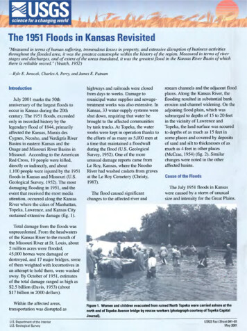
Transcription
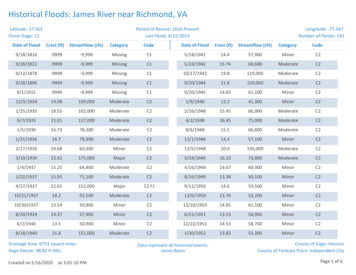
Historical Floods: James River near Richmond, VALatitude: 37.563Flood Stage: 12Date of FloodPeriod of Record: 1816-PresentLast Flood: 4/22/2019Crest (ft)Streamflow (cfs)CategoryCodeDate of FloodLongitude: -77.547Number of Floods: 193Crest (ft)Streamflow 94913.3850,100MinorC24/27/193722.65152,000MajorC2 norC2Drainage Area: 6753 square milesGage Datum: 98.82 ft MSLCreated on 1/16/2020at 3:01:10 PMData represent all historical events.James BasinCounty of Gage: HenricoCounty of Forecast Point: Independent CityPage 1 of 6
Date of FloodCrest (ft)Streamflow (cfs)CategoryCodeDate of FloodCrest (ft)Streamflow norC2Drainage Area: 6753 square milesGage Datum: 98.82 ft MSLCreated on 1/16/2020at 3:01:10 PMData represent all historical events.James BasinCounty of Gage: HenricoCounty of Forecast Point: Independent CityPage 2 of 6
Date of FloodCrest (ft)Streamflow (cfs)CategoryCodeDate of FloodCrest (ft)Streamflow 9816.7787,000ModerateC2Drainage Area: 6753 square milesGage Datum: 98.82 ft MSLCreated on 1/16/2020at 3:01:10 PMData represent all historical events.James BasinCounty of Gage: HenricoCounty of Forecast Point: Independent CityPage 3 of 6
Date of FloodCrest (ft)Streamflow (cfs)CategoryCodeDate of FloodCrest (ft)Streamflow /201612.1743,200MinornoneDrainage Area: 6753 square milesGage Datum: 98.82 ft MSLCreated on 1/16/2020at 3:01:10 PMData represent all historical events.James BasinCounty of Gage: HenricoCounty of Forecast Point: Independent CityPage 4 of 6
Date of FloodCrest (ft)Streamflow 2.3544,600MinornoneDrainage Area: 6753 square milesGage Datum: 98.82 ft MSLCreated on 1/16/2020at 3:01:10 PMDate of FloodData represent all historical events.James BasinCrest (ft)Streamflow (cfs)CategoryCodeCounty of Gage: HenricoCounty of Forecast Point: Independent CityPage 5 of 6
Date of FloodCrest (ft)Streamflow (cfs)CategoryCodeDate of FloodCrest (ft)Streamflow (cfs)CategoryCodeCode DescriptionC1Crest information looks unreliable and incomplete and not used in frequency calculations. Some of the floods are based on current flood stage and nearbygage information.C2Crest information looks reliable despite potential problems. This data was used in frequency calculations.C3Crest height estimated by the USGS.C4Crest height is from the National Weather Service.C5Crest height affected by backwater.C6Crest occurred at a previous flood stage that is lower than the current flood stage. The crests below the new flood stage are not used in flood frequencycalculations.C7Crest from USGS yearly peak and/or date is different than the crest we provide. In many cases MARFC uses crest based on backwater or ice effects.C8Crest month or day of occurrence has been estimated by The Middle Atlantic River Forecast Center usually based on nearby gage information.C9Crest date (day) in the month is unknown.F1F2F3F4F5Flow is an estimate.Flow affected by regulation or diversion and in some cases to an unknown degree.Flow effected by snow-melt, ice jam or debris jam break up.Flow affected by dam failure.Flow - All or part of the record affected by urbanization, mining, agricultural changes, channelization or other factors.G1G2Gage height at a different site and/or datum.Gage is not an official USGS gage with crests provided by the NWS. Crest information looks unreliable and incomplete and not used in flood frequencycalculations.Gage datum changed during this year.G3none No code; Good DataDrainage Area: 6753 square milesGage Datum: 98.82 ft MSLCreated on 1/16/2020at 3:01:10 PMData represent all historical events.James BasinCounty of Gage: HenricoCounty of Forecast Point: Independent CityPage 6 of 6
Historical Floods: James River near Richmond, VA Latitude: 37.563 Longitude: -77.547 Last Flood: 4/22/2019 Period of Record: 1816-Present Flood Stage: 12 Number of Floods: 193 Date of Flood Crest (ft) Streamflow (cfs) Category Code Date of Flood Crest (ft) Streamflow (cfs) Category Code 9/18/1816 -9999 -9,999 Missing C1 9/28/1822 -9999 -9,999 .