Transcription
Date of Submission22 March 2021IPL Project (IPL - 248) Annual Report Form 20201 January 2020 to 31 December 20201. PROJECT NUMBER (approved year) AND TITLE:IPL – 248 (2019): Innovation in slow-moving landslide risk assessment of roads and urban sitesby combining multi-sensor multi-source monitoring data2. MAIN PROJECT FIELDS(1) Technology DevelopmentA. Monitoring and Early Warning,B. Hazard Mapping, Vulnerability and Risk Assessment3. NAME OF PROJECT LEADER: Dario Peduto, PhDAffiliation: Associate Professor, Geotechnical Engineering Group (GEG), Dept. of Civil Engineering, Universityof Salerno (Italy), ICL Associate MemberContact: Via Giovanni Paolo II, 132 - 84084 - Fisciano (SA), Office: 39089964120; email: dpeduto@unisa.itCore members of the Project Biljana Abolmasov, Full Professor, Department of Geotechnics, Faculty of Mining and Geology (FMG),University of Belgrade (UNIBG), Serbia. Uroš Đurić, Teaching Assistant, Department of Geotechnical Engineering, Faculty of Civil Engineering(FCE), University of Belgrade (UNIBG), Serbia Settimio Ferlisi, Associate Professor, Geotechnical Engineering Group (GEG), University of Salerno Diego Reale, Researcher, National Research Council, Institute for Electromagnetic Sensing of theEnvironment (CNR-IREA), Naples (Italy)Contributors Gianfranco Nicodemo, Associate Researcher, Geotechnical Engineering Group (GEG), University of Salerno Fornaro Gianfranco, Research Leader, National Research Council, Institute for Electromagnetic Sensing ofthe Environment (CNR-IREA), Naples (Italy) Miloš Marjanović, Assistant Professor, Faculty of Mining and Geology, University of Belgrade.
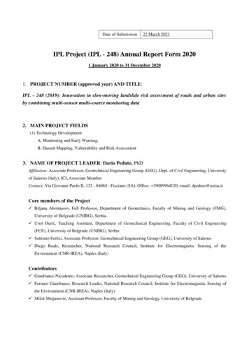
4. OBJECTIVES: (5 lines maximum)The project is aimed at developing and testing appropriate procedures for the use of innovative multi-temporalmulti-sensor monitoring techniques jointly with multi-source field data for the landslide hazard, vulnerabilityand risk assessment in (slow-moving) landslide-affected areas. The proposed procedures will be double-testedin different geo-environmental contexts taking advantage of previous/ongoing studies carried out by the Projectmembers in selected areas in both Italy and Serbia.5. STUDY AREA: (2 lines maximum)Some study areas severely affected by slow-moving landslides were selected in both countries: Calabria regionand Cilento area, southern Italy; and SW Belgrade suburb (Umka landslide) in Serbia.6. PROJECT DURATION (1 line maximum)3 years7. REPORT7.1 Progress in the project: (30 lines maximum)According to the approved proposal, the Project is arranged in six phases. The first two phases were expectedto be carried out during the first year.As for Phase I, collection, review, harmonization of information on landslides in the study areas of Calabriaregion in Italy and in Belgrado area (Serbia) were collected and harmonized. These data deal with types, stateof activity, involved soils, available monitoring data of the analyzed landslides.Furthermore, damage fact-sheets were filled in and collected for the exposed buildings/roads in both studyareas.As for Phase II, a dataset of 100 satellite Synthetic Aperture Radar (SAR images acquired by the ItalianCOSMO-SkyMed constellation on descending orbit over the period spanning from 2012/01/26 to 2016/01/05were processed just for the purpose of this IPL project. The dataset has been processed at the full availableresolution through the Multipass Differential Interferometric technique. Specifically the SAR Tomographyapproach has been implemented to estimate the component of the surface deformation along the satellite radarLine-of-Sight.An overview of the deformation mean velocity estimated by the DInSAR SAR Tomography processing on thearea imaged by the radar, including Belgrade city center and its surroundings, and a close-up view on the Umkalandslide are shown in Figures 1a and 1b.
Fig.1 a) An overview of the deformation mean velocity estimated by the DInSAR SAR Tomography processingon the area imaged by the radar, including Belgrade city center and its surroundings; b) a close-up view on theUmka landslide.7.2 Planned future activities or Statement of completion of the Project (15 lines maximum)In agreement with the project proposal, in the second year of the project the three institutions involved will
work on the assessment of landslide hazard (Phase III) based on (remote sensing and conventional) monitoringdata. These latter will be jointly used with the outcomes of in-situ damage surveys to derive empiricalfragility/vulnerability functions relating displacements and damage on both roads and buildings at large scale(Phase IV).Up to now, the full exchange of best practice and expertise among the different partners has been slowed downbecause of Covid pandemic that did not allow the scheduled joint technical visits to the study areas due totravelling problems among European countries.7.3 Beneficiaries of Project for Science, Education and/or Society (15 lines maximum)Direct beneficiaries of the project are community/municipalities affected by landslides. Localand regional authorities in both Italy and Serbia – housing sector, infrastructure authorities, Civilprotection departments – were contacted and will be informed about the results of the projectduring the second and third years of the project development.The preliminary results were disseminated to PhD students and Young Doctors attending the lastedition of LARAM2020 “LAndslide Risk Assessment and Mitigation" International School –which is yearly organized by GEG-UNISA with the contribution of several ICL members – byProf. Dario Peduto during his two lessons on “DInSAR-based landslide characterization” (on 15September 2020) and “Landslide vulnerability assessment” (on 16 September).7.4 Results: (15 line maximum, e.g. publications)Peduto D., Santoro M., Aceto L., Borrelli L., Gullà G. (2021). Full integration of geomorphological, geotechnical,A-DInSAR and damage data for detailed geometric-kinematic features of a slow-moving landslide in urban area.Landslides, 18(3):807–825, DOI: 10.1007/s10346-020-01541-0.Peduto D., Nicodemo G., Nappo N., Gullà G. (2021) Innovation in Analysis and Forecasting of Vulnerability toSlow-Moving Landslides. In: Guzzetti F., Mihalić Arbanas S., Reichenbach P., Sassa K., Bobrowsky P.T., TakaraK. (eds) Understanding and Reducing Landslide Disaster Risk. WLF 2020. ICL Contribution to LandslideDisaster Risk Reduction. Volume 2 “From Mapping to Hazard and Risk Zonation”, pp.441-446. Springer, Cham.https://doi.org/10.1007/978-3-030-60227-7 51, Print ISBN978-3-030-60226-0, Online ISBN978-3-030-60227-7, Springer Nature Switzerland AG 2021Abolmasov B., Đurić U., Popović J., Pejić M., Samardžić Petrović M., Brodić N. (2021) Results of RecentMonitoring Activities on Landslide Umka, Belgrade, Serbia—IPL 181. In: Sassa K., Mikoš M., Sassa S.,Bobrowsky P.T., Takara K., Dang K. (eds) Understanding and Reducing Landslide Disaster Risk. WLF 2020. ICLContribution to Landslide Disaster Risk Reduction. Vol 1”Sendai Landslide Partnerships and Kyoto LandslideCommitment”, pp.225-234., Print ISBN 978-3-030-60195-9, On-line ISBN 978-3-030-60196-6, SpringerNature Switzerland AG 2021. https://doi.org/10.1007/978-3-030-60196-6 14
Samardžić Petrović M., Popović J., Đurić U., Abolmasov B., Marjanović M. (2020). Pemanent GNSS monitoring oflandslide Umka. Borković A., Malinović M., (eds.): Proceedings of the XIVth International Conference ofContemporary Theory and Practice in Construction, 11-12 June 2020, Banja Luka, Bosnia and Herzegovina.University of Banja Luka, Faculty of Architecture Civil Engineering and Geodesy, 2020, pp 91 - 98. ISSN2566-4484
IPL Project (IPL - 248) Annual Report Form 2020 1 January 2020 to 31 December 2020 1. PROJECT NUMBER (approved year) AND TITLE: IPL - 248 (2019): Innovation in slow-moving landslide risk assessment of roads and urban sites by combining multi-sensor multi-source monitoring data 2. MAIN PROJECT FIELDS (1) Technology Development