Transcription
Marine Safety Information LeafletJune 2018
MARITIME SAFETY INFORMATION LEAFLETRECORD OF CHANGESThe table below documents the version history of the Maritime Safety Information (MSI) leaflet.VersionDateStatus101/01/2010First pprovedHead of Navigation Safety Branch, MCAAndré Cocuccio, Assistant DirectorNavigation Safety, MCAPUBLISHED BY THEMARITIME & COASTGUARD AGENCYSPRING PLACE105 COMMERCIAL ROADSOUTHAMPTONHAMPSHIRESO15 1EGUKMCA Switchboard Tel: 023 8032 9100E–mail: infoline@mcga.gov.ukWeb: www.gov.uk/mcaThis publication will be revised and updated periodically as changes dictate.For the most current up-to-date version, please afety-information-leafletMARITIME & COASTGUARD AGENCY CROWN COPYRIGHT
MARITIME SAFETY INFORMATION LEAFLETWEATHER BROADCASTS AND MARITIME SAFETY INFORMATIONHer Majesty’s Coastguard is responsible in the UK for the broadcast of marine weather forecasts andMaritime Safety Information (MSI) on NAVTEX, VHF and MF and for providing the Radio Medical AdviceLink Call (MEDILINK) Service.COVERAGEThe primary method of disseminating MSI is by NAVTEX which provides coverage out to 270 miles. Thisservice is complemented by radio telephony broadcasts. HM Coastguard provides VHF coverage out to30 miles and MF coverage out to 150 miles using its network of remote aerial sites around the UK coast.Information about weather and MSI broadcasts from other European and worldwide national authoritiescan be obtained from: http://weather.gmdss.org/NAVTEXMSI and additional weather information is transmitted by NAVTEX on 518 kHz in English at the followingtimes (UTC):CULLERCOATS – 518 kHz (G)Gale Warnings - when received and at:24-hour Forecast and OutlookExtended Outlook (3-5 days)WZ Navigation WarningsTidal Surge WarningsNavarea 1 Warnings01:00; 05:00; 09:00; 13:00; 17:00; 21:0009:00; 21:0001:0001:00; 05:00; 09:00; 13:00; 17:00; 21:00When received05:00; 17:00NITON – 518 kHz (E)Gale Warnings - when received and at:24-hour Forecast and OutlookExtended Outlook (3-5 days)WZ Navigation WarningsTidal Surge WarningsSUBFACTS & GUNFACTSNavarea 1 Warnings00:40; 04:40; 08:40; 12:40; 16:40; 20:4008:40; 20:4000:4000:40; 04:40; 08:40; 12:40; 16:40; 20:40When received04:40; 16:4004:40; 16:40PORTPATRICK - 518 kHz (O)Gale Warnings - when received and at:24-hour Forecast and OutlookExtended Outlook (3-5 days)WZ Navigation WarningsSUBFACTS & GUNFACTSNavarea 1 Warnings02:20; 06:20; 10:20; 14:20; 18:20; 22:2006:20; 18:2002:2002:20; 06:20; 10:20; 14:20; 18:20; 22:2006:20; 18:2002:20; 14:20OOSTENDE - 518 kHz (T)Gale Warnings (Dover & Thames)Weather Forecast03:10; 07:10; 11:10; 15:10; 19:10; 63:1007:10; 19:10OOSTENDE - 518 kHz (V)Navigation Warnings03:30; 07:30; 11:30; 15:30; 19:30; 23:30Note: Weather information broadcast from this site is from Belgian sources not the Met Office.1MARITIME & COASTGUARD AGENCY CROWN COPYRIGHT
MARITIME SAFETY INFORMATION LEAFLETMALIN HEAD - 518 kHz (Q)Gale Warnings (Irish Sea, Shannon,Rockall, Malin and Bailey)Gale Warnings and 24-hour Forecast Shannon, Rockall, Malin and BaileyIrish Navigation Warnings for North, NWand W coasts of Ireland and approaches02:40; 06:40; 10:40; 14:40; 18:40; 22:4006:40; 18:4002:40; 10:40; 14:40; 22:40If you have broadcast issues relating to NAVTEX, contact your nearest Coastguard Operations Centre.INSHORE WATERS FORECASTS AND STRONG WIND WARNINGSThe 490 kHz NAVTEX service provides the Inshore Waters Forecast (IWF) and also Strong Wind Warning(SWW) on receipt. Current weather observations are broadcast once only at the next available broadcastschedule as shown below:CULLERCOATS – 490 kHz (U)Inshore Waters Forecast - Areas 1 to 5 and 18Current weather observations – Eastern coastal areas07:20; 11:20; 19:20; 63:2003:20; 11:20; 15:20; 23:20NITON - 490 kHz (I)Inshore Water Forecast - Areas 5 to 9 and 1901:20; 05:20; 13:20; 17:20Current weather observations – South coastal areas and 01:20; 09:20; 13:20; 21:20English ChannelPORTPATRICK - 490 kHz (C)Inshore Waters Forecast - Areas 9 - 17Current weather observations – Western coastal areas00:20; 08:20; 12:20; 20:2000:20; 04:20; 12:20; 16:20Malin Head – 490 kHz (A)Inshore Water Forecast - Areas 13 to 1700:00; 04:00; 08:00; 12:00; 16:00; 20:00Note: NAVTEX provides information for its own area of coverage only. Make sure that you select theappropriate B1 transmitter identity for the area you are travelling towards as well as the area that you arecurrently operating in. You must also make sure that the B2 subject indicator is set to 'V' in order to receive490 data from UK sites. As well as the UK NAVTEX transmitters, in some locations, the service is wellserved by foreign NAVTEX transmitters broadcasting the 518 service in English.RADIO TELEPHONY BROADCASTSFull MSI broadcasts will be made by radio telephony (R/T) twice a day. A new Inshore Waters Forecast,and any Gale or Strong Wind Warnings, will be broadcast every three hours. All broadcast times shownare in local time.FREQUENCIESFrom 10:00 hours on 6 September 2017 MSI is permanently broadcast on VHF channels 62, 63 or 64.The use of VHF Channel 10 for MSI backup and pollution control remains unchanged. This preventsinterference and allows broadcasts to be made simultaneously on two or more aerials. Because of thelength of some broadcasts this system minimises the delay in transmitting the information to all mariners.2MARITIME & COASTGUARD AGENCY CROWN COPYRIGHT
MARITIME SAFETY INFORMATION LEAFLETNAVIGATIONAL WARNINGSUK Coastal Navigational Warnings (WZ) and NAVAREA I warnings are provided by the UK HydrographicOffice. The primary means of disseminating this information is by NAVTEX and INMARSAT SAFETYNET.Coastal WZ are also broadcast on VHF and MF on selected aerials, when we receive them and at twelvehourly intervals (see broadcast schedules). Rig movements (RIGMOVES) and pipe-laying operations arenot included within these broadcasts.METEOROLOGICAL INFORMATIONA new Inshore Waters Forecast, and any Gale or Strong Wind Warnings, will be broadcast every threehours (local time). Shipping Forecasts for UK sea areas are broadcast twice daily. Gale Warnings for UKsea areas are broadcast as soon as possible after they are received and are valid for 24-hours unlesscancelled. Any Gale Warning still in force after the 24-hour period will be renewed.A Strong Wind Warning (SWW) will be issued if the wind speed in an Inshore Waters Forecast area ispredicted to be Force 6 or more and was not identified in the previous Inshore Waters Forecast. SWW arevalid only until the next new Inshore Waters Forecast. These warnings will be broadcast on receipt andmay be included in the repetition broadcast. The legend 'SWW' will be included in the Inshore WatersForecast to indicate that a Strong Wind Warning is in operation for the time covered by the forecast.VHFMSI will be broadcast by HM Coastguard on either VHF channels 62, 63 or 64, in the routines describedbelow, at the times shown in the following table.Routine A (VHF & MF)Full MSI broadcast – new Gale Warnings, Storm Warnings and Navigation Warnings will be broadcastwhen received. Such warnings may be announced on Digital Selective Calling (DSC). The local InshoreWaters Forecast and Outlook, Shipping Forecast, WZ Navigation Warnings, SUBFACTS & GUNFACTSand the Three-Day Fisherman’s Forecast, will be broadcast when and where appropriate. (Three-dayFisherman’s Forecasts, primarily for the benefit of fishing fleets in the North Sea, Northern and WesternIsles and the South Western Approaches, are broadcast from 1st October until 31st March).Routine B (VHF Only)New Gale Warnings, Storm Warnings and Navigation Warnings, local Inshore Waters Forecast andOutlook will be broadcast on VHF & MF when received. Such warnings may be announced on DigitalSelective Calling (DSC).3MARITIME & COASTGUARD AGENCY CROWN COPYRIGHT
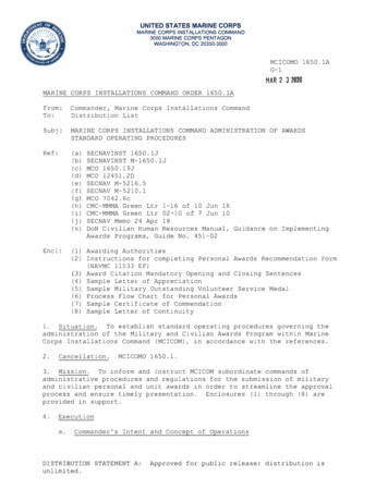
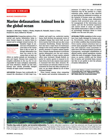
MARITIME SAFETY INFORMATION ngForecast areasVikingCromartyFair isleFaroesInshoreWatersForecast areas1 - Cape Wrath toRattray Head, includingOrkney18 - Shetland Isles and60 nautical mile radiusBroadcast times Abroadcast (local time)0710 & 1910Broadcast times Bbroadcast (local time)0110, 0410, 1010,1310, 1610, ulWidefordCollafirth MFVHF channel /MF frequency63646263641770 KHzAberdeenCoastguardFortiesCromartyForthTyneFair Isle1 - Cape Wrath toRattray Head, includingOrkney,2 - Rattray Head toBerwick-upon-Tweed0730 & 19300130, 0430, 1030,1330, 1630, 2230DurnessNoss HeadRosemarkieWindy HeadGregnessInverbervieFifenessCraigkellySt Abbs headGregness MF6362646364636263642226 KHzHumberCoastguardTyneDoggerFisherGerman BightHumberThames3 - Berwick-upon-Tweedto Whitby4 - Whitby to GibraltarPoint5 - Gibraltar Point toNorth Foreland0750 & 19500150, 0450, 1050,1350, 1650, 2250DoverCoastguardHumberThamesDoverWight5 - Gibraltar Point toNorth Foreland 6 - NorthForeland to Selsey Bill0710 & 19100110, 0410, 1010,1310, 1610, ingtonMablethorpeGuys headLanghamTriminghamCaisterLowestoftCullercoats t6364636463646263646364631925 KHz6263646364624MARITIME & COASTGUARD AGENCY CROWN COPYRIGHT
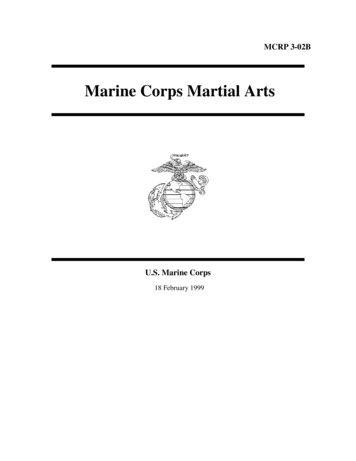
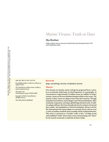
MARITIME SAFETY INFORMATION Forecast ortlandPlymouthSoleLundyFastnetMilford HavenCoastguardLundyFastnetIrish seaInshoreWatersForecast areas6 - North Foreland toSelsey Bill7 – Selsey Bill to LymeRegis8 - Lyme Regis toLand’s End, includingthe Isles of Scilly8 - Lyme Regis toLand’s End, includingthe Isles of Scilly9 - Land’s End to StDavid’s Head, includingthe Bristol ChannelBroadcast times Abroadcast (local time)0730 & 1930Broadcast times Bbroadcast (local time)0130, 0430, 1030,1330, 1630, dBeer HeadVHF channel /MF frequency62636263620710 & 19100110, 0410, 1010,1310, 1610, 2210Berry HeadDartmouthPrawleRame HeadFoweyFalmouthLizardScilliesTrevoseScillies MF6310626410626364621880 KHz9 - Land’s End to StDavid’s Head, includingthe Bristol Channel10 - St David’s Head toGreat Orme’s Head,Including St George’sChannel0750 & 19500150, 0450, 1050,1350, 1650, 2250HartlandCombe MartinSevernSt HilaryMumblesTenbySt AnnsDinasBlaenplwyf6463646364626264625MARITIME & COASTGUARD AGENCY CROWN COPYRIGHT
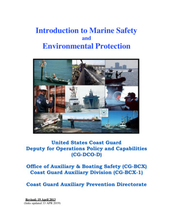
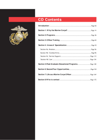
MARITIME SAFETY INFORMATION ppingForecast areasIrish SeaInshoreWatersForecast areas10 - St David’s Head toGreat Orme’s Head,Including St George’sChannel11 - Great Orme’s Headto the Mull of Galloway11 - Great Orme’s Headto the Mull of Galloway12 - Isle of ManBroadcast times Abroadcast (local time)0750 & 1950Broadcast times Bbroadcast (local time)0150, 0450, 1050,1350, 1650, 2250BroadcastaerialsGreat OrmeSouth StackVHF channel /MF frequency6463HolyheadCoastguard(B) h Sea0730 & 19300130, 0430, 1030,1330, 1630, rish SeaMalinHebridesRockall12 - Isle of Man13 – Lough Foyle toCarlingford Lough14 – Mull of Galloway toMull of Kintyre includingthe Firth of Clyde andNorth Channel15 - Mull of Kintyre toArdnamurchan Point2010 & 08100210, 0510, 1110,1410, 1710, air IsleFaeroesSoutheastIceland15 - Mull of Kintyre toArdnamurchan Point16 – The Minch17 - ArdnamurchanPoint to Cape Wrath0710 & 191019 – Channel IslandsLimivadyWest TorrBlack-MountainOrlockLoughnavarSlieve MartinGreenockLaw hillRhu StaffnishKilchiaranSouth-KnapdaleTiree MF0110, 0410,Torasay1010, 1310, lettravalRodelMelvaigForsnavalPortnaguranButt of LewisButt of Lewis MFAvailable on request via telephone10646362646462641062631883 KHz106362641063106362646263101743 KHz6MARITIME & COASTGUARD AGENCY CROWN COPYRIGHT
MARITIME SAFETY INFORMATION LEAFLETMFMSI Broadcasts will continue to be broadcast from the following MF Radio Sites on the designatedfrequencies shown below, with an initial announcement on 2182 kHz MF.Tiree and Butt of Lewis may also include GUNFACTS and SUBFACTS information on MF relevant to NorthAtlantic NATO exercises, but only when advised by the Ministry of Defence.MF Radio SiteTireeShetlandButt of LewisScilliesGregnessCullercoatsFrequency1883 kHz1770 kHz1743 kHz1880 kHz2226 kHz1925 kHzRoutine A08:10, 20:1007:10, 19:1007:10, 19:1007:10, 19:1007:30, 19:3007:50, 19:50BBC RADIO 4 WEATHER BULLETINSRadio 4 broadcasts weather bulletins as follows:00:48LW, MW, FM05:20LW, MW, FM12:00LWGale Warnings, Shipping Forecast, weather reports from coastalstations and the Inshore Waters ForecastGale Warnings, Shipping Forecast, weather reports from coastalstations and the Inshore Waters ForecastGale Warnings, Shipping Forecast17:54LW (FM weekends only)Gale Warnings, Shipping ForecastRADIO MEDICAL ADVICE LINK CALLS (MEDILINK)If the Master or Skipper of any vessel requires medical advice, they should contact the Coastguard onVHF channel 16 (156.8 MHz), VHF or MF DSC, requesting “Radio Medical Advice”. In an urgent situation,you should broadcast an Individual Urgency alert using VHF or MF DSC followed by a call VHF channel16 or MF 2182 kHz, and Using the Standard Marine Communication Phrase "PAN PAN".The Coastguard will give priority to requests for Radio Medical Advice. A doctor from a hospitalparticipating in the radio medical advice service will be contacted by telephone and will be linked to thevessel through the Coastguard via an appropriate VHF channel or MF frequency. While the call is beingplaced, the coastguard will establish additional information with the vessel relating to position, a descriptionof the vessel, and if appropriate, brief details of the casualty.VHF Channels 62, 63 and 64 permit duplex working and will normally be used for these medi-link calls.Note: The radio medical advice service is free of charge. All radio and telephone traffic to and from TheHM Coastguard Service is recorded for the purposes of public safety, preventing and detecting crime.REQUESTS FOR MEDICAL ASSISTANCEThe master or skipper of a vessel requesting medical assistance or evacuation for an injured or sick personmust seek Radio Medical Advice before HM Coastguard arranges any rescue. While the call is beingplaced, the Coastguard will seek to obtain some additional information and may put rescue resources onstandby. In exceptional cases, the Coastguard may send a lifeboat or helicopter, but it is obliged to arrangea Radio Medical Advice call for the vessel in all cases.7MARITIME & COASTGUARD AGENCY CROWN COPYRIGHT
MARITIME SAFETY INFORMATION LEAFLETEVACUATION OF A SICK OR INJURED PERSON FROM A VESSELTaking into account the symptoms and implications of the patient's condition, the doctor will determine acourse of action. This could be to treat on board, proceed to nearest or next port, or to evacuate. Thedoctor and the Coastguard will discuss the need and priority, as well as the options, before agreeing acourse of action. Medical evacuation cannot be arranged on the advice of a physician outside the RadioMedical Advice service. Therefore, all requests for medical assistance must be arranged through thisservice.Please note: HM Coastguard has neither the facility nor the mandate to undertake commercialradiotelephone traffic.Maritime and Coastguard AgencySpring Place105 Commercial RoadSouthamptonSO15 1EGTel: 023 8032 9100E–mail: infoline@mcga.gov.ukWeb: aritime-safety-information-leaflet8MARITIME & COASTGUARD AGENCY CROWN COPYRIGHT
MARITIME & COASTGUARD AGENCY CROWN COPYRIGHT MALIN HEAD - 518 kHz (Q) Gale Warnings (Irish Sea, Shannon, Rockall, Malin and Bailey) 02:40; 06:40; 10:40; 14:40; 18:40; 22:40 Gale Warnings and 24-hour Forecast - Shannon, Rockall, Malin and Bailey 06:40; 18:40 Irish Navigation Warnings for North, NW and W coasts of Ireland and approaches