Transcription
CITY OF COLUMBIA, MISSOURISTORMWATER MANAGEMENT&WATER QUALITY MANUALTABLE OF CONTENTSCHAPTER 1 DESIGN MANUAL OVERVIEW1.1 Introduction .11.2 Mission Statement.11.3 Background .11.4 Applicability .21.5 Variances .21.6 Definitions .31.7 Goals and Objectives .101.8 Principals of Stormwater Quantity .111.9 Principals of Stormwater Quality .121.10 Water Quality Concepts .131.11 Treatment Train Approach.161.12 Summary of BMP Selection Methods .221.13 Initial Measures and Minimum Practices .231.14 Requirements of Other Agencies .27CHAPTER 2 HYDROLOGY2.1 Scope .292.2 Computation Methods For Runoff .292.3 Water Quality Hydrology Methods .38CHAPTER 3 HYDRAULICS3.1 Hydraulic Calculations for Pipes, Culverts and Open Channels .473.2 Analysis of Systems by Computer Models .50CHAPTER 4 ENCLOSED SYSTEMS4.1 General Guidance .534.2 Existing Drainage Systems .544.3 Inlet Design .544.4 Gutter Flow .564.5 Protection for Streets .574.6 Enclosed Pipe Systems .584.7 Overflow Provisions .624.8 Easements .63
CHAPTER 5 OPEN CHANNELS5.1 Natural Streams.655.2 Engineered Channels .78CHAPTER 6 DETENTION/RETENTION AND WATER QUALITY6.1 Scope .816.2 Access and Easements .826.3 Maintenance and Continued Performance .836.4 Performance Criteria .836.5 Detention Methods .866.6 Required Submittals .886.7 Additional Requirements .896.8 Water Quality Goals and BMP Selection .89CHAPTER 7 PLAN REQUIREMENTS7.1 Scope .977.2 General .977.3 Calculation Summary.977.4 Required Plan Sheets .977.5 Sheet Sizes .987.6 Scales .987.7 Required Information for Title Sheet.987.8 Required Information for General Layout Sheet .997.9 Required Information for Plan and Profile Sheets .1007.10 Cross Section Sheets .1017.11 Drainage Area Map .1017.12 Standard and Special Detail Sheets .1017.13 Traffic Control Plans .1017.14 Grading and Erosion Control Plan Sheets .1027.15 Property Line and Easement Sheets.102REFERENCES .103APPENDIX A GENERAL GUIDANCE FOR SMALL-AREA BMPsAPPENDIX B . Not UsedAPPENDIX C . Not UsedAPPENDIX D RECOMMENDED PLANT MATERIALSD.1 Recommended Plant Materials for BMP’s .D1D.2 Plant Recommendatios . D15
APPENDIX F TABLES AND FIGURESTable 2.2.2.2 NRCS Runoff Curve Numbers . F2Table 3.1.1.1 Manning’s Roughness Coefficient . F4Table 3.1.1.2 Head Loss Coefficient k . F5Table 5.1.4.1 Critical Shear Stresses for Channel Materials . F6Table 5.1.4.2 Channel Condition Scoring Worksheets . F8Table 5.2.7.1 Permissable Shear Stresses for Lining Material . F11Figure 2.2.1.1 Rainfall/Intensity/Duration Frequency Curves . F13Figure 2.2.1.2 Overland Flow ( Inlet Time) Nomograph . F14Figure 2.2.1.3 Channel Time Flow Nomograph . F15Figure 2.3.1 Unit Peak Discharge in CFS/SQ.Mile/Inch Of Runoff . F16Figure 3.1.2.1 to 3.1.2.7 Headwater Depth for Various Pipes/Box Culverts . F17with Inlet Control .Figure 3.1.2.8 to 3.1.2.14 Head for Various Pipes Flowing Full . F24Figure 4.3.2.1 Type M Inlet Typical Configuration . F31Figure 4.3.3.1 Type M Inlet Theoretical Capacity . F32Figure 4.3.3.2 Capacity of Curb Opening Inlet at Low Point in Grade . F33Figure 4.4.1.1 Nomograph for Flow in Triangular Channels . F34Figure 4.6.2.1 Hydraulic Elements of Circular Conduits . F35Figure 4.6.4.1 Rip Rap Apron. F36Figure 5.1.4.1A Natural Channel Assessment . F37Figure 5.1.4.1B Natural Channel Assessment . F38Figure 5.1.4.2 Permissible Shear Stresses for Non-Cohesive Soils . F39Figure 5.1.4.3 Permissible Shear Stress for Cohesive Soils . F40Figure 5.1.8.1 Grade Control Structure . F41Figure 6.5.1 Annual Sediment Storage . F42Figure 7.3.1 Calculation Form A . F43Figure 7.3.2 Calculation Form B . F44Figure 7.3.3 Calculation Form C . F45Figure 7.3.4 Calculation Form D . F46Figure 7.3.5 Calculation Form E . F47
CHAPTER 11.1DESIGN MANUAL OVERVIEWINTRODUCTIONThis manual sets forth stormwater management criteria and design methodology to beused by developers and their engineers and planners to control the peaks, volumesand quality of stormwater discharges from their developments. The manual providesdevelopers, engineers and planners flexible tools to control the peaks, volumes andquality of stormwater discharges, all-important for maintaining stream stability andwater quality. Use of this manual can lead developers to a unified up-to-date strategyfor managing stormwater quantity and quality. This stormwater management canprotect life, property, and the environment, and subsequently improve quality of lifefor the citizens of Columbia.This manual is Columbia’s initial attempt to prescribe state-of-the-art water qualityand quantity protection practices for the Columbia area, based on current knowledge.The manual is intended to be a “living document” to be updated periodically asadvances in water quality and quantity protection practices evolve. Future versionshopefully will reflect lessons learned from implementing the methods and practicescurrently recommended in this manual, particularly those involving water qualitymonitoring data, performance assessments and stream stability analysis.1.2MISSION STATEMENTThe mission of the City of Columbia Stormwater Management Ordinance and theStormwater Management and Water Quality Manual is to protect the quality of life bylimiting the amount of stormwater runoff as much as possible and by protecting thosenatural resources necessary for watershed health and integrity. This is primarilyaccomplished by mimicking natural hydraulics, hydrology and rainwater treatment.This mission statement is best accomplished by considering the following: 1.3Natural Streams are an asset to the community and should be regarded as such.The presence and protection of natural resources is fundamental to the quality oflife of the citizens of Columbia and every facet of the stormwater system mustrecognize this.The best method of management is to preserve, restore and mimic naturalprocesses.One of the best ways to manage stormwater runoff is to generate as little aspossible and treat stormwater as near the source as possible.BACKGROUNDColumbia has developed this manual based on the Mid-America Regional Counciland the Kansas City Chapter of the American Public Works Association’s 5600Manual and Best Management Practices for Water Quality Manual as a proactive,integrated, watershed-based approach to stormwater management to (1) balanceChapter 1, Page 1
future development with environmental health and quality of life, and (2) complywith new water quality regulations such as the National Pollution DischargeElimination System (NPDES) Phase II requirements. By implementing new policiesand practices, Columbia seeks to reduce flooding, conserve water, improve waterquality, protect wildlife habitat, and create community amenities. To that end,Columbia provides this document to assist developers, engineers and planners tocreate more environmentally sensitive site designs. Use of stormwater BMPs andpractices outlined in this manual is one way Columbia hopes to achieve the goals ofenvironmentally sound development and resource conservation.The term “BMP” originated in the agriculture industry as a reference to practices,which reduce farmland erosion and improve crop yield. In the broadest sense, astormwater BMP is any action or practice aimed at reducing flow rates and pollutionconcentrations in urban runoff; examples include site planning practices, publiceducation efforts, open space preservation, pollution prevention practices, andengineered natural treatment systems. This manual describes two classes of BMPs:non-structural and structural. Non-structural controls minimize contact of pollutantswith rainfall and runoff. Structural controls are facilities constructed for treating andcontrolling stormwater runoff.This manual furnishes clear, understandable guidance for planning, designing andimplementing the stormwater management facilities and best management practices.The manual provides design guidance with respect to controlling stormwater peaks,volumes and water quality, and provides effective methods by which these parameterscan be addressed with a unified approach. Much of the foundation of the manual isbased on established criteria such as Natural Conservation Service (NRCS) soil curvenumbers and their hydrologic models. As previously mentioned, it is anticipated thismanual will be a living document with beneficial amendments made as moreinformation is available as to efficiency ratings of certain best management practicesand other information becomes part of the mainstream stormwater managementdatabase of knowledge.1.4APPLICABILITYFor applicability requirements for use of this manual refer to Chapter 12A-87 of theCity Code of Ordinances.1.5VARIANCESThe variance procedure is set out in the stormwater management ordinance in Chapter12A-110 of the City Code of Ordinances.Chapter 1, Page 2
1.6DEFINITIONSBest Management Practices (BMP): Activities, practices and procedures whichcontrol soil loss and reduce or prevent water quality degradation caused by nutrients,animal wastes, toxins, organics and sediment in the runoff. BMPs may either bestructural (grass swales, terraces, retention and detention ponds, and others); or nonstructural (disconnection of impervious surfaces, directing downspouts onto grasssurfaces and educational activities).Bioengineered Channel: A channel, which embodies biological, ecological, andengineering concepts to convey stormwater runoff, prevent soil erosion, controlsedimentation, and provide wildlife habitat. The channel may be stabilized entirelywith native materials or may selectively incorporate man-made structural materials.Bioretention: Soil and plant-based stormwater management practices designed tofilter runoff from developed communities by mimicking vegetated systems thatnaturally control hydrology through detention, filtration, infiltration, andevapotranspiration.Bottomlands: Low-lying lands along a watercourse subject to frequent flooding.Channel Lining: Includes any type of material used to stabilize the banks or bed ofan engineered channel including, but not limited to, vegetation.Channel Protection Detention: Detention designed to detain runoff in a way toprevent erosion of downstream channels.City: City of ColumbiaContractor: The individual, firm, partnership, joint venture, or corporationcontracting with the Owner for performance of the work described in thesespecifications and plans.Controlled Area: That part of the surface area where peak discharges are controlledby a detention facility.Curve Number (CN): A runoff coefficient developed in the U.S. Natural ResourceConservation Service (NRCS) family of hydrologic models by combining land useand one of four hydrologic soil types on a parcel of land.Design Storm: The combination of rainfall depth, duration, and distribution of ahypothetical rainfall event with a given likelihood of occurring in any year.Detention Facility: A storm water management facility controlling storm waterrunoff from a site or watershed. The allowable runoff specified for detentionChapter 1, Page 3
facilities in Chapter 6 is intended to manage maximum storm water release rates tominimize flooding and does not address impacts on downstream erosion, waterquality or the environment.Detention Storage: The volume occupied by water above the level of the principalspillway crest during operation of a stormwater detention facility.Developer: Any person, partnership, association, corporation, public agency, orgovernmental unit proposing to or engaged in "development".Development: 1) The improvement of property for any purpose involving buildingor construction; 2) Subdivision, or the division of a tract or parcel of land into two (2)or more parcels; 3) the combination of any two (2) or more lots, tracts, or parcels ofproperty for any purpose; 4) the preparation of land for any of the above purposes; or,5) land disturbance that requires the issuance of a Land Disturbance Permit inaccordance with the provisions of Chapter 12A.Director: The Director of Public WorksDry Detention Facility: Any detention facility designed to permit no permanentimpoundment of water.Dry Swale: An open, vegetated, drainage channel or depression with an engineeredsoil matrix and underdrains designed to filter stormwater runoff.Easement: Authorization by a property owner for the use by another for a specifiedpurpose, of any designated part of the property.Emergency Spillway: A device or devices used to discharge water under conditionsof inflow that exceed the design outflow from the primary spillway detention facility.The emergency spillway functions primarily to prevent damage to the detentionfacility that would permit the sudden release of impounded water.Engineer: See ‘Registered Professional Engineer.’Engineered Channel: An open drainage channel, which has been explicitlydesigned to convey stormwater runoff in accordance with this manual and asapproved by the Director.Engineered Swale: An open drainage channel designed to convey and infiltrate theentire runoff volume from a Water Quality Storm.Extended Detention Wetland: A land area that is permanently wet or periodicallyflooded by surface or groundwater, and has developed hydric soil properties thatsupport vegetation growth under saturated soil conditions. It may have beenengineered with adequate capacity to detain large storm flows.Chapter 1, Page 4
FHWA: Federal Highway Administration.Floodplain: A relatively level surface of stratified alluvial soils on either side of awatercourse, which is inundated during flood events.Filter Strip: A grassed area that accepts sheet flow runoff from adjacent surfaces. Itslows runoff velocities and filters out sediment and other pollutants. Filter strips maybe used to treat shallow, concentrated, and evenly distributed storm flows.First Flush: The quantity of initial runoff from a storm or snowmelt event thatcommonly contains elevated pollutant concentrations. Often the first flush containsmost of the pollutants in drainage waters produced by the event.Freeboard: The difference in elevation between the top of a structure such as a damor open channel and the maximum design water surface elevation or high water mark.It is an allowance against overtopping by waves or other transient disturbances.Grassed Channel: A broad, mildly sloped, open channel designed to conveystormwater runoff to a downstream point and to filter pollutants while doing so.Hydrologic Soil Group (HSG): NRCS soil grouping according to runoff producingcharacteristics. The chief criterion is capacity of soil (absent vegetation) to permitinfiltration. Soils are grouped from HSG A (greatest infiltration and least runoff) toD (least infiltration and greatest runoff).Impact Stilling Basin: A pool placed below an outlet spillway and designed forreducing discharge energies in order to minimize downstream erosive effects.Impervious Surface: A surface that prevents the infiltration of stormwater.Improved Channel: Any channel changed by grading or the construction of liningmaterials as approved by the Director.Incision: Adjustment of the channel bed elevation downwards, typically in responseto some type of disturbance.Increased Runoff: Increase in volume or peak flow of stormwater runoff.Indigenous Plant: A plant native to this area prior to European settlement.Infiltration: Percolation of water into the ground.Infiltration System: A system allowing percolation of water into the subsurface ofthe soil. This may recharge shallow or deep groundwater.Chapter 1, Page 5
Level of Service (LS): The level of water quality protection recommended for adevelopment or provided by a postdevelopment stormwater management system.The LS requirement for the development is determined by the change in runoff fromthe predevelopment condition. The LS provided by the stormwater managementsystem is determined by a combination of detention and water quality treatment.Low-drop Structures: A step pool energy dissipation structure typically constructedout of rock or concrete with a design vertical drop of 2 feet or less per step.Meander Amplitude: The linear distance between the apex of one meander and theapex of the next meander in a naturally curving stream.Meander Length: The length measured along the thalweg of one completewaveform.Meander Wavelength: The length of one complete waveform, measured as thestraight-line linear distance along the valley between two analogous points on awaveform.National Pollutant Discharge Elimination System (NPDES): Defined in Section402 of the Clean Water Act, this provides for the permit system that is key forenforcing the effluent limitations and water quality standards of the Act. The Phase IIFinal Rule published in the Federal Register on December 8, 1999 requiresNPDES permit coverage for stormwater discharges from certain regulated, small,municipal, separate storm sewer systems (MS4s) and from land areas between 1 and 5acres disturbed by construction.Native Species: Plant and animal species that exist in the region where they haveevolved.Natural Stream: Any river, creek, channel, or drainageway that has an alignment,bed and bank materials, profile, bed configuration, and channel shape predominatelyformed by the action of moving water, sediment migration, and biological activity.The natural channel’s form results from regional geology, geography, ecology, andclimate.Open Channel: A maintained earthen or lined waterway with an open water surfaceas approved by the Director.Ordinary High Water Mark: A line on the bank established by the fluctuations ofwater and indicated by physical characteristics such as clear, natural line impressedon the bank, shelving, changes in the character of soil, destruction of terrestrialvegetation, the presence of litter and debris, or other appropriate means that considerthe characteristics of the surrounding areas.Owner: The owner of record of real property.Chapter 1, Page 6
Pervious Pavement: A special type of pavement that allows water to infiltrate thesurface layer and enter into a high-void, aggregate, sub-base layer. The capturedwater is stored in the reservoir layer until it either infiltrates the underlying soil strataor is routed through an underdrain system to a conventional stormwater conveyancesystem.Plans: The approved plan drawings, profiles, typical cross-sections, workingdrawings, etc., and exact reproductions thereof, which show the location, character,dimensions, and details of the work to be done.Point bars: Depositional features generally occurring on the inside of stream bendsand opposite cut banks.Pollutant: Anything, which causes or contributes to pollution. Pollutants mayinclude, but are not limited to: paints, varnishes, and solvents; oil and otherautomotive fluids; non-hazardous liquid and solid wastes, yard wastes; refuse,rubbish, garbage, litter, or other discarded or abandoned objects, articles, andaccumulations, which may cause or contribute to pollution; floatables; pesticides,herbicides, and fertilizers; hazardous substances and wastes; sewage, fecal coliformand pathogens; dissolved and particulate metals; animal wastes; wastes and residuesthat result from constructing a building or structure; including but not limited tosediments, slurries and concrete rinsate and noxious or offensive matter of any kind.Pools: A deep reach of a stream. Often the reach of a stream between two riffles; asmall and relatively deep body of quiet water in a stream or river.Predevelopment: The time period prior to a proposed or actual development activityat a site. Predevelopment may refer an undeveloped site or a developed site that willbe redeveloped or expanded.Primary Outlet Works: A device such as an inlet, pipe, weir, etc., used to dischargewater during operation of a storage facility under the conditions of the 1% storm ormore frequent event.Principal Spillway: A device such as an inlet, pipe, or weir used to discharge waterduring operation of the facility under conditions of the design storm.Principal Stream: Stream Segments included in FEMA Flood Insurance Studieswhere the limits of the 1% floodplain and 1% base flood elevations have beendetermined.Rain Garden: A small depression planted with native wetland and prairievegetation, rather than a turfgrass lawn, where runoff collects and infiltrates. Raingardens are most often used in residential areas.Chapter 1, Page 7
Registered Professional Engineer: A licensed engineer who is registered with andauthorized to practice engineering within Missouri.Riffles: Shallow rapids in an open stream, where the water surface is broken intowaves by obstructions such as natural channel armoring or bedrock outcrop wholly orpartly submerged beneath the water surface.Riparian Buffers: Bands of native herbaceous and woody vegetation alongephemeral, perennial and intermittent streams and open bodies of water. Buffers havethree primary benefits. Riparian Buffers improve stream stability through mechanicaland hydrological (via evapotranspiration) reinforcement of the streambanks. Inaddition to providing physical stability, the soils, plants and microorganisms captureand treat sediment and other pollutants in surface runoff water before these enter theadjoining surface waterbody. Buffers improve water quality and habitat by shadingthe stream and providing the leaf detritus necessary for beneficial aquatic life.Riparian Zone: The vegetated band along the fringe of a stream or other waterbody.Sand Filter: A self-contained bed of sand used to treat wastewater or divertedstormwater runoff; the water subsequently is collected in underground pipes foradditional treatment or discharge.Sediment Storage: The volume allocated to contain accumulated sediments within adetention facility.Site: A tract or contiguous tracts of land owned and/or controlled by a developer orowner. Platted subdivisions, industrial and/or office commercial parks, and otherplanned unit developments shall be considered a single site. This shall include phaseddevelopment where construction at a tract or contiguous tracts of land may occur inincrements.Storm: A rainfall event used for design, which is defined by the probability such anevent, will be equaled or exceeded in any one year. When designing in accordancewith these criteria, the storm event probabilities used are: 1%, 2%, 4%, 10%, 50%and 100%.Storm Drainage System: All of the natural and man-made facilities andappurtenances such as ditches, natural channels, pipes, culverts, bridges, openimproved channels, swales, street gutters, inlets, and detention facilities, which serveto convey surface drainage.Stormwater Detention Facility: Any structure, device, or combination thereof witha controlled discharge rate less than its inflow rate.Chapter 1, Page 8
Stormwater Management Facilities: May also be referred to as StructuralTreatment Practices (STPs) and includes measures, primarily structural, which aredetermined to be the most effective, practical means of preventing or reducing pointsource or non-point source pollution inputs to stormwater runoff and subsequentlyinto water bodies. These facilities are also used to control volume and peak rates ofrunoff from developing and redeveloping sites.Streams: See “Natural Streams”Swale: an engineered channel conveying stormwater from more than two lots;often the property owner maintains the swale but an easement is required whenrequested by the City.Thalweg: The deepest part of a channel cross-section. The dominant thread ofstream flow creates the thalweg.Topsoil: Fertile, friable soil of uniform quality and consisting of the soil series Ahorizon, without a mixture of subsoil materials or soil series B horizon, and shall bereasonably free from materials such as hard clods, stiff clay, hardpan, partiallydisintegrated stone, large stone or any other impurities. Topsoil shall be reasonablyfree from grass, roots, or debris, which are considered to be harmful to plantestablishment and growth.Total Suspended Solids (TSS): Matter suspended in stormwater excluding litter,debris, and other gross solids exceeding 1 millimeter in diameter.Tributary Area: All land draining to the point of consideration, regardless ofownership.Treatment Rating (TR): A relative ranking of a BMP’s stormwater treatment basedon actual or assumed water quality benefits.Treatment Tr
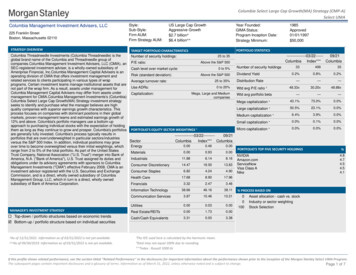
This stormwater management can protect life, property, and the environment, and subsequently improve quality of life for the citizens of Columbia. This manual is Columbia's initial attempt to prescribe state-of-the-art water quality and quantity protection practices for the Columbia area, based on current knowledge.