Transcription
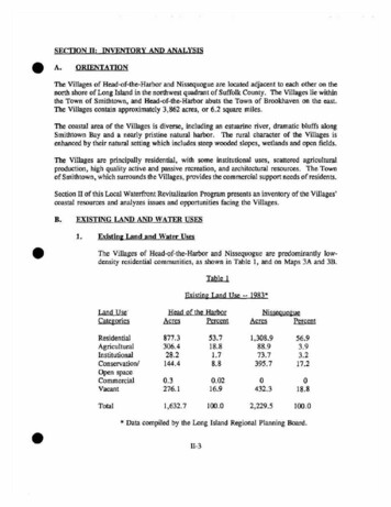
SECTION IT: INVENTORY AND ANALYSISeA.ORIENTAnONThe Villages of Head-of-the-Harbor and Nissequogue are located adjacent to each other on thenorth shore of Long Island in the northwest quadrant of Suffolk County. The Villages lie withinthe Town of Smithtown, and Head-of-the-Harbor abuts the Town of Brookhaven on the east.The Villages contain approximately 3,862 acres, or 6.2 square miles.The coastal area of the Villages is diverse, including an estuarine river, dramatic bluffs alongSmithtown Bay and a nearly pristine natural harbor. The rural character of the Villages isenhanced by their natural setting which includes steep wooded slopes, wetlands and open fields.The Villages are principally residential, with some institutional uses, scattered agriculturalproduction, high quality active and passive recreation, and architectural resources. The Townof Smithtown, which surrounds the Villages, provides the commercial support needs of residents.Section II of this Local Waterfront Revitalization Program presents an inventory of the Villages'coastal resources and analyzes issues and opportunities facing the Villages.B.EXISTING LAND AND WATER USES1.Existin& Land and Water UsesThe Villages of Head-of-the-Harbor and Nissequogue are predominantly lowdensity residential communities, as shown in Table 1, and on Maps 3A and 3B.Table 1Existing Land Use -- 1983*Land Use·CategoriesHead of the alAgriculturalInstitutionalConservation/Open 16.90432.3018.8Total1,632.7100.02,229.5100.0* Data compiled by the Long Islandll-3Regional Planning Board.
There are no high density residential areas in either Village. The averagedeveloped residential lot exceeds the principal required minimum lot size of twoacres which is established in both Villages' Zoning Laws. In Head-of-theHarbor, the average developed residential lot size is 2.7 acres, while inNissequogue it is 3 acres.A large proportion of the residential land is occupied by estates. In Head-of-theHarbor, estates account for 290 acres or 33% of the residential land. Two-thirdsof the estate property in the Village borders Stony Brook Harbor. InNissequogue, 40%, or 522 acres, of residential land is in estate holdings. Thebulk of the estates in Nissequogue are adjacent to either Stony Brook Harbor orto the Nissequogue River.The Villages are rather unique in western Suffolk County because they bothcontain active agricultural land. Head-of-the-Harbor retains over 306 acres ofagricultural land. Most of this land is along Fifty Acre Road and along Route25A, on the east side of the Village. Forty-five acres is permanently protectedunder the Suffolk County Farmland Preservation Program. This parcel, part ofthe Perry Farm, is located on Route 25A. Prime soils and favorable climate havemade production of field crops the predominant agricultural business in Head-ofthe-Harbor. Nissequogue has approximately 88 acres of agricultural land, whichaccounts for only 4% of its land area. This land is in horse farms.Institutional uses, such as churches, schools and municipal buildings,occupy arelatively small proportion of land in the Villages. In Head-of-the-Harbor, nearly28 acres are devoted to churches and parish houses. It also includes the HarborCountry Day School, a private, non-denominational elementary school onThompson Hill Road; the Mills Pond House on Route 25A run by the Town ofSmithtown as an historical site; and the Bay School House, located on MorichesRoad. Institutional land uses in Music Nissequogue amount to about 74 acres,almost all of which are owned by the Knox School, which is a private, nondenominational secondary school. This school has two major holdings, one in thesouthern part of the Village and the main one in the northeastern part of theVillage on Long Beach Road, adjacent to Stony Brook Harbor. Two smallinstitutional parcels are occupied by the fire department and the Village Hall.In both Villages, recreation and open space is a significant land use. There are144 acres of land in this category in the Village of Head-of-the-Harbor. Thisincludes 96 acres owned by the Nature Conservancy. The Nature Conservancyparcels are located on Shep Jones Lane and on the west side of Fifty Acre Road.The remainder of the recreational and open space land is wetlands owned by theVillage along Stony Brook Harbor and property owned by the Stony BrookFoundation and the Stony Brook Community Fund. It also includes a swim andtennis club and three small cemeteries. Nissequogue has over 17 % of its landarea in open space and recreational uses. The Nature Conservancy owns 130II-4
acres, most of which is north of Boney Lane and includes bluffs overlookingLong Island Sound. The Nissequogue Golf Club accounts for another 126 acres,overlooking Stony Brook Harbor. The Town of Smithtown is a majorrecreational land owner in the Village. The Town has 91 acres comprised ofShort Beach Park, a beach and dune complex at the mouth of the NissequogueRiver. The Long Beach Park is located on Stony Brook Harbor and providesmarina facilities. The Village's principal holding is a wildlife refuge on theeastern end of Long Beach peninsula.2.Water-Dependent and Water-Enhanced Uses/Public Access and RecreationThere are no commercial water uses in either Village. Neither the NissequogueRiver nor Stony Brook Harbor is suitable for any kind of commercialdevelopment. Navigational conditions and shallow depths exclude all but smallboats. Although the supply of fish is sufficient for recreational purposes,commercial fishing is precluded. Some commercial shellfishing is conducted ona very small scale and limited basis in Stony Brook Harbor; it is severelyrestricted in the Nissequogue River owing to water pollution. Water-dependentand water-enhanced uses are, therefore, almost exclusively recreational in nature.There are also some educational and scientific pursuits which occur in theVillages because of their waterfront location.Water-dependent recreation is broken into active uses and passive uses andactivities. The Villages themselves provide no active recreational facilities. TheTown of Smithtown owns and operates three active use facilities. Two are inNissequogue -- Short Beach near the mouth of the Nissequogue River and LongBeach on the northside of Stony Brook Harbor; and one at the boundary betweenNissequogue and Head-of-the-Harbor, at Cordwood Path. The Long Beach andCordwood Path facilities are located on Stony Brook Harbor. Long Beachprovides a swimming and bathing beach, picnicking, two boat launching ramps,a 167 slip marina, and mooring basin for 110 boats. Pumpout facilities havebeen installed and should be maintained and used. The shallow, quiet water atCordwood Path Beach draws families with young children. This beach ispartially artificial, and there are no other natural sand beaches on Stony BrookHarbor. The creation of additional sand beaches would severely impact theharbor's wetland habitats. Short Beach Town Park, located in Nissequogue at themouth of the Nissequogue River, provides a swimming beach with supportfacilities and a colonial waterbird preserve.aMotor boat speeding is a major problem in the harbor and the river. In areaswhere they should be travelling at five (5) mph, they have been clocked by radarat more than 60 mph. This poses safety hazards as well as environmental damageto wetlands caused by erosion and sedimentation resulting from vessel wakes andpropeller wash.II-5
;pnn :n."V "'"."(""):::lS."'" 0."roV :::l.'""'":::l'"orou.,ro ::::l ."'0"'"0'"n:::lVI "'0 "" .ro"".,roro.,'"." ro0--n.,.";p 0J.nS; :Jro'"0-ro"'t:.," "S'. I "'"0-. ---BI I II 0 ------ :;;" 0g;ti: '. --.-.,. -'-. -.- . . - '-- . --- - - - . . -----EXisti.og. l.an.d. U.seLocal Waterfront Revitalization ProgramVillage of Head-of-the-Harbor .T 1sIT'ap was prepared for ttle New York State Department of StateCoastal Managerrent Program with f1nandal asstshnce from theOffice of Ocean and Atmospheric Administration. provfdl!'d underthe Coastal Zone ManaqerrJ:!nt Act.o.f 1972, as amended.Federa 1 Grant II r: rlA-/lZ-AA- D-CZ068Cate of Prepara:t1on: February 1987
00'"V V "0a ----- .- --- :0 00 ::l 1" C"") 0 O::l"", I''" '" .,::lj". 1"e:j".::l' " 0 "'" M00::l 1"V '" ::l':':'"'":1. I rnU a '"V rro .00.'"::l 1" ::.,e: ZCJ.':':""811110EXisting Land UseLocal Waterfront Revitalization ProgramVillage of NissequogueThis map was prepared for the New York State Department of Stat{!Coastal Management Program with financial assist. nce from theOffice of Ocean and Atmospheric Administration, prov1ded underthe Coastal Zone Mana errent Act of 1972, as amended.Federal Grant Ph.rober: UA-R2-M-D-r.7.0figDate of Prep,8.Tat1on:I' ehruary 19117
The Villages do provide passive recreational opportunities. The Village ofNissequogue owns a 27 acre parcel at the eastern end of the Long Beachpeninsula. This area is used for nature study and a wildlife preserve. The siteis accessible only on foot.Both the Nissequogue River and Stony Brook Harbor are utilized for waterfowlhunting. Public access is provided at Short Beach Town Park on the NissoquogueRiver and at park areas on the west banks of the river outside of the Villages'LWRP boundaries.On Stony Brook Harbor, public access for walking, boating, fishing andwaterfowl hunting is available in the form of four public "landings", one inNissequogue (Smith Lane) and three in Head-of-the-Harbor (at the foot ofThompson's Lane, at Hitherbrook Extension and Shep Jones Lane Extension).These areas permit launching of small boats which are suited to harborconditions.Considering the low density of the Villages which allows for private recreationon most sites, plus the existence of the active recreation sites owned by the Townof Smithtown, there is little need for the Villages to develop active recreationalsites. Marina accessibility is very limited within the Town; however, Villagesponsorship of such a use would have probable significant adverse impacts onwetlands, water quality and habitats.Privately-owned water-related recreation includes the Smithtown Bay Yacht Club.Pumpout stations are not available and should be installed. There is also aprivately-owned beach club with access to Long Island Sound north of BoneyLane, east of Short Beach; both are in Nissequogue.While recreational facilities are extensive in the two Villages, and public accessso open, the number of persons attracted to the beaches and boating facilities isgreat enough to present a traffic problem especially on summer weekends. Anymaterial increase in active recreational areas would entail escalating costs not onlyin the provision and maintenance of road access, but in damage, possiblyirreversible, to valuable resource areas. For example, enlarging of beaches wouldentail an increase in erosion hazards, or destruction of wetlands, or both.Increasingly, the State University of New York at Stony Brook has begunexperimental studies in mariculture, clam and oyster rafting, lobster rearing, andrelated subjects, using the harbor as a living laboratory. The University has alsoconducted for some time studies of birds and wildlife based upon the inhabitantsof the wetlands surrounding the harbor, and of the nesting sites and sanctuarieson the Long Beach and Short Beach sand spit.11-11
3.Vacant Land and Land Available for DevelopmentThere are no sites which can be described as underutilized, abandoned ordeteriorated within the Villages of Nissequogue and Head-of-the-Harbor.However, the Villages do have large areas which are currently in agricultural,estate, private recreational or institutional uses which may, all or in part, becomeavailable for development. There are also numerous vacant lots, some of whichcan be further subdivided, in both Villages.The Suffolk County Planning Department did an analysis of land available fordevelopment in each Village in 1983 and 1984. The County's analysis, based onmaximum buildout under existing zoning, showed that the number of housingunits in each Village could potentially increa by 80-90% over existing numbers.According to the county studies, approximately 20% of the vacant land in eachVillage is in individual lots and is immediately available for construction. Theselots are scattered throughout the Villages. In Head-of-the-Harbor, 129 new.housing units could be built. One hundred seven new houses could be built inNissequogue.The large parcels, which are coming under increasing pressure to subdivide,include estate properties and farmlands. In Nissequogue, over one half of all landavailable for development is in estate and other large parcels. This amounts to522 acres. There are 283 acres of estate lands in Head-of-the-Harbor which canbe subdivided. Farmland is a more significant source of potential building lotsin Head-of-the-Harbor than in Nissequogue. Farmland is more likely to bedeveloped before estate properties because it is more easily developed and costsless per acre. This is a threat to continued agricultural production in the Villages.While not vacant or underutilized at the present time, the Nissequogue Golf Cluband the Knox School offer the potential for subdivision and development ofadditional housing units. Development of country club and institutional propertiesis occurring in other Long Island locations. Both properties have access to StonyBrook Harbor.4.AericultureAlthough the Villages are located in a rapidly urbanizing area, they retain animportant stock of agricultural land.II-12a,.,
In Head-of-the-Harbor, 12.9% of the Village area, or 210.6 acres of land, is stillactively farmed at the present time; of this, 45.6 acres, or 2.8% of the Village,is preserved under the Suffolk County Farmland Preservation Program. * InNissequogue, 3.9% of the Village by area, or 88.9 acres, is listed as inagricultural use, and is occupied by horse farms. Although much of the soil inthe Villages is the glacial morainal till typical of the north shore of Long Island,virtually all the remaining agricultural land is categorized as prime, and shouldbe preserved as an important resource.It must be noted, however, that farmland is disappearing in the Villages. Morethan 100 acres of land under cultivation in Head-of-the-Harbor were acquired fordevelopment in the period between October 1983 and October 1984, and by thepresent time nearly all of this has been developed for residential use. The DuboisSmith farm in Nissequogue, at the comer of Boney Lane and Horse Race Lane,recently was put up for sale.Eleven of the eighteen acres previously in vegetable crops will be converted. Theextremely high market value of building lots has created an enormous pressureto convert farmland, and no doubt the pressure will continue unabated. Theresources of private and public preservation programs are limited, and the risingfarmland prices strain these resources beyond their capacity to respond except inunusual, or unusually urgent, instances. Communities can rarely afford toacquire such valuable property by the exercise of eminent domain; farmlandpreservation typically is accomplished, outside of subsidized programs, by zoningto promote agriculture and open-space, and through such means as clusterdevelopment.5.Historic Structures. Sites. and DistrictsThe history shared by the Villages of Head-of-the-Harbor and Nissequogue islong, and is manifested In the preservation of an unusual number of identifiablesites and structures and other substantial material remains of the past. Extensivearcheological findings are connected with the original residents, members of theNissequogue or Nesaquake tribe, who maintained a permanent and major "royalseat" within the area of the present-day Village of Nissequogue. The records areThe preserved land, known as the Perry Farm, and lying between State Route 25A and Shep Jones Lane,is not only prime agricultural land, but is also geologically unique, and of great historic interest as landwhich has been continuously fanned for 300 years.II-13
especially rich along the Nissequogue River, where a complex cultural historygoing back more than 2000 years can be read, but the entire area of the presentday Villages provides frequent finds of artifacts. An Indian burial ground hasrecently been identified on the grounds of the Knox School; the high land at theextreme southern end of Stony Brook Harbor was once an Indian meeting orassembly place as well as a lookout point from which the approach of boats couldbe signalled. Fragments found in conjunction with clay deposits at two sitessuggest the existence of potteries. The presence of many tools and weaponsfashioned from non-local materials, including flint, provide an idea of the extentof cross-sound commerce and trade. Such remains are often turned up inexcavations for new buildings, requiring analysis and mitigation during theenvironmental review process.European settlement, commencing in the last third of the 17th century, isthoroughly recorded in remaining sites and structures. Richard Smith, Patentee(1613-1692), is buried in Nissequogue and many of the surviving old houses areconnected with Smith's sons or their descendants.In addition to early colonial structures, the Villages also contain important late19th century homes designed by prominent architects including Stanford White,Charles McKim, and the firms of Peabody, Wilson and Brown (ArchibaldBrown), Ford, Butler and Oliver (Lawrence Butler) and 1. H. Green of Sayville.Apart from significant individual structures and sites in both Villages, Head-ofthe-Harbor contains portions of three National Register historic districts locatedalong Route 25A. The three districts are, from east to the west, Mills PondDistrict and the 5t. James District; the North Country Road District is in foursections and surrounds the St. James District. For purposes of planning andarchitectural review, the Village of Nissequogue has designated the entire Villagea local historic area.The Villages are jointly proposing an extensive thematic National Register Districtembracing Stony Brook Harbor estates (c. 1690-1926) which is awaiting approval.Many of the houses in the proposed district are already listed on the NationalRegister.The lists, beginning on the following page, show those structures and sitesconsidered of importance in each Village.Sixty-four structures or sites of historic or architectural significance exist inNissequogue. Where important, the architects are identified.I1-14
SITES OF HISTORIC AND ARCHEOLOGICAL SIGNIFICANCEVILLAGE OF NISSEQUOGUEeeTax MapNumberStructure or SiteLocationDateJ. E. Petty House207 River Road1899801-007-3-11G. Petty House201 River Road1855801-007-3-11Boat Club199 River Road1900801-006-2-35Hawkins-Anderson HouseRiver Road1909801-007-1-11Wiedenkeller House (site ofHawkins house)River RoadMelvin house194 River Road1921802-11-1-3Adams-Bruemmer house195 River Road1873802-11-1-2Martin Taylor estate(Ford, Butler, Oliver)191 River Road1920802-11-1-1Osborne-Delafield house(McKim, Mead, White)River Road1914802-9-3-25Malcolm Smith house(Ford, Butler, Oliver)River Road1916802-9-3-2Caleb T. Smith estate Gate HouseHorse Race Lane1870802-9-3-1Caleb T. Smith-Hall estateHorse Race Lane1869802-9-1-12Howell HouseHorse Race Lane1800802-9-1-11Matherson-Lane estate(Arthur Little)Boney Lane1860802-1-2-2Lane Supt. House(Ford, Butler, Oliver)Boney Lane1913802-1-2-4Boney Lane1920802-1-2-1Lane Stable and Garage(Ford, Butler, Oliver)II-15802-11-3-4
Lane estate ice houseBoney Lane1901802-1-2-2Lane estate servants' houseBoney Lane1909802-1-2-1Nissequogue Point Beach, Inc.Boney Lane1920802-2-1-1Blodgett-Weld house(polhemus & CoffIn)174A Boney Lane1915802-8-1-11.4Caleb T. Smith cottageOff Boney Lane1870802-2-2-9DuBois T. Smith FarmOff Boney Lane1906802-2-2-9.3Tumure-Woody House(George P. Butler)Off Boney Lane1934802-3-1-1.1Harries tenant houseLong Beach Road1800802-9-2-1.1"Holly-by-Golly" Meserve HouseOriginal Richard Smith wingLong Beach Road1670802-9-1-6Berdell-Fletcher estateLong Beach Road1930802-3-1-1.2Berdell-Fletcher stablesLong Beach Road1930802-3-1-21Phyfe House87 Stillwater Lane1904802-3-5-1Raymond Sloan HouseLong Beach Road1939802-4-2-3The Knox School(peabody, Wilson, Brown)Long Beach Road1914802-3-3-1Seabury-Huntington HouseLong Beach Road1860802-5-2-1.1Wash HouseLong Beach RoadCarriage HouseLong Beach Road802-3-5-3E.T. Smith Fanner's QuartersMoriches Road802-9-1-18Superintendant's HouseMoriches Road802-9-1-20Harries bamMoriches Road1837802-9-2-1.1"New" Nissequogue School70B Moriches Road1937802-9-3-31II-16
eeeJob Smith homestead (Malone)69 Moriches Road1710802-9-2-2Old Nissequogue SchoolMoriches Road1808802-9-2-4Ryan estate-Niss. Golf Club(Bradley Delahanty)Moriches Road1930802-3-5-27.1Gade-Delafield house(William Delano)62 Moriches Road1926802-9-3-28.3"Dick-Nezer" Smith HouseSmith Lane1688802-10-1-2.3Reboul-Olney House"Woodcrest" (I.H. Green)Moriches Road1895802-10-3-6.1Lawson House(polhemus & Coffin)Moriches Road1926802-10-2-30Gorham-Paton House(Honohan)Moriches Road1930802-10-3-5.1Case-Whittemore-Windels"Harbor House"(Ford, Butler, Oliver)Moriches Road1930802-10-4.5Branglebrink-Hollandia Farm(Ford, Butler, Oliver)Moriches Road1880-1909802-12-1-3Butler-Schabert House"By-the-Harbor"(Charles McKim)Moriches Road1878802-12-2-12The "Casino" -Squash Court(McKim, Mead, White)Moriches Road1890802-12-2-13Butler Estate-OCtagonalin-ground water tankMoriches Road802-12-2-13Butler Estate- Superintendant'sHouseMoriches Road802-12-2-14Onet House(Ford, Butler, Oliver)Moriches Road1920802-10-4-9Boat HouseMoriches Road1920802-10-4-9II-17
Important archeological sites in the Village of Nissequogue include:Nissequogue Indian remains, James Creek Cove settlement and burial ground at RassapeagueKnox School site. Other Indian sites have been identified in Delafield Wood, and off BoneyLane."Bun" Smith cemetery, where the Patentee of Smithtown is buried.Site of the First Church on Moriches Road.The following natural areas are considered of significance to the Village of Nissequogue:Delafield WoodsOff River Road802-9-3-24"Whip Tree"Long Beach Road802-9-1-6Boldgett-Weld cabinOff Boney Lane802-2-1-6Pig Creek-natural areaLong Beach Road802-5-1-3-4,5Long Beach Barrier BeachLong Beach802-5;802-6Hubbs-Huntington PondMoriches Road802-12-1-15Short BeachMouth of the NissequogueRiverII-I8
SITES OF mSTORIC and ARCHEOLOGICAL SIGNIFICANCEin the VILLAGE of HEAD-OF-THE-HARBOReStructure or siteLocationDateTax MapNumberJ.L. Mallamo houseMoriches Roadc. 1860801-007-3-11Old butcher shopMoriches Roadc. 1860801-007-3--11United Methodist ChurchMoriches Road1898801-006-2-35Gibson-Sherman houseMoriches Road1888801-007-3-9Edgar L. Smith-Parke houseMoriches Road1890801-007-1-11T.P. Smith-Parke houseMoriches Road1877801-007-3-7George Newton houseMoriches Road1890801-007-3-6William Collier houseMoriches Roadc. 1900801-007-3-5Babcock-Hesse houseMoriches Road1936801-007-3-2Wetherill iron gates(Stanford White)(now at WetherhillLane)1898801-006-1-30"Box Hill" former main gates(Stanford White)Moriches Road1885801-006-1-25Lessard "Red Cottage"Moriches Roadc. 1840801-006-1-24L. White "White Cottage"Moriches Roadc. 1840801-006-1-22Deacon Hallock houseOfr Moriches Road1740801-006-1-26Captain Scott-Hubbs house10 Moriches Road1870801-007-1-11"Box Hill" appurtenances(Stanford White)Moriches Road1880-1906801-007-1-17,18,20Robert White house5 Moriches Roadc. 1840801-007-1-1911-19
"Box Hill" main house(1880-1906 additions - StanfordWhite)(1935 additions - Lawrence G.White)Moriches Roadc. 1840801-006-1-15Friends' Meeting House(Lawrence S. Butler)Moriches Road1908801-007-1-1-2.3Huntington cottage(Hubbs house)lOA Moriches Road1839801-007-1-1John Collier houseHarbor Hill Road1890801-006-2-24T. Farrell houseHarbor Hill Road1900801-006-2-33Skidmore-To Smith house30 Harbor Hill Rd.18301840801-006-2-32Walton cottage33 Harbor Hill Rd.1800801-006-2-16L'Hommedieu house35 Harbor Hill Rd.1858801-006-2-17Charles Smith-Daingerfieldhouse34 Harbor Hill Rd.1775801-006-2-27Paul Wepy houseHarbor Hill Road1790801-006-2-21Soper house and bottling works46 Harbor Hill Rd.1840801-006-2-20Bartlett house50 Harbor Hill Rd.1900801-004-2-6.1Capt. Selah Smith house60 Harbor Hill Rd.1840801-004-2-6.2Lottie Smith-Hubbard house57 Harbor Hill Rd.1835801-006-2-1Wetherill carriage house(Stanford White)18 Harbor Hill Wetherill house(Stanford White)"Shore Cottage" - Sayre house(Lawrence Grant White)3 Harbor Hill Rd.II-20
eeeStone pump house (ruin)(Stanford White)Harbor Roadc.1890801-006-1-31Trowbridge-Edwards house25 Harbor Road1937801-004-1-5Canning house29 Harbor Road1901801-004-1-3Capt. Obadiah Smith Giacolone houseHarbor Road1860801-0042-7.1Barton houseHarbor Road1890801-004-2-8.1Olyphant-Lefferts house39 Harbor Road1917801-004-1-8Emmet-Guenther house43 Harbor Roadc.1790801-004-1-7Townsend-Benkard house(William L. Bottomley)Harbor Road1931801-004-1-6Emmet-Bauer house61 Harbor Road1858801-004-1-6Becket house(William Huntington)Harbor Road1940801-002-117.4"Sherrewogue" gates(Stanford White)Harbor Road1895801-002-1-19"Sherrewogue" 1895 alterations(McKim, Mead & White)at Arbor LaneSculley houseHarbor Road1680801-002-1-14.1"Thatch Meadow Farm" houseHarbor Road1750801-001-1-1.1C.C. Lawrence house(J. Bradlwy Delehanty)Harbor Road1952801-001-1-3"East Farm" houseHarbor Road1710801-001-1-7Hawkins store/Coen houseHarbor Roadc. 1850801-001-1-3Wicks-Webber house178 Harbor Road1858801-001-1-4"The Mallows"(Charles Adams Platt)Harbor Road1906801-001-12II-21
Emmet appurtenant buildings(Stanford White)Harbor Road1906801-001-1-11C. Jayne houseHarbor Road1790801-001-2-6Grist millHarbor Road(Rebuilt)16991751801-001-1-28Blydenburgh houseSpring Street1844801-001-1-16Schaefer houseSpring Street1873801-001-1-28Williamson-Lorettz house23 Mill Road1837801-001-2-33D.T. Bayles Superintendant'scottageNorth Country Rd.1890801-001-2-33Sherry-Clarke houseIS Rhododendron Dr.·Windy Crest" - Creiger houseRhododendron Drive1800801-001-2-24Davis houseSaddle Road1790801-001-2-24StableSaddle Road19th c.801-001-2-16Perry farmShep Jones Lane1895801-003-3-5.2Freeman house52 Three Sisters Rd1900801-006-2-31E.M. Jayne house50 Three Sisters Rd1890801-006-2-30Old School(Stanford White)Three Sisters Road1890801-006-2-29Foy houseThree Sisters Roadc.19oo801-004-2-2-Perry houseThree Sisters Road1835801-005-2-18Jerome-Sykes house18 Three Sisters RdSnooks' houseThree Sisters Roadc. 1700801-005-2-24Harbor Country Day School(Lawrence S. Butler)Three Sisters 12eII-22
eeMills-Peck houseThree Sisters Road1865801-005-2-11Thornton house gatesThree Sisters Road1917at Farm RoadSuperintendent's house(peabody, Wilson & Brown)Pin Oak Lane1912801-004-2-24Thornton garagePin Oak Lane1913801-004-2-29Thornton guest house(peabody, Wilson & Brown)Pin Oak Lane1911801-004-29Abbott houseHitherbrook Road1865801-005-1-15Pabst-Rice house14 Fifty Acre Road19th c801-005-1-15Shields house; Butler estate50 Fifty Acre Roadc. 1890801-005-1-25Brennan-iselin house(Lawrence S. Butler)Fifty Acre Roadc. 1920Josephus Carman-O'Keeffe house54 Fifty Acre Roadmid-19 c.801-007-3-17Arvid Frank houseHighland Avenuec. 1900801-007-3-16Flinn house/St. James RectoryHighland Avenuec. 1890801-007-3-17E.W. Smith houseHighland Avenue1840801-007-3-12Tanaka-Cassidy houseHighland Avenuec. 1880801-007-3-14Allister Morris house(Lawrence S. Butler)Timothy Lanemid-1920s801-007-3028Kerr house(Lawrence S. Butler)Timothy Lanemid-1920s801-007-3-27Jonas Mills houseNorth Country Roadc. 1750801-005-1-24Jonas Mills barNorth Country Road1789801-005-1-23"Mills Pond House"(Calvin Pollard)North Country Road1838801-005-1-34.1"Mills Pond House" barnNorth Country Roadc. 1705801-005-1-34.8801-007-3-16II-23
"High Hedges"North Country Road1880801-005-1-34,10Lawson house(alterations - LawrenceS. Butler)North Country Road1855801-005-2-30"Deepwells"(from Minard Lafever book)North Country Road1847801-007-4-3"Timothy Stable"(Lawrence S. Butler)North Country Road1910801-007-3-22"Timothy House"(alterations-Lawrence S.Butler)North Country Roadc. 1800801-007-3-29"Crooked Cottage"North Country Road1900801-007-3-35G.H. Smith houseNorth Country Roadc. 1890801-007-3-32E.N. Smith houseNorth Country Road1908801-007-3-31Wicks houseNorth Country Road1886801-007-3-24.1Finn house441 North Country Rd. c. 190011-24801-007-1-3ee
eImportant archeological sites in the Village of Head-of-the-Harbor include:Site of Matthew Smith houseMoriches Road, Southeast corner Taylor LaneSite of Joseph Smith houseHarbor Hill Road near entrance to Bartlett HouseIndian shell heapsEast Side Harbor Hill Rd. adjoining large tidalmarshJacob's wellBartlett MarshFamily cemeteries:eMatthew SmithSouth side Moriches Road, just west of Taylor LaneWilliam Smith/CarmenWest side of Harbor Road near Wetherill house barnCharles SmithNorth of Harbor Road between Three Sisters Roadand Stony Brook HarborAdam SmithAt "Sherrewogue;" see aboveMillsWest of Mills Pond (Extensive; 80 graves)The following natural areas are considered of importance to the Village of Head-of-the-Harbor:Bartlett Inlet and MarshHarbor Road801-004-2-6Hitherbrook PondHarbor Road801-005-1-15Thatch MeadowHarbor Road801-001-1-1.1Kettle holesHarbor RoadMoriches RoadFifty Acre Road801-001-1-25801-007-3-7801-007-3-16"East Farm" preserveShep Jones LaneScenic Vista!11-25
6.ZonineMaps 4A and 4B show the current zoning in both Villages. In Nissequogue,there are two residential zones, R-2 (2 acres) and R-l (l acre). The R-2 districtcovers most of the Village. The R-l zone is confined to the Town beaches andthe dwellings on East Long Beach Road. Although the R-2 district has muchmore area than the R-l district, there are only 25 lots which do not conform tothe prevailing zoning compared
The remainder ofthe recreational and open space land is wetlands owned by the Village along Stony Brook Harbor and property owned by the Stony Brook Foundation and the Stony Brook Community Fund. Italso includes a swim and tennis club and three small cemeteries. Nissequogue has over 17 % of its land area in open space and recreational uses.