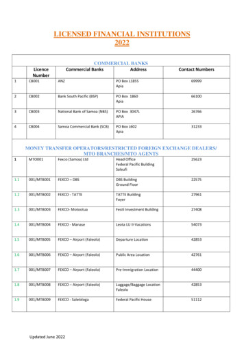
Transcription
Apia, SamoaClimate ChangeVulnerability Assessment
Apia, SamoaClimate ChangeVulnerability Assessment
Apia, Samoa - Climate Change Vulnerability AssessmentCopyright United Nations Human Settlements Programme (UN-Habitat)First edition 2014United Nations Human Settlements ProgrammeP.O. Box 30030, Nairobi 00100, KenyaE-mail: infohabitat@unhabitat.orgwww.unhabitat.orgHS Number: HS/037/14EISBN Number (Series): 978-92-1-132400-6ISBN Number (Volume): 978-92-1-132619-2DISCLAIMERThe designations employed and the presentation of material in this document do not imply the expression of any opinion whatsoever on thepart of the Secretariat of the United Nations concerning the legal status of any country, territory, city or area or of its authorities, or concerningthe delimitation of its frontiers or boundaries, or regarding its economic system or degree of development. The analysis conclusions and recommendations of this publication do not necessarily reflect the views of the United Nations Human Settlements Programme or its GoverningCouncil.Cover photo Bernhard BarthACKNOWLEDGEMENTSFunding for the Apia, Samoa - Climate Change Vulnerability Assessment was provided by the United Nations Development Account, and theCities and Climate Change Initiative.Principal Author:Planning and Urban Management Agency, Ministry of Natural Resources and Environment, SamoaContributors:Strategic Planning Section, Planning and Urban Management Agency, Ministry of Natural Resources andEnvironment, Samoa, and Apia Urban Area Communities.Reviewers:Bernhard Barth , Daphna Beersden, Liam Fee, Peter Grant, Ilija Gubic, Sarah Mecartney, Joris OeleCoordinators:Bernhard Barth (UN-Habitat), Ilija Gubic (UN-Habitat), Kirisimasi Seumanutafa (PUMA, MNRE)Editor:Peter GrantDesign and Layout:Deepanjana Chakravarti
Contents01Introduction02Overview of the Country and theApia Urban .9.4.2.9.5.The Country ContextDemographicsEconomic SectorGovernance StructurePhysical and Biological EnvironmentGeographic Location of Apia Urban AreaPopulationLand Use and Land TenureKey InfrastructureWater Supply and ityDrainage System03City-Wide Vulnerability - Assessmentof Key Climate Drivers in .3.7.3.3.8.Assessment FrameworkGeneral ClimateMain Drivers of Apia’s ClimateRainfallDroughtWindAir TemperaturesSea TemperaturesSea Level 0808090910101111111212121313
04Apia: Exposure and Sensitivityto Climate .4.5.6.4.5.7.Extreme Rainfall and Increased PrecipitationExposure to Sea Level RiseExposure to Tropical Cyclone and Storm SurgeExposure to FloodingSensitivity of Key Sectors and LivelihoodsTourismAgricultureSensitivity of Natural limate Change Hotspots5.15.2Hotspot Region 1: Gasegase River FloodplainHotspot Region 2: Vaisigano River Floodplain06Adaptive Capacity in 5.6.2.6.6.2.7.6.2.8.6.2.9.6.3Adaptation PlansCoastal Infrastructure Management Strategies and PlansNational Adaptation Program of ActionAdaptive Capacity at the City l SocietyCultureTourismAgricultureInformationA Risk Management Approach07Recommendations and 242425252727282828282829
List of FiguresFigure 1:Figure 2:Figure 3:Figure 4:Figure 5:Figure 6:Figure 7:Figure 8:Figure 9:Map of SamoaElevation Map of ApiaApia Land UseApia Water SupplyAssessment frameworkAnnual Rainfall in ApiaAnnual Mean Temperature in ApiaApia Hazard MapClimate Change Hotspot Areas in Apia030506070911121420List of TablesTable 1:Table 2:Economic Damage Caused by Previous NaturalDisasters in SamoaCommunity Perception of Vulnerability by Climate Risk1622
01IntroductionEarth’s climate has never been stable. Geological records demonstrate dramatic fluctuations in temperature occurring over millions of years. However, overthe last hundred years, the climate has been warmingas a result of human activities – a process referred toby scientists as ‘anthropogenic’ climate change, as itresults from the influence of human activity ratherthan natural cycles.Samoa is one of the nine countries chosen to undergoa Climate Change Assessment as part of the UnitedNations Human Settlements Programme (UN-Habitat)Cities and Climate Change Initiative (CCCI), in collaboration with the Commonwealth Local GovernmentForum (CLGF). The long term goal of the programmeis primarily to enhance climate change mitigation andpreparedness in cities by assisting local governmentsto develop climate change adaptation priorities, policies and awareness at all levels. However, in Samoa,there are two distinct tiers of governance. While thenational government operates through various centralized structures, it does not have designated local authorities. Instead, communities are managedthrough a traditional system of village councils whoare responsible for a range of public areas, such aseducation, health and other services.Samoa, like other Pacific Island States, is prone to natural disasters, most of which are weather and climaterelated, with floods, storms and wave surges associated with tropical cyclones being the predominant causes. Its tropical location exacerbates vulnerability, withextreme rainfall, temperatures and tropical stormsposing significant risks of flooding and storm surges.This vulnerability assessment therefore sets out tomeasure exposure, sensitivity and adaptive capacityto climate change in the city of Apia. It will identifylocal vulnerability to potential climate change impacts,drawing on the climate projections and experienceof recent natural disasters such as tropical cyclones,storm surges and flooding, as well as all relevant climate related studies conducted to date in Apia. Thisprovides a context for government decision makers toprioritize and design local adaptation and mitigationstrategies.Apia, Samoa - Climate Change Vulnerability Assessment01
02Overview of the Countryand the Apia Urban Area2.1 The Country ContextSamoa is a small island state in the southwest Pacific,comprised of four inhabited and six smaller, uninhabited islands located between latitude 13-150S and 1681730W longitude. It has a total land area of approximately 2,820 sq km. The two main islands of Upoluand Savaii, comprising over 95% of the land area, arecharacterized by rugged and mountainous topography. Samoa’s exclusive economic zone of 98,500 sqkm is the smallest in the Pacific region. Around 46 percent of Upolu and 70 per cent of Savaii is covered bysecondary and indigenous forest.2.2 DemographicsSamoa’s resident population from the 2011 nationalcensus was 186,340, with 20 per cent classified as living in the urban area in which the capital city Apiais located. The northwest of Upolu, when combinedwith Apia’s urban area, represents an area of only 311sq km or 11 per cent of the total land area, but over50 per cent of the population of Samoa. This has significant social and economic implications, given thegrowing number of people residing outside traditionalvillage settings and their associated governance structures. Between 70 and 80 per cent of the populationlive along or within a kilometre of the coast.Since independence in 1962, significant levels of emigration have slowed the overall rate of populationgrowth. The New Zealand quota scheme, which al-02lows 1,100 Samoans per year to gain permanent residency, is a major factor in the relatively slow increasein population, despite a high annual birth rate.Internal migration, especially from rural to urban areas, is likely to continue given the greater social andeconomic opportunities in Apia and the surroundingperi-urban region of North West Upolu. Furthermore,the increased availability of freehold land since the1990s, previously held as government property, isanother driver of recent urban growth. Samoa has afairly young population. Younger age groups are dominated by males, but over the age of fifty there tendsto be more women.Samoans make up 96 per cent of the ethnic populationof the country, with the remaining four per cent madeup largely of foreign short term workers. Less thanone percent of the national population are non-ethnicSamoans, but this group mostly have some form ofconnection to Samoa, either by marriage or througha relative. The average household size for the wholecountry in 2011 was 7.2 persons per household.2.3 Economic SectorSamoa has a relatively small but developing economythat has traditionally depended on development aid,overseas family remittances, agriculture, fishing andtourism. Fish and agricultural products are the mainexports, with the tourism sector developing in recentyears. Agriculture furnishes 90 per cent of exports,mainly coconut cream, coconut oil and copra. SinceCities and Climate Change Initiative
Figure 1: Map of SamoaAsauSavai’iSalelologaittraa ’uluaN30 Km15 KmReefSource: UN-Habitat1994, tourism earnings have been the largest sourceof foreign exchange and have grown significantlyfrom USD 40.6 million in 1999 to USD 107.3 million in2007. Samoa is one of the highest recipients of remittances in the world as a proportion of Gross DomesticProduct (GDP), typically fluctuating between 20 and25 per cent. Only around 12 per cent of Samoa‘s total population is engaged in formal paid employment.Two-thirds of Samoa‘s potential labour force is absorbed by subsistence village agriculture, a dominantsector in the Samoan economy.In 2014, Samoa graduated from the group of leastdeveloped countries and moved into the developingcountry group. This reflects its relatively large GDP percapita and its higher performance in other economic and human index indicators: over 95 per cent ofthe country has access to electricity, more than 97 percent to clean water and 98 per cent to a direct roadconnection. According to World Bank, in 2013 Samoahad GDP of USD 694.4 million, while its GDP per capita was USD 4,840. The main drivers for Samoa’s economy are the primary (ten per cent), secondary (22 percent) and tertiary sectors (68 per cent).Samoa depends on imported petroleum for much ofits energy needs. It is the government’s objective thatSamoa switches its reliance on fossil fuels to renewable energy in the near future. The Samoa EnergyPolicy aims to promote and encourage the use of renewable energy sources including solar, wind, coconutoil and urban waste. Currently, about 95 per cent ofSamoa has access to electricity, 32.8 per cent of whichis generated from hydro-electric power plants.2.4 Governance StructureSamoa has parliamentary democracy style governancemodelled under the Westminster system. The SamoanParliament is a unicameral legislative assembly madeup of 49 members of parliament with 47 MPs representing 41 traditional constituents and two MPs representing individual voters. Only matais (traditionalApia, Samoa - Climate Change Vulnerability Assessment03
chief titleholders) can stand as candidates for electionunder universal suffrage. However, Samoa does nothave local government systems, meaning all nationalmatters ranging from water supply, electricity, land,planning and infrastructure to village and individualmatters are managed by the national agencies.The 41 traditional constituents are made up of over300 traditional villages which are controlled by villagecouncils and protected by the constitution. The 1990Village Fono Act gives village councils (fono) authorityover village law and order, health and social issues.This traditional system provides communities with alocal governance structure managed by village councils represented by matais with hereditary connectionsand customary land ownership to the specific area. Inthe Apia urban area, some lands are under freeholdland ownership without the traditional councils. Inthese areas, with no systematic governance arrangements in place, local churches perform some dutieswhile the national government presides over all statutory matters. The main focus of the churches, however, is social issues and law and order. This puts pressure on the Planning and Urban Management Agency(PUMA), as the central government agency responsible n this area, to ensure environmental protectionand sustainable development.The Ministry of Natural Resources and Environment(MNRE) is the lead agency responsible for developingstrategies and policies in relation to climate changeand for overall implementation of national adaptationmeasures. Within MNRE, PUMA is responsible forstrategic planning and development in urban areas,as well as facilitating community consultation and issuing development consents. These require and environmental impact assessment and provide a tool tomanage building and construction, but currently arenot linked to defined activity zones or urban planningpriorities. In relation to Apia, PUMA is responsible forconducting the vulnerability and adaption (V&A) assessment and for implementing any plans which resultfrom it.2.5 Physical and BiologicalEnvironmentAll the islands of Samoa were formed by volcanic activity. Most soils were derived from basaltic volcanic04flows differing largely in age and type of deposit.The young volcanic structure of the island means thesoils are, in places, very porous for leaching into thegroundwater system.Approximately 50 per cent of Savaii and 40 per centof Upolu are comprised of steep slopes derived fromvolcanic activity. Both islands have central mountainridges formed from a chain of volcanic peaks and craters. In Upolu, the mountain range runs along thelength of the island with some peaks rising to morethan 1,000 metres above sea level, surrounded by flatand rolling coastal plains. Savaii contains a central coreof volcanic peaks reaching 1,858 metres at the highest point and encompassed by a series of lava-basedplateaus, hills and coastal plains. Approximately 80per cent of the 403 kilometre coastline is ‘sensitive’ or‘highly sensitive’ to erosion, flooding or landslip.Samoa was once completely covered by indigenouslowland and upland rainforests, with wetlands mostly along the coastal areas and mixed upland swampforest. Since the mid-1800s, when commercial farming operations were introduced, the native forestson Upolu were cleared for coconut and rubber treeplantations. Agricultural development since independence in the 1960s resulted in further forest clearingto make way for plantations, farms and logging operations across the country. In the early 1990s, majorcyclones - Ofa in 1990 and Val in 1991 - decimatedthe remaining indigenous forest stands to the pointthat the majority of Samoa’s forest is a mixture of secondary growth and disturbed forests. Upland Savaii’smontane and cloud forests were able to recover fromthe cyclones and remain the only undisturbed nativeforest left in Samoa, while all the forest on Upolu Island has been affected in some way.Five major common vegetation types are present inSamoa’s terrestrial ecosystems: littoral vegetation,swamp and herbaceous marsh, rainforest, volcanicvegetation, and secondary or disturbed forest. Forthe marine environment, Samoa is surrounded bycoral reefs, with sea grass beds, coastal marshlandsand mangrove forests bridging the intertidal zones.The marine biodiversity is common for tropical islands,although the biodiversity in Samoa is not as rich ordiverse as its neighbouring islands on the Western Pacific. While the smallness and geographical isolationof its islands have led to a high level of species en-Cities and Climate Change Initiative
demism, at the same time these factors have led toecological fragility, with many species having limiteddefenses against aggressive invasive species.2.6 Geographic Locationof Apia Urban AreaApia is located on the north coast of Upolu Island.The PUMA through its Act reform proposes the Apiaurban area (the City) as the four districts VaimaugaEast and West, Faleata East and West. The city is hometo at least 21 per cent of the total population with atotal land area of 61 sq km. It is characterized by anarrow, low lying, coastal plain with Mount Vaea andhighlands bordering the city in the south from east towest. The lowland is relatively flat and its elevation isnot more than ten metres above the mean sea level.Across the whole of Apia’s urban area lie the catchments of the six streams from Fagalii in the east to Fuluasou in the west. The Fagalii catchment is the smallest, occupying a narrow valley adjacent to the Vaivasecatchment. It has a total area of approximately 500ha. The two largest catchments are the Vaisigano andFuluasou catchments, each with a total area of 3,200ha with the Gasegase catchment the third largest at2,500 ha. The Mulivai and the Vaivase catchments areeach approximately 700 ha in area.There is significant pressure on the lower slopes ofthe watershed catchment areas as residential development of freehold land pushes into areas previouslyused for rural activities such as agriculture and forestry. The gently sloping land areas are mostly built up,while intense agricultural activities occur mainly in thehighlands.Figure 2: Elevation Map of ApiaElevation0m1m2m 4 mBuildingRoadSource: MNRE, SamoaApia, Samoa - Climate Change Vulnerability Assessment05
2.7 Populationthat of the working age group, around 54 per cent areemployed while the remainder are either in school orunemployed.The Apia Urban Area (AUA) population has declinedfrom 38,836 in 2001 to 36,853 in 2011. This reversesprevious trends and is thought to be caused by thegrowing population in the urban periphery, both inthe north western and the eastern region of Upolu.The total population of AUA now comprises 21 percent of the total national population. This figure rises to over 30 per cent when the peri-urban region ofNorth West Upolu is taken into account. If the wholeof North West Upolu is taken into account, 53 per centof the entire national population live in this region.The population density for AUA is 612 persons per sqkm, made up of 5,389 households. This is more thanten times the national average population density of60 persons per sq km. Of the AUA population, around60 per cent are of working age (15-59) while the other 27 per cent make up the under-14 age group. Ofparticular significance in this population breakdown isAUA has around 50 schools providing elementary,primary, secondary and tertiary level education. Although there is no specific data for Apia, the nationalliteracy rate for the 15-24 age group is 98 per cent.This is relatively high for a developing country and animportant element in public awareness and educationprogrammes.2.8 Land Use and LandTenureThe AUA is the only area of Samoa where freeholdland ownership is a significant feature. Only 29 percent of AUA households live on customary lands, com-Figure 3: Apia Land UsePortBuilt up area / MixedCommercial6Green ScapeAdministration /Tourism / Recreational5Commercial / Tourism1Vaea-Vaitele StreetIntersection2Town Clock3TATTE Building4FM FM I I Building5Samoa Port Authority6Parliament Building3241NSource: MNRE, Samoa06Cities and Climate Change Initiative
pared to 69 per cent of households in the country as awhole. However, there is a complete range of urbanland uses in each village area as families are grantedthe right to start businesses on their land. Each areathen contains wholesale, service and industrial activities, restaurants, tourism ventures as well as schools.Agriculture and forestry activities are scattered on thehighlands.changes occurred on an opportunistic basis ratherthan through planning.2.9 Key Infrastructure2.9.1. Water Supply and SanitationTo date, no proper land use plan has been developedfor Apia. PUMA, with the support of UN-Habitat, is atthe preparatory phase of its design. Since the arrivalof Europeans in the nineteenth century, Apia has developed as the main port and administrative centre,with some land converted from village ownership andland use to government and freehold land uses. TheseWater in Apia is supplied from the main urban catchments, with 65 per cent sourced from surface waterand 35 per cent from ground water. In addition tothe water supply network, which serves the majorityof the AUA, many family homes and buildings alsocollect rainwater through guttering around buildingsFigure 4: Apia Water SupplyNUrban PipeService Areas by Water SchemeU03: VailimaU08: VaileleU04: AlaoaU09: TapatapaoVillage Under IWSAU05: MagiagiU10: Fuluasou JRVillage Under SWAU06: Vaivase UtaIWSA PipelineCoastlineU07: Fagalii UtaSource: Samoa Water Authority, 2012Apia, Samoa - Climate Change Vulnerability Assessment07
which is stored in rainwater tanks for use when thenetwork is down during dry periods or after heavyrainfall. Furthermore, more than ten spring pools arefound throughout the AUA, used by families and businesses on a daily basis for drinking water, bathing andlaundry. These spring pools are also the main source ofwater for the area after cyclones when the water supply network may be down for two days to a month, aswas evident after Cyclones Ofa, Val and Evan.The final source of water for the communities aroundAUA is the four main river systems that flow throughit. When the river flow is clean, it is used by some ofthe families for washing and bathing when the waternetwork is down. Apia is served with a wastewatertreatment plant used mainly by the commercial sectorand multipurpose buildings. Septic tanks are used byalmost all households throughout AUA, while a verysmall percentage use pit latrines.2.9.2. TransportationLandThe city is connected with an improved road networkat critical locations. The key routes to Apia City are theWest Coast road, East Coast road and the Cross-Islandroad. All major urban road networks are sealed, butseveral key infrastructure elements such as footpathsand drainage systems need to be installed in areassuch as the central business area and roads close tothe coastline.AirThe Fagalii commuter airport is located on the easternside of Apia, below the hill top of Fagalii village. Theairport is paved and used for both domestic and international services, mainly American Samoa. The airportis a short drive from the Central Business Area and haslimited area for expansion because of the topography.SeaThe main port for Samoa is located in Apia Bay. It is themain exit of passengers to American Samoa and theTokelau islands by ferry. It also serves the main cargomovement into and out of Samoa. Apia Port recentlycompleted extension works and statistics indicate thatmore than 20,000 containers landed at the Port, witharound 20 cruise ships expected to berth during 2013.082.9.3. TelecommunicationsLandline and cellular/mobile telephone services areavailable throughout Samoa and broadband internetis currently being rolled out nationally. The headquarters of the telecommunications companies are locatedwithin the AUA, as well as the main television, cellphone and radio poles. These and other infrastructureare vulnerable to strong cyclone winds, while the mainradio communication pole and meteorology equipment on the Mulinuu Peninsular are also located onsea level rise and storm surge risk areas.2.9.4. ElectricityOver 95 per cent of Samoa’s population have accessto electricity, while within the AUA every householdand business has access. Electricity in Apia is sourcedfrom a combination of diesel and hydro-electric powergeneration systems. The hydro-electric dams in Afulilo, Lalomauga, and Alaoa generate around 36.8 million kWh annually, amounting to approximately 32.6per cent of national electricity needs. A supplementary396 kwh of solar power was also recently installed,with the development of an additional 4 mwh approved in Apia and Faleolo Airport to increase the renewable energy share. The majority of solar generatedelectricity will be located in the AUA, making it vulnerable to cyclones. Electric Power Corporation, thecountry’s supplier and distributor of electricity, recentlymoved the main diesel generators inland as part of itsupgrading and climate proofing activities.2.9.5. Drainage SystemApia has an extensive drainage system that is regularly upgraded as new roads and properties are built.Most of the drainage systems follow the river systemsof Gasegase, Mulivai, Vaisigano, and Fagalii. Due tothe continuous build up of new roads, properties, residences and office buildings, the drainage system hassuffered in that now most of the flooding is the resultof either blocked drains or natural waterways beingreclaimed. A recently completed Apia Spatial Plan isnow being used by the Land Transport Authority toupgrade and improve the drainage system, which willhopefully reduce major flooding around Apia duringheavy rainfall.Cities and Climate Change Initiative
03City-Wide Vulnerability Assessment of Key ClimateDrivers in Apia3.1 Assessment FrameworkA general climate change vulnerability and adaptationassessment has been chosen as the framework for thisstudy, where vulnerability is a function of exposure,sensitivity and adaptive capacity to climate change.As defined by the IPCC, adaptive capacity describesthe ability of a system to adjust to actual or expectedclimate stresses, while sensitivity refers to the degreeto which a system is affected, either adversely or beneficially, by climate–related stimuli. Exposure relatesto the degree of climate stress upon a particular unitof analysis. It may be represented as either long termchange in climate conditions or changes in climatevariability, including the magnitude and frequency ofextreme events.The main steps for completing Apia’s Vulnerability andAdaptation Assessment were as follows:t Determining the scope: identifying the geographic and sectoral focus of the assessment and the systems - natural, social, economic, institutional andbuilt - which will be impacted. This assessment, inline with PUMA’s definition of Apia’s urban area,includes four districts (Faleata Sisifo, Faleata Sasae,Vaimauga Sisifo and Vaimauga Sasae) due to theirpopulation composition and urban service infrastructure.t Conducting a baseline assessment: describingthe past and current context, including trends anddrivers across each of the identified systems. Thisinvolves gathering secondary data from key government departments and other relevant agencies, asFigure 5: Assessment frameworkSource: UN-HabitatApia, Samoa - Climate Change Vulnerability Assessment09
well as documenting individual accounts from certain communities.t Conducting an impact and vulnerability assessment: developing an analysis of the projectedclimatic threats to the target systems. The impactassessment combines the level of exposure and sensitivity of Apia city while identifying the city’s climate change hotspots.Samoa’s climate profile and climate change projections have been adapted from Climate Change in thePacific: Scientific Assessment and New Research, Volume 2: Country Reports.t Validating adaptation modalities and responses: integrating the assessment with initial consultation results and the outcomes of previous studies todesign integrated adaptation options and priorities.Infrastructure in ApiaPhoto Bernhard Barth3.2 General ClimateSamoa’s seasonal climate varies depending on thewet and dry seasons. On average, about 75 per centof Samoa’s yearly rainfall occurs in the wet season,between October and April, and this is accompaniedwith warmer air temperatures. By contrast, in the dryseason (May - September) Samoa experiences lowrainfall (only about 25 per cent of the annual volume)and cooler air temperatures.Temperatures range from 24 to 32 C and are generallyuniform throughout the year, with little seasonal variation due to Samoa’s near-equatorial location. Average annual rainfall is about 3,000 mm, with about 75per cent occurring during the wet season, and varyingfrom 2,500 mm in the northwest parts of the mainislands to over 6,000 mm in the highlands of Savaii.Samoa’s topography, particularly its mountains, alsoinfluences rainfall distribution. Wet areas are generallylocated in the southeast and the relatively drier areas –such as the Apia Urban Area - are located in the northwest. Humidity is usually high at about 80 per cent.Samoa experiences southeast trade winds for most ofthe year. Severe tropical cyclones occur from December to February. Samoa is also subject to anomalouslylong dry spells that coincide with the El Nino SouthernOscillation (ENSO) phenomenon. Several of these dryperiods have occurred over the last decade, together with several damaging tropical cyclones – which isconsistent with expected increase in variability due toclimate change.103.3 Main Drivers of Apia’sClimateSamoa’s climate is normally driven by the South PacificConvergence Zone (SPCZ) and El Nino Southern Oscillation (ENSO). The SPCZ adds to the intensificationof rainfall, especially during the wet season when itbecomes active. It is almost non-existent during thedry season, however, resulting in very dry rainfall conditions. It is a zone of wind convergence, cloudinessand rainfall that lies over Samoa in the wet seasonand retreats towards the equator in the dry season.As a result, Samoa receives more than three times theamount of rainfall in the wet season that it does in thedry season.ENSO is a natural phenomenon that occurs on a globalscale but mainly affects countries in the Pacific Ocean.ENSO has two phases - La Nina and El Nino - but alsoa neutral phase between the two. During a La Ninayear, Samoa experiences flooding in downtown Apiaas a result of extreme rainfall. The opposite occurs inan El Nino year. Drought and forest fires are most prevalent during the dry season in the northwest divisionof Savaii, due to the coinciding effects of El Nino suchas low rainfall and a prolonged dry season.Cities and Climate
List of Figures Figure 1: Map of Samoa 03 Figure 2: Elevation Map of Apia 05 Figure 3: Apia Land Use 06 Figure 4: Apia Water Supply 07 Figure 5: Assessment framework 09 Figure 6: Annual Rainfall in Apia 11 Figure 7: Annual Mean Temperature in Apia 12 Figure 8: Apia Hazard Map 14 Figure 9: Climate Change Hotspot Areas in Apia 20 List of Tables