Transcription
GEOG 482 / 582 : GISData ManagementLesson 9: ArcGIS Server Data ManagementGEOG482/582 / My Course / University of Washington
OverviewLearning Objective Questions:1. What is ArcGIS Server data management technology stack?2. What is UW Geography CGISE?3. What is the motivation for WAGDA 2.0?4. What technology stack is used to implement WAGDA dataLesson PreviewLearning objectivequestions act as thelesson outline.Questions beg answers.management at UW Libraries?GEOG482/582 / My Course / University of Washington
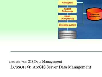
ArcGIS Server Data Management1. What is ArcGIS Server data management technology stack?ArcGIS Server is now marketed as ArcGIS Enterprise. ArcGIS Serversupports full-fledged data management software for the enterprise(i.e., large database systems) environment.ArcSDE stands for Arc Spatial Data Engine. The packaging of ArcSDEsoftware is different now that we have full-fledged ArcGIS Serversoftware. ArcSDE was originally an ‘installable’ middleware intoKey termsTechnology stackdesktop, which ‘connected’ desktop and server software products, butnow fully integrated into ArcGIS Desktop and ArcGIS Pro clients.Expanding over the years, ArcGIS Server software is now full-fledgedGIS software, with very similar capabilities as the standalone desktop,but it is MULTI-USER.Technology Stack – a layering of hardware and software components tocreate a system application environment such as a databasemanagement system. We focus on the software components.GEOG482/582 / My Course / University of Washington
Four layer software stack ArcGIS Server with PostgreSQL geodatabase technologyArcGIS software (ArcCatalog) Driver connections tospecific DBMS Specific DBMS for example, Linux See ArcSDE and PostgreSQL slides for further details about PostgreSQL stack.GEOG482/582 / My Course / University of Washington
ArcGIS Server in Geography2. What is UW Geography CGISE?The Geography Department has a server cluster that provides aCyberGIS Environment (CGISE).Cyberinfrastructure is a term used for data, software, and hardwareintegrated to offer remote (i.e., networked) processing capabilities.Thus, CyberGIS is a widely distributed GIS capability, often thought Key termsof as “high performance with distributed data”.Technology stackThe “high performance” part deals with much larger databases tosupport many users on remote server resources.Esri’s ArcGIS Server: basis of a CGISE deployed for Geography Dept.GEOG482/582 / My Course / University of Washington
Purpose of CGISEUW Geography Program1. Provide UW GEOG students with a collaborative geospatial informationcomputing environment that supports data management, analysis andmapping functionality.2. Serve as an operational environment versus the archival approach ofWAGDA through the UW Libraries as two different learningenvironments.1 & 2 imply full user access to ArcGIS Server to manage data & servicesCommunity Partner Data3. Serve as a regional node for Puget Sound Region GIS applications forresearch and education.Serving data management needs for 1, 2, and 3 point torequirements for system stability and robustness in a datamanagement environmentGEOG482/582 / My Course / University of Washington
Geog CyberGIS Environment (CGISE)GEOG482/582 / My Course / University of Washington
Enterprise Data from WAGDA to CGISE UW Libraries WAGDA (WA Geospatial Data Archive) hosts bothauthoritative data (from communities, agencies and institutions)and vetted derived data (from UW students & faculty). WAGDA is an “archive”, not an operational databaseenvironment. CGISE provides both a ‘working’ database and a repositorydatabase, collecting data from among multiple courses, whichcan be vetted and uploaded to WAGDA as a data archive (datawarehouse).GEOG482/582 / My Course / University of Washington
System Requirements - Data ManagementThree content types of GDBs are supported in Geography CGISE operationaldatabase environment:1. Partner (research/education) Project GDBsSeparate GDBs are created for partner projects, e.g., GDB’s that synergize theeducational activities in courses. Careful attention is given to administrativeresponsibilities for managing availability and veracity of database.2. Course (Student Project) GDBsSystem administrator creates a GDB, one per course, for use in courses. Allregistered students in the course are assigned as Data Managers.3. Puget Sound Region GDB (GISHUB)In order to persist the data from course GDBs, selected feature classes fromcourse (student project) databases will be replicated to GISHUB, together withWAGIC metadata. Students can read the database but do not have update anddelete privileges.WAGDA – a fourth data environment is outside the operational bounds ofGeography CGISE, but foundational to database activity as a campus-wide datawarehouse with potential connections to broader archives, known as spatial datainfrastructures – SDIs, like www.geoplatform.gov.GEOG482/582 / My Course / University of Washington
CGISE ApplicationWeb ClientsCGISEDesktop ClientsStatic: Web Map ViewerMap ServiceArcGISweb clientWFSArcGISDesktopLAN/RemoteInteractive: Web Map Editordraw points, lines, polygonsInteractive: Web Map Editordraw points, lines, polygonsArcGIS ServerArcDesktopLAN/RemoteAnalytic servies withinextensions to AGOLArcGISweb clientData Manager:Connect to project GDB andimport features, publish as WFS& map serviceArcDesktopLAN/RemotePostgreSQLData Manager:Connect to project GDBand import features publishGEOG482/582 / My Course / University of Washingtonas WFS & map service
Application Use Case – Multiple Generic ExamplesProject PurposesData management, analysis and display flood vulnerability bydrainage units (watershed, subwatershed and catchment)User RolesProject researchers, student researchers, and project analystsEnd Users Specific GIS Analyst (works with data analysis and map services)System Users Data Managers (load data in GDB, & manage permissions for DataEditors)FunctionalRequirementsData Management Store and serve drainage units with populationAnalysis Flood vulnerability for population by drainage unitMapping Puget Sound drainage units to be served by WAGDAA ‘real use case’ would be much narrower, focusing on one GIS user task only.GEOG482/582 / My Course / University of Washington
Database Mgmt User Roles & PrivilegesNOTE: Each feature class added to GDB is owned by user who added data (stored in their'schema'). For data to be visible to other GDB users, data owner must manage privileges ondata owned.DB Mgmt User RolesPrivilegesData ViewerGeneric 'read only' role to provide global access to dataData EditorRU operations on GDBData ManagerCRUD* on GDB. However, each dataset owner must assignprivileges on the dataset to other users (i.e. teammates) registeredin the system.System AdministratorFull access* CRUD Create, Read, Update, DeleteIn an ideal world, students would create their own GDBs. HOWEVER, creating GDBsrequires superuser privileges and the server license code. Sys Admin creates a courseGDB, and group databases. All registered students are assigned as Data Managers for thegroup databases. User creation is automated with UW Group Services.In Lab 4 students work as team on a single data collection, but each submit assignment.GEOG482/582 / My Course / University of Washington
WAGDA Overview3. What is the motivation for WAGDA 2.0?WAGDA 1.0 file-server download capability (now retired) System served web (html) pages with links to zipped files from adirectory or points users to external locations. Accessing data sets is a process that involves locating selectingfiles to download one at a time, unzipping, and storing files onKey termsWAGDAtheir local workstations (Google Search cannot index these files,which minimizes discoverability). Downloaded data can contain more data than necessary foruser which adds to download time and personal disk storage. Finding data descriptions (metadata) requires accessingadditional links and is a more cumbersome process whichimpedes the user’s determination of fitness for use.WAGDA 2.0 More convenient, manageable, and flexible solution was needed.GEOG482/582 / My Course / University of Washington
WAGDA 2.0 - Enterprise GIS data management offers Faster data search, quicker views to data, and decreases in localfile storage. Four types of users supported: Data readers Data contributors Data administrators Data editors Enterprise GIS data management system offers university datasuppliers an opportunity to disseminate data more readily withless maintenance using replication Spatial database system uses the ArcGIS Server suite. Services make data available in multiple and open formatsGEOG482/582 / My Course / University of Washington
Eight functional needs identified for Spatial Data Infrastructure Faster data viewing – Decreasing the amount of time andnumber of steps needed to view data sets in a GIS Remote data analysis –Only store analysis results or relevantextractions of larger data sets on local disk space. Exportable – Exposing source data to extract and save toconduct analysis and save their results. Interoperability – Providing data in non-ArcGIS and openKey termsAll those terms in boldformats to ensure the greatest accessibility and usefulness. Modifiable viewer permission –administrators to enforcemultiple permission policies laid out in data sharing agreements. Complete and ready metadata – Integrated metadata forcontributors and readers in communicating the nature of data. Database versions (historical and transactional) –databaseversions store data at certain points prior to updates to be made. Replication – Data producers can push data into the primarydatabase more quickly while maintaining data schema integrityGEOG482/582 / My Course / University of Washington
Data service connection Spatial Database Connection (SDBC) - connect users directly togeodatabase using ArcGlobe, ArcScene, ArcCatalog, ArcToolBox,ArcMap. Key termsGIS Server Publishing Services Geodata Service - basis for sharing data in open formatsusing Geographic Markup Language (GML) defined by OGC ServiceConnectionImage Service - raster imagery (elevation models, land cover,and orthophotos) served and viewed seamlessly fromgeodatabase Map Service - sharing data from basic, non-extractable viewsto open format data sharing with a predefined map image, forapplications like Puget Sound Nearshore EcosystemRestoration Project (PSNERP) databaseGEOG482/582 / My Course / University of Washington
Publishing services with open formats Web Mapping Service (WMS) – a view-only map service forcartographic display. Feature attributes cannot be viewed orqueried, nor can analysis be performed. No data export Web Feature Service (WFS) - vector data service suitable forquery, analysis, and extraction. WFS-T allows read-write accessfor editors with non-ArcGIS platform. Web Coverage Service (WCS) - raster data service suitable forKey termsWMSWFSWCSKMLquery, analysis, and extraction. Equivalent to Image Service butuses OGC specification. Keyhole Markup Language (KML) - service can display GoogleEarth or Maps. Can also use ESRI’s ArcGIS Explorer as analternative for performing basic query and analysis. KMLreaders available for most spatially aware applications, as it is anopen, XML-based format.GEOG482/582 / My Course / University of Washington
4. What technology stack is used to implement WAGDA datamanagement at UW Libraries?WAGDA uses Browser and Workstation connections from theapplication architectureWAGDA uses ArcSDE and PostgresQL to implement the technologystack for both geospatial DBMS and geospatial data archive.WAGDA 2.0 system configuration is on next slide.See UW Libraries WAGDA Overview slides for further details.GEOG482/582 / My Course / University of Washington
WAGDA 2.0 System Configuration OverviewGEOG482/582 / My Course / University of Washington
Systems ComponentsData Storage using PostgreSQL and ArcGIS (ArcSDE) ServerMetadata hosting using ArcGIS Server & (esri) GeoportalData discovery and dissemination using ArcGIS Server Services & GeoPortal All the data services available in ArcGIS Several services available Still considering if they are the the appropriate servicesGEOG482/582 / My Course / University of Washington
WAGDA Data LoadingHand off of data, loaded by library staff NAIP Aerial imagery Units of campusDirect database replication CSDE (Census Summary Files) Non-university organizations Operations (Operations, Capital Projects Office, etc.)GEOG482/582 / My Course / University of Washington
SummaryIn this lesson, you learned about 1. Enterprise Geodatabase technology stack2. UW Geography CGISE3. Motivation for WAGDA 2.04. Technology stack used to implement WAGDA data management at UW LibrariesGEOG482/582 / My Course / University of Washington
Contact me atnyerges@uw.edu if youhave questions orcomments about thislesson.GEOG 482/582: GISData ManagementEND Lesson 9: ArcGIS Server Data ManagementGEOG482/582 / My Course / University of Washington
Geography CGISE, but foundational to database activity as a campus-wide data warehouse with potential connections to broader archives, known as spatial data infrastructures -SDIs, like www.geoplatform.gov. . Data Storage using PostgreSQL and ArcGIS (ArcSDE) Server Metadata hosting using ArcGIS Server & (esri) Geoportal