Transcription
Integrated Mobile GIS and Wireless InternetMap Servers for Environmental Monitoringand ManagementMing-Hsiang TsouABSTRACT: With the progress of mobile GIS technology there is a great potential for adopting wirelesscommunications and Internet mapping services for regional environmental management programsand natural habitat conservation. This paper provides an overview of a NASA-funded research projectthat focuses on the development of mobile GIS tools and wireless Internet Map Server (IMS) servicesto facilitate environmental monitoring and management tasks. By developing and testing wirelessweb-based map/image servers, mobile GIS applications, and global positional systems (GPS), thisresearch created an integrated software/hardware infrastructure for a prototype mobile GIS application.The mobile GIS prototype allows multiple resource managers and park rangers to access large-size,remotely sensed images and GIS layers from a portable web server mounted in a vehicle. Users canconduct real-time spatial data updates and/or submit changes back to the web server over the wirelesslocal area network (WLAN). This paper discusses in general the major components of mobile GIS,their current technological limitations, and potential problems during implementation. Key researchagenda for mobile GIS are identified with suggestions for future research and development.KEYWORDS: Internet mapping, mobile GIS, GPS, wireless communicationMIntroductionany environmental problems andhabitat-monitoring tasks require nearreal-time field mapping and precisepositional information. These tasks are timeconsuming and difficult using traditional fieldmapping and geographic information systems(GIS) techniques (Angold et al. 1996), which areoften further limited to desktop computers andhard-wired network communications. Moreover,traditional GIS and remote sensing software packages are expensive, and they are perceived ascomplicated by field workers who lack advancedremote sensing and GIS skills or training. A possible solution is to adopt mobile GIS services thatcan integrate GIS, global positioning systems(GPS), and remote sensing capabilities for accessing geospatial data sets via mobile devices.There are many advantages to using mobile GISdevices for environmental management and habitatmonitoring. Field workers can easily carry mobileGIS devices to field locations for their data collectionand validation tasks. With wireless communicationcapability, users can perform real-time data updatesand exchanges between the centralized map serversMing-Hsiang Tsou, Assistant Professor, Department of Geography,San Diego State University, San Diego CA 92182-4493. E-mail: mtsou@mail.sdsu.edu .and distributed mobile clients. Another advantageof a mobile GIS solution is that the GIS frameworkcan be integrated with GPS equipment seamlesslyto provide comprehensive geodetic measurementsand navigation functions.Mobile GIS is an integrated technological frameworkfor the access of geospatial data and location-basedservices through mobile devices, such as Pocket PCs,Personal Digital Assistants (PDA), or smart cellularphones. With the advancement and convergenceof GPS, Internet, and wireless communicationtechnologies, mobile GIS has a great potential toplay an important role in field data acquisition andvalidation (Pundt 2002) and in emergency vehiclerouting services (Derekenaris et al. 2001). Todaythere is a rapidly increasing number of mobile GISapplications being established by private companies(Crisp 2003), government agencies, and academicresearch institutes.The main users of mobile GIS are field workersand consumers of location-based services (Peng andTsou 2003). For example, an environmental scientist in a national park can use GPS and mobile GISdevices to validate, add, or delete the locations ofsensitive plant species. A shopper can use a smartphone to locate a nearby shopping mall and createthe shortest routing path for navigation to it. A policeofficer can use a Pocket PC to report a traffic accident with accurate geospatial locations and sendthe report directly to the command and controlCartography and Geographic Information Science, Vol. 31, No. 3, 2004, pp. 153-165
center via wireless networks.Major Technologies used for Field-based GISMajor Applications for Field-based GISThese mobile GIS applica Environmental monitoring and natural Hardware: Pocket PC (WinCE), PDA (Palm OS),tions utilize different typesresource managementTablet PC (Windows based)of technologies, software Ecological/geographicresearch (field Software:MobileGIS/GPSsoftware(ArcPAD),packages, and hardwaredata collectionMapXtend), IntelliWhere, Onsite)devices. Sometimes they Utilities maintenance (electric, gas, Programming Tools: Java (J2SE or J2ME),are referred to by differentand water)Visual Basic, .NET compact Frameworknames, such as field-based Asset management systems (parcels, Wireless Communication: Wi-Fi or cellularGIS (Pundt and Brinkkotterlands)phone signalsRunde 2000), location-based Educational travel (field trips) GPS: External Blue-tooth or cable-linked Emergency response and hazardservices (LBS) (OGC 2003a;managementPeng and Tsou 2003), wireless GIS mapping (Xue et al.Major Technologies Used for LBSMajor Applications for LBS2002) and telecartography(Gartner 2003). Actually, Directory assistance (location-based Hardware: 3G or 4G mobile phones, smartthe differences in theseyellow pages, nearby stores orphones, or customized vehicle computerscommercial services)names reflect the compli- Software: Vendor-based systems with mobilecoding languages (WAP, C-HTML, Web clipping) Vehicle navigation (real-time trafficcated nature of mobile GISreport and routing functions) ProgrammingTools: Java (J2ME) and .NETapplications and the dra Business transaction servicesCompact Frameworkmatic progress of related(location-based transaction Wireless Communication: 3G or 4G cellularGIS/telecommunicationverifications, purchasing)phones or satellite systemstechnologies. The following Address query/mapping services GPS: Built-in with mobile phones or vehiclesparagraph provides a clear Geo-tracking services (package Web Services: Enterprise LBS serversdefinition of “mobile GIS”delivery, bus schedules, monitoring(providing client user subscriptions)and explains the differencesvehicle locations) Emergency response (911 calls)between the terminologies Real estate managementused in different mobile GIS Social interaction services (looking forapplications.friends and children, arranging dating)This paper defines themanagementterm mobile GIS as an integrated software/hardware Table 1. Mobile GIS applications and major technologies.framework for the accessof geospatial data and serTable 1 itemizes the major technologies used orvices through mobile devices via wireline or wirelessconsidered in field-based GIS and LBS and theirnetworks. There are two major application areas ofmajor application areas. In general, the field-basedmobile GIS: field-based GIS and location-based serGIS technologies emphasize the more comprehenvices. Field-based GIS focuses on GIS data collection,sive GIS functions, which require computationallyintensive devices and larger display screens, such asand data validation and update in the field, suchPocket and Tablet PCs. Most field-based GIS softwareas adding new point data or changing the attributepackages are cross-platform and independent oftables on an existing GIS dataset. Location-basedhardware devices. On the other hand, LBS techservices focus on business-oriented location managenologies focus on creating commercial value fromment functions, such as navigation, street routing,location information. Each mobile phone systemfinding a specific location, or tracking a vehicleor vehicle-based computer has its own proprietary(Jagoe 2002; OGC 2003b). The major differencesoperating system that is usually very difficult tobetween the field-based GIS and LBS are the datacustomize. To clarify the basic requirements of aediting capabilities. Most field-based GIS applicamobileGIS framework, the next section explainstions need to edit or change the original GIS datathegenericarchitecture of mobile GIS.or modify their attributes. Location-based servicesrarely change original GIS datasets but ratheruse them as the background or reference mapsThe Architecture of Mobile GISfor navigation or tracking purposes. Wireless GISmapping is a subcategory of mobile GIS technologyThe architecture of the mobile GIS is very similarthat focuses on the wireless networking capabilityto that of the Internet GIS. It follows the client/of mobile GIS services.server architecture as is traditional in Internet GIS154Cartography and Geographic Information Science
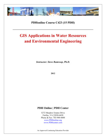
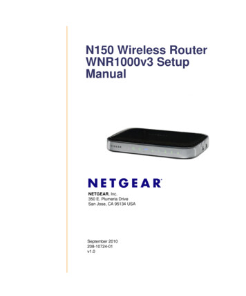
applications. The client-side mobile GIS components are the end-user hardware devices that candisplay maps or provide analytical results of GISoperations. The server-side components providecomprehensive geospatial data and perform GISoperations based on requests from the client-sidecomponents. Between the client and the serverthere are various types of communication networks (such as wired cable connections or wirelesscommunications) to facilitate the exchanges ofgeodata and services. Figure 1 illustrates the sixbasic components of mobile GIS: (1) positioningsystems; (2) mobile GPS receivers; (3) mobile GISsoftware; (4) data synchronization/wireless communication components; (5) geospatial data; and(6) GIS content servers.Positioning systems are the devices that can providegeoreferenced coordinate information (X, Y, andZ-elevation) to mobile GIS receivers. There are twomajor systems, local positioning systems and globalpositioning systems (GPS). Local positioning systemsrely on triangulation of the radio signals or cellularphone signals from multiple base stations in order tocalculate the position of a device. Global positioningsystems use satellite signals to calculate the positionof GPS units. Sometimes, mobile GIS applicationsmay require both types of positioning systems withinurban areas to generate satisfactory results.Mobile GIS receivers are small-sized computers orterminals that can display maps and locational information to end users. Their hardware componentsinclude CPU, memory, storage devices, input/outputconnections, and display (screen) functions. PocketPCs, smart phones, tablet PCs or PDAs are the mostpopular mobile GIS receivers. Notebook computerscan become mobile GIS receivers if connected toGPS and other mobile GIS components. However,most mobile GIS receivers require a very small-sizedhardware device to achieve portability. The majordifferences between small mobile GIS receiversand the traditional desktop personal computer aresmaller screen resolutions (240x300), limited storage space, and slower CPU speed (Wintges 2003).Some high-end mobile GIS receivers equippedwith wireless communication devices can be usedfor data exchange and telecommunications betweenthe receivers and the content servers. Alternatively,mobile GIS receivers may rely on serial or USBcables to transfer data between the content serversand the handheld devices.Mobile GIS software refers to the specializedGIS software packages employed by mobile GISapplications. Due to the limitations of mobile GISreceivers (smaller display units, limited storage),the design of mobile GIS software needs to focusVol. 31, No. 3on specific GIS operations (such as geocoding,address matching, spatial search, routing services,or map display) rather than comprehensive GISfunctions. For example, the functional design ofLBS software is quite different from the functionsprovided in field-based GIS packages. Most mobileGIS software packages are lightweight, customizable,and can cope with positional systems (such as GPStracking functions). Different mobile GIS softwaremay require different operating systems (such asWindows CE or Palm OS).Geospatial data are customized GIS layers or remotelysensed imagery used in mobile GIS applications. Withthe limited storage space in mobile GIS receivers,most GIS data need to be compressed or presentedas subsets of their original extents. Usually, mobileGIS receivers will store geospatial data in a geodatacache located in a temporary GIS storage space or aflash memory card. Often customized datasets aredownloaded and synchronized from GIS contentservers. One alternative approach is to utilize wireless communications to access large-sized GIS layersand/or remotely sensed imagery from the contentserver directly. The advantage of direct wireless accessis that mobile GIS users can retrieve the most up-todate geospatial information directly from the contentserver without encountering the complicated datasynchronization process between the mobile GISreceivers and the content servers.The data synchronization/wireless communication component is the communication mechanism linking themobile GIS receivers with GIS content servers. Theselinkages could be real-time wireless communications(via Wi-Fi or cellular phone signals) or cable-baseddata synchronization communications (via USB orserial ports). Both mechanisms should provide twoway communications. For cable-based connections,the GIS content servers can send geodata to thereceivers (stored in geodata cache) and the receivercan upload updated geodata back to the contentserver. For wireless communication, the mobile GISreceivers can request a specific service or map fromthe GIS content server, and the server will respond tothe request by sending the new map to the receiver.To facilitate the two-way communications, severalmiddleware or data synchronization software packages (such as Microsoft ActiveSync or Web Services)are required for mobile GIS applications. If bothmobile receivers and GIS content servers havenetworking capabilities, the Internet can becomea very effective communication channel for mobileGIS applications.GIS content servers are stand-alone GIS workstations or web-based servers that provide geospatialdata or map services to mobile GIS receivers. Most155
Figure 1. The architecture of mobile GIS.cable-based mobile GIS receivers use a stand-aloneGIS workstation as the content server. Wireless-basedmobile GIS receivers may require advanced webservers or wireless Internet map servers for accessing geospatial data. Sometimes, one mobile GISreceiver may be used to access multiple web-basedservers at the same time to integrate multiple GISlayers. A single GIS content server can also providedata and services to multiple mobile GIS receiverssimultaneously.Figure 1 illustrates a very generic mobile GISarchitecture. Different mobile GIS applications mayhave unique settings or additional components. Forexample, landscape architects may use a remotelysensed image as a background to draw a preliminarydesign of a tree line without the GPS component.Some sensitive data or classified mobile GIS operations may become stand-alone units without anyexternal communication mechanisms (for securityreasons). The next section introduces a mobile GISapplication for environmental monitoring tasks whichemploys a local wireless communication networkand a network-based mapping server.Developing Mobile GISfor Environmental MonitoringThe goal of this research is to respond to the needfor wireless, web-based analytical tools to process156remotely sensed imagery used by field participants in natural habitat conservation and landmanagement programs. The project focused onthe development of a mobile GIS architecture toprovide basic operational, user-friendly remotesensing capabilities to a diverse user communityof natural resource managers. Multiple resourcemanagement agencies, organizations, and commercial partners participated in this project,including: Mission Trail Regional Park at SanDiego, California; the Field Stations Office at SanDiego State University (SDSU); Ed Almanza andAssociates; and the Nature Conservancy of OrangeCounty, California.The project team developed a portable, wirelessweb-based image server integrated with mobilePocket PC and GPS receivers, and demonstratedreal-time GIS and remote sensing analysis capabilitiesin the field. Several user scenarios were developed todemonstrate the capability of real-time monitoringand the change detection tasks typically required innatural habitat reserves by resource managers. Themobile remote sensing and GIS data collection andanalysis solution provides a user-friendly, easy touse interface that allows park rangers and resourcemanagers to access and analyze land-cover changesand remotely sensed images in the field.The most unique feature of this mobile GIS application is the establishment of a wireless communication channel between an Internet map server (IMS)and a mobile GIS receiver. Currently, most mobileCartography and Geographic Information Science
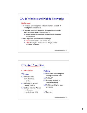
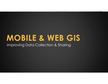
Figure 2. Wireless local area network solution for mobile GIS.GIS receivers (Pocket or Tablet PCs) provide verylimited storage capacity (64Mb to 128Mb) for fieldGIS applications. Wireless-based IMS can transfervery large remotely sensed images or extensive GISmap layers (up to 4GB or 8GB) to mobile devicesvia local wireless communications quickly. The linkto wireless IMS improves the capacity of mobile GISsignificantly. Multiple users can access a centralized IMS simultaneously without extra costs. Also,the IMS can allow multiple mobile GIS users tosynchronize their GIS databases at the same time,without the need to update GIS data layers andimages one by one.The following sections highlight the three majorelements of this project: mobile wireless local areanetworks, customized mobile GIS software and receiverdevices, and web-based GIS content servers.Mobile Wireless Local Area NetworksThe first and most substantial task of the projectwas to establish a wireless local area network forthe communications between mobile GIS receivers and Internet map servers. In the prototype,an Internet map server (ESRI ArcIMS 4.0) wasinstalled on a notebook computer (Toshiba Tecra8100) equipped with a wireless access port (LinksysWireless Access Point Router). The notebook andwireless access port were placed inside a vehicle toobtain electrical power from the cigarette lighterVol. 31, No. 3socket for wireless communications. Field staffthen used Pocket PCs equipped with GPS andwireless PCMIA cards to access remotely sensedimagery and GIS data layers from a large capacitydatabase residing on the notebook web server viawireless communication channels (Wi-Fi). Figure2 illustrates the architecture of the wireless localarea network solution of mobile GIS.Several possible technologies can be used for wireless data communication, including infrared, radio,microwave, and laser transmissions. The most popular techniques are infrared and radio signals thatcan be used to create Wireless Local Area Networks(wireless LAN). A wireless LAN refers to the use ofwireless communication technologies to connectPCs, laptops, printers, and hand-held devices totraditional hardwired networks over short distances(Jagoe 2002). For devices to communicate with eachother through a wireless media, a wireless networkadapter card with a transceiver must be installedin each device or computer. The transceivers act asaccess points through which signals are broadcastand received from each other. Currently, one of themost common wireless LAN infrastructures is theIEEE 802.11 (or Wi-Fi) technology.IEEE 802.11 specifies the physical and MediaAccess Control (MAC) layers for operation of wireless LANs. The 802.11 standard provides for datarates from 11Mb/s to 54Mb/s (Pandya 2000). Theterm, Wi-Fi, is the global brand name across all157
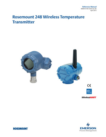
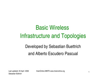
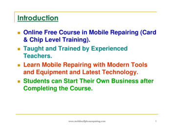
markets for any 802.11-based wireles LAN product.Many computers, PDAs, and printers have begun toadopt Wi-Fi—or IEEE 802.11 as their major communication channels. There are three extensions inthe 802.11 group technology which were consideredfor this project: 802.11.a provides up to 54 Mbps transfer rate inthe 5 GHz band (referred to as Wi-Fi5); 802.11.b is the most popular extension and canprovide up to 11 Mbps data transfer rate in the2.4 GHz band. Because of the different radiofrequency, 802.11b devices are not compatible(accessible) with 802.11a signals; and 80211.g provides up to a 20 Mbps data transfer rate in the 2.4 GHz band. Since the 11g and11b are using the same radio frequency, 802.11gdevices are backward compatible with 802.11bsignals.This research adopted the 802.11b Wi-Fi technology to create a wireless LAN for the mobile GISprototype. The wireless operating range of Wi-Fisignals is up to 100 m (300 feet indoors) or 500 m(1500 feet outdoors), depending on environmentalconditions. The wireless LAN in this prototype wasused to provide access to the mobile Internet mapserver and image web server installed on a laptopcomputer.One unique feature of this wireless mobile GISprototype is that the process of setting the Wi-Fi communication was solely Internet Protocol (IP) basedwithout relying on Domain Name Servers (DNS).Traditional web-based GIS applications utilize DNSfor the naming and searching of machines (such aswww.sdsu.edu or map.sdsu.edu). Since local wirelessnetworks do not have dedicated computers for DNS,all the units in the wireless network prototype wereaccessed and identified by their own IP addresses. Forexample, the IP address of the notebook web serverwas 130.191.118.58 and the Pocket PC IP address was130.191.118.56. The mobile GIS software package(ArcPAD) used in the project thus needed to specifyan IP address to access Internet map services (Figure3). The GIS users could also access the project website by typing “130.191.118.58” rather than typingDomain Name (i.e., map.sdsu.edu).Customized Mobile GIS Software andReceiver DevicesThe mobile GIS software used in our prototype isESRI ARCPAD 6.0. ArcPad is ESRI’s mobile mapping and GIS software, which runs on portablecomputers using the Window CE operating system(Pocket PC). ArcPad can be integrated with aglobal positioning system (GPS) and act as a client158to ArcIMS (ESRI 2002). The major challenge insetting up mobile GIS receivers is to create thelink between GPS devices and the Pocket PCs. Theresearch team tested two types of communicationmechanisms: a direct serial cable link and wirelessBluetooth connection. The first approach used aspecialized serial cable for the connection betweenPocket PCs and GPS devices. A potential problemwith this approach is that different Pocket PCsand PDAs require different types of cables, whichmay be difficult to obtain. Also, the portability ofthe hand-held units can be significantly reducedby the length and potential tangling of cablesbetween the two devices. The second approachwas to use a Bluetooth GPS card to connect to aBluetooth-capable Pocket PC. Bluetooth is a wireless radio-based technology for personal devicecommunications over short ranges (within 100meters). After comparing the two methods, theresearch team preferred the Bluetooth GPS configuration over the cable-based configuration.During the prototype testing, several basic GISfunctions, such as distance measurement and objectidentification, were performed using ArcPAD to illustrate the capability of mobile GIS. Figure 4 showsa series of screen shot images captured directlyfrom the Pocket PC using the ArcPAD toolbox. Thedistance measurement example was the distancemeasured between the SDSU parking structure andthe Geography Department building (102.8 meters).The research team also customized the ArcPAD userinterface to add new buttons designed for park rangersand environmental scientists using the ApplicationBuilder provided by ArcPAD. However, the researchteam experienced limitations in the existing GISfunctions provided in the ArcPAD Application Builder,especially in the low-level data communication andnetworking functions.This project utilized both cable and wireless communication mechanisms between the mobile GISreceiver and the GIS content server. During testing,GIS layers (roads, points of interest, ecologicallysensitive plants, park boundary) were downloadeddirectly from a GIS workstation via USB cable connections. Later, large-sized, remotely sensed imagerywas accessed from an ArcIMS server by ArcPad usinga TCP/IP connection over a wireless LAN. Also, anupdated GIS layer was uploaded back to the webserver directly via the wireless network.Another major customized client-side functionwas the creation of a real-time incident report andsubmission using the wireless environment. Weutilized the Pocket Internet Explorer and HTMLForm functions to create a field survey report withwhich we submitted field reports to a web serverCartography and Geographic Information Science
via wireless communication networks in near-realtime. Figure 5 shows the report form displayed onthe pocket Internet explorer with the submissionconfirmation.Beside the ESRI ArcPAD software there are other,commercially available mobile GIS packages, such asMapXtend from MapInfo and IntelliWhere LocationServer from Intergraph (Intergraph 2002). Due tothe limitations of research time and budget, ourprototype testing was limited to ArcPAD for ourmobile software testing.Web-based GIS Content Serverand the Implementation FrameworkThe project team created a web-based GIS content server by installing web server software andArcIMS 4.0 (ESRI 2001) on a notebook computer.The server components included a web server(Microsoft IIS 5.0) and an Internet map server(ArcIMS 4.0). The web server provided HTMLform functions for near real-time incident reporting as mentioned in the previous section. The webserver also acted as the middleware between theArcIMS server and the mobile GIS clients. ArcIMS(image map server) was used to provide Internetmapping services for the ArcPAD software via awireless LAN. Figure 6 illustrates the setting of theGIS content server on the notebook, which wasmounted in a vehicle or located with a portablebattery power station.The major challenge in setting up the portableGIS content server was providing an appropriatepower supply for the notebook computers andthe wireless access router. The research team used a300-watt power converter to convert DC power froman automobile cigarette lighter connection to two ACoutlets that were used to power a notebook computerand a wireless access router. The project team alsotested the mobile GIS prototype by utilizing a portable battery power station as the source of electricityto the mobile devices (Figure 6).Portable power stations have the advantage ofhaving compact configuration and better portability. However, a battery station can only supportthree to four hours of consecutive GIS operation,which may be a limitation for long-term field GISoperations. A vehicle-based power source can lastlonger than the portable battery power station.The research team tested the battery power sourceof a mid-size sedan which can provide five hoursof power support without restarting the engine ofthe vehicle. With the engine running, the vehicle’sbattery could provide longer power support forwireless routers and GIS units.Vol. 31, No. 3Figure 7 illustrates the actual implementationframework for the wireless mobile GIS prototypedescribed here. The framework follows a genericarchitecture of mobile GIS, with the server-side components being a GIS content server (notebook) andInternet mapping services (ArcIMS). The contentserver was connected directly to a Wi-Fi transceiverby a twisted pair ethernet cable. The Wi-Fi transceiver then broadcast the mapping services to, andreceived updated data from, the client-side components utilizing Pocket PCs with ArcPAD and PocketInternet Explorer software.The complete system is mobile and suitable forvarious types of field data collection, analysis andmonitoring tasks. All mobile devices were equippedwith GPS, GIS, and remotely sensed image displaycapabilities. To demonstrate the feasibility of mobileGIS in field applications, the project team createdseveral user scenarios and tested the prototype at aremote field location in the Mission Trail RegionalPark in San Diego. The next section highlightssome major tasks and findings derived during theprototype testing.User Scenariosand Prototype TestingThe purposes of the prototype testing were todemonstrate the capability of the wireless mobileGIS, to evaluate the feasibility of our prototypesystem, and to gather user feedback for futuresystem improvement. The criteria used in the prototype testing were: Proof of concept—to ensure the prototypesystem functions properly without failure; Usability evaluation—to evaluate whether theprototype can meet the needs of users; and Field agent review—to document end-usercomments and suggestions for improvementto the prototype design and system architecture issues.The following user scenario was a typical habitatmanagement task, which focused on detectingland-cover changes based on a real-time updateof GIS data.Test Date: January 15, 2003Task DescriptionMission Trails Region Park (MTRP) rangers and private sector environmental scientists used the PocketPC and GPS to perform a field mapping and GIS159
database updating task in order tolocate the presence of new invasiveplant infestations. This task is representative of habitat managementfieldwork. The target mobile GIStasks included: Connecting to the wirelessArcIMS Image server via WiFi connections from mobileGIS receivers; Reviewing severalchange detection images(MTRPchange) using mobileGIS software (ArcPAD); Adding new locations ofinvasive plants by using GPS;andFigure 3. IP-based Internet map server and web sites.Figure 4. The basic GIS function in mobile GIS software. Sending updated GISlayers (shapefiles) back tothe server via mobile FTPsoftware.Mobile GIS SolutionThe major goal of this scenariowas to demonstrate the functionality of real-time wireless dataupdate and GPS/GIS integration. A MTRP park ranger and aprivate sector environmental scientist participated as re
hard-wired network communications. Moreover, traditional GIS and remote sensing software pack-ages are expensive, and they are perceived as complicated by field workers who lack advanced remote sensing and GIS skills or training. A pos-sible solution is to adopt mobile GIS services that can integrate GIS, global positioning systems