Transcription
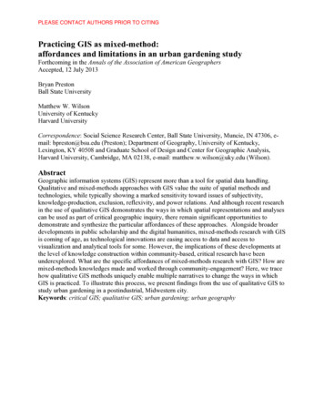
GIS - a mini intro GIS Geographic (spatial)Information System (computer based)GEOL 452/552GIS for Geoscientists I Based on relationships between tabledata (database) and locations on Earth Ask spatial questions: “Where is .?”,“What is the closest . ?”, “How many . ?”, etc. Use GIS analysis techniques to find spatial answers Visualize and communicate results (usually via a map)12Spatialquestions London 1854Geo located data:Location on Earthx water pump. Death from choleraData contained in polygonData Base (Excel spreadsheet)Distance?How many?Why?3(London, 1854, John Snow)4
Required Text: Mastering ArcGIS,Syllabus read the full syllabus (WebCT, paper) for details! Preparation for thesis work and advanced GIS courses(next semester: GIS for Geoscientists II) ESRI's ArcGIS 9.3 Desktop softwareFourth (4.) Edition from 2008 Course structure: 1 hour lecture (9:00 - 9:50) 10 min. break 1 hour lab/homework (10:00 - 10:50) you can stay longer (next class at 2 pm?)Course goal: Introduction to GIS operations andanalysis in a geoscience contextGeol552 (but not Geol442) counts as part of the“Foundations of GIS” requirements for the GIScertificate: hp5Abbreviations: ch chapter, rq review questions, ex exercise, tut tutorial, HW homework, p page mid middle of page(Tuesdays yellow)17 One full book chapter per week: first half on Tues., second half on Thurs.Preparation (you): First day of class:Plan for Semester (prelim.)Lecture (9:00 - 9:50) 6Geol 454/552 Fall 2009 Plan (for MGIS 4. ed)Read full chapter material before classAnswer review questions for chapterLecture: only go over “most important” materialYou will get paper handouts - use them to make notes!Your notes: most of the permanent value the class willhave for you 15-Sep817-SepChapterCh 11- CoordinateSystems7 - GeoprocessingSyllabus, course overview,Chcomputernetwork/file-server setup, WebCT setup(former(HW 0) Ch 8)Syllabus etc.Ch 1 - GIS DataCh 2 - Mapping GISdataCh 3 - Presenting GISData(former Ch ctMidterm v(former Chs 11/12)Ch 8 - Raster Analysis(former Ch. 15)24-Nov(possible unemploymentmap Challenge ex.?)Ch 6 - Spatial Joins(former Ch 6)hand in mprj3, quiz 3XThanskgiving26-NovXThanskgiving271-DecXWork on class283-DecXWork on class298-DecBreak (Project)Ch 5 - Queries(former Ch 5)hand in mproj 22517-NovQuiz 1 ArcScene ,start mproj 1(TBA: GeoDBs,2619-NovNetworks, Project, ?)-10 USGS pape1927-Octclass exercise: draw map(possiblegradedand tables for 2 layers 3 cities (name, pop) in2029-Oct2 states(name)Ch 12/13 - EditingCh 4 - Attribute Data720-OctLecture (1hr)1822-Octhand in mproj 1Class ProjectReview for FinalReview for Final3010-DecProjectPresentationsMidterm review,start mproj2Midterm(15 TBDmin Multiple Choice 60min31Finalpractical)Final: 15 min Mpractical8
Lab exercises (10:00 to 10:50) Three types of practical exercises: Textbook tutorial (step-by-step, not graded) Homework exercises (2 - 4 textbook ex., graded) Project work (mini project, class project, graded) TA (Nick Vreeland) myself are here to help youwith practical exercisesHomework exercises Short answers to exercises and tutorials are alreadyin the book (pages 573 - 583) BUT: I want want detailed solutions: text, numbers,screenshots with homework! (part of grade) Start after lecture, ask us (me, TA), group work OKHand in via Web CT (book exercises, projects only)Time given for: homework exercise:1 weekmini project: 2 weeks9Tests and grading Three mini-projects : 20 homework assignments: up to 4 pts. per exercise,typically 2 - 4 ex. (15% / 20% of grade )Midterm, Final test ( 20 - 25 % each) Larger exercises, material of previous, 3 weeks15%/10% of grade Final projectOpen book: can use textbook your notes (!) Multiple Choice part (15 min.)Practical part (60 min.)2 quizzes (open book, 10%) 1020 min to answer 3 of 4 questions (write text)11Poster (only electronic form needed!) 10 min. oral presentation (powerpoint)Material: up to you (your research?)Gr. 20%, UGr. extra credit12
Introductions Participation: 10% Extra points for lecture feedback (WebCT) Best/Worst of last lecture Clearest/Muddiest point of last lecture What I learned today / What I didn’t get at all Intelligent question about materialInstructor – Chris Harding Masters Degree in Geology (Geoinformatics) Worked for Lynx Geosystems (Vancouver, Canada)writing GIS software, Oil & Gas companies (Exxon, Shell) Ph.D. in Geology from University of Houston Associate Professor Geoscience Department Contact info: charding@iastate.edu, tel. 4-4868,Offices: 1620 Howe HallOffice hours: by appointment1314GIS lab setupYour turn, tell us: Log in with your usual ISU id password In case of problems, for now use : Major ? Advisor ? Thesis project ? Prior GIS involvement ? Why are you taking this course ?Name ?Username: !gtlluser Password: ask me Network connection to GIS server\\delphi.gis.iastate.edu\GEOL552 From outside the GIS lab:read Connecting to GIS delphi server (WebCT)1516
Web CT quickoverviewLet’s test Web CT access Open web browser (firefox) atwww.iastate.edu Home page (house icon): current items Announcements: Changes, reminders Assignment: Homework exercises Calendar: See what’s due tests Discussion: lecture feedback Rest: Web Links, My Grades Click webCT (lower left) Login to WebCT Gold with ISU netID From course list select Geol 452-55217 Notice the coordinatesGoogle Earth 18of the point (lower middle part) Now try: Mount Saint HelensStart it now (Desktop Shortcut)Under Search (upper left), enter a place (Ames,IA) and hit enterActivate only these layers (types of information): Terrain Roads Borders Populated places Navigation: upper right partpan (left mouse),rotate, zoom (wheel), tilt (middlemouse) left-click/drag on “blobs”: eye rotate,hand move 19fly with arrow keys20
Change timeLab exercise (HW 0):(light): Press Sunbutton, movesliderWhere do/did you live outside of Ames ? Task: Create a Google Earth (.kml or .kmz) file ofa placemark Find of a place outside of Ames where you once Try later: Manhattan Island, Chicago (3D buildings on),lived (e.g., where you go during breaks?). Find this place in GoogleEarth (Use Search) andGrand Canyon, Mt. Everest, .add a placemark (Press the Pin icon). For now: let’s start on today’s lab (HW 0)21Until Thursday’s lecture: Enter your Name and write a short description of Get "Mastering GIS" Book (4. ed.! ) Read Intro and chapter 1 to p. 24 Read Syllabuswhat this place means to you In Google Earth, find your entry under Places (MyPlaces). Now right-click on this entry (a pull-downmenu appears) and save-as my-name .kmz Extra Point: What’s the coordinate of this place?On Thursday:(Latitude, Longitude, Elevation ) 22 Lecture: GIS exampleIn WebCT attach the saved kmz file to yourassignment, press submit Lab:23World’s largest easter eggChapter 1 Tutorial24
GEOL 452/552 GIS for Geoscientists I 1 GIS - a mini intro GIS Geographic (spatial) Information System (computer based) Based on relationships between table data (database) and locations on Earth Ask spatial questions: "Where is .?", "What is the closest . ?", "How many . ?", etc. Use GIS analysis techniques to find spatial answers