Transcription
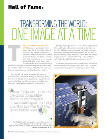
Hall of FameTRANSFORMING THE WORLD:ONE IMAGE AT A TIMETHEY SAY OPPORTUNITY DANCESWITH those who are already on thedance floor. But, if you are Dr. Walter S.Scott, you find a way to make opportunity dance with you even when your footis broken! The year was 1991 — one dayafter Scott’s bachelor party. His marriagewas to take place in two weeks. AndScott was holed up in his room nursing abroken foot following an impassioned game of paintball withhis best friend. This down time gave Scott time to work on abusiness plan he had been thinking about for a while.Satellite imagery proved to be a key factor during the ColdWar, enabling the US to make decisions based on fact, notfear. “The GIS industry was emerging, computing costs weregoing down, Internet had been introduced, and the government was mulling letting the private sector enter the satelliteimaging business. I remember thinking — why can’t thesetechnologies be applied to a broader group of users?”Scott never went to business school and he didn’t haveany experience formulating business plans. “But, I knew thisexercise wherein you prove how stupid your idea is. AndThe Cold War had ended. The world was set for atransformation. “I remember thinking at the time that anytime there is change, there is opportunity,” says Scott, whowas then handling top defense projects at the LawrenceLivermore National Laboratory in the United States.We are fortunate that trendslike cloud computing,machine learning andcrowdsourcing are enablinganalytics in a way that wasnever before possible The QuickBird satellite was the first in a constellation of sub-meterspacecraft that DigitalGlobe developed to offer highly accurate,high-resolution commercial satellite imagery of Earth. It was launched in2001 and decommissioned in 201564 GEOSPATIAL WORLD JANUARY/FEBRUARY 2017 WWW.GEOSPATIALWORLD.NET
WALTER SCOTTFOUNDER, DIGITALGLOBE TOBOLDLY GOWHERE NOPRIVATECOMPANYHAD GONEBEFOREWWW.GEOSPATIALWORLD.NET JANUARY/FEBRUARY 2017 GEOSPATIAL WORLD 65
Hall of FameDID YOUKNOW?DigitalGlobe sawtwo monumentalfailures andnearly a decadeof heartacheand frustrationbefore itsuccessfullyput a satellite upin spaceif by the end of the exercise, you can’t prove it is stupid, it might actually be worth doing,” he quips.WorldView Imaging Corporation was created in January 1992 — seven months before the Land RemoteSensing Policy Act was enacted.WorldView Imaging went on to become the first private business to receive a high-resolutioncommercial remote sensing license under the landmark 1992 Act. Scott’s vision in creating and nurturing WorldView Imaging brought a marked shift in overall drive towards scalability and utility in spaceindustry. Nonetheless, getting the company off the ground was no easy task. Rome imagedby WorldView-2in December2009: Caracallaarchaeological area,with its impressivethermae, appears inthe left part of theimage; the FAO whitebuilding is towardthe right On November 11, 2016,DigitalGlobe’searth observationsatellite WorldView-4launched fromVandenberg Air ForceBase in California.Lockheed Martinbuilt the satellite.WorldView-4 offers30cm satellite imagery– the highest resolutioncommercially availableIn a span of seven years, WorldView Imaging sawtwo massive failures. “We blew up our first satellite,EarlyBird-1. The second, QuickBird-1, was a launchfailure,” Scott sighs. “For several years, I was living off mywife’s income. We had become famous as the companyknown for blowing-up most remote sensing satellites.Luckily, I had a very supportive board of directors, and anequally supportive group of investors.”Then came October 2001, when QuickBird-2 went upsuccessfully. The company, which had reorganized itselfas DigitalGlobe by that time, started offering the world’shighest-resolution commercial satellite imagery. It hasnever looked back since.66 GEOSPATIAL WORLD JANUARY/FEBRUARY 2017 WWW.GEOSPATIALWORLD.NET
WALTER SCOTTFOUNDER, DIGITALGLOBE Ringing the bell: OnDecember 15, 2009,executives and guests ofDigitalGlobe visited theNew York Stock Exchangeto commemorate thecompany’s initial publicoffering on the NYSE onMay 14, 2009 Scott is an avidtriathlete. After acouple surgeries,now he is only allowedto cycle“I wouldn’t saythe dream cametrue overnight.I would say thatsome of the biggest barriers to thedream finally wentaway by havinga satellite in theorbit. It was amazing to be able tosit at the satellitecontrol centre andsee on the screenpictures thatwere taken fromthe other side ofthe planet a fewminutes ago,” saidScott.Now came thepart where theteam had to figureout how to makemoney. “It turnedout putting thespacecraft into theorbit is actually theeasy part. Buildinga business outof it is when theheavy-lifting happens. You couldn’tgo to governmentsand businessesand say: ‘Hey, lookthere some reallypretty pictures fromspace!’ At best, itwould mean thesepeople would hangthem on their wallsas artwork. Theneed was to actually connect themwith the value ofthese images, andshow them howthey can use theimagery to savelives, resources andtime.”WWW.GEOSPATIALWORLD.NET JANUARY/FEBRUARY 2017 GEOSPATIAL WORLD 67
Hall of FamePutting a spacecraft into theorbit is the easy part. Buildinga business out of it is wherethe heavy-lifting happensKey partnerships with big customers, including Google andMicrosoft, for location-based services and mapping applications poured in over the years but, not without intensecompetition from firms like Space Imaging, which operatedthe IKONOS satellite.In 2003, the National Imagery and Mapping Agency wasinviting bids for its prestigious NextView contract, intendedto spur development of commercial imaging satellites. At thetime, Space Imaging was Goliath, and DigitalGlobe was seenas David. To the surprise of the industry, DigitalGlobe won thefirst contract. David had beaten Goliath, and Space Imagingwas soon up for sale and absorbed by rival firm GeoEye.The NextView contract helped DigitalGlobe develop anddeploy the revolutionary WorldView-1 satellite in 2007.Scott had put the company’s trajectory well in advance ofthe competition. “WorldView-1 was a dramatic step-up incapability, and in retrospect, was really the first commerciallyviable remote sensing system. The investment we made in theWorldView constellations was delivering dramatically greatervalue per dollar than was being delivered by the GeoEyeconstellations.” The Jane GoodallInstitute utilizedDigitalGlobe’s satelliteimagery to makeeffective conservationdecisionsEventually, in 2013, the two companies merged makingDigitalGlobe what it is today. What followed that mergerwas the launch of WorldView-3, providing the highestresolution satellite imagery commercially available. In 2016,DigitalGlobe followed it up with the launch of WorldView-4,thus increasing its capacity for 30cm resolution imagery.“WorldView-4 is not encumbered to provide imagery for the Scott giving aspecial plenary sessionon ‘Remote Sensingand the Impacton Sustainability’at AmericanGeographical Society,November 201668 GEOSPATIAL WORLD JANUARY/FEBRUARY 2017 WWW.GEOSPATIALWORLD.NET
WALTER SCOTT FOUNDER, DIGITALGLOBE Left: Young Scott in a chemistry labTop: After satellites and imagery,sports is what excites ScottFor several years, I was living off my wife’s income. We hadbecome famous as the company known for blowing-upmost remote sensing satellites Scott was chosenas Esprit’sEntrepreneur of theYear 2003. In thisnews clipping, Scott isseen holding a modelof the company’ssatellite that deliveredhigh-resolution imagesof specific areasaround the globeWWW.GEOSPATIALWORLD.NET JANUARY/FEBRUARY 2017 GEOSPATIAL WORLD 69
Hall of FameUS government. That has enabledus to offer priority access to othercustomers. It’s a purely commercially-driven satellite,” Scott said.DID YOUKNOW?More than abillion peoplearound the worlduse navigationmaps poweredby DigitalGlobe’simagery to getfrom Point A toPoint B Top:WorldView-4’s firstpublic image, takenon November 26,2016features the YoyogiNational Gymnasiumin Shibuya, TokyoRight: The PearlIsland in Qatar, asimaged by QuickBird70 GEOSPATIAL WORLD JANUARY/FEBRUARY 2017 WWW.GEOSPATIALWORLD.NETLooking ahead, Scott, predictsradical changes to come in howimagery is processed. “I have seen aset of enablers that have emergedin the last few years that have madeanalytics on a very large scale suddenly possible. One of them is cloudcomputing. The second enabler is theemergence of machine learning algorithms that are now sophisticatedenough to be trained to recognizeobjects. The third enabler is crowdsourcing. We are fortune that thesekind of trends are enabling largescale machine analytics in a way thatwas never before possible.”What also excites Scott is sports.An avid triathlete, Scott has kept hisorthopaedic surgeon busy with acouple of shoulder surgeries, a kneesurgery and a hip surgery. “Now, I’monly allowed to do cycling when I’mnot taking meetings. I find it helpsme keep my mind clear.”It has been over a quarter ofcentury since the Cold War ended.In those 25 years, DigitalGlobe hasbeen a leading innovator in the commercial satellite industry, monitoringhow the world has changed andleading to greater global transparency. Today, more than a billion people around the world use navigationmaps powered by DigitalGlobe’simagery to get from Point A to PointB. The company’s customers rangefrom urban planners, to conservation organizations like the AmazonConservation Team, to US federalagencies like the National Geospatial-Intelligence Agency (NGA). Overthe years, DigitalGlobe’s imageryhas helped prevent atrocities, warcrimes and humanitarian crises. Ithas helped transform our world —based on facts, not fears.
26.11.2016 · broken foot following an impassioned game of paintball with his best friend. This down time gave Scott time to work on a business plan he had been thinking about for a while. The Cold War had ended. The world was set for a transformation. “I remember thinking at the time that any time there is change, there is opportunity,” says Scott, who