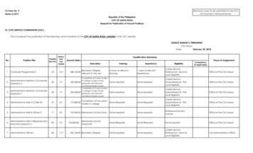
Transcription
THE PHILIPPINEDISASTER RISK REDUCTIONAND MANAGEMENTSYSTEMMs. JANICE MONTES PADAGDAGCivil Defense Officer IIOffice of Civil DefenseDepartment of National Defense (OCD-DND)ADRC Visiting Researcher Program 2018BKobe, Hyogo, Japan
2C O N T E N T SI. General InformationII. Philippine Disaster Risk ProfileA. Natural HazardsB. Recent Major DisastersIII. Philippine DRRM SystemA. Salient Features of Republic Act 10121B. NDRRM FrameworkC. NDRRM PlanD. Four DRRM Thematic AreasE. National Disaster Response PlanF. National Disaster Preparedness PlanG. Harmonized National Contingency Plan forMagnitude 7.2 EarthquakeH. ChallengesIV. ADRC Counterpart
3Country Report of the PhilippinesI.General InformationThe Philippines, located in Southeast Asia (SEA), is one of the largestisland groups in the world with 7,107 islands and islets lying about500 miles (800 kms) off the coast of Vietnam. Outstanding physicalfeatures of the Philippines include the irregular configuration of thearchipelago, the coastline of some 22,550 miles (36,290 km), thegreat extent of mountainous country, the generally northward trend ofthe river systems, and the spectacular lakes. The islands arecomposed primarily of volcanic rock and coral, but all principal rockformations are present. The archipelago has a total land area of120,000 sq miles (300,000 sq km) and stretches about 1,150 miles(1,850 km) from north to south, and its widest east-west extent, at itssouthern vase, is some 7000 miles (1,130 km).It is further divided into three (3) major groups of islands namely,Luzon, Visayas and Mindanao. Luzon is the biggest island groupwhile Visayas is a melting pot of Spanish, Chinese, and Indo-Malayancultures; and Mindanao where Chinese and Muslims are predominant.There are 17 administrative regions, namely: National Capital Region(NCR); Ilocos Region (Region I); Cordillera Administrative Region(CAR); Cagayan Valley (Region II); Central Luzon (Region III);CALABARZON (Region IV-A); MIMAROPA (Region IV-B); BicolRegion (Region V); Western Visayas (Region VI); Central Visayas(Region VII); Eastern Visayas (VIII); Zamboanga Peninsula (RegionIX); Northern Mindanao (Region X); Davao Region (Region XI);SOCCSKSARGEN (Region XII); Caraga Region (Region XIII); and,Autonomous Region in Muslim Mindanao (ARMM). Figure 1 belowillustrates the map of the Philippine Islands.Manila is the capital city but outside Manila there are also diversecenters of commerce and industry, culture, the arts, and education.Meanwhile, Quezon City is the largest and most-populous city. Thecountry has a total population of 100,981,437 based on the 2015Census of Population (POPCEN 2015). The Filipino is basically ofMalay stock with a sprinkling of Chinese, American, Spanish andArab blood, and other ethnic minorities. The system of Governmentis Democratic with our current President, His Excellency RODRIGOROA DUTERTE.
4Figure 1. Map of the Republic of the PhilippinesThe climate of the Philippines is tropical and maritime. It ischaracterized by relatively high temperature, high humidity andabundant rainfall. It is similar in many respects to the climate of thecountries of Central America. Temperature, humidity and rainfall arethe most important elements of the country’s weather and climate.Based on the average of all weather stations in the Philippines,excluding Baguio, the mean annual temperature is 26.6o C. Thecoolest months fall in January with a mean temperature of 25.5oCwhile the warmest month occurs in May with a mean temperature of28.3oC.
5Rainfall is the most important climatic element in the Philippines.Rainfall distribution throughout the country varies from one region toanother, depending upon the direction of the moisture-bearing windsand the location of the mountain systems.The mean annual rainfall of the Philippines varies from 965 to 4,064millimeters annually. Baguio City, Eastern Samar, and EasternSurigao receive the greatest amount of rainfall while the southernportion of Cotabato receives the least amount of rain. At GeneralSantos City in Cotabato, the average annual rainfall is only 978millimeters.Using temperature and rainfall as bases, the climate of the countrycan be divided into two major seasons: (1) the rainy season, fromJune to November; and (2) the dry season, from December to May.The dry season may be subdivided further into (a) the cool dry season,from December to February; and (b) the hot dry season, from Marchto May.Based on the distribution of rainfall, four climate types are recognized,which are described as follows:Figure 2. Climate Map of the Philippines based on the Modified Coronas Classification
6II.Philippine Disaster Risk ProfileA. Natural Hazards Likely to Affect the Country (Featuresand Tendency)The Philippines is prone to almost all types of natural hazardsbecause of its geographical location and geotectonic setting.Figure 3. Map showing the Pacific Ring of FireIn addition, the Philippines is situated along the highly-seismic PacificRing of Fire as shown on Figure 3. This is the area where thePhilippine Sea and Eurasian Tectonic Plates meet and is prone tooccurrences of earthquakes, tsunamis and volcanic eruptions. In fact,there are 300 volcanoes in the country and 22 are active.Figure 4 shows the distribution of active faults and trenches in thePhilippines which are found in several areas of the country.
7Figure 4. Map showing the Distribution of Active Faults and Trenches in the PhilippinesMoreover, Figure 5 presents the seismicity or the frequency ofoccurrence of earthquakes, almost all parts of the country experienceearthquakes. Generally, we encounter an average of 20 earthquakesa day, per latest figures from the Philippine Institute of Volcanologyand Seismology (PHIVOLCS). Earthquake disasters are not as
8frequent as the typhoons and flooding that take place in thePhilippines.Figure 5. Map showing the Seismicity of the PhilippinesNevertheless, the impact generated on affected communities isusually massive and devastating. Earthquake-induced disasters werefew in numbers and in terms of casualties. According to the AnnualReport by the PHIVOLCS, in 2017, six (6) damaging earthquakes hitthe country commencing with the magnitude 6.7 earthquake inSurigao del Norte on 10 February. A series of earthquakes wererecorded in Mabini, Batangas Province from April to August 2017. A
9major event in the earthquake swarms had a magnitude of 5.5 on 04April. Two (2) more strong earthquakes occurred on 08 April, the firstwith magnitude 5.6, succeeded by another with magnitude 6.0. On 12April, a magnitude 6.0 earthquake occurred with epicenter near Wao,Lanao del Sur. On the 29th of the same month, a magnitude 7.2earthquake happened offshore of Saranggani, Davao Occidental. On25 May, a magnitude 5.4 earthquake happened near the vicinity ofSan Marcelino, Zambales. Lastly, Ormoc City, Leyte and vicinity wereshaken by the magnitude 6.5 earthquake on 06 July (PHIVOLCSAnnual Report, 2017). The strong ground shaking subsequentlycaused liquefaction, earthquake-induced landslides, and damages tobuildings and other infrastructures. Areas transected by the activefaults that moved and generated the earthquakes were also affectedby ground rupture.Aside from being situated in the Pacific Ring of Fire shown on Figure6 below, the country is also located along the Pacific Typhoon Belt.This explains the occurrences of different weather disturbances suchas typhoons.The Philippine Atmospheric, Geophysical andAstronomical Services Administration (PAGASA) reports that everyyear, an average of twenty (20) tropical cyclones enter the PhilippineArea of Responsibility (PAR) and five (5) of which shall be mostdestructive. Tropical cyclones and its sequential effects of rain andwindstorms, as well as floods are the most prevalent types of hydrometeorological hazards in the country.Figure 6. Photo showing Pacific Typhoon Belt
10In fact, the Philippines can also be called “Exporter of Typhoons”.Figure 7 below illustrates the tracks of Tropical Cyclones in theWestern North Pacific Period from 1948 to 2010 based on the recordsof the Japan Meteorological Agency (JMA).Figure 7. Tracks of Tropical Cyclones in the Western North Pacific Period from 1948 to 2010Between 1997 and 2007, eighty-four (84) tropical cyclones enteredthe Philippine Area of Responsibility (PAR). These typhoons resultedto a total of 13,155 in human casualty and more than 51 millionfamilies have been affected. Economic losses due to typhoondamages in agriculture, infrastructures and private properties areestimated to reach P158.242-B. Some of the most devastating floodsand landslides are triggered by these typhoons that happened alsowithin this period. The El Nino Southern Oscillation which is a periodicdisaster recorded high economic costs in just a single occurrence. In2010, out of the almost PhP 25-M worth of damages to propertiescaused by natural disasters, tropical cyclones contributed to morethan half. These affected more than 3 million people in that year alone.As shown on Figure 8, the intensity scale classification of tropicalcyclone by the Philippine Atmospheric Geophysical and Astronomical
11Services Administration (PAGASA), have developed the category forSuper Typhoon, with sustained winds of greater than 220 km per hour.In the past years, the country does not have the category for SuperTyphoon. However, because of Typhoon Yolanda, the PAGASA hadthe realization that the strength of typhoons can go beyond thecountry’s existing threshold.Figure 8: PAGASA’s Tropical Cyclone Intensity ScaleIn addition, Philippines also has to contend with the irreversibleimpacts of climate change that is characterized by the increasingglobal temperatures as illustrated on Figure 9.Photo credit: Google ImagesFigure 9: Schematic Presentation showing Climate ChangeAmongst these natural hazards, the Philippine government has todeal with internal disputes and threats of terrorism in some areas
12making us also vulnerable to this kind of political and human-inducedhazards.Environmental factors such as denuded forests aggravate flood risks.The pace of deforestation since the 1930s accelerated in the 1950sand 1960s, before falling slightly in the 1980s. Even now, the effectsof loose soil and reduced forest cover from past forestry activities arefelt in frequent landslides and floods. Recent events show that theannual monsoon season in the country has brought severe floodingin most areas.Based on the data from the National Disaster Risk Reduction andManagement Council (NDRRMC), a total of 302 natural incidentswere monitored for the period CY 2014-2017 as seen on Figure 10below.Figure 10. Natural incidents monitored for CY2014-2017
13Of the natural incidents monitored, flashfloods topped the list with 119or 39.2% incidents followed by landslides with 29 or 9.6% and tornadowith 28 or 9.2%.B. Recent Major Disasters:1.Naga Landslides (September 2018)A landslide incident occurred in Sitio Sindulan, Barangay Tinaan,Naga City, Cebu. The City of Naga was declared under State ofCalamity thru Resolution No. 001-A-2018 on 21 September 2018 dueto damages brought by the occurrence of a massive landslide. Itaffected 1,972 families or 8,252 persons in barangays, with 77 dead,7 injured and 57 missing.2.Typhoon Mangkhut (September 2018)Typhoon Mangkhut, locally known as Typhoon Ompong entered thePhilippine Area of Responsibility (PAR) on 12 September 2018 andhas made landfall in Baggao, Cagayan on 15 September 2018. Thetyphoon caused widespread damage across Northern and CentralLuzon due to its intense nature and large size ( 900km). Interactionwith the rugged terrain of Northern Luzon have aggravated the natureof rainfall, which caused flooding and landslides especially in themountainous Cordillera Administrative Region. It affected a total of730,596 families or 3,029,062 persons in 5,917 barangays with 82dead, 138 injured and 2 missing. It destroyed 210,500 houses anddamaged a total estimated amount of P7.2B on infrastructure andP26.8B on agriculture.3.Volcanic Activity (January 2018)Mayon Volcano (Bulkang Mayon), alsoknown as Mount Mayon, is anactive volcano in the Province of Albay.Mayon is the most active volcano in thePhilippines having erupted over 49times in the past 400 years.
14On 13 January 2018, a phreatic eruption occurred in Mayon Volcano.Per PHIVOLCS Eruption Notification, the estimated height of grayishash plume is at 2,500 meter that drifted towards the Southwest.Traces of ashfall were found in the Municipalities of Camalig,Guinobatan, Daraga and Ligao City.DOST-PHIVOLCS raised the alert status of Mayon Volcano from AlertLevel 2 (increasing unrest) to Alert Level 3 (increased tendencytowards hazardous eruption). This means Mayon was exhibitingrelatively high unrest and that magma is at the crater. On 16 January2018, the Albay Province was declared under the State of Calamitythru Resolution No. 00670-2018. NDRRMOC raised the alert statusfrom Blue to Red and conducted continuous monitoring andcoordination with other member agencies and response clusters.On 22 January 2018, PHIVOLCS raised the Alert Level of MayonVolcano to Alert Level 4 (hazardous eruption imminent). The DangerZone was extended to 8 kilometers radius from the summit vent. Thepublic was strongly advised to be vigilant and desist from entering thisdanger zone. Civil aviation authorities advised pilots to avoid flyingclose to the volcano’s summit as ash from eruptions can behazardous to aircraft. A total of nine (9) international flights andsixteen (16) were cancelled due to volcanic activity.Then, on 6 March 2018, a notice for lowering of Mayon Volcano’sstatus from Alert Level 4 (hazardous eruption imminent) to Alert Level3 (decreased tendency towards hazardous eruption).On 07 March 2018 as per Situational Report no. 57 issued by theNDRRMC, a total of seventy-six (76) volcanic earthquakes andthirteen (13) rockfall events were recorded by Mayon’s seismicmonitoring network. Sulfur dioxide emission was measured at anaverage of 4,459 tonnes/day on 06 March 2018. Deflation of the lowerslopes that began on 20 February is still being recorded by electronictilt and by Precise Levelling (PL) surveys.A total of 16,380 families were pre-emptively evacuated in Region Vdue to Mt. Mayon phreatic eruption. A total of 23,705 families / 90,742 persons were affected in 61 barangays in the municipalities/cities of Bacacay, Camalig, Guinobatan, Ligao City, Daraga, TabacoCity, Malilipot, Santo Domingo (Libog), and Legazpi City in theProvince of Albay (Region V).
154.Typhoon Hagupit (December 2014)Typhoon Hagupit, locally known as Typhoon “Ruby” entered thePhilippines on 4 December 2014 at 4:00AM with maximum winds of175kph and gustiness of 210kph and is moving West Northwest at25kph. Typhoon Hagupit is being compared to last year’s SuperTyphoon Yolanda that also enters PAR on the last quarter of the year.A total of 944,249 families or 4,149,484 persons were affected inRegions III, IV-A, IV-B, V, VI, VII, VIII, CARAGA and NCR. Therewere 18 fatalities and 916 injured persons and damaged 290,670houses. Furthermore, it damaged infrastructure and agricultureamounting to Php5,090,265,462.00.5.Super Typhoon Yolanda (November 2013)Super Typhoon Haiyan, locally known as Typhoon Yolanda enteredthe Philippine Area ofResponsibility PAR on 6November 2013 and madelandfall on (1) n, Cebu; (4)Bantayan Island, Cebu;(5) Conception, Iloilo; andfinally (6) Busuanga,Palawan and left the Photo-credit: rappler.comPhilippines on 9 Nov2013.The wrath of “Yolanda” affected a total of 3,424,593 Families or16,078,181 Persons in 12,139 Brgys in 44 Prov, 591 Mun, 57 Citiesin the Regions of IV-A, IV-B, 5,6,7,8,10,11 & Caraga. A total of1,140,332 houses were damaged and killed 6,318 individuals, 28,689were injured and 1,061 went missing during the onslaught. Thedreadful event left a total of PhP89,598,068,634.88 worth of damagesto infrastructure, productive, social and cross-sectoral sectors.
16Due to the massive destruction and immense effects of TY Yolanda,the President issued Presidential Proclamation No 682 declaring astate of national calamity on 11 Nov 2013 and Presidential Assistantfor Recovery and Rehabilitation (PARR) was designated to overseethe TY Yolanda Reconstruction and Rehabilitation.6.Earthquake in Central Visayas (October 2013)An earthquake of tectonic origin with 7.2 magnitude occurred inRegion VII on 15 October 2013 at about 8:12AM with an epicenter atSagbayan, Bohol and recorded 3,198 aftershocks and 94 of whichwere felt. It causes 222 fatalities, 976 were injured, and 8 weremissing.Secondary to the alities in Bohol.Stampede occurred atBarba Sports Complex inToledoCityandPinamungahanAuditorium both in Cebu.A ground subsidence wasalso reported by Minesand Geosciences Bureau(MGB) at Purok 7 and 8 Barangay Poblacion I, Tagbilaran City, Boholand residents nearby were advised to preemptively evacuate.A total of 671,103 families / 3,221,248 persons were affected in 1,527barangays in 60 municipalities and 6 cities in 6 provinces of RegionsVI and VII. A total of 73,002 houses, 41 bridges and 18 roads weredamaged. A total of PhP2,257,182.90 worth of damaged roads,bridges, flood control, school buildings, hospitals and other publicbuildings.
17III.Philippine Disaster Risk Reduction and ManagementSystemA. Salient Provisions of Republic Act 10121Republic Act 10121 or the Philippine Disaster Risk Reduction andManagement Act of 2010 is entitled as, “An Act Strengthening thePhilippine Disaster Risk Reduction and Management System,providing for the National Disaster Risk Reduction and ManagementFramework and Institutionalizing the National Disaster RiskReduction and Management Plan, appropriating funds therefor andfor other purposes”.Figure 11. Cover Photos of Republic Act 10121 & IRRThis was signed into law on May 27, 2010 and the ImplementingRules and Regulation (IRR) was approved three months later onSeptember 27, 2010. This revolutionary law defines the disastermanagement system in the Philippines.
18Salient provisions of the PDRRM Law include:1.Section 5 provides for the creation of the National DisasterRisk Reduction and Management Council (NDRRMC) whichis formerly known as the National Disaster CoordinatingCouncil but its membership and functions have increased tocope with complexities of disasters at present times.The NDRRMC is headed by the Secretary of the Departmentof National Defense (DND) as Chairperson with theSecretary of the Department of the Interior and LocalGovernment (DILG) as Vice Chairperson for DisasterPreparedness, the Secretary of the Department of SocialWelfare and Development (DSWD) as Vice Chairperson forDisaster Response, the Secretary of the Department ofScience and Technology (DOST) as Vice Chairperson forDisaster Prevention and Mitigation, the Director-General ofthe National Economic and Development Authority (NEDA)as Vice Chairperson for Disaster Rehabilitation andRecovery, and the Administrator of the Office of CivilDefense (OCD) as the Executive Director, and 39 membersas shown in Figure 12.Figure 12. Organizational Chart of NDRRMC
19The members of the NDRRMC are composed of fourteenline departments (DA, DBM, DENR, DEP ED, DOE, DOLE,DFA, DOF, DOH, DOJ, DPWH, DOT, DTI, DOTC ), Office ofthe Executive Secretary, Office of the Presidential Adviseron Peace Process (OPAPP), Chairman of the Commissionon Higher Education (CHED), Chief of Staff of the ArmedForces of the Philippines (AFP), Chief, Philippine NationalPolice (PNP), The Press Secretary, the Secretary General ofthe Philippine Red Cross (PRC), Commissioner of theNational Anti-Poverty Commission-Victims of Disasters andCalamities Sector (NAPC-VDC), Chairperson of the NationalCommission on the Role of Filipino Women, Chairperson ofthe Housing and Urban Development Coordinating Council(HUDCC), Executive Director of the Climate Change Officeof the Climate Change Commission, two governmentfunding institution namely PHILHEALTH and GovernmentService Insurance System (GSIS) together with SocialSecurity System (SSS) which is a private insurance entity,five (5) local leagues such as Union of Legal Authorities ofthe Philippines (ULAP), League of Provinces of thePhilippines (LPP), League of Cities of the Philippines (LCP),League of Municipalities of the Philippines (LMP) andLeague of Barangays (LMB), four representatives from theCivil Society Organizations who will focus on Preparedness,Response, Prevention and Mitigation and Rehabilitation andRecovery. There is also one member who will represent theprivate sector.The NDRRMC being empowered with policy-making,coordination, integration, supervision, monitoring andevaluation functions shall carry out 17 responsibilities asstipulated in the law. The NDRRMC Chairperson may callupon other instrumentalities or entities of the governmentand nongovernment and civic organizations for assistance interms of the use of their facilities and resources for theprotection and preservation of life and properties in the whole
20range of disaster risk reduction and management. Thisauthority includes the power to call on the reserve force asdefined in Republic Act No. 7077 to Assist in relief andrescue during disasters or calamities.2.Section 8 of the law stipulates that the Office of Civil Defense(OCD) shall have the primary mission of administering acomprehensive national civil defense anddisaster risk reduction and managementprogram by providing leadership in thecontinuous development of strategicand systematic approaches as well asmeasures to reduce the vulnerabilitiesand risks to hazards and manage theconsequences of disasters.The Administrator of the OCD serves as the ExecutiveDirector of the National Council and, as such, shall have thesame duties and privileges of a department undersecretary.All appointees shall be universally acknowledged experts inthe field of disaster preparedness and management and ofproven honesty and integrity. The National Council shallutilize the services and facilities of the OCD as the Secretariatof the National Council. The OCD has 19 functions, dutiesand responsibilities as stipulated in the law.It is further provided for in the law that the NDRRMC shallestablish an Operations Center. This is the 24/7 facility formonitoring and coordination. It is where we disseminatesituation reports, alerts and communications to all Councilmembers and various stakeholders. It is also a venue for usto facilitate effective management of the consequences ofdisasters.3.Section 10 of RA 10121 provides for the creation of theRegional Disaster Risk Reduction and Management Council(RDRRMC), formerly known as Regional DisasterCoordinating Council (RDCC). RDRRMC coordinates,integrates, supervises, and evaluates the activities of thelocal Disaster Risk Reduction and Management Councils(LDRRMCs). The RDRRMC is responsible in ensuring
21disaster sensitive regional development plans, in case ofemergencies; RDRRMC shall convene the different regionalline agencies and concerned institutions and authorities.Under the law, the RDRRMC shall establish an operatingfacility known as the Regional Disaster Risk Reduction andManagement Operations Center (RDRRMC OpCen)whenever necessary.The civil defense officers of the OCD who are or may bedesignated as Regional Directors of OCD serves aschairpersons of the RDRRMCs. Its Vice Chairpersons shallbe the Regional Directors of DSWD, the DILG, the DOST,and the NEDA. The existing regional offices of the OCD shallserve as secretariat of the RDRRMCs. The RDRRMCs arecomposed of the executives of regional offices and fieldstations at the regional level of the government agencies.4.Section 11 provides for the organization at the LocalGovernment Level. The Provincial, City and MunicipalDisaster Risk Reduction and Management Councils aremandated to be organized at the local levels. In the case ofthe Barangays, a Barangay Disaster Risk Reduction andManagement Committee which is mandated to be organizedand shall operate under the Barangay Development Council(BDC).The Local DRRMCs shall be chaired by the local chiefexecutives, the Governor for the provincial level, the mayorfor the city and municipal levels and the barangay captain forthe barangay level. The members are the heads of variousoffices assigned at the local levels together with the four (4)members from the CSOs and one (1) private sectorrepresentative.The LDRRMCs shall have the following functions:a)Approve, monitor and evaluate the implementation of thelocal DRRM Plans and regularly review and test the planconsistent with other national and local planningprograms;
22b)Ensure the integration of disaster risk reduction andclimate change adaptation into local development plans,programs and budgets as a strategy in sustainabledevelopment and poverty reduction;c)Recommend the implementation of forced or preemptiveevacuation of local residents, if necessary; and,d)Convene the local council once every three (3) months oras necessary.Figure 13. DRRM NetworkHence, to bring DRRM down to the grassroots, RA 10121further provides for the establishment of the “DRRMNetwork”, or the replication of the NDRRMC from thenational down to the regional, provincial, city, municipal andbarangay levels as shown in Figure 13.5.Section 12 provides for the Local Disaster Risk Reductionand Management Office (LDRRMO). It is also mandatedthat the local government units shall establish an LDRRMOin every province, city, and municipality, and a BarangayDisaster Risk Reduction and Management Committee inevery barangay. The LDRRMOs shall be responsible forsetting the direction, development, implementation andcoordination of disaster risk management programs within
23their territorial jurisdiction. The LDRRMOs are permanentoffices under the office of the governor, city or municipalmayor and the punong barangay (barangay captain) in caseof the BDRRMC. The LDRRMOs have twenty-five (25)functions, duties and responsibilities under this law giventhat the local government units are the first line of defense inevery disaster or emergency. Thus, they shall act as frontliners of all disaster risk reduction and management plans,programs, projects and activities.6.Section 15 provides for the coordination during emergencies.The LDRRMCs are mandated to take the lead in preparingfor, responding to and recovering from the effects of anydisaster based on the following criteria as shown in Figure14.Figure 14. Criteria on coordination during emergencies7.Section 21 provides for the Local Disaster Risk Reductionand Management Fund (LDRRMF) which is not less than fivepercent (5%) of the estimated revenue from regular sourcesshall be set aside as the LDRRMF to support disaster riskmanagement activities such as, but not limited to, predisaster preparedness programs including training,purchasing life-saving rescue equipment, supplies andmedicines, for post-disaster activities, and for the paymentof premiums on calamity insurance. The LDRRMC shallmonitor and evaluate the use and disbursement of theLDRRMF based on the. LDRRMP as incorporated in thelocal development plans and annual work and financial plan.Upon the recommendation of the LDRRMO and approval ofthe sanggunian or council concerned, the LDRRMC maytransfer the said fund to support disaster risk reduction work
24of other LDRRMCs which are declared under state ofcalamity.Of the amount appropriated for LDRRMF, thirty percent(30%) shall be allocated as Quick Response Fund (QRF) orstand-by fund for relief and recovery programs in order thatsituation and living conditions of people In communities orareas stricken by disasters, calamities, epidemics, orcomplex emergencies, may be normalized as quickly aspossible. Unexpended LDRRMF shall accrue to a specialtrust fund solely for the purpose of supporting disaster riskreduction and management activities of the LDRRMCs withinthe next five (5) years. Any such amount still not fully utilizedafter five (5) years shall revert back to the general fund andwill be available for other social services to be identified bythe local sanggunian.8.Section 22 of RA 10121 provides for the National DisasterRisk Reduction and Management Fund. (a) The presentCalamity Fund appropriated under the annual GeneralAppropriations Act shall henceforth be known as theNational Disaster Risk Reduction and Management Fund(NDRRM Fund) and it shall be used for disaster riskreduction or mitigation, prevention and preparednessactivities such as, but not limited to, training of personnel,procurement of equipment, and capital expenditures. It canalso be utilized for relief, recovery, reconstruction and otherwork or services in connection with natural or humaninduced calamities which may occur during the budget yearor those that occurred in the past two (2) years from thebudget year.(b) The specific amount of the NDRRM Fund and theappropriate recipient agencies and/or LGUs shall bedetermined upon approval of the President of the Philippinesin accordance with the favorable recommendation of theNDRRMC.(c) Of the amount appropriated for the NDRRM Fund, thirtypercent (30%) shall be allocated as Quick Response Fund(QRF) or stand-by fund for relief and recovery programs in
25order that situation and living conditions of people incommunities or areas stricken by disasters, calamities,epidemics, or complex emergencies, may be normalized asquickly as possible.(d) All departments/agencies and LGUs that are allocatedwith DRRM fund shall submit to the NDRRMC their monthlystatements on the utilization of DRRM funds and make anaccounting thereof in accordance with existing accountingand auditing rules.(e) All departments, bureaus, offices and agencies of thegovernment are hereby authorized to use a portion of theirappropriations to implement projects desi
Western North Pacific Period from 1948 to 2010 based on the records of the Japan Meteorological Agency (JMA). Figure 7. Tracks of Tropical Cyclones in the Western North Pacific Period from 1948 to 2010 Between 1997 and 2007, eighty-four (84) tropical cyclones entered the Philippine Area of Responsibility (PAR). These typhoons resulted