Transcription
INTRODUCTIONThank you for your interest in STAR*NET – helping you get the most outof least squares!MicroSurvey STAR*NET is an easy-to-use application that adjusts1D/2D/3D survey networks using rigorous least squares techniques.Collect your measurements & GPS vectors more efficiently AND buildconfidence by ensuring your field data is both accurate and correct.If you have used STAR*NET before, you will recognize the samepowerful network adjustment functionality that has been used bysurvey professionals for more than two decades. With the new Version7, you will find better organization of the reports and plot windows, aswell as a handful of workflow tools to ensure you can validate andcorrect your network as efficiently as possible.Visit the MicroSurvey website to download a free 10-point demoversion of STAR*NET, or call us to line up a free online demonstration.About MicroSurveyFor over 25 years, MicroSurvey Software Inc. has developed a family ofspecialized computer software for land surveyors, civil engineers,mapping technologists, engineering technicians, draftingtechnologists, police officers, and accident reconstruction specialists.MicroSurvey supports what it builds, and the staff values and listensto its customers.Our Mission StatementThe MicroSurvey Mission defines the way we dobusiness and howwe serve our customers. In 1985, we set out ona mission to createsolutions that would offer our industry innovativetechnology andexceptional value.The way we perceive and react to the ever-changing worldwidebusiness climate continues the MicroSurvey tradition of innovationand value.We engineer technology that is designed to workthe way peoplethink. We empower people – not machines.Our solutions for surveying, construction, engineering and accidentreconstruction are inspired by our uncompromisingstandards forintegrity, quality, leading-edge technology, support and value.
TABLE OF CONTENTSSTAR*NET FeaturesInstruments and Integration4Input Files and Editing5Output Results6Customizable Interface7New in Version 78Testimonials10Pricing12Related SoftwareData Collection Software13Desktop Survey & Design14Training and Support15www.MicroSurvey.com1-800-668-3312 Registered in the U.S. Patent and Trademark OfficeAll other brand names, product names or trademarks are property of their respective owners.3
STAR*NET FEATURESINSTRUMENTS AND INTEGRATIONIt integrates data easily.yy Conventional total station measurements can be combined with GPSvectors/leveling data.yy Different instruments can be mixed on the same job in a wide varietyof atmospheric conditions. Do part of the job in the summer and partin the winter. Let STAR*NET compensate for the accuracy change.yy Import data from FieldGenius or almost any other format. Convertersare available for most data formats includingTDS, Carlson, TSC (Trimble), SMI, and a variety oflevels including Topcon and Leica.yy Create schemes for your instrument library;adjust weighting and specifications in order tocompensate for varying levels of equipmentquality and standard errors for specific crews.4
STAR*NET FEATURESINPUT FILES AND EDITINGInput files are simple to work with and understand.yy The built-in data input file editor is easy to use, and will automaticallycolor-coordinate your data and comments.yy Utilize data file templates to automatically add frequently used data.yy Use the bookmarking feature to mark specific lines in your data filefor easy cross-referencing and lookup, or to simply segment yourdata file and quickly jump to specific sections.yy Input data can be entered in any order. Your crews can survey fromboth ends and meet in the middle. No data manipulation required.yy Bad measurements can be easily commented out of the input file sothe adjustment can be run again and again.5
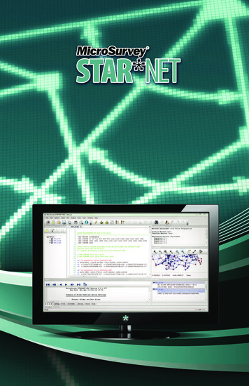
STAR*NET FEATURESOUTPUT RESULTSResults are clear and reliable.yy STAR*NET results are wellformatted for quick review.yy The Sum of Squares, ErrorFactors, and Chi-Squaretest are sensitive to theinputs and give excellentfeedback on what needsto be done to improve yourresults.yy Reports offer tremendousflexibility, so they makesense and only includewhat you want.yy Quick-jump to specificheadings or sections, orselect the tree view of allheadings and sections.yy Blunders and errors arequickly spotted.yy The network plottingvisualization tool showsyou the final correctednetwork, complete witherror ellipsis. You can pan,zoom or locate specificpoints.It gives you confidence in your work.yy Geo-referencing your surveys is much easier. Reports output bothGeodetic and Ground coordinates with combined scale factors.yy STAR*NET produces the ALTA - NSPS results you need for yoursurveys.yy “The Positional Uncertainty of any physical point on a survey,whether the location of that point was established using GPS orconventional surveying methods, may be computed using a minimallyconstrained, correctly weighted least squares adjustment of thepoints on the survey.” – from the ALTA - NSPS Land Title Surveys 2011requirements.6
STAR*NET FEATURESCUSTOMIZABLE INTERFACEDrag-and-dock.yy With your data files list, editorwindow, output summary,network plot and processingsummary, you have a lot ofon-screen information thatneeds to be at hand for crossreferencing, quick fixes andreprocessing. STAR*NET allowsyou to fully customize all panels– easily adjust, move, resizeand bisect window panes toform the best workspace foryour project.Distill the functions down to only those used.yy Completely customizable toolbars.yy Choose between large or small icons.yy Map shortcut keys to any function.yyThe project managerwindow stores yourmost recent or commonly used files.And more!yy Contact us or download the demo to seewhat else STAR*NETcan do for you.7
STAR*NET FEATURESNEW IN VERSION 88yyCS-Map Coordinate System Engine - STAR*NET 8 includes over 3800predefined coordinate systems worldwide, plus a new custom coordinatesystem editor which supports datum transformation and projection types notpreviously supported.yyGeoid Modeling - STAR*NET 8 includes direct support for selecting .bin or .byngeoid models published by national agencies like the United States NationalGeodetic Survey and Natural Resources Canada, without requiring conversionto .ght format using the free STAR*Geoid utility. This includes Canada’s newer.byn format for geoids like HT2.0.yyLeica DBX Conversion Utility (Improved) - The STAR*Leica DBX conversionutility has several improvements, including the ability to convert Resectiondata, and to convert Sets of Angles data using either the average of each set(as before) or using all shots.yyNetwork Plot - All network plot display options are now customizable in anintuitive grid-view. Control the visibility, color, linetype, and size of eachnetwork element to graphically differentiate conventional, GPS, and Levelingobservations. Directional arrowheads indicate both the direction and numberof observations between two stations. Zoom and pan in the network plot viewusing smooth, intuitive mouse controls.yy.PRISM Command - A new “.PRISM” inline option lets you apply a correctionfor measurements that were collected with an incorrect prism offset setting,without having to make potentially thousands of tedious calculations andmanual edits.yyGoogle Maps and Google Earth Support - View your network stations inGoogle Maps by clicking the Map button located in the Find Point dialog, orexport your network stations and connections to a .kml or .kmz file and viewthem in Google Earth. (Compatible with Grid projects only.)yyLevel Loop Tolerance Check - Instantly verify whether or not the verticalmisclosure of your level loops or traverses fall within maximum allowabletolerances, based on its total length and a selected standard of accuracy likeNGS Second Order Class II, NRCan First Order, etc.yyOnline Updater - Stay current with the latest STAR*NET updates andmaximize your return on investment. Check for updates at any time, or use theconfigurable automatic updater to notify you when an update is available.yyData File Monitor - Data Editor now monitors for any changes that are made byan external program to a loaded data file, and will prompt to reload it from disk.Data Editor now immediately updates when a loaded data file is changed byOverwriting or Appending to it with the GPS Importer.yyPlus more, including dozens of improvements.
STAR*NET FEATURESNEW IN VERSION 7yyNetwork Plot Imagery - Enhance your network plot with georeferenced rasterimages and other data files, using local files or online sources.yyIntegrated Data Editor – A fully integrated data editor, which offerscustomizable syntax highlighting (colors/fonts), bookmarking and jumping tobookmarked lines; no more need for an external text editor.yyCustomizable Interface – Brand-new interface which is highly customizableto suit your specific workflow or preferences.yyFind Point – An advanced Find Point tool allows you to quickly locate and jumpto any references to a specific point ID in any of your input data files by simplydouble-clicking a point name in any of your output files.yyLost Stations – A new “.LOSTSTATIONS” inline option is available to identifypoints which are no longer physically available.yyGPS Sideshots – Two new “.GPS NETWORK” and “.GPS SIDESHOT” inlineoptions can be inserted prior to any G1 vector records to define the followingvectors either as part of the network or as sideshot type records that areprocessed after the network has been adjusted.yyPoint Aliasing – A new “.ALIAS” inline option is available which you can use todefine point aliases by explicitly naming the aliases.yyDifferential Levelling Loop Closure Check and GPS Vector Loop Closure CheckyyGPS Antenna Height Corrections – A new “.GPS AddHiHt [HI] [HT]” inlineoption is available to specify or correct GPS base and rover antenna heightblunders.yyProject Manager – A new Project Manager is now available for quickly openingand creating projects.yyTemplate Data File – A new template mechanism allows you to customize atemplate data file that is automatically added to new projects.yy2D GPS Adjustments – 2D Adjustment of GPS Data is now possible.yyNGS OPUS Report Support – An importer for reading station data (adjustedcoordinates with full covariance matrices) from NGS OPUS reports intoSTAR*NET .gps data files is now available in the GPS Importer.yyMicroSurvey FieldGenius Support – A conversion utility for convertingMicroSurvey FieldGenius data collection software .raw files to STAR*NET.yyQuick File References – A new “Quick File References” option in the ListingFile Options screen allows you to display references to the first occurrence ofa file and line number referencing each point.yyAnd more, all added in version 7.9
TESTIMONIALSSEE WHAT STAR*NET USERS HAVE TO SAY“Over the past ten years I’ve found STAR*NET software to be very consistent inhandling raw data files for input to GPS, traversing or leveling adjustments. Theleast squares adjustment algorithms produce reports that are easy to scan andidentify network problems that need to be fixed.I look forward to using STAR*NET for many years to come on transportationcontrol projects.”–James E. Kovas PE, PSWadeTrim“I have been using STAR*NET almost every day for the last 5 years. It isthe perfect tool for combining conventional, GPS and leveling data into acontrol network and checking the validity in a rigorous manner. The datainput and interface elements make it quite simple to perform a LeastSquares adjustment on any type of survey, large or small. It is simply the bestadjustment program that I have used.”–Peter Haas, BCLSFCS Land Services Limited Partnership“STAR*NET adjustments are taught as standard practice at Renton TechnicalCollege. No field control project, whether conducted by total station, GNSS,or both, is considered done unless it is properly weighted and adjusted usingSTAR*NET. This has been our practice since we first got STAR*NET in the early1990s, and it has loaded and run flawlessly on every computer we’ve ever putit on. Students have had the ease of learning the program and running smallnetworks at home using the demo package.”–Martin Paquette, WA, PLS“I was considering writing an adjustment program for OIT Geomatics studentuse when STAR*NET became available in the late 1980s. I was impressed withthe software, it was a full-featured, flexible adjustment program without thelimitations of other adjustment programs. It is easy to use, and the manual isa good adjustment primer in itself. StarPlus donated the software to OIT foracademic use in 1989, and provided updates at no cost, an appreciated level ofindustry support. Generations of OIT Geomatics graduates have learned to useSTAR*NET since that time.”–Jack Walker, PLSDepartment of Geomatics, Oregon Institute of Technology10
TESTIMONIALS“STAR*NET is an essential tool for anyone combining conventional surveymeasurements with GPS measurements. It is extremely simple to use andis completely reliable. Its ability to flag inconsistencies in a survey networkgives me a great deal of confidence.I am pleased to see that STAR*NET will be well supported for many years tocome.”–Ted Eaton, BCLS, CLSEaton Land Surveying Ltd.“I first started using STAR*NET in about 1993, shortly after completingmy Least Squares class at BCIT, where we were taught that least squaresadjustments were simply the best way to resolve traverses and controlnetworks. I’m sure STAR*NET paid for itself on the first major survey we did aswe rarely had any mis-closure issues from that point forward. We immediatelybenefited from being able to process traverse data collected in any order andbeing able to include redundant check shots in the processing.Now I’m in practice for myself, and I wouldn’t process my control any otherway. What other program allows you to geo-reference your survey, computegrid and ground level coordinates, scale factors, convergence, standarddeviations and error ellipses with one click. an
Related Software Data Collection Software 13 Desktop Survey & Design 14 Training and Support 15 Registered in the U.S. Patent and Trademark Office All other brand names, product names or trademarks are property of their respective owners. www.MicroSurvey.com 1-800-668-3312