Transcription
PROCEEDINGS, 46th Workshop on Geothermal Reservoir EngineeringStanford University, Stanford, California, February 15-17, 2021SGP-TR-218Identifying and Assessing Geohazard in Indonesia Geothermal Area: How Difficult Is It?Vicky R. Chandra1, Dorman Purba2,3, Arthur G.P. Nayoan2, Ferdino R. Fadhillah2,4, Rizki Fadhilah Ramadhan2,5, RioAnggara2,61 Geo2 Enerka3 Geonergi4Dipa Energi, Aldevco Octagon, Jakarta, IndonesiaBhumi Pratama, Cibis Nine 11th Floor, Jakarta Selatan 12560, Indonesia,Solusi Indonesia (Geoenergis), Cibis Nine 11th Floor, Jakarta Selatan 12560, IndonesiaGeology, Faculty of Mathematic and Natural Science, University of Indonesia, Depok 16424, Indonesia5Geological Engineering, Pertamina University, Jakarta, Indonesia6Geological Engineering, University of Jambi, Jambi, Indonesiavickyraychandra@gmail.com; dorman.drilling@gmail.comKeywords: geothermal, geology, geohazard, volcano, earthquake, hydrothermal eruption, landslides, IndonesiaABSTRACTIndonesian geology that is formed by a complex of tectonic plate settings, subduction processes and lies along the Pacific Ring of Fireare not only give a vast geothermal energy potential but also high risk of geohazard that could occurs during geothermal exploration anddevelopment activities. Failure in identifying risks of geohazard in early phase of geothermal development plan might cause someproblems and catastrophic events such as damages on bridge, well pad, road access, skewed pipeline, well leaks or broken, impairmentof power plant facilities, and following cessation of electricity production. Moreover, these events also could impact the nature orenvironment surrounding the field and results fatality or loss of human lives. Therefore, it is very critical to have a well - structured andcomprehensive method as a guide to identify and mitigate the geohazard risks.The aim of this study is to gathers and reviews various geohazards in Indonesia geothermal prospect area. Several literatures, author’sprevious studies and records about various possible geohazard cases that have and possibly happen in Indonesia geothermal area arereviewed in this study.1. INTRODUCTION1.1 Geothermal Systems in IndonesiaHochstein and Sudarman (2015) identified the two groups of Indonesian volcanic geothermal systems that defined by using fluidanalyses and volcanic (terrain) settings. The larger group includes geothermal systems that are hosted by young strato-volcanoes andother smaller group includes steeply dipping ‘volcanic feeder (plug-type) systems standing in moderate terrain. These two types ofgeothermal systems asserted that all geothermal fields and prospects in Indonesia are associated with volcanoes and located in the highterrain which is steep and prone to landslides event compare with flat area.Additionally, it is common in Indonesia that in the adjacent of a geothermal field there are some active volcanic centers and thatgeothermal areas are enclosed within seismically active zones (Utami, 2010). Volcanic hazard, earthquake and other hazards indirectlyrelated or even unrelated to geothermal activity may also affect a geothermal field.Geothermal systems itself are dynamic. Their thermal and hydrological structures (and hence the thermal manifestations) to someextent, also affected by the history i.e. natural and artificial changes that has been experienced by the systems. Based on that condition itis understandable that there are plenty of geohazards in geothermal field which could occurs during exploration or development of thefield. Understanding such structures is important when planning construction works on top of a geothermal system because they aredirectly related to the distribution of the hazard-prone sites and the sites that bear technical difficulties for construction.1.2 ObjectivesThe study of geohazard assessment in geothermal field is crucial to finding better management for every geologic hazard thatcontinually threatens some geothermal field in Indonesia from the exploration to the development period. Based on historical data fromseveral developed field, the effects of these hazards have cost EDC in Philippine about USD 6.8 Million annually from 2006 to 2011alone, in the form of disrupted operations, lost revenues and cost of slope stability program (Marasigan & Olivar, 2015).Similar damaged condition that need high restoration cost also happens in Indonesia for example in Wayang Windu field due to massivelandslides event in 2015 occurred around the steam pipeline and settlement area which make it worst due to fatality were recorded from1
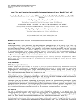
Chandra et al.this event, and also in Salak and Darajat field based on author’s experiences. However, the published information regarding thesesensitive issues was hard to find due to company preferences.The key to effectively addressing the risks inherent to these hazards is timely access to information to aid engineers and management tomake decisions that will minimize, if not fully eliminate, these risks. Eventually the study aims to reduce the vulnerability of thegeothermal facilities, inhabited structures, roadways and local communities to natural disasters that potentially occurs in geothermalfield.2. METHODThis study done by reviewing literatures, news, and professional experiences about geohazard assessment for geothermal field inIndonesia. Based on those, authors try to combine the geohazard occurrence, driving factor and impact. Moreover, several mitigationsand monitoring plans also proposed.3. DATA AND DISCUSSION3.1 LandslideHydrothermal geothermal system associated with volcanic morphology is dominant geothermal system in Indonesia. Those system oftenlocated at stratovolcano with high relief and steep slope. (eg Mt. Salak, Mt. Lawu, Mt. Sinabung, Mt. Slamet, Mt. Merapi, Mt. Pulosariand Mt. Soputan) (Figure 1). This condition makes the flank of stratovolcanoes very prone to collapse and landslides (Francis & Wells,1988). According to Varnes (1978) landslide is a slope movement of slope materials under the influence of Earth's gravity.Figure 1: Left: Steep morphological of Mt. Pulosari (Nayoan et al., 2019). Right: Very steep slope at volcanic dome of Mt.Marapi (Ashari, 2017)The factors that control landslide are the type of sliding, the structure and strength of slope material, and the geometry of the slopewhich has correlation with geological-geomorphological condition (McColl, 2015). According to Karnawati (2005) there are severalfactors that trigger landslides such as the process of rain infiltration, earthquake or vibrations of heavy vehicles / equipment, humanactivities that changes land use and load on slopes. Those all factor increases the critical slopes condition moreover, the presence ofgeothermal manifestation also controls the occurrence of landslide (Utami, 2010).The existence of geothermal manifestations will alter the surrounding area. Example of this case can be found at steaming groundmanifestation which alter and forming swelling clay on topsoil. This material on steep slope is unstable and prone to induce thelandslides (Utami, 2010). Landslides that commonly occur in soil materials are circular based on the landslide classification accordingto Varnes (1978) and proven by the landslides that occurred at Lembata Island in the 1979 that show main scrap feature on the crownside and (Yudhicara et al., 2015) (Figure 2). Lembata landslide were caused by geothermal manifestation proven by landslide materialscontains clay mineral. Hydrothermal alteration creates of clay mineral (smectite and zeolite) on the altered topsoil. This material will beexpansive when exposed to water and induce the landslide.2
Chandra et al.Figure 2: Evidences of the 1979 landslide taken on April 2013, the crown (Left) and the landslide body (Right) (Yudhicara et al.,2013)Manifestations such as hot springs and fumaroles are strongly associated with faults/fractures presences as in Mataloko geothermal field(Nanlohy et al., 2001). Fractured zone can stimulate rockfall-type landslides caused by structural control (Varnes, 1978). While theplanar type landslides tend to rarely occur in geothermal areas because they are more common in strike and dip rocks such assedimentary rock. The landslide events have similarity of geothermal fields with hydrothermal geothermal systems, Stratovolcano withsteep slopes formed from magma with intermediate composition based on the classification according to Wohletz & Heiken (1992).Several landslides related to geothermal working area shown in Table 1. Geological landslide disasters also very sensitive to the localcommunity environment and can cause social problems, therefore mitigation is needed to minimize this impact.Table 1: List of several landslide events in Indonesia's geothermal fieldGeothermal FieldPangalenganSungai PenuhHululaisLocationWayang Windu, West JavaKerinci, JambiLebong, BengkuluGeothermal SystemHydrothermal SystemHydrothermalSystemHydrothermal SystemTime of IncidentMay, 2015January, 2013April, 2016Developer (EBTKE,2017)PT Pertamina GeothermalEnergy KOB Star EnergyWayang WinduPT PertaminaGeothermalEnergyPT PertaminaGeothermal energy.idInitial field identification is required to determine the risk of landslides. Several field indicator that need to be monitor during surveyare: rock cracking in outcrop, the emergence of a water seepage on the slope, bulging and lipping at the foot of the slope, the amount ofmaterial escaping from a slope, and the presence of manifestations on the slopes that can flow and form mineral clay on the slopematerial (Figure 3).Mitigation related to landslide hazards can be done by providing non-structural mitigation such as providing information, disseminatinglandslide disasters, training and simulating landslide disasters which can provide insight for the local community (Rahman, 2015).Desktop studies and regional mapping are important things to do to determine the condition of the geothermal area, the GIS method isalso important to use to determine landslide-prone areas in geothermal fields by making a slope and FFD map overlaid with a surfacemanifestation to determine the orientation of the structural control. on a geothermal field (Figure 4).3
Chandra et al.Figure 3: Structural indication of rock-fall landslide on outcrop scale (Left) and Fumarole manifestation with landslide material(Right)Figure 4: Example of FFD Map overlaid with Geothermal Manifestation (Left) (Nayoan et al., 2020) and Example of Slope Mapto Predict Landslide in Menoreh Mountains (Hadmoko et al., 2010)3.2 High Temperature and Gas ZoneThe existence of geothermal manifestations indicates that the geothermal area system is active. This area associates with hightemperature and gaseous zone that must be identify and monitor to prevent further hazard. According to Utami (2010) (Table 2) in ahydrothermal geothermal system with a high relief order, the existence of geothermal manifestations has potential for disasters such asthe presence of thermal & altered ground, fumaroles & gas vents, and acid hot springs.Early identification of manifestations location associated with high temperature zones can be execute using remote sensing analysisbased on satellite imagery and gravity data. This method has conducted on northern Sulawesi area with result accuracy up to 87.5%(Julzarika and Nugroho, 2019). Moreover, the manifestation risk must be identified by field survey as basis of high temperaturemitigation plan. The mitigation that needs to be done is the socialization of the community and the company, giving a warning sign onseveral manifestations that can injure or threaten human life (e.g. fumaroles & gas vent which may contain H2S and CO2 or acid supply4
Chandra et al.hot spring). An example cases from this geohazard like in the not-yet produced Dieng geothermal system a high CO2 gas concentrationis uncommon in Indonesian fields, but during the eruption of the Kawah Sinila in 1979 which claimed 182 lives (Harian Sinar Harapan23 Februari 1979 in Wintolo, 1979).Table 2: Gas & High Temperature Zone Description and Potential Hazard Table3.3 Flash FloodFlash floods is sudden water movements in short duration with massive volumes carrying debris materials such as soil, trees and rocksat high velocities associated with heavy rain, cyclones, and storms (WMO, 2012; PUPR, 2012; Otieno, 2018).This disaster start by significance in-charge to the stream by high intensity rainfall at the upstream area creates the water volume abovestream capacity. Natural dam formation from landslide or illegal logging activity could block the stream flow and trigger the energyaccumulation. At some point this natural dam will release the destructive water flow simultaneously with high velocity up to 160 km/hand destroy any buildings along stream flow (WMO, 2012; PUPR, 2012; BNPB, 2016). Based on National Disaster ManagementAuthority/BNPB (2016), the area with steep slope and high intensity rainfall that has stream is the characteristic of flash flood pronearea.Figure 5 Illustration of flash flood related to geothermal area5
Chandra et al.The characteristic of flash flood prone area also has similarity with Indonesia geothermal area which on high relief terrain and tropicalclimates. Flash flood disaster will be very dangerous at geothermal working area due to the facility and drilling activity. This incidenthas occurred in Lebong Geothermal Area with causalities, injuries, missing victims from employees, contractor, and locals (Progres.ID,2016; Bengkulu Government, 2018; KOMPAS, 2018)Several mitigations could be executed, such as:-Risk identification and assessmentFlash flood risk map creates by integration of natural disaster history, hydrology, and remote sensing analysis to identify flowheight and velocity at the prone area (Psomiadis, Soulis, Zoka, & Dercas, 2019). Landslide risk map also can add as input datasince that hazard also contributes for flash flood generation. The coverage area of this map is relative wide, so the utilizations ofremote sensing with 30 meters to 0.5-meter resolution is effective for geomorphological and land utilization at upstream area(Psomiadis, Soulis, Zoka, & Dercas, 2019). Most of input data is open access data that available on related government institution.Furthermore, this map can be used as parameter of working area development and disaster task force preparation since theprediction of flash flood has high level uncertainties due to complexity and varieties of driving factor (Montz & Gruntfest, 2002)-Warning systemEarly warning by live monitoring of natural and early sign of flash flood along stream flow is the simplest way for flash flood.The monitoring can be done by operators, CCTV or locals report to the certain task force of geothermal developer. Based on thosereports, the risk assessment will be performed to determine evacuation (PUPR, 2012). The key parameters for this method are:-Forming natural dam on upstreamHigh intensity rainfall within long durationHeavy cloud on upstreamRapid change on stream level-Environmental damage activity on upstreamIncreasing of sediment on streamRoar from upstreamFigure 6 shows the warning stage from monitoring to execution of evacuation.Figure 6: Warning stage of flash flood (modified from PUPR,2012)-Effective communicationEffective risk communication is crucial part to raise knowledge and awareness from all stakeholders and locals to reduce the riskof hazard. Pitfalls from this aspect will show significance impact (Kellens, Terpstra, & Maeyer, 2013). By effectivecommunication between geothermal developer, government, and locals the prevention of flash flood hazard can be optimizedfrom hearing activity about local activity on upstream, education about flash flood hazard and simulation of evacuation plans. Thecommunication also prevents miss-perception between locals and developer about occurrence of natural disaster.3.4 EruptionConsidering Indonesia is inhabited by 128 volcanoes (Table 3) with 4 volcanic arcs (Sunda Arc, Banda Arc, Halmahera Arc, and NorthSulawesi-Talaud Arc) the danger of eruptions in Indonesia has become a general matter that must monitored. According to Zaennudin(2010) about 13 % of the world’s active volcanoes are located in Indonesia. If we look a little to the past regarding geothermalexploration in Indonesia, over 20 volcanic geothermal systems were explored in Indonesia between 1970 and 2000 (Hochstein andSudarman, 2008) and most prospects are associated with volcanoes of high relief (mainly strato-volcanoes) (Hochstein and Sudarman,2015).This indicates that almost all geothermal fields (WKP) in Indonesia are located in volcanic areas and geohazard constraints must be veryvigilant because they can impact social-economic problem in geothermal industry itself and local community in the surrounding area.Examples case of volcanic eruptions in geothermal areas are located in Mt. Tangkuban Parahu on West Java with PT. PLN (Persero) asthe developer (ESDM, 2017). Based on the press released by MAGMA Indonesia (https://magma.esdm.go.id/) that Mt. TangkubanParahu erupted (Figure 7) on 2 August 2019. From geological agency profile report about Mt. Tangkuban Parahu(https://vsi.esdm.go.id/) the latest volcanic activity occurred in 2004 with an increase in seismicity in the volcanic area while the latesteruption occurred in 1994 with an increase in strong activity with shallow seismic earthquakes with small phreatic eruptions.6
Chandra et al.Therefore, what we need to be done to minimize the problem of eruption geohazards is coordination between geothermal field developerwith the local government volcanology agency (PVMBG or ESDM) in monitoring volcanic activity. Mitigation like socialization to thelocal community regarding the geohazard disaster of volcanic eruptions can at least provide insight into the worst possible scenario tothe community. Training or safety induction about eruption needs to be done to the local community, even workers in the geothermalfield. For example as suggested by Hermon et al (2019) in the case of the Mt. Sinabung in North Sumatra that Karo Regencygovernment have to include disaster education curriculum starting from the elementary to secondary schools, conducting socialization indisaster-prone zones, and conducting disaster-based spatial planning to reduce the risks that will occur in the future.Table 3: Distribution of Indonesian Active Volcanoes (Zaennudin, 2010)Figure 7: Photo of Mt. Tangkuban Parahu eruption in 2 August 2019 (https://magma.esdm.go.id/)Remote sensing analysis combine with geomorphology analysis is very good for use in volcanic eruption mitigation. Joyontono et al(2019) using LaharZ software modelling primary lahar in Ijen Volcanic Complex, to know where the potential place or area that damageor causality in Ijen Caldera Complex near Pahit River by calculate the volume that being fill pixel value in river valley considered aslahar mass trough channel (Figure 8). LaharZ give a result when it’s used to zoning lahar hazard zone in Sempol Sub-district,7
Chandra et al.Bondowoso. The Primary Lahar Hazard Maps give very good guidance to the volcanic hazard management, especially to reducecasualties by primary lahar and even secondary lahar. Ijen Volcanic Complex is also one of the Geothermal Field (WKP) in Indonesiathat developed by PT. Medco Cahaya Geothermal (ESDM, 2017).Figure 8: Example of lahar hazard zoning processing in Sempol Area District, Bondowoso. (A.) DEM Hillshade Model ofSempol Sub-district, (B.) River Identified by running LaharZ, (C.) Volume 1% of Ijen Crater Lake is performed to fill channel,(D.) Re-delineate scope area of LaharZ modelling result (Joyontono et al, 2019)4. RECOMMENDATIONMost of geohazard has natural sign that can help geothermal developer to identify the risk and impact. Since the impact of geohazardrelated geothermal site and development often reach catastrophic level, the awareness and understanding about this challenge needsimprovement includes the understanding of hazard record. Figure 9 shows the frequencies of published geohazard occurrence related togeothermal site in last ten years, this data needs elaboration for better understanding of geohazard condition in geothermal area.Figure 9: Geohazard frequencies related to Indonesia geothermal site in last 10 years8
Chandra et al.The geothermal hazard will have big impact related to geothermal exploration and development activity not only for technical aspect butalso the social impact around geothermal area. It is important to prevent geohazard by geothermal developer. Several action thatrecommends executing are summarize in Table 4.Table 4: Mitigation action of geohazard (modified from PUPR,2012)ActionDescriptionRisk assessmentGeothermal developer determines and predict hazard riskrelated to stakeholder, project and developmentMonitoring and earlywarningHSE team with locals monitor the prone area related to theactivity that increase the risk and early natural sign of hazardCommunicationEstablish the effective communication related to informationexchange, early warning, and evacuation coordinationbetween all stakeholder under certain task forceActivity-Hazard identificationVulnerability analysisRisk predictionEarly warning systemTask force team preparationEvacuation planProvide communicationtools and procedure4. CONCLUSIONIt is clear that although Indonesia has an abundant geothermal potential, it is also accompanied by high geohazard risks due to itsgeological setting. Natural geological hazards such as landslides, high-temperature and gas zones, flash flood, and eruptions(hydrothermal, phreatic and volcanic) may occur and harm the developed geothermal field or even the unexploited geothermal prospectareas. A detailed and well-structured geological mapping, which consists of geological structures, eruption centers, volcano stratigraphyand thermal manifestations, is the best method to reduce the risk from natural geological hazard. Moreover, reviewing map of volcanichazard and volcanic activity and earthquake history data from Volcanology Board Indonesia will also help to minimize the risk.At the development stage, geothermal fields might suffer more geohazards such as landslides, subsidence, rock falls and all other naturalgeohazards. Integration between geological, slope stability and GIS map with rainfall data might be the best tool to reduce the landsliderisk within the fields. Furthermore, tiltmeter and inclinometer should be installed to monitor the landslide prone area. Drone is one ofthe most recent technologies that can help to survey the remote area where it is inaccessible.Geohazard assessment is an essential step in exploration stage, so the risk that might be occurred caused by geohazard can beminimized. Therefore, geohazard study needs to become a mandatory evaluation at the exploration stage, before the geothermalprospect area is exploited further. Government may conduct a strict regulation regarding this geohazard assessment in order to attractthe investor to develop geothermal prospect area and reducing the loss, e.g. financial, human lives, and nature environment.Finally, this preliminary study has reviewed several geohazards that has occurred in the past and has the potential to reappear in thefuture, in various geothermal areas in Indonesia. Several points that can become a potential path forward for this study are:1.Conduct interviews with or surveys to various geothermal developers in Indonesia regarding the geohazard identificationmethods and mitigation action plan that the developers have applied in their geothermal field.2.Develop a geohazard identification and mitigation procedure that can serve as a general guidance for geothermal explorationprojects in Indonesia.REFERENCESAshari, A. (2017). Geomorphology of the Southern Flank of Merapi Volcano in Relation to the Potential Hazards and NaturalResources: A Review. Geomedia: Majalah Ilmiah dan Informasi Kegeografian Volume 15 Nomor 2.Bengkulu Goverment. (2018, 03 28). DPD RI Gelar Rapat Terkait Dampak Lingkungan PGE Lebong. Retrieved from PemerintahProvinsi Bengkulu: it-dampak-lingkungan-pembangunan-pge-lebong/BNPB. (2016). Resiko Bencana Indonesia. Jakarta: Badan Nasional Penanggulangan BencanaESDM. (2015). Buku Panduan Penyelidikan Panas Bumi. Pusat Sumber Daya Geologi, Badan Geologi ESDM. ISBN: 978-602-910564-3ESDM. (2017). Potensi Panas Bumi Indonesia Jilid 1. Jakarta: Direktorat Jenderal Energi Baru, Terbarukan Dan Konservasi Energi.Francis, P.W., Wells, G.L. (1988). Landsat Thematic Mapper observations of debris avalanche deposits in the Central Andes. Bulletinof Volcanology 50, 258–278. https://doi.org/10.1007/BF01047488Hadmoko, D.S., Lavigne, F., Sartohadi, J., Pramono, H., & Winaryo. (2010). Landslide hazard and risk assessment and theirapplication in risk management and landuse planning in eastern flank of Menoreh Mountains, Yogyakarta Province, Indonesia.Nat Hazards 54, Page 623–642. https://doi.org/10.1007/s11069-009-9490-09
Chandra et al.Hermon, D., Ganefri, Erianjoni, Dewata, I., Iskarni, P., and Syam, A. (2019). A Policy Model of Adaptation Mitigation and Social Riskthe Volcano Eruption Disaster of Sinabung in Karo Regency-Indonesia. International Journal of GEOMATE, Aug. 2019, Vol.17,Issue 60, pp.190-196. ISSN: 2186-2982.Hochstein, M.P., Sudarman, S. (2008). History of geothermal exploration in Indonesia from 1970 to 2000. Geothermics, 37, 220-266.Hochstein, M.P., Sudarman, S. (2015). Indonesian Volcanic Geothermal Systems. Proceedings World Geothermal Congress 2015.Joyontono, P., Harijoko, A., and Wibowo, H.E. (2019). Geomorphological Analysis to Determine Hazard Map Related to PrimaryLahar of Ijen Crater Lake, Ijen Volcanic Complex, Indonesia. PROCEEDINGS JOINT CONVENTION YOGYAKARTA 2019,HAGI – IAGI – IAFMI- IATMI (JCY 2019). ISBN-978-979-8126-37-6.Karnawati, D. (2005). Bencana Alam Gerakan Massa Tanah di Indonesia dan Upaya Penanggulangannya. Jurusan Teknik Geologi,Universitas Gadjah Mada, Indonesia. ISBN 979-95811-3-3.Kellens, W., Terpstra, T., & Maeyer, P. D. (2013). Perception and Communication of Flood Risk: A Systematic Review of EmpiricalApproach. Gent.KOMPAS. (2018, 03 09). Dituding Penyebab Banjir, Anak Perusahaan Pertamina Digugat dan Dilaporkan ke Presiden. Retrievedfrom Kompas Media Digital Group: na-digugat-dan-dilaporkan-ke?page allMarasigan , R., & Olivar, R.: Distributing Access to Geohazard Information Using Web GIS for EDC Geothermal Field Sites.Proceedings World Geothermal Congress 2015. Melbourne (2015).McColl, S. T. (2015). Chapter 2 - Landslide Causes and Triggers. Landslide Hazards, Risks and Disasters, Academic Press Pages 1742. ISBN 9780123964526Montz, B. E., & Gruntfest, E. (2002). Flash flood mitigation : recommendation for research and application. Environmental Hazard, 15- 22.Nanlohy, F., D. Kusnadi, dan B. Sulaeman. (2001). Geology and Geochemistry of Mataloko Geothermal Field Central Flores-EastNusa Tenggara. PROCEEDING OF THE 5th INAGA ANNUAL SCIENTIFIC CONFERENCE & EXHIBITIONS. Yogyakarta.Nayoan, A.G.P., Naslan, M.R., Pauling, L., & Deny. (2019). Potensi Geowisata Desa Sukasari, Kabupaten Pandeglang, ProvinsiBanten. Seminar Nasional Ilmu Kebumian-Geodiversity 2019.Nayoan, A.G.P., Sammuel, E.R., Widiastrawan, I.M.D., Pudyastuti, K., & Hendrasto, F. (2020). Recommendation in Geothermal WellTargeting in the “DEA” Field Based on Isothermal Model and Geological Indication. Proceeding Digital Indonesia InternationalGeothermal Convention (DIIGC) 2020. ISBN 978-602-52132-3-6Otieno, V. (2018). Geohazards in Geothermal Resource Exploitation. SDG Short Course III. Kenya: United Nation University.Progres.ID. (2016, 04 28). Ini korban bencana banjir bandang di fromprogres.id:Psomiadis, E., Soulis, K. X., Zoka, M., & Dercas, N. (2019). Synergistic Approach of Remote Sensing and GIS Techniques for FlashFlood Monitoring and Damage. MDPI.PUPR. (2012). Pedoman Manajemen Penanggulangan Bencana Banjir Bandang. Jakarta: Kementrian Pembangunan Umum RepublikIndonesia.Rahman, A.Z., (2015). Kajian Mitigasi Bencana Tanah Longsor di Kabupaten Banjarnegara. GEMA PUBLICA Jurnal Manajemen danKebijakan Publik Vol. 1, No. 1. ISSN 2460-9714.Rolfe, K.A. (1980). Air pollutants associated with geothermal energy. The New Zealand Energy Joumal. 25 May 1980.Sumotarto, U. (2015). Eksplorasi Panas Bumi. Penerbit Ombak. Yogyakarta.Utami, Pri. (2010). High-temperature Geothermal Area and its Challenges for Civil Engineering Works. PERTEMUAN ILMIAHTAHUNAN XIV HATTI. Indonesia.Varnes, D.J. (1978). Slope Movement types and Processes. Special Report Page 68 - 76. Washington D.C.WMO. (2012). Integrated Flood Management Tools Series : Management of Flash Floods. World Meteorogical OrganizationWohletz, Kenneth, and Grant Heiken. (1992). Volcanology and Geothermal Energy. 1/University of California Press.Yudhicara, Hidayati, S., and Suparan R. (2013). Laporan Penyelidikan Tsunamigenik di Pulau Lembata, Nusa Tenggara Timur. Internalreport of Center for Volcanology and Geological Hazard Mitigation, Geological Agency.Yudhicara, Bani, P., & Darmawan, A. (2015). Geothermal System as the Cause of the 1979 Landslide Tsunami in Lembata Island,Indonesia. Indonesian Journal on Geoscience Vol. 2 No. 2, Pages 91 – 99.10
Chandra et al.Zaennudin, A. (2010). The characteristic of eruption of Indonesian active volcanoes in the last four decades. Jurnal Lingkungan danBencana Geologi, Vol. 1, No. 2, 113 – 129.“Longsor di Pangalengan, 14 Orang Masih Tertimbun”, 2015, onal/20150505224600-20-51444/longsor-di-pangale
1 Geo Dipa Energi, Aldevco Octagon, Jakarta, Indonesia 2 Enerka Bhumi Pratama, Cibis Nine 11th Floor, Jakarta Selatan 12560, Indonesia, 3 Geonergi Solusi Indonesia (Geoenergis), Cibis Nine 11th Floor, Jakarta Selatan 12560, Indonesia 4 Geology, Faculty of Mathematic and Natural Science, University of Indonesia, Depok 16424, Indonesia