Transcription
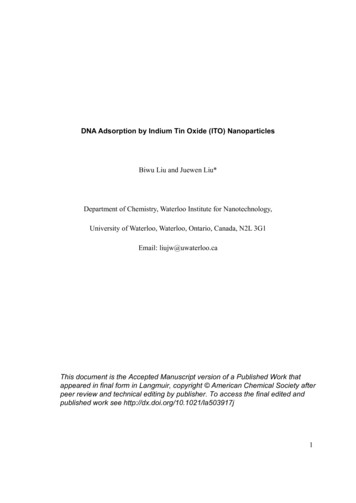
AUTO TOURAAA Washington Travel ServicesOlympic PeninsulaThe Olympic Peninsula is one of North America’s scenic marvels. Saltwater shores form its western,northern and eastern flanks. A dense forest covers much of the peninsula, occasionally cleared forfarming as in the Chehalis Valley in the south and the Dungeness Valley in the northeast. Over acentury of logging has left its mark on the landscape in the extensive areas of clear cuts, secondgrowth forest and vast reforestation tracts, found principally around the margins of the peninsula.(Left) Trails lead from Hurricane Ridge through conifer groves & alpine meadows. Views stretch across deep valleys to therugged wilderness of the park’s interior; (Right) Iconic moss-covered maples at Hoh Rain Forest in Olympic National ParkThe rugged Olympic Mountains, a realm of deep valleys and glaciated crags, dominate the central part of thepeninsula. Their western slopes face the prevailing westerly winds and the resulting copious rainfall (upwards of200 inches per year) nurtures the western hemisphere’s largest temperate rain forest. On the opposite side of thepeninsula, rainfall in the Dungeness Valley is so light (averaging less than 20 inches), that farmers must irrigatetheir crops.President Theodore Roosevelt proclaimed the core of the peninsula Mt. Olympus National Monument in 1909.In 1938 Congress enlarged its area and established OLYMPIC NATIONAL PARK. Today the park covers 1,431square miles, including a 60-mile strip along the Pacific. In recognition of its exceptional natural features anddiversity, the United Nations designated the park a World Heritage Site in 1982.Our self-guiding auto tour encircles the Olympic Peninsula in a clockwise direction. Most of the route, part ofthe Pacific Coast Scenic Byway, is an excellent two-lane highway – with some multi-lane sections from Olympiato Shelton and Hoquiam, and between Port Angeles and Sequim. The route is driveable year round, although thebest weather occurs in the summer and early fall. Rain, heavy at times especially in the west, constitutes theprimary driving hazard. Although precipitation occurs in all months, it is heaviest from November through April.Snow is relatively infrequent at lower elevations, but remains on the ground from winter into early spring atelevations above about 3,000 feet.-1-
1. Olympia to Grays Harbor(via US-101, WA-8 and US-12)Our Auto Tour starts at OLYMPIA (pop. 52,5000, alt. 130 ft.), Washington’s seat of government since the territorywas created in 1853. The city enjoys a dramatic setting on the wooded shores of Budd Inlet, the southernmost reachof Puget Sound. To the east rises the snowy dome of Mt. Rainier. The craggy profile of the Olympic Mountainsmarks the northwestern horizon. For more on Washington’s capital city see the club’s companion publicationDESTINATION FOCUS: OLYMPIA.From I-5 Exit 104 at the south end of Olympia head west on US-101. This is the beginning of the Pacific CoastHighway, which circles the peninsula then heads south along the west coast, ending in Los Angeles. Just west ofthe city we cross Mud Bay, an inlet of Puget Sound. Low tides expose a fringe of mud flats, which inspire its name.Oyster harvesting along these inlets dates back to the Native American period. Six miles west, US-101 swings north,to Shelton and Hood Canal – this will be our itinerary on the return leg. Continue west on SR-8, which climbs overthe Black Hills, cloaked in second-growth forest.-2-
Twenty miles west of Olympia, and a mile north of the highway, stands McCLEARY (pop. 1,760, alt. 257 ft.), alumber town with rows of company-built frame houses and the historic McCleary Hotel built in 1912. The town isnamed for Henry McCleary, who established a sawmill in 1898. The door factory here was at one time the largestin the world. The McCleary Museum, 314 Second Street, has displays on logging and early town history (openweekend afternoons, June-August).Highway 8 continues west, entering the Chehalis River Valley, a lush landscape of dairy farms. At ELMA(pop. 3,360, alt. 50 ft.) we join US-12. Named for Elma Austin, a pioneer settler, the town first prospered as alogging center; today it trades with valley farmers. Elma hosts the Grays Harbor County Fair each August. Thehuge concrete structures on the south side of the valley are the cooling towers of the never-completed Satsopnuclear power plant.MONTESANO (pop. 4,155, alt. 66 ft.), seat of Grays Harbor County, is the birthplace of commercial forestry’stree farm system – the Clemons Tree Farm, established in 1941, extends over vast areas north and south oftown. Settlement here started in the early 1850s. Pleasant residential neighborhoods extend north and west ofthe downtown area, guarded on the north by the impressive 1912 Grays Harbor County Courthouse – stepinside for a look at the historical murals. The Vidette, a local weekly, has been publishing continuously since1883, making it Washington’s oldest newspaper still in business. In May rhododendrons add brilliant splashes ofcolor throughout the town. A former church at 703 W. Pioneer Ave. now houses the Chehalis Valley HistoricalMuseum. LAKE SYLVIA STATE PARK (Discover pass required, see below), a mile north of town on the site of thearea’s first sawmill, features a 2-mile forest management interpretive trail.Note: As of July 2011, a Washington Discover Pass is required foradmission to day-use areas of state parks, as well as areas administeredby the state Department of Fish & Wildlife and the Department of NaturalResources.The fee is 10/car for a one-day pass, or 30 for an annual pass.Purchase the pass from any State Parks regional office or at the park itselfwhen staff is available. Click www.discoverpass.wa.gov for details on othermethods of purchase, including over 600 locations where hunting andfishing licenses are sold (transaction fees apply). A 99 fine can be leviedagainst drivers of street-legal vehicles caught without a Pass.Overnight campers in state parks need not purchase the Discover Pass forthe nights they’re camping.Multi-lane US-12 continues west through lush pasturelands to the Aberdeen-Hoquiam area, the largestpopulation center on the Washington coast. Historically these were major lumber processing and shipping ports,although the timber-based economy is in decline – the sprawling waterfront mills and sorting and storage yardsare considerably less active these days.ABERDEEN (pop. 16,760, alt. 25 ft.) spreads across the flats on the north side of the bay at the point wherethe Wishkah and Chehalis rivers empty into Grays Harbor. Although the first settlers arrived in the late 1860s, thetown wasn’t platted until 1883. First called Wishkah (from woos-kla, a Native American phrase loosely meaning‘stinking water’), it was changed in 1884 to honor the Aberdeen Packing Company in Ilwaco, which was in turnnamed for Aberdeen, Scotland.From the start, the region’s great timber wealth was the city’s economic mainstay. In the early 1900s,Aberdeen became one of the West’s great timber ports and milling centers. Following a disastrous fire in 1903,the central business district was rebuilt with substantial brick structures, many of which remain. By 1910, dozensof lumber and shingle mills lined the waterfront and Aberdeen’s population rose to 17,000. The bars and bawdyhouses of the waterfront district gave Aberdeen a reputation as a wide-open town. The Great Depression of the1930s slowed the city’s growth, but employment surged during World War II – Aberdeen’s population peaked at24,000 in the 1940s. Changing economies have left the city with a careworn visage, especially in the boarded upstorefronts and abandoned lots in its central core.Rail fans might enjoy the disused Northern Pacific Depot (on River Street between ‘K’ and ‘L’ streets.Passenger train service ended here in the 1950s. For a peek into the halcyon days, stop by the AberdeenMuseum of History chronicles the lifestyles in the late 19th and early 20th centuries in the area. Note: themuseum is looking for a new home after a major fire in spring 2018.Wooded hills frame Aberdeen’s northern flank where pleasant neighborhoods such as Bel Aire commandsweeping views of the city and harbor. Here the city’s entrepreneurs and elite built substantial homes designed-3-
by eastern architects in the Colonial Revival, Tudor Revival, Mission Revival and Prairie styles. Giantrhododendrons add brilliant splashes of color at their peak in May. At Samuel Benn Park, at E. 9th and ‘I’streets, paths lead through landscaped, rolling hills to a formal rose garden. This was part of pioneer SamuelBenn’s estate, acquired by the city in 1929.Grays Harbor Historical Seaport is developing a maritimeattraction on the South Aberdeen waterfront known as TheLanding. When they in port here you can tour the tall shipsHawaiian Chieftain and the Lady Washington, the latter a fullscale replica of Captain Robert Gray’s 18th-century sailing brig.The Lady Washington starred as the HMS Interceptor in the firstPirates of the Caribbean movie.Aberdeen holds a special place in the hearts of Generation-Xmusic fans as the birthplace of Kurt Cobain, lead singer andsongwriter for 1990s grunge juggernaut Nirvana. Cobain spenthis childhood here and met band co-founder bassist KristA Chinook tribal canoe approaches tall shipNovoselic in the mid-80s. The two joined forces with drummerHawaiian Chieftain on Grays Harbor; LadyDave Grohl to launch the Seattle sound into the mainstream inWashington in background. [Photo: Daily World]the early 90s, but Nirvana’s meteoric rise ended after Cobain’sdeath in 1994. In Aberdeen, Cobain is memorialized on the city’s welcome sign, which invites visitors to Come AsYou Are. A large guitar sculpture marks Kurt Cobain Park, near the Youngs Street Bridge, where the youngmusician used to hang out.HOQUIAM (pop. 8,560, alt. 20 ft.) borders Aberdeen on the west, straddling its namesake river. Hoquiam is anAmerican Indian word meaning hungry for wood, appropriate in view of its role as a forest products processor andexporter. The first European settlers arrived in the 1850s, grazing cattle in lush pastures beside the tide flats. Bythe late 1860s the settlement boasted a post office; the first school opened in 1873. California lumberman AsaSimpson opened a sawmill at the mouth of the Hoquiam River in 1882. After the arrival of railroads in the late1880s and early 1890s, the lumber boom brought prosperity to the new city. Originally four miles apart, Hoquiamand Aberdeen have grown together – the boundary runs down the middle of Myrtle Street.Downtown Hoquiam’s compact business district hugs the west bank of the Hoquiam River. As in Aberdeen, alarge number of shops and buildings are boarded up. Built in 1927-28, the Seventh Street Theatre (313 7thStreet) was the first in the state to show talking motion pictures – today it hosts concerts and plays. At the foot of8th and 9th streets a walkway leads along the Hoquiam River. A Port Viewing Tower, at the foot of 28th Street(south of US-101 in the eastern part of Hoquiam), overlooks the industrial harbor. Here you can watch logs beingsorted and loaded onto cargo vessels. Most of the cargo is bound for the Far East. On the opposite bank alongRiverside Avenue is the Grays Harbor Farmer’s Market & Craft Fair, open year-round.Several historic homes, former abodes of the city’s timber barons, are worth a stop. Hoquiam’s Castle, 515Chenault Ave., is a 20-room turreted Victorian gem, built in 1897 as the home of Robert Lytle. It is now a privateresidence. The hilly neighborhood north of here features other substantial residences set amid lush landscaping.Polson Museum, on the east bank of the Hoquiam Riverat 1611 Riverside Ave. (US-101), was the home of lumberheir F. Arnold Polson. The 6500 square-foot, 26-roomCraftsman-style mansion was built in 1924. Note thefloorboards made of Western hemlock – they run knot-free,from wall to wall and are indicative of the high quality timberof the region’s original virgin forest. The home’s interiorcontains historical displays of the Grays Harbor area. Thesurrounding park contains a rose garden (the site of theoriginal mansion) and many exotic trees. The museum isdeveloping a Railroad Camp to house its large collection ofheavy machinery from the logging industry, including aBaldwin locomotive. Hoquiam’s Polson Museum showcases both thecraftsmanship of the 1920s and the history of the area.West of Hoquiam, the Grays Harbor National WildlifeRefuge protects an expanse of tide flats and marsh grass,prime habitat for migratory birds that feed here in great-4-
flocks during spring and fall. Peak birding occurs in April and early May, when hundreds of thousands of birdscongregate to feed. Prime viewing is from two hours before to two hours after high tide. To reach the refugefollow signs to the airport from SR-109, 1½ miles west of Hoquiam. Drive to the end of the road, walk along thegated hangar access road to the 1,800-foot boardwalk, which leads out into the refuge. The site is open daylighthours daily.2. Hoquiam to Sappho(via US-101 & Olympic NP)From Hoquiam US-101 strikes north, crossing a wooded lowland coursed by dozens of streams. Fishhatcheries near HUMPTULIPS (pop. 255, alt. 131 ft.) and NEILTON (pop. 315, alt. 483 ft.), tiny communitiesalmost lost in the woods, are open to the public. North of Humptulips (its name means ‘chilly region’) a ForestService Road runs 24 miles east to the site of GRISDALE (alt. 805 ft.), once a bustling lumber camp. Thefoothills north of here receive some of the highest rainfall in the 48 states. Wynoochee Lake, just north ofGrisdale, records upwards of 150 inches per annum.Highway 101 reaches Lake Quinault (alt. 186 ft.), bracketed between two forested ridges at the southwestcorner of OLYMPIC NATIONAL PARK. The lake’s north shore is part of the park while the south shore is underForest Service administration. The lake itself is under tribal jurisdiction. The South Shore Road leads along thelake, passing several campgrounds and the scattered community of QUINAULT (pop. 160, alt. 221 ft.). LakeQuinault Lodge, built in 1926 and designed by Seattle architect Robert reamer (who also designed YellowstonePark’s Old Faithful Inn), is on the National Register of Historic Places. Its Roosevelt Dining Room recallsPresident Franklin Roosevelt’s 1937 visit to thelodge. Nearby, the small Lake QuinaultMuseum, located in the former post office, hashistorical displays.Near Willaby Campground nature trails leadthrough groves of ancient trees in an area knownas the Valley of the Rain Forest Giants.Farther east, a short trail leads to the world’stallest Sitka spruce, a 191-foot specimen morethan a thousand years old. The gravel roadcontinues 17 miles along the Quinault River toGraves Creek in the southern part of the park.From road’s end a trail continues into thewilderness heart of the park.The North Shore Road runs through ParkService land along the lake six miles to theQuinault Rain Forest Ranger Station (openThurs.-Mon. June-September). The road continues (becoming gravel)another nine miles, where a side roadcrosses the Quinault River to connect with the South Shore Road forming a pleasant loop drive. A gravel roadcontinues a further three miles along the North Fork Quinault River to North Fork Campground where anothertrail follows the river deep into the wilderness high country.Lake Quinault Lodge nestles among conifers at the edge of itsnamesake lakeAt Lake Quinault, US-101 strikes west, traversing the northern part of the Quinault Indian Reservation.Eleven miles west of the lake, Forest Road 21 winds a further 11 miles north to the strip of national park land thatextends along the Queets River. Watch for logging trucks workdays on this road. The glacial-carved upperreach of the valley is one of the park’s least visited areas, a temperate rain forest of towering Sitka spruce andmoss-draped Bigleaf maple. The more direct Lower Queets Valley Road was severed by a 2005 landslide.After crossing the Queets River US-101 reaches the ocean at the village of QUEETS (pop. 175, alt. 35 ft.). Thehighway runs north along the beach for a dozen miles. This is the only point in Washington where Highway 101fronts the Pacific. This coastal strip, stretching north to beyond Cape Alava was added to Olympic National Parkin 1953. At the village of KALALOCH (pop. 75, alt. 42 ft.) there is a lodge set on a bluff overlooking the ocean.Kalaloch Lodge is the only oceanfront national park hotel in the United States. A roadside pullout offers views ofDestruction Island several miles off shore. Spanish explorers named it Isla de los Dolores (Island of Sorrows),recalling the death of several of the crew. Sea lions and seals crowd its rocky shore. Ruby Beach, a mile north,takes its name from tiny crystals of red garnet, which give the sands a pinkish hue. It’s an easy stroll along the-5-
wide beach to the mouth of the Hoh River. Take care when crossing the driftwood piles that line the upper part ofthe beach. The highway turns inland following the Hoh River.Turn east on the Upper Hoh Road. After 18miles it ends at the HOH RAIN FORESTVISITOR CENTER six miles inside the boundaryof Olympic National Park. This must-see area isone of the iconic habitats of the park, one of thefinest remaining examples of temperate rainforest in the United States.Here and in other west-facing valleys of theOlympics, moist Pacific air systems dumpupwards of 200 inches of rain a year. The mild,damp climate nourishes lush vegetation. Thetallest trees, some exceeding 200 feet, are Sitkaspruce and Western hemlock. Beneath thiscanopy grow Bigleaf maple. The forest floor is atangle of vine maple and sword fern – mosscarpets the ground, coats tree trunks and drapesfrom branches. The scattered clearings areSee every shade of green in the Hoh Rain Forestcreated by the browsing habits of the indigenousRoosevelt elk.Trails in the Hoh area include the Hall of Mosses (0.8-mile), the Spruce Spruce Nature Trail (1.2-mile) and ashort, paved Mini-Trail (ADA accessible). For the very energetic, the Hoh River Trail leads 18 miles to BlueGlacier.Highway 101 continues north. BOGACHIEL STATE PARK (Discover pass required, see p. 3) offers hiking trails,fishing and camping beside its namesake stream.Just up the road is the bustling logging town of FORKS (pop. 3,615, alt. 303 ft.). Lumbering has been animportant area industry since the late 1800s. During World War I the area’s vast stands of Sitka spruce, a majorcomponent in aircraft of the time, fostered a lumber boom. Freshwater fishing attracts anglers from throughoutthe continent. Area rivers support spectacular runs of steelhead during summer and winter. Professional guidesoffer their services. River rafting is also popular on the nearby Soleduck, Bogachiel, Calawah and Hoh rivers.The Forks Timber Museum, on Highway 101 at the south end of town, showcases the development of loggingand the town’s pioneer settlement – open daily May to October (admission). At the north end of town, TillicumPark has Old No. 10, a Shay locomotive that hauled log trains on the former Rayonier railroad, which linked Forkswith Port Angeles.Forks’ sluggish economy was given a boost by the Twilight saga, a series of five vampire themed romancefantasy novels by Stephanie Meyer, published from 2005 to 2008. These were made into films (released from2008 to 2012). The series – set in the Forks area – chronicles the lives of Bella Swan, vampire Edward Cullenand werewolf Jacob Black. Fans of the books and films can visit sites referred to in the books like Forks HighSchool, the Police Department and the Cullen House. Though reluctant at first, the town has embraced theTwilight phenomenon with themed shops and menu items. (Factoid: The movies were filmed in Oregon andBritish Columbia, not in Forks!).Two miles north of Forks SR-110 branches 14 miles west to LA PUSH (est. pop. 360, alt. 37 ft.), aQuileute Indian settlement overlooking the Pacific at the mouth of the Quillayute River (note the spellingdifference). Its name is a Native American interpretation of the French la bouche, meaning ‘mouth.’ Thetown’s relatively contemporary appearance belies its antiquity. Quileute peoples have been living heresince the 12th century. The reservation was established in 1889. The Quileute Tribal Center has somedisplays of tribal artifacts.The weatherworn town has a commercial and sport fishing fleet and is the access point to thespectacular wilderness beaches stretching north to Cape Alava and south to the mouth of the Hoh. Therugged coastline of isolated beaches and rocky headlands – part of Olympic National Park – is accessibleby hiking trails. South of La Push trails lead from SR-110 to secluded Second Beach (0.8 miles) andThird Beach (1.4 miles). The Quillayute Needles, a group of sharp rocky sea stacks, tower above thewaves off Second Beach. In the spring and fall you might see gray whales offshore on their annualmigration between Baja California and the Bering Sea. The beaches are popular with surfers and-6-
kayakers and in winter storm watchers gather to view the crash of giant waves.Across the Quillayute River from La Push, forest rimmed Rialto Beach extends 4 miles north (Thisarea is accessible by SR-110 Spur, which branches off SR-110 six miles east of La Push). Tidepools dotthe shore and tall sea stacks pierce the surf. The tunnel-like erosional feature known as Hole-in-the-Wall,is a 2½- to 3-hour one-way hike north along the beach.Return to US-101.Highway 101 follows the Soleduck Valley to the former logging camp town of BEAVER (pop. 450, alt. 390 ft.)Located at the southern end of 500-acre Lake Pleasant, the town was originally called Tyee. Lake PleasantCounty Park, on the west shore, has a beach, picnic area and boat launch. Four miles up Highway 101 is thehamlet of SAPPHO (pop. 100, alt. 480 ft.), named for the ancient poetess by a Greek resident. Until the 1960s,this was the site of the logging railway’s switching yard. The small Soleduck Hatchery Interpretive Center, 1½miles east, depicts the life cycle of the salmon (open daily).Side Trip – Ozette & Neah BayAt Sappho, SR-113 branches north 10 miles to Highway 112. The Juan de Fuca National Scenic Byway (SR112) runs along the Strait of Juan de Fuca to the twin fishing towns of CLALLAM BAY (pop. 365, alt.31 ft.) andSEKIU (pop. 328, alt. 80 ft.). Modest fishing resorts line the shore of the bay and the area hosts several annualfishing derbies. Charter fishing trips are available. Scuba diving and wildlife watching are also popular. The statecorrectional facility south of Clallam Bay, is an important employer. Giant freighters and cruise ships ply the strait,the main shipping channel connecting Puget Sound with the open Pacific. The dark, forested bulk of VancouverIsland lies 15 miles across the strait.At the mouth of the Hoko River, 2 miles west of Sekiu, is an important archaeological site (not open to public).Here 3,000 years ago ancestors of today’s Makah Indians built a fishing encampment.The Ozette-Hoko Road leads 21 miles southwest to LAKE OZETTE. Covering over 12 square miles, Ozette isthe state’s third largest natural lake, after Chelan and Lake Washington. The lake is part of Olympic NationalPark’s coastal strip. The road ends at the resort settlement of OZETTE (pop. 50, alt. 35 ft.), nestled in the woodson its northernmost inlet. The Ranger Station has information on trails and recreation. Canoeing and kayakingare popular, exploring the lake’s inlets and islands – its shores have several boat-in campsites.From Ozette, hike west on the Cape Cape Alava Trail. This3.3 mile path includes sections of wooden boardwalk and stairsand can be slippery when wet (a typical condition in this rainyclimate). Another trail leads 2.8 miles through coastalrainforest to a wide sandy beach at Sand Point. At low tide, it’sa 3.1-mile hike along the rocky and sandy beach north to CapeAlava. Look for petroglyphs on the rocks.The Ozette River empties into the Pacific just northof Cape Alava [Photo: National Park Service]Cape Alava is the westernmost mainland point in the 48states. Its name recalls José Manuel de Álava, the Spanishnaval commandant at Acapulco who served as a commissionerat the 1790 Nootka Convention on Vancouver Island. SpanishCaptain Manuel Quimper, exploring these shores in August,1790, first called the headland Punta de Hijosa, giving theadjacent indentation the name Boca de Álava. Later Spanishcharts identified the headland as Punta de Álava. The Britishchart maker Captain Henry Kellet, assigned the name PointAlava, and over the years the present nomenclature prevailed.The cape holds important archaeological sites. The Makah inhabited an isolated village here until the 1920swhen they were forced to relocate to Neah Bay, where their children could attend school. Erosion over the winterof 1969-70 exposed remains of a much older settlement. Washington State University archaeologists excavatedthe Ozette Village site over a decade, uncovering artifacts in layers dating back over 2000 years. Researchersdescribed it as “Pompeii in mud.” Some of the finds are on display at the Makah Cultural and Research Center inNeah Bay. A plaque and replica of a cedar longhouse mark the village site.-7-
Return to Highway 112, which continues west, winding along the wooded shore to NEAH BAY (pop. 865, alt.50 ft.), a logging and fishing town on the MAKAH INDIAN RESERVATION. The Spanish established a small forthere in 1797, and although it was abandoned after five months it enjoys the historical distinction of being the firstEuropean settlement in present-day Washington. Spanish place names along the coast are the only remaininglegacy of the Iberian explorers. The reservation was established by treaty in 1855. The Makah Cultural andResearch Center, at the eastern entrance to town, preserves the cultural heritage of the tribe, including artifactsunearthed at various ancient sites in the area. The museum is open daily Memorial Day weekend into midSeptember; Wednesday to Sunday during the rest of the year (admission).From the end of the road west of town a trail leads to Cape Flattery, the northwestern extremity of thecontiguous United States. Ocean waves crash against Tatoosh Island, home to a lighthouse since 1857. Itsbeacon guides shipping into the entrance of the Strait of Juan de Fuca.Shi Shi Beach lies between Point of Arches (foreground)with its phalanx of sea stacks, and Portage HeadShi Shi Beach offers incredible views of dramatic sea stacksShi Shi Beach (pronounced shy-shy) is one of Washington’s most magnificent coastal panoramas. This twomile long strand extends between Portage Head on the north and Point of Arches, with its phalanx of sea stacks,on the south. A rocky shelf extends out to sea, protecting the beach from the biggest waves. Its near-shoresection hosts countless tide pools, teeming with marine life. The rocks off Portage Head are the site of ashipwreck.Shi Shi is only accessible by trail. To reach the trailhead, drive south from Neah Bay along the ocean to theend of the road just beyond the Sooes River – here you’ll find a parking area. The trail extends three miles to thenorth end of Shi Shi Beach. The trail lies within the boundary of the Makah Reservation. At its end you enter thecoastal strip of Olympic National Park. The beach is also accessible from the south, via the 6.4-mile OzetteRiver-Shi Shi Travelway, a difficult hike, recommended only for the hearty.Note: The Makah charge a 10 per vehicle fee to use trails and other recreation facilities on reservation land.You can pay the fee at the Cultural and Research Center or any tribal business. The fee is valid for 12 months.Retrace the route back to Sappho. Although you can also follow Juan de Fuca National Scenic Byway (SR112) east, we recommend the drive east from Sappho passing beautiful Lake Crescent.3. Sappho to Discovery Bay(via US-101)At Sappho, US-101 turns eastward across the northern end of the Olympic Peninsula, running through theSoleduck Valley framed by high, forested ridges. A side road branches a dozen miles southeast to SOL DUCHOT SPRINGS (alt. 1,643 ft.), one of Washington’s few hot springs resorts (open late March to mid-October).Michael Earles, an early lumber entrepreneur, built a four-story, 165-room hotel here in 1912. It offered every spaservice and a wide range of recreational activities including golf and tennis. The hotel burned in 1916. Mineralwater bubbles from the earth at 128 F. It’s piped into a swimming pool and three mineral water pools ranging intemperature from 99 to 105 . Today’s resort offers cabins, a restaurant and gift shop. The national park’s SolDuc Campground lies beside its namesake river. There are several hiking trails in the area and at Salmon-8-
Cascades Overlook, 5 miles north of the resort, visitors can watch determined coho salmon negotiate the falls ontheir journey to upstream spawning grounds (late October to early November).Return to Highway 101.Shortly after re-entering the national park, the highway reaches the west end of LAKE CRESCENT, a sparklingjewel set amidst high, forested mountains. The lake is ten miles long and up to 624 feet deep (its bottom is belowsea level). At the west end of the lake the hamlet of FAIRHOLM (pop. seasonal, alt. 587 ft.) has a store, boatlaunch and campground.Highway 101 winds along the south shore tothe park community of LAKE CRESCENT (pop.30, alt. 585 ft.), located on Barnes Point, awooded peninsula at the edge of the lake.Nestled amid towering Douglas-fir and Westernhemlock, Lake Crescent Lodge is open Maythrough December. The original part of thelodge, known as Singer’s Lake Crescent Tavern,was built in 1915, and is on the National Registerof Historic Places. The complex also includes avariety of cabins and cottages (some also openweekends in winter). The nearby Storm King Visit
AUTO TOUR AAA Washington Travel Services . we join US-12. Named for Elma Austin, a pioneer settler, the town first prospered as a logging center; today it trades with valley farmers. Elma hosts the Grays Harbor County Fair each August. . Museum of History chronicles the lifestyles in the late 19th and early 20th centuries in the area. .