Transcription
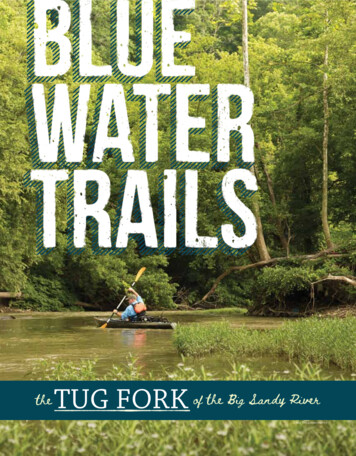
David Baker phototheTug Fork of the Big Sandy RiverObie Williams photo22 KentuckyAfieldAfieldSummer2018 201822 KentuckySummerfw.ky.govfw.ky.gov
Paddling the easternborderlands insearch of big fish andrich historyBy Lee McClellanhe violent collisionsbetween Earth’s tectonic plates andthe resulting uplifts that formed thesouthern Appalachians in Kentucky findtheir most stark and dramatic relief in easternmost Pike County. The nearly verticalmountains and narrow valleys provide vistasas arresting as any in the state.The Tug Fork of Big Sandy River,which forms part of the boundary betweenKentucky and West Virginia, flows throughthis maze of steep ridges. The Tug carriesin its waters healthy smallmouth bass, largeflathead catfish and the detritus of longterm human habitation of the valley. Theruggedness of the Tug Fork Valley rubbedoff on its settlers; this is a land of notorious family feuds, rugged individualism andlabor conflicts.It’s fitting that even the name of the river derives from the toughness of its people.In the winter of 1756, early in the Frenchand Indian War, a group of Virginia soldiersreturning home followed the North Fork of“Sandy Creek.” Their stomachs empty fordays, they boiled, then ate the leather straps,or “tugs,” that they used to tie gear to theirpacks. They also drank the “tug” soup in aneffort to avoid starvation.Afterward, soldiers began calling theriver Tug Fork.The river wears a long history of humanexploitation of the valley’s timber and coalresources. It is scarred, but not defeated,and in the process of healing. Water qualityin the Tug Fork has dramatically improvedduring the past few decades. It now supportsa population of smallmouth bass that rivals“fw.ky.govThe first riffle downstream of the HatfieldMcCoy Park is the longest of the float.any found in Kentucky.“The smallmouth bass in the Tug Forkare one of its most popular fish and doingvery well,” said Kevin Frey, Eastern Fisheries District biologist for the Kentucky Department of Fish and Wildlife Resources.“The fishery continues to improve from thelate 1980s.”Fisheries crews used to find 10-15smallmouth bass per hour while doingpopulation sampling there. “Now, we average 50 fish per hour,” Frey said. “The sizedistribution is really good. We have smallmouths in the 21- to 22-inch range on thelarger end. We have plenty of 3- to 4-poundfish to go after.”Muskellunge will be another top shelfpredator for Tug Fork anglers to pursue inthe coming years due to a joint stocking effort between the West Virginia Departmentof Natural Resources and Kentucky Fishand Wildlife.Dave Dreves, assistant director of fisheries for Kentucky Fish and Wildlife, saidthe department stocked 100 muskellungemeasuring 13 inches in May 2017, alongwith 25,000 muskie fry at Hatfield-McCoyPark in McCarr. A similar stocking occurred at Burnwell whilethe river near South Williamson received 190 ofthe larger muskellunge,along with 52,300 fry.“This year, in latesummer, we are going to stockThis is a land of notorious family feuds,rugged individualism and labor conflicts.“TObie Williams photo9-inch muskellunge in partnership withWest Virginia. Each state will contribute195 fish,” Dreves said. “We intend to keepdoing this through 2021.”Water Flow MattersTwo floats showcase the history andbeauty of the Tug Fork Valley. One is a shortbut productive journey through the heartof the Hatfield-McCoy feud country. Theother is a longer voyage featuring excellentscenery and smallmouth bass fishing.Paddlers must consult the weatherforecast before heading out. Runoff fromthe steep mountains of the headwaters canturn the normally placid river into a muddy,foamy froth in a matter of hours.“You’ll do better if the Tug is clear, soyou can pinpoint where to cast and fish,”Frey said.Finding the flow’s sweet spot for productive fishing and enjoyable floating is thekey for paddling the Tug. Go online to theWilliamson gauge on the United StatesGeological Survey streamflow webpage tofind the latest information. Flows of 200 to700 cfs (cubic feet a second) offer the bestconditions for paddling and fishing. Paddlers will likely need to walk their boatsover drops and shallow shoals if flows arelower. The Tug’s mild drops are perfectfor families, beginners and intermediate paddlers.Hatfield-McCoyPark to MatewanThe first float begins atthe Hatfield-McCoy Park inthe McCarr community inPike County. It ends aboutthree miles downstream at a publicramp in Matewan, West Virginia.To reach the Hatfield-McCoy Park,take U.S. 119 east from Pikeville for approximately 23 miles. Turn right ontoSummer 2018 Kentucky Afield 23
Obie Williams photoKY 319 for 7 miles then left (east) on KY1056 for 3 miles. The parking lot for thelaunch lies just after the playground andpaved walking path at Hatfield-McCoyPark.Paddlers will need to leave a shuttle vehicle at the take-out, located across the stateline and a few miles away. To reach the takeout, take KY 1056 across the Tug into WestVirginia. After 1 mile, turn left onto WV 49at the T-intersection. After 2 miles, look fora tennis court and playground on the left. Aroad beside the tennis court leads you to thetake out.The route to the put-in is steeped withthe history of the Hatfield-McCoy feud, amurderous conflict between two familiesthat lasted nearly three decades.The drive, followed by the float downthe river, touches many significant sites ofAmerica’s most notorious feud. A little history helps paddlers understand the underpinnings of the conflict along the way.Driving on KY 319 brings travelers through the coal town of Hardy. On24 Kentucky Afield Summer 2018its southern fringes awaits the site of theRandolph McCoy Cabin. Here, an attackby nine members of the Hatfield family onJan. 1, 1888, resulted in the deaths of twoof Randolph McCoy’s children. The attackalso severely injured McCoy’s wife, Sally.Just down from the junction of KY 319and KY 1056 stands the cabin of the Rev.Anderson “Preacher Anse” Hatfield, whoserved as a justice of the peace. This is thesite of the Hog Trial, in which Randall McCoy accused Floyd Hatfield of stealing ahog. McCoy’s loss at the trial intensified thefeud between the families.Also near the cabin is the site of the“Election Day Fight” in early August 1882.Tolbert McCoy jumped Elias Hatfield, thebrother of “Preacher Anse” Hatfield, over 1.75 owed Tolbert from the sale of a fiddle.Family member Ellison Hatfield joined thefight. Tolbert, along with two of his brothers, stabbed Ellison 26 times then shot himfor good measure. Ellison died two dayslater, leading to the famous “Paw Paw Incident” in which the McCoy brothers wereThe Matewan floodwall illustratessignificant events in the town’s history.tied to trees and shot.After putting in at Hatfield-McCoyPark, this short float gives anglers time topaddle upstream past the old railroad bridgeand fish the long hole back to the launch.Anglers should fish the rocky mouth ofBlackberry Creek with a 3-inch, electricblue swimbait. This imitates some of the native shiners that smallmouth bass favor.Local anglers say this hole holds flathead catfish topping 20 pounds. “The catfish in the Tug are phenomenal, both channel and flathead catfish,” Frey said. “Whenwe electroshock the river during populationsampling, the channels are so thick youcould practically walk across the river onthem. There are plenty of numbers of channels from 16 to 24 inches, prime eating size.”Target flatheads in rocky areas with livebait such as shiners, bluegill and green sunfish on a slip-sinker rig. Anglers have goodmotivation to try this kind of fishing. “Wefw.ky.gov
fw.ky.govRandolph MccoyccPatriarch of the McCoy Clanvolatile country“Devil Anse” HatfieldPatriarch of the Hatfield ClanPhotos courtesy www.tourpikecounty.comThe dramatic events that unfolded during the Hatfield and McCoy feud havebecome part of Kentucky’s lush historical tapestry. Landmarks highlighting violentconfrontations between the two families are scattered throughout eastern PikeCounty. Many are open to the public.Obie Williams photoFEUD destinations(Above) The Randolph McCoy cabin, and site of the famous hog trial, can beaccessed off of KY 319, just before its intersection with KY 1056. (Below) The siteof the Paw Paw Incident, where the lives of three McCoys were taken by a posseled by “Devil Anse” Hatfield, is now a public park in Buskirk, Kentucky. It can beaccessed via KY 1056 between McCarr, Kentucky and Matewan, West Virginia,and can also be seen while floating the Tug Fork (see map for exact location).Obie Williams photoregularly see flatheads above 30 pounds, andup to 45 pounds or so,” Frey said.Good smallmouth bass fishing beginsat the first drop downstream of the launch.Cast a beaver-style creature bait in hues ofgreen pumpkin and blue in the flowing water just above the drop. A 1/8-ounce, greenpumpkin or black skirted double-tailed grubalso works well here.Paddlers negotiating the braided water just downstream of the launch shouldtake the chute on river left. What followsare a series of mild riffles bordered by water willows that hold smallmouth bass. Thisis a good place to work a black, 4-inch finesse worm rigged on a 1/8-ounce jig. Blackis a productive color for smallmouth bass insummer and fall.The Tug next flows over a long shoalbefore taking a hard left. Shoals like thisare good spots to work medium-running,crawfish-colored crankbaits.Paddlers soon will see the Matewanfloodwall in the distance. The wall featuresmurals of the Hatfield-McCoy feud, theBattle of Matewan labor dispute and mountain scenes.The flat on the left of the bend is thesite of the Paw-Paw Incident. After EllisonHatfield’s murder by three McCoy brothers,a posse lead by “Devil Anse” Hatfield, thecousin of “Preacher Anse” Hatfield, captured the trio. They tied the McCoy brothers to the bankside paw paw trees and shotthem.The bank below this area is a goodplace for anglers to beach their boats andfish. Work the current above and below therapids at the floodwall with an electric blueswimbait for smallmouth bass.The Tug deepens with a rocky bank onriver right after flowing underneath the KY1056 bridge. “This stretch of river is knownfor big flathead catfish,” Frey said. “Thereare also some big channel cats through thereas well.”At the end of the deep hole, the riverconstricts and flows over a riffle before disappearing around a hard right bend. Thedrop downstream of the bend offers some ofthe best smallmouth bass water on this float.Creature baits fished along currentseams draw strikes here. This is also a goodplace to fish a swimbait. It’s worth it to pullover and wade fish here.The Tug then flows through deeper water that holds flathead catfish. Target the25SummerSummer20182018 KentuckyKentuckyAfieldAfield 25
242.85 milesKY 240Road AccessKY 622Road Access32404.5""6"MatewanRamp!Miles"KY 240Road Access24037.63644-82.173584"Goodrum RoadRoad AccessDouble train bridgeto take out.85 miles0DoubletrainbridgegigeBf thorkFoHighwayTrain trackserivyR1.5dSa nTuSIMPSONCOUNTY492601NKLIN622McCarrto MatewanALLENDouble COUNTYKY/WV bordertrain34.5aWEST VIRG496Miles!bridgeMATEWAN1056 bridgeto double trainbridgeCarry down access1.25 miles32411056WEST VIRGINIA1332BUSKIRK5851056 bridgeto double trainbridgePut10561mMATEWAN651.25 miles100Tuig SeBhtoforkgF231"Woody AtkinsonRoad AccessTug ForkerivyRdn1056Paw 1 mile1056McCARR1.5Put in to1056 amp!37.610924-82.169801Sandy RiverBigthefoo rkTug FBlackberryCreek0.5rocky areas and woody cover for these rugged fighters.Soon, paddlers will see the doublebridge of the Norfolk Southern Railroad.The Tug constricts and increases its velocityhere. The substrate also grows rocky: primesmallmouth bass habitat.“The area around the railroad bridgeis known for rock bass and big smallmouthbass,” Frey said.Wade fish the rock bar downstream ofthe bridge thoroughly. Drift a black finesseworm in the current, letting it gently touchthe bottom occasionally.The river then bends gently left andflows over two small drops that hold smallmouth bass. It soon gains depth with somerocky banks on the outside bend, prime flat-26 Kentucky Afield Summer 20181Mileshead catfish territory.The take-out on river right is easy tomiss. Watch out for broken glass around theaccess.Matewan to Williamson/SouthWilliamsonThe second float begins at the Matewanaccess. Paddlers can end their trip after 10miles at Williamson, West Virginia, or goanother 2 miles to the concrete boat rampin South Williamson, Kentucky. Paddlersshould be on the water early and preparedto leave late due to the length of this float.This deeper float features more paddling than fishing. Wise anglers shouldconcentrate on the flowing water upstreamand downstream of stream drops and enjoyOldrailroadbridgeObie Williams photothe scenery and paddling through the manylong, tranquil deep holes in this stretch ofwater.The first bend downstream of the Matewan access features gravel bars and flowingshoals that hold smallmouth bass. This bendforms a horseshoe, with opportunities foranglers to beach their boats and thoroughlyfish the gravel bars with a green pumpkin,3/16-ounce, double-tailed skirted grub, or anelectric blue swimbait.Paddlers next encounter a straightstretch of medium-depth water. Paddlerswill pass under a golf course bridge and arailroad bridge. After a third bridge, theTug bends left and into the float’s bestsmallmouth bass water. Anglers shouldpound gravel bars downstream of the bendwith their skirted grub.The Tug takes a hard right and flowsover a deep, aquamarine hole. A long gravelbar lies on river left. This is Burnwell Beach.Aside from stopping to admire its arresting mountain views, the beach is a goodplace to pull over and wade the shallower,flowing shoal to cast for hefty smallmouthbass.Shoals and stream drops grow infrequent downstream of Burnwell Beach as theriver transitions to long holes and tranquilwaters. Anglers should paddle through thissection until the river bends hard left andbraids.fw.ky.govorTug Fk
9007231 23126292629"Smallmouth bass in the Tug areARREN"(Left)" (Right)abundant in size and numbers.OUNTY"The low head dam in Williamson must beportaged around. A distinct metal wall"marks" the dam’s location.Phil MoorePark (P2)a mile to reach a concrete boatramp in South Williamson,Kentucky. The ramp on riverleft, just downstream of a hard65right bend and deep hole.Vehicles for this shuttleKY 240BOWLING GREENRoad AccessHere, rockybars hold smallmouth bass.should continue on WV 49KY 622cess"with the skirted grubProbe theseareasfrom the Matewan access. The" andRoad Access"240" "the finesse worm. In late summer and KYfall,road follows the river for apBOWLING GREENRoadAccessKY 240let these lures reston the bottom and let "theproximately 9½ miles. Turn leftRoad AccessGoodrum Roadcurrent flutter them.Smallmouthbass oftenonto""Road Access" U.S. 52 and continue forWARRENGoodrum Road Road Access resist this presentation." cannottwo miles. Turn left onto Har"LeeMcClellanphotoCOUNTY some of thisvey Street Philandcross the river"The next mile or so featuresMooreWoody AtkinsonPark (P2)"U.S.Road Access infrequent shoals rimmed with section’swaAnglers maypark behind"the water into Kentucky. Cross119 and continue65Phil Mooreter willow. Work a 3-inch, sexy shad-colored plant and carry their boats out via a path on Second Street. Turn" Parkleft(P1) onto Centralswimbait in the deep flowing water near the behind a metal retaining wall upstream of Avenue (KY 292) for slightly more thanshoals, and along the water willow beds. WOODBURNthe dam. Paddlers maybefore restau portage on" also" ei- half65a mile then turn right," sign markingThe Tug flows gently until a railroad ther side of the dam." Local anglers report rant. Look for a small whitebridge appears in the distance, followed by catches of hefty smallmouth bass in excess" the entrance.ALLENKY 240 Fork combines history, scenThe Tugthe U.S. 119 Bridge. Paddlers must pre- of three pounds below the "dam.Road AccessCOUNTY WOODBURNeryandexcellentpare for a dangerous low head dam awaiting"For this shuttle, continue on WV 49KY 622" fishing in the eastern" mostRoad Access"NKLINsectionofKentucky.Itisworththe KYdrivetothem a few hundred yards upstream of the from the Matewan access. The road follows"240Road AccessDamtotakeouthighway bridge.thisincrediblysceniccornerofthestate.the river for approximately 9½ miles. Turn" nGoodrum RoadThis dam was created in the 1980s to left onto U.S. 52 and continuefor two miles.1.5milesSadler Ford/Clay" Road AccessStarks Road Accessserve the water treatment plant of Wil- Turn left onto Vinson Street, then an im- Learn more about the Hatfield-McCoy WILLIAMSON"liamson, West Virginia. Local officials are mediate left onto East Third Avenue to the Feud and more of what Pike County has"to AtkinsonWoodystudying ways to make the passage safer as parkingSIMPSONarea.offer LowonlineRoad Accesshead at tourpikecounty.com, or calldamthey create a water trail for the Tug"Fork.Boatersalso may paddle for more than (606) 432-5063.COUNTYPhil MoorePark (P2)Phil MoorePark (P1)622Phil MoorePark 1ALLENCOUNTY2629Phil MoorePark (P2)68242KY 240Road Access324123131WKY 622Road Access2629WARRENCOUNTY88432419007Phil MoorePark (P1)62296162288496242SIMPSONCOUNTYKY 240Road Access24013325851332240Goodrum RoadRoad AccessSadler Ford/ClayStarks Road Access5852312601Woody AtkinsonRoad Access622240WEST tmore FordRoad AccessBurnwell Bto dam2601!Dam to take outLow LIAMSONWilliamsonTake Out(Water Plant)FRANKLINKY/WV borderHighwayUS HighwayTrain tracksLow head damKENTUCKY2924936221005.5 miles1.54119Burnwell Beachto dam!02922601!1191332585MatewanCOUNTYtoSouth Williamson525252RailroadbridgeDitmore FordRoad Access37.669468,-82.275451Railroadbridge5.5 miTugForkSIMPSON11711008WILLIAMSON36221001.5 miles1.56Miles1434FRANKLIN4.56Miles119!Carry down access319KENTUCKYMatewan put in toBurnwell Beach0119495.1 bridgerk ofth e B ig S a -82.173584MATEWANMilesObie Williams maps49fw.ky.govSummer 2018 Kentucky Afield 27
river right after flowing underneath the KY 1056 bridge. "This stretch of river is known for big flathead catfish," Frey said. "There are also some big channel cats through there as well." At the end of the deep hole, the river constricts and flows over a riffle before dis-appearing around a hard right bend. The