Transcription
Geomorphology 82 (2006) 4 – 15www.elsevier.com/locate/geomorphReconsidering Himalayan river anticlinesDavid R. Montgomery ⁎, Drew B. StolarQuaternary Research Center and Department of Earth and Space Sciences, University of Washington, Seattle, WA 98195, USAReceived 2 July 2004; received in revised form 27 August 2005; accepted 27 August 2005Available online 5 June 2006AbstractThe observation that major Himalayan rivers flow parallel to and down the axis of anticlines oriented transverse to the primarystructural grain of the range has puzzled geomorphologists for decades. Although there is a general consensus that the courses oftrans-Himalayan rivers predate the Himalayan orogeny, the close association of rivers and structural highs would not be expected toresult from the superposition of rivers onto pre-existing structures. Moreover, in the past several decades structural studies haveshown that the development of river anticlines represents the most recent phase of deformation in the range. It is proposed thatHimalayan river anticlines are the consequence of focused rock uplift in response to significant differences between net erosionalong major rivers and surrounding regions. This hypothesis is supported by large gradients in observed and predicted erosion ratesacross major Himalayan rivers and by results from an isostasy-driven model, which requires relatively low flexural rigidities tomatch the wavelength of Himalayan river anticlines. Whether the amplitude of these structures is due to isostasy or also reflectsactive crustal channeling is not well-constrained, but given the uncertainty in the flexural rigidity and in the local and far-fielderosion rates, both possibilities remain viable explanations. Given the observed correlation between the Arun River anticline andlocal rainfall maxima, it is proposed that Himalayan river anticlines are the expression of a relatively fine-scale linkage betweentectonics, erosion and climate superimposed on the broader and older canvas of the Himalayan orogeny. Finally, it is suggested thatthe development of river anticlines represents one example along a continuum of features arising from different degrees of erosionstructure coupling in active orogens. 2006 Elsevier B.V. All rights reserved.Keywords: Bedrock erosion; River anticline; River incision; Himalayan rivers; Arun1. IntroductionClassical explanations for spatial relations betweenrivers and geologic structure involve rivers passivelyfollowing structural lows, faults or zones of weakness,or maintaining their grade across developing structuressuch as growing anticlines. Cases where rivers flowalong structural highs are known as river anticlines and,as noted by Oberlander (1985), are common along⁎ Corresponding author.E-mail address: dave@ess.washington.edu (D.R. Montgomery).0169-555X/ - see front matter 2006 Elsevier B.V. All rights an rivers. Wager (1937) originally noted thatthe Arun River flows along synclines in Tibet and thendrops through the Himalaya in a gorge along an anticlinecarved into hard, deeply-exhumed gneiss and suggestedthat the most recent phase of Himalayan uplift was dueto isostatic response to incision of deep river valleys.The amplitude and wavelength of anticlines along theIndus and Arun rivers are apparent on maps and crosssections reported in previous work. Cross-sectionsacross the Indus River (DiPietro et al., 1999) show theriver centered on the crest of a 10-km amplitudeanticline with a wavelength of 50 to 60 km. Meier and
D.R. Montgomery, D.B. Stolar / Geomorphology 82 (2006) 4–15Hiltner's (1993) map of the distribution of metamorphicunits and associated cross-section through the ArunTectonic Window shows an anticline with an amplitudeof about 10 km and a wavelength of about 30 km.Oberlander (1985) also estimated the amplitude of theArun River Anticline as 10 km. The mapping ofSchelling (1992) revealed that the Arun River Anticlineis actually one of the several in the region and that theadjacent drainage divides coincide with north–southtrending synclines. Also, the area of deeply exhumedrocks along the gorge of the Tsangpo River in theeastern Himalayan syntaxis is a roughly 60 to 80 kmwide antiform (Burg et al., 1997). Hence, it appears thatlocal antiformal structural highs along major Himalayanrivers have wavelengths of 30 to 80 km.Recent work on linkages between spatial patterns inerosion rates and rock uplift suggests that the geographyof erosion may in some circumstances influence, or evencontrol the evolution of geological structures. Zeitler etal. (2001), for example, proposed that focused bedrockriver incision can concentrate rock uplift and exhumation, which in turn advects hot weak rock toward thesurface and results in a positive feedback and development of a deeply-exhumed antiformal metamorphicmassif. Although the idea that progressive river incisioninto the bedrock could generate river anticlines wasrejected by Oberlander (1985) in his interpretation of theorigin of Himalayan river anticlines, classical ideas donot provide satisfying explanations for these features.Most workers view the crust as rigid, which implies thatthe incision of short-wavelength river valleys wouldexert little influence on crustal deformation. However,Simpson (2004) recently simulated the development ofanticlines transverse to rivers using a landscapeevolution model and found that “river incision canhave a major influence on deformation of the surrounding crust if incision occurs at the same time that the crustis deforming plastically in response to regionalcompression.” In this paper prior work on riveranticlines is reviewed and the conditions are exploredunder which one would expect the potential for rivers toinfluence the growth of local geological structuresthrough sustained differences in bedrock erosion.2. Previous workAttempts to explain and systematize genetic relationships between rivers and geologic structure can betraced back to Powell's (1875) classification of valleysinto antecedent and consequent types. Since Powell'srecognition that valleys could either pre-date (antecedent) or post-date (consequent) the development of the5geological structures over which they flow, relationshipsbetween rivers and geological structure have beenactively investigated (e.g., Tucker and Slingerland,1994; Norris and Cooper, 1997; Pavlis et al., 1997;Burbank et al., 1999). The case of rivers occupyingstructural lows or the axis of synclines requires nospecial explanation, particularly for alluvial rivers in riftzones or those trapped in structural depressions. Incontrast, several general explanations have been developed for the less intuitive case of rivers that flow acrossor along structural highs, particularly rivers flowingalong the crest of anticlines.The most common explanation for the orientation ofrivers flowing transverse to geologic structure is that ofdrainage superposition, in which the course of the riveracross the geological structure was inherited. Antecedent rivers also may cross geological structures whererivers are competent enough to cut either acrossstructures exposed by progressive bedrock erosion orthrough rising structures (e.g., Burbank et al., 1999).However, no particular relation is expected betweenstructure and drainage in both the case where a rivermaintains its course while structures rise around it, andthe case where the river's course is superimposed onunderlying rocks as the river cuts down into them.Rivers that bisect the Zagros Mountains are theclassic example of drainage superposition (Oberlander,1965), and the major drainages of the Himalaya, whichgenerally flow transverse to the orientation of the range,are also thought to have been formed by antecedentrivers that flowed across the edge of the rising TibetanPlateau at the onset of and during the Himalayanorogeny (Wager, 1937; Gansser, 1964; Oberlander,1985). Alvarez (1999) and Simpson (2004) describeadditional examples of relationships between transverserivers and structure highs in the central Apennine foldand-thrust belt, the Pyrenees, the Swiss and FrenchAlps, and the central Andes. After noting an “uncannyhoming instinct of larger streams” to find and flowthrough anticlines despite the presence of proximalstructural lows that the rivers appeared to avoid,Oberlander (1985) offered an elaborate model for howa combination of drainage antecedence and superposition could lead to rivers flowing through structural highsin rocks with strong contrasts in erodibility. Alvarez(1999), however, showed that the particular stratigraphicsequence invoked by Oberlander as required for such ascenario in the Zagros Mountains was lacking in thecase of the Appennines, despite the development ofsimilar structures. Moreover, in the general case ofdrainage superposition there should not be any particular relation between river courses and the geological
6D.R. Montgomery, D.B. Stolar / Geomorphology 82 (2006) 4–15structures onto which they were superimposed. Neithershould there be any particular relation for pre-existingrivers that maintained their grade across developing oractive structures.In contrast, differential erosion should result in closeassociation between rivers and structural highs whereweak rocks become exposed at the surface and traprivers into flowing along the core of an erodinganticline. In such cases, the deformation leading to thedevelopment of the geological structures pre-dates theestablishment of the drainage system. The Appalachianmountains contain numerous well-known examples ofrivers flowing in such structurally controlled settings, astaught in introductory geomorphology classes.River anticlines associated with salt dome structuresalong the Colorado River near the Colorado–Utahborder present a more unusual example of “salttectonics” driven by river incision (Harrison, 1927).There, a series of saline anticlines, or salt domes have upto 300 m of structural relief and are centered on the river.Harrison (1927) explained the development of thesefeatures as due to isostatic response to differentialerosion along the river. In his view, as the river cut itscanyon the progressive development of differentialloading between the canyon walls and the valley bottomtriggered the buoyancy-driven rise of underlying saltalong the river — the locus of focused erosion.The river anticlines along the Colorado River in thecentral Grand Canyon provide another unusualexample of geological structures formed in responseto river incision (Huntoon and Elston, 1979). At thebase of the Grand Canyon, strata of the CambrianMauv Limestone and the underlying Cambrian BrightAngel Shale are locally warped into river-parallelanticlines with 5–10 m amplitudes and 200–400 mwavelengths, and which follow the course of the riveraround bends. Huntoon and Elston (1979) showed thatthese features were likely an unloading phenomenondue to the stress gradient induced by the juxtapositionof the 650-m-high canyon walls and the unloadedvalley floor.Himalayan rivers provide another example of apeculiar, and unexplained, relationship between rivercourses and geologic structure. Major Himalayan riversrun transverse to the primary geologic structures acrossthe range, from the edge of the Tibetan Plateau acrossthe primary thrust faults that parallel the general trend ofthe range itself. In contrast to this general trend, Bordet(1955) noted that the axes of the Arun and Karnali riversin the eastern Himalaya followed “transanticlines” thatcrossed the primary structural trend in the range. Whilethere appears to be a broad consensus that trans-Himalayan rivers are antecedent, Meier and Hiltner(1993) showed that the deformation associated with thegrowth of the river-parallel anticline along the ArunRiver is the youngest regional deformation and that itpost-dates both metamorphism and development ofcollision-related structures. This precludes the possibility that the river anticline is simply part of the inheritedgeologic structure beneath an antecedent river, andalong which the modern river coincidentally flows.According to Krishnaswamy (1981) many of the majorrivers of the central Himalaya follow range-transversefolds that are the result of the youngest deformation inthe range. Through examination of geological maps,Oberlander (1985) found that in addition to the Arunand Karnali rivers, the Tista, Kali Gandaki, and Sutlejrivers all follow anticlines oriented transverse to theprimary structural grain of the range. The Indus andTsangpo rivers also flow through deeply exhumedstructural highs where they turn abruptly and flowthrough steep gorges to cross the Himalaya (Burg et al.,1997; DiPietro et al., 1999). If the major transHimalayan rivers are antecedent, as generally agreed,then why do they coincide with the youngest deformation in the range — deformation transverse to theprimary structural grain?Traditional explanations do not satisfactorily explainthe development of Himalayan river anticlines. Thehigh-grade metamorphic rocks exposed in the core ofthese anticlines are not relatively weak, as would berequired to explain them as a simple product ofdifferential erosion, like in the Appalachians. Anticlineswith amplitudes larger than the relief of the valleycannot be generated by stress release, as seen in how theriver valley dwarfs the small river anticlines along theColorado River. In addition, because the anticline alongthe Arun River is younger than both the regionalmetamorphism and collision-related structures, the rivercould not have been simply superimposed on anunderlying structure. Oberlander (1985) nonethelessfavored drainage superposition as the most likelyexplanation for why Himalayan rivers are perched ontop of large folds, although he recognized that the strongassociation of the river with these structures presented afundamental problem to this interpretation.[U]nless we accept the presence of gigantic “riveranticlines” in the Himalaya, produced by off-loadingas canyons are cut, we have a problem of reconcilingso-called “antecedent” streams, that should conspicuously disregard structure, with an apparentstream preference for a particular structural environment. (Oberlander, 1985, p. 159)
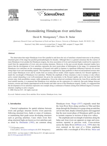
D.R. Montgomery, D.B. Stolar / Geomorphology 82 (2006) 4–15Wager's original idea that the great height of theHimalayan peaks was due to local isostatic response tounloading would require a low flexural rigidity in aregion with substantial crustal thickness (Montgomery,1994). Despite the lack of satisfying answers as to howHimalayan river anticlines formed, the problem virtuallylay dormant until Zeitler et al. (2001) proposed thatrapid river incision into bedrock contributed to theformation of active crustal aneurysms in the Himalayansyntaxes. Finlayson et al. (2002) subsequently suggested that non-uniform bedrock erosion might beresponsible for the spatial association of zones ofpredicted rapid river incision and both syntaxialmetamorphic massifs and Himalayan river anticlines.Exploring the scenario dismissed by Oberlander,Simpson (2004) addressed the potential for anticlineformation in response to river incision through numericalexperiments using a coupled mechanical-surface processmodel. Specifically, he coupled a thin elastic-plasticplate with a surface process model that included bothhillslope diffusion and river incision. He assumed arelatively stiff crust and considered three combinationsof boundary conditions: (i) localized river incisionduring horizontal compression; (ii) flexural response toriver incision in the absence of regional compression;and (iii) regional compressive deformation without riverincision. He found that the response to river incision inthe absence of compression was minor, amounting tostructurally negligible amounts of rebound in the specificscenario he reported, and that incision under regionalcompression produced doubly plunging transverseanticlines with structural culminations that coincidedwith the location crossed by the river. Based on thisanalysis, he concluded that “whether rivers exert aninfluence on local deformation depends critically on thetiming between river incision and regional deformation”(Simpson, 2004).Here further consideration is given to the question ofwhether spatial variability in bedrock erosion could,during progressive unroofing over geologic time, lead tothe development of river anticlines such as thosereported along major Himalayan rivers.3. Study areaThe Arun River is the focus because it is the classicexample of a river anticline, and because of theavailability of regional geologic mapping that depictsthe axes of synclines and anticlines transverse to therange. Schelling (1992) mapped the geology of easternNepal from the Kathmandu Valley to the Sikkhim borderand from the High Himalaya to the Ganges Plain (Fig.71A). The area has the well known primary structuraland stratigraphic grain found throughout much of therange — proceeding south to north, the alluvial plain ofthe Ganges basin, the Main Frontal Thrust (MFT), theSub-Himalayan sequence of sedimentary rocks, theMain Boundary Thrust (MBT), the Lesser HimalayanSeries rocks, the Main Central Thrust (MCT), and theHigher Himalayan crystaline and Tibetan rocks. Although the primary structural grain parallels the strike ofthe range, structural windows including the ArunTectonic Window (Meier and Hiltner, 1993) exposerocks below the MCT, which is deformed in a series ofanticlines and synclines, the axes of which roughlyparallel major rivers and drainage divides, respectively.Annual rainfall in the region exhibits a double-bandpattern typical of the Central and Eastern Himalaya (Fig.1B; Anders et al., 2006). Superimposed on the decreasein rainfall with increasing elevation are maxima on thelowest flanks of the range and on slopes just south of themajor peaks. This northern band is particularly pronounced in major river valleys like the Arun, which actas conduits for northward transport of monsoonalprecipitation (Thiede et al., 2004; Anders et al., 2006).The result is that local precipitation within the gorge ofthe Arun River is several times greater than insurrounding areas.4. ModelCalculating landscape-scale erosion rates in steepterrain typically involves predicting long-term erosionrates set by rivers as a function of discharge, slope, andbedrock erodibility. We used the unit stream power (Ω)model recently proposed by Finnegan et al. (2005) thatincorporates local changes in channel width viaX ¼ qgQS W ¼ kQ5 8 S 19 16ð1Þwhere ρ is the density of water, g is gravitationalacceleration, Q is fluvial discharge, S is river slope, W isthe channel width, and k is a proportionality constant.The discharge Q is estimated from a 4-year average ofprecipitation rates derived from Tropical RainfallMonitoring Mission (TRMM) radar data (Anders etal., 2006). The SRTM 3 arc-second digital elevationmodel (nominal 90-m grid resolution) is utilized and thechannel network is defined as those grid cells withcontributing areas greater than 10 km2 to restrict theanalysis to main stem channels and large tributaries.Doing so avoided application of Eq. (1) to debris-flowdominated headwater channels, hillslopes, and steepvalley walls. Standard pit-filling techniques on the ArunRiver resulted in long reaches of flat channel. These
8D.R. Montgomery, D.B. Stolar / Geomorphology 82 (2006) 4–15Fig. 1. (A) Geologic map of eastern Nepal (after Schelling, 1992), and (B) precipitation map draped on shaded DEM of the area. Triangles showlocations of major peaks (EV Everest; MK Makalu; SP Shisha Pangma). Inset shows location of study area (NP Nepal; BH Bhutan; BA Bangladesh). Stratigraphic abbreviations are as follows: GB Ganges Basin, SH Sub-Himalaya; LH Lesser Himalaya; HH HighHimalaya; TH Tibetan Himalaya. Structural abbreviations are: MFT main frontal thrust; MBT main boundary thrust; MCT main centraldetachment; STD South Tibetan detachment; TKT Tamar Kola Thrust.sections were removed, and channel slopes werecalculated at the remaining points by linear regressionof the elevation profile over 1-km and 5-km lengthscales. Because information is lacking on the spatialdistribution of k an erosion index given byEI ¼ X k ¼ Q5 8 S 19 16ð2Þwas used to generate a predicted pattern of spatialvariability in erosion rates.A simple model was also used to examine thehypothesis that isostatic rebound from bedrockerosion concentrated along a river valley coulddrive the development of an anticlinal pattern ofrock uplift centered along the river. Specifically, wecalculate the isostatic response to differential erosionbetween a uniform erosion rate in the far field and ahigher rate within a river valley of width L. The netdifference between near-field and far-field erosion
D.R. Montgomery, D.B. Stolar / Geomorphology 82 (2006) 4–15(ΔE) is assumed not to influence the flexural rigidity.In such a scenario, both the valley width and theflexural rigidity of the continental crust influence thelength scale across which differential rock uplift willbe spread in response to concentrated bedrock riverincision. Simply put, larger valleys produce longerwavelength responses than smaller valleys, andweaker crust produces both narrower wavelengthand higher amplitude response.The flexural rigidity of the crust (D) depends on itseffective elastic thickness (T) and is given byD ¼ ET 3 12ð1 m2 Þ;ð3Þwhere E is the elastic modulus (E 8.35 1010 Nm 2)and ν is Poisson's ratio (ν 0.25). Thin or mechanically weak crust will concentrate isostatic rock upliftnear the area of greatest erosion, whereas thick orstrong crust will disperse the response across muchbroader areas. In addition, substantial crustal strengthwill reduce the magnitude of isostatically-induced rockuplift to less than expected for the case of Airyisostasy that replaces roughly five-sixths of the rockstripped by erosion.The solution for the isostatic response, w(x), as afunction of distance x from the valley center can beseparated into expressions valid inside and outside theriver valley, respectively (Hetenyi, 1946): !LL0 x L 2 : wðxÞ ¼ awo e ð2 xÞ a cos 2 xa! Lþx ðL2þxÞ aþecos 2 2 ;að4aÞx L 2 : wðxÞ"!!#LLLLþxx ¼ awo e ð2þxÞ a cos 2 e ð x 2Þ a cos2 ;aað4bÞwhere α is the flexural parametera ¼ ð4D qm gÞ1 4 ;ð5Þand wo is the isostatic response at the valley center dueto a point loadwo ¼ qc gDEa3 8D:ð6Þ9The wavelength (λ) of the isostatic response can bederived from Eq. (4b), and is given byk ¼ 2atan 1 1 eL aLcot:2a1 þ eL að7ÞSimilarly, the maximum amplitude of the response,which occurs at the valley center (x 0), can be extractedfrom Eq. (4a): qL Lwmax ¼ DE c 1 e 2a cos:ð8Þ2aqmNon-dimensionalization of Eq. (8) yields the amplitude of the isostatic response as a proportion of the totalamount of material eroded: L⁎ ¼ wmax ¼ qc 1 e L2a coswmax:ð9Þ2aDEqmGiven independent knowledge of the differences innet erosion (ΔE), Eq. (9) can be used to estimate theamplitude of the resulting geological structure inrelation to the thickness of the material removed.5. Model resultsPredicted values of the erosion index are greatestalong the Arun River where it flows through its gorgein the northern half of the modeled area (Fig. 2). Theaxis of the anticline in the Arun Tectonic Windowtracks the zone of high predicted erosion potential inthe northern part of the area (through the gorge) wherethere is a more than two order of magnitude differencein the erosion index between the main stem and theupper reaches of the surrounding tributaries. Inparticular, the erosion index progressively increasesdown tributaries to the gorge across a roughly 10–20 km wide zone of high erosion potential centered onthe gorge of the Arun River. However, the zone ofhigh contemporary erosion potential only extendsabout 10 km south of 27.5 N.The wavelength of flexurally-mediated isostaticresponse predicted by Eq. (7), and therefore thewavelength of any anticline produced by such response,is essentially independent of valley width for D 1021 Nm, but becomes increasingly sensitive to variations invalley width for D 1021 N m (Fig. 3). For valley widthsof 10 to 20 km, a reasonable range for large Himalayanvalleys and roughly the scale of the zone of high EIpredicted along the Arun River, Eq. (7) predicts that the
10D.R. Montgomery, D.B. Stolar / Geomorphology 82 (2006) 4–15Fig. 2. (A) Shaded relief map of the Arun gorge area based on the 3 arc-second SRTM DEM); (B) Erosion index (EI) map based on 1 km slopeaveraging within channel network defined by grid cells with drainage area 10 km2; (C) comparable EI map based on 5 km slope averaging.zone of rock uplift in response to localized river incisionwill have a wavelength of about 50 km to 90 km forflexural rigidities of 1020 to 1021 N m. For the samerange in valley width and rigidity, the predictedamplitude of the isostatic response, expressed as afraction of total amount of material removed, rangesfrom 0.2 to almost 0.7 (Fig. 4). However, as is apparentfrom Figs. 3 and 4, the full range of potential linkagesFig. 3. Wavelength of flexural istostatic rebound (contours in units ofkm) as a function of valley width (km) and flexural rigidity (N m), aspredicted by Eq. (7).between focused bedrock erosion and structural response manifest across just two orders of magnitude inflexural rigidity (from 1020 to 1022 N m), makingindependent knowledge of this often poorly constrainedparameter of central importance to understanding therole of isostatic response in the development ofHimalayan river anticlines.Fig. 4. Non-dimensional magnitude of flexural rebound (contoursexpress rebound as a proportion of the thickness of material eroded) asa function of valley width (km) and flexural rigidity (N m), aspredicted by Eq. (9).
D.R. Montgomery, D.B. Stolar / Geomorphology 82 (2006) 4–1511Comparison of whole-basin erosion rates to localriver incision rates supports the prediction of greaterthan-average local river incision along portions of majorHimalayan rivers (Table 1). Whole-basin erosion ratescompiled by Lavé and Avouac (2001) for elevenHimalayan drainage basins range from 0.4 to 2.5 mmyear 1. In particular, they reported denudation rates of0.4 to 0.6 mm year 1 for the Arun River basin based onsuspended sediment yields. Schumm (1963) reported anaverage denudation rate of 1 mm year 1 for the KosiRiver (into which the Arun flows) based on previouslyreported reservoir infilling rates. Based on measuredsediment loads Das (1968) reported erosion rates of 0.5,1.0, and 1.4 mm year 1, respectively, for the Arun,Sapta Kosi, and Sun rivers, and 2.6 mm year 1 for themore anthropogenically disturbed Tamar River. Incontrast, Lavé and Avouac (2001) reported river incisionrates of 1 to 8 mm year 1 along the Arun River based on14C dated terrace elevations, and also presentedcalibrated models of river incision that predicted localincision of 4–8 mm year 1 along the Arun and otherrivers in the High Himalaya.Local river incision rates reported for the othermajor Himalayan rivers also are up to an order of6. DiscussionIn order for erosion to cause differential isostaticrock uplift, and thereby contribute to forming riveranticlines, erosion of the main river valley mustoutpace the background rock uplift rate and theerosion rate in surrounding areas. If the latter conditionwas not true, isostatic rebound would simply result inuniform rock uplift. In the steep topography of theHimalaya, and in particular along the steep rivergorges associated with river anticlines, the rate ofbedrock river incision is thought to set the loweringrate of the surrounding slopes (e.g., Burbank et al.,1996; Montgomery, 2001). Hence, rates of riverincision should set long-term bedrock erosion ratesalong major river valleys. Previous modeling oferosion potential using coarser-resolution DEMs –whether cast either in terms of estimated stream power,unit stream power, or basal shear stress – shows theArun, Indus, Sutlej, and Tsangpo rivers as havingsubstantially greater local erosion potential than theHimalaya in general (Finlayson et al., 2002), as alsosuggested by our finer-scale model for the gorge of theArun River.Table 1Himalayan erosion ratesAerial extentRate (mm year 1)MethodSourceWhole rangeHigh HimalayaHimalayan basins1.02.1–2.9Post 20 Ma exhumationGeochemical mass-balanceEinsele et al. (1996)Galy and France-Lanord (2001)Suspended sediment loadSuspended sediment loadSediment loadSediment loadSuspended sediment loadSediment loadDetrital thermochronometrySediment load10Be and 26Al on river sandsApatite fission trackApatite fission trackLavé and Avouac (2001)Lavé and Avouac (2001)Das (1968)Das (1968)Schumm (1963)Das (1968)Brewer (2001)Das (1968)Vance et al. (2003)Thiede et al. (2004)Sorkhabi et al. (1996)14Lavé and Avouac (2001)Lavé and Avouac (2001)Lavé and Avouac (2001)Pratt-Situala et al. (2004)Burbank et al. (1996)Shroder and Bishop (2000)Jain et al. (2000)Burg et al. (1997)Lavé and Avouac (2000)Whole basins and local far-field erosion ratesHimalayan basins0.4–2.5Arun River0.4–0.6Arun River0.5Sapta Kosi River1.0Kosi River1.0Sun River1.4Marsyandi River1.5–2Tamar River basin2.6High Himalayan basins2.7 0.3Sutlej High Himalaya1.1–1.4Garhwal High Himalaya2Local incision rates along major 5–7Indus2–12Indus22 11Sutlej3.1–4.8Tsangpo10Bagmati and Bakeya15C dating of terracesCalibrated incision modelCalibrated incision model10Be and 26Al on terraces10Be and 26Al on terraces–Zircon–apatite fission trackZircon fission track, U–Pb14C dating of terraces
12D.R. Montgomery, D.B. Stolar / Geomorphology 82 (2006) 4–15magnitude higher than average rates for the range as awhole. Based on geothermobarometric data andrestored cross-sections, Einsele et al. (1996) reportedan average denudation rate for the High Himalaya of1 mm year 1 for the past 20 Ma. Galy and France
rivers flowing in such structurally controlled settings, as taught in introductory geomorphology classes. River anticlines associated with salt dome structures along the Colorado River near the Colorado-Utah border present a more unusual example of "salt tectonics" driven by river incision (Harrison, 1927).