Transcription
0[Type here] Irrigation in Africa in figures - AQUASTAT Survey - 2016Transboundary River BasinOverview – JordanVersion 2009
Recommended citation: FAO. 2009. AQUASTAT Transboundary River Basins – Jordan River Basin.Food and Agriculture Organization of the United Nations (FAO). Rome, ItalyThe designations employed and the presentation of material in this informationproduct do not imply the expression of any opinion whatsoever on the part of theFood and Agriculture Organization of the United Nations (FAO) concerning the legalor development status of any country, territory, city or area or of its authorities,or concerning the delimitation of its frontiers or boundaries. The mention of specificcompanies or products of manufacturers, whether or not these have been patented,does not imply that these have been endorsed or recommended by FAO inpreference to others of a similar nature that are not mentioned.The views expressed in this information product are those of the author(s) and donot necessarily reflect the views or policies of FAO.FAO encourages the use, reproduction and dissemination of material in thisinformation product. Except where otherwise indicated, material may be copied,downloaded and printed for private study, research and teaching purposes, or foruse in non-commercial products or services, provided that appropriateacknowledgement of FAO as the source and copyright holder is given and that FAO’sendorsement of users’ views, products or services is not implied in any way.All requests for translation and adaptation rights, and for resale and othercommercial use rights should be made via www.fao.org/contact-us/licencerequestor addressed to copyright@fao.org.FAO information products are available on the FAO website (www.fao.org/publications) and can be purchased through publications-sales@fao.org. FAO 2009
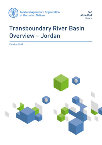
1Jordan transboundaryriver basinGEOGRAPHY, CLIMATE AND POPULATIONGeographyThe Jordan River Basin is a transboundary basin with a total area of about 18 500 km2 of which40 percent is located in Jordan, 37 percent in Israel, 10 percent in the Syrian Arab Republic, 9 percentin the West Bank, and 4 percent in Lebanon (Lehner et al, 2008) (Table 1). The headwater of the 250 kmlong Jordan River originates from three rivers, the Dan, the Banias and the Hasbani, which merge at apoint 5 km south of the northern Israeli border then flow south through the Hula Valley to join LakeTiberias. With the outflow of the Jordan River from Lake Tiberias, the Lower Jordan River receives thewater from its main tributary, the Yarmouk River. The Yarmouk River originates in Jordan, then formsthe border between Jordan and the Syrian Arab Republic and then between Jordan and Israel, beforeflowing into the Lower Jordan River. The river then continues flowing south, forming the borderbetween Israel and the West Bank to the west and Jordan to the east and finally ends in the Dead Sea(Green Cross Denmark, 2006).TABLE 1Country areas in the Amazon River BasinAreaBasinJordankm218 500% of theMiddle East0.28Countries orterritories includedJordanIsraelSyrian Arab RepublicWest BankLebanonArea ofAs % of total As % of totalcountry inarea of thearea of thebasin (km2)basincountry7 47040.48.46 83036.932.91 91010.31.01 6208.828.76703.66.4Ecosystems in the region are extremely diverse, ranging from sub-humid Mediterranean environmentsto arid climates across very small distances. Climate projections for the eastern Mediterranean indicatefuture aridification (GLOWA, 2007). The average annual precipitation in the basin is estimated at 380mm, although it varies all along the basin area (New et al, 2002). The Upper Basin, north of LakeTiberias, has an annual precipitation of up to 1 400 mm, while the Lower Jordan Basin has an averageannual precipitation rate of 100 mm only at its southern end. The largest part of the fertile land in thebasin is located in Jordan and the West Bank, along the eastern and western banks of the Jordan Riverand the side wadis, in an area with annual rainfall of less than 350 mm. Other portions of the catchmentarea in the Syrian Arab Republic and Israel enjoy higher annual rainfall, more than 500 mm per year(Venot et al, 2006). The average annual temperature of the entire Jordan River Basin is around 18 ºC.The average temperature of the Jordan River Basin in January is 9 ºC, although it can drop to 5 ºC in thecoldest places. In August, the average temperature of the Jordan River Basin reaches 26 ºC, rising to 30ºC in the hottest places (New et al, 2002).
2Irrigation in the Middle East region in figures - AQUASTAT Survey - 2008Figure 1Jordan River Basin
Jordan transboundary river basin3WATER RESOURCESThe Upper Jordan River Basin, north of Lake Tiberias, contributes the vast majority of the water whilethe Lower Jordan River Basin, which represents 40 percent of the entire Jordan River Basin, makes amuch smaller contribution (Venot et al, 2006). The Yarmouk River, which is the main water course inthis latter part of the Valley, joins the Jordan River in an area partly occupied by Israel. During thesummer, most side streams dry up completely and capturing the winter floodwaters is one of the mostcritical aspects of water resources management in the Jordan River Basin. If these waters are not divertedor stored, they flow directly to the Dead Sea (Green Cross Italy, 2006).The total natural discharge of the basin is subject to extreme seasonal and annual variations. In February,for example, the river may carry as much as 40 percent of its total annual flow, but in each of the summerand autumn months, when water is most needed, it carries only 3–4 percent of its annual discharge. Indrought periods like 1987–91 the water discharge of the Jordan River Basin can be reduced by up to40 percent over the whole year (Libiszewski, 1995). The annual flow entering Israel corresponding tothe Jordan Basin includes 138 million m3 from Lebanon (Hasbani River), 125 million m3 from the SyrianArab Republic and 20 million m3 from the West Bank. The natural annual flow of the Yarmouk Riverfrom the Syrian Arab Republic to Jordan is estimated at 400 million m3. However, the total actual flowat present is much lower as a result of the drought and upstream Syrian development works done in the1980s. The Yarmouk River is the main source of water for the King Abdullah Canal (KAC), thebackbone of development in the Jordan Valley. A main tributary of the Jordan River in Jordan,controlled by the King Talal Dam and also feeding the KAC, is the Zarqa River. There are also 6–10small rivers, called “Side Wadis”, going from the mountains in Jordan to the Jordan Valley.Surface water accounts for 35 percent of the existing water resources in the basin, groundwater aquifersaccount for 56 percent of the resources, while reused wastewater and other non-conventional sources ofwater represent around 9 percent. The surface water of the Jordan River Basin is the main surface waterresource available for relatively stable use in the region. It is the major source of water for Israel andJordan and also supports the many aquifers in both countries, extending the reliance on the river (GreenCross Italy, 2006). The three main aquifers in the system are west of the Jordan River and are central tothe water supply of Israel, Jordan and the Occupied Palestinian Territories: the western (or mountain)aquifer, the northeastern aquifer, and the eastern aquifer.The region has one of the lowest per capita water resources worldwide, well below the typical absolutewater scarcity threshold of 500 m3/year per capita, except for Lebanon (Table 2). Moreover, waterdemand continues to increase rapidly due to high population growth rates and economic development.TABLE 2Internal and total actual renewable water resources per capita in 2006 in m 3/yearCountry or TerritoryIsraelJordanLebanonOccupied Palestinian TerritorySyrian Arab RepublicInternal renewablewater resourcesTotal actual renewablewater resources1101191 1842093672611641 110215865Water qualityDue to the continuous drop in water levels in Lake Tiberias since 1996, in 2001 regulations in Israellowered the minimum “red line” from 213 m below sea level to minus 215.5 m. The risks associatedwith reduced water levels are enormous: ecosystem instability and deterioration of water quality,damage to nature and landscape assets, receding shorelines and adverse impacts on tourism andrecreation. Salinity in the lake has been alleviated by diverting several major saline inputs at thenorthwest shore of the lake into a “salt water canal” leading to the southern Jordan River. This canalremoves about 70 000 tonnes of salt (and 20 million m3 of water) from the lake each year. The salt water
4Irrigation in the Middle East region in figures - AQUASTAT Survey - 2008canal is also used to remove treated sewage from Tiberias and other local authorities along the westernshoreline away from Lake Tiberias and into the lower Jordan River. In the catchment area, a concertedeffort has been made to lower the nutrient load by changing agricultural and irrigation practices, bycutting back the acreage of commercial fishponds and by introducing new management techniques.Sewage treatment plants have been improved and a new drainage network that recycles most of thepolluted water within the watershed has been constructed. Around the lake, public and private beachesand recreation areas with appropriate sanitary facilities have been developed. Pollution and sewage fromsettlements and fishponds near the shores are treated and diverted from the lake.Much of Amman’s wastewater treated effluent is discharged in the Zarqa river and is impounded by theKing Talal Dam, where it gets blended with fresh floodwater and is subsequently released for irrigationuse in the jordan valley. The increased supply of water to Jordan’s cities came about at the expense ofspring flows discharging into such streams as the Zarqa River, Wadi Shueib, Wadi Karak, Wadi Kufrinjaand Wadi Arab. The flow of freshwater in these streams has been reduced as a result of increasedpumping from the aquifers, and the flow has been replaced with the effluent of treatment plants, aprocess that has transformed the ecological balance over time.WATER-RELATED DEVELOPMENTS IN THE BASINThe total area equipped for irrigation in the Jordan River Basin is estimated at 100 000–150 000 ha, ofwhich approximately 32 percent in Jordan, 31 percent in Israel, 30 percent in the Syrian Arab Republic,5 percent the Occupied Palestinian Territory, and 2 percent in Lebanon. Agricultural water withdrawalis approximately 1.2 km3.In Jordan, intensive irrigation projects have been implemented since 1958, when the Governmentdecided to divert part of the Yarmouk River water and constructed the East Ghor Canal (later namedKing Abdullah Canal or KAC). The King Talal Dam on the Zarqa River also diverts the water into theKAC. The canal was 70 km long in 1961 and was extended three times between 1969 and 1987 to reacha total length of 110.5 km. The construction of dams on the side wadis and the diversion of the flowsfrom other wadis have allowed the development of irrigation over a large area. At the same time, wellshave been drilled in the Jordan Valley to abstract groundwater, not only for domestic purposes but alsofor irrigation. Irrigation projects from surface water resources are mainly located in the Jordan RiverValley (JRV) and the side wadis linked with the Jordan River Basin. Irrigation schemes in the JRV havebeen constructed, rehabilitated, operated and maintained by the government. In the first projects in thenorth, concrete-lined canals were constructed equipped with all irrigation structures to convey anddistribute irrigation water on volumetric basis. Additional irrigation schemes were constructed duringthe 1970s and 1980s following the extension of the KAC, and through the construction of dams, anddiversion of side wadis springs and streams. From the 1990s onwards the open canal irrigation schemeswere converted to pressurized irrigation systems.Israel has constructed the Cross Israel Water Carrier, which starts at the northern end of Lake Tiberiasand diverts water via massive pipelines across the Jezreel Valley and south along the coastal plain,terminating in Beersheba. Across Israel, the government has built smaller pipelines radiating out overthe farmland to bring water for irrigation. The entire system, completed in 1964, forms a water grid,easily controlled and measured.In the West Bank, localized irrigation systems are used to irrigate vegetables. A small percentage ofvegetables is still irrigated by traditional methods, as well as the majority of citrus trees. Farmers usuallyuse plastic lined pools to store their shares of fresh spring water and mix them with brackish well water.Then water is pumped and applied through trickle irrigation systems. From nearly all wells water ispumped into steel pipes which convey the water to the irrigation systems directly in the farms. As thepumping costs are high, the cost per unit water is high and thus farmers need to improve distributionand conveyance efficiency through the use of pipes.
Jordan transboundary river basin5In the Syrian Arab Republic surface irrigation is the prevailing irrigation system. Basin irrigation is thepredominant technique used in surface irrigation and most of the irrigated wheat and barley are irrigatedby this method. Irrigation field efficiency is reportedly to be in general below 60 percent.Table 3 shows the large dams in the Jordan River Basin, i.e. dams with a height of more than 15 metresor with a height of 5–15 metres and a reservoir capacity larger than 3 million m3 according to theInternational Commission on Large Dams (ICOLD).TABLE 3Large dams in the Jordan River BasinCountryJordanJordanSyrian Arab Republic*NameNearest cityRiverYear198719981986King TalalKaramahJarashAl-Balqa (J)Zarqa RiverWadi Al MallahaWadi ArabIrbidWadi ArabShurabil Bin Hasna IrbidKafreinAl-BalqaShueibAl-BalqaIrbid (J)Wadha (Unity)Dara (S)Wadi ZiglabWadi KafreinWadi ShueibYarmouk River1967199719692007HeightCapacity(m)(million m3)108754553842048373287492110Total273Main use *I, F, H, NI, F, RI, W, F, N,RI, W, FI, F, R, OI, F, OI, W, F, O,HI irrigation; H Hydropower, W water supply; F Flood protection; R recreation; N Navigation; O OtherTRANSBOUNDARY WATER ISSUESWhile the idea of developing a water sharing strategy for the whole basin was recognized as early as1913, when the Franjieh Plan was proposed, and 1955, when the Johnston Plan was devised, not onesingle plan has been completely adhered to. The Franjieh Plan was intended for the irrigation of theJordan Valley, to generate hydropower and to transfer Yarmouk River flow (100 million m3) to LakeTiberias (Sofer et al., 1999). The Johnston Plan called for the allocation of 55 percent of available waterin the basin to Jordan, 36 percent to Israel, and 9 percent to the Syrian Arab Republic and Lebanon.However, it was never signed by the countries involved.In 1951, Jordan announced its plan to divert part of the Yarmouk River via the East Ghor Canal toirrigate the East Ghor area of the Jordan Valley. In response, Israel began the construction of its NationalWater Carrier (NWC) in 1953. In 1964, the NWC opened and began diverting water from the JordanRiver Valley. This diversion led to the Arab Summit of 1964, where a plan was devised to begindiverting the headwater of the Jordan River to the Syrian Arab Republic and Jordan. From 1965 to 1967Israel attacked these construction projects in the Syrian Arab Republic and along with other factors thisconflict escalated into the Six Day War in 1967 when Israel completely destroyed the Syrian diversionproject and took control of the Golan Heights, the West Bank, and the Gaza Strip. This gave Israelcontrol of the Jordan River’s headwater and of significant groundwater resources. The most recent directwater-related conflict occurred in 1969 when Israel attacked Jordan’s East Ghor Canal due to suspicionsthat Jordan was diverting excess amounts of water (Green Cross Italy, 2006). Later on, Israel and Jordanacquiesced to the apportionment contained in the non-ratified 1955 Johnston Plan for sharing the JordanRiver Basin’s water (Milich and Varady, 1998). In 1978, Israel invaded Lebanon, giving Israeltemporary control of the Wazzani spring/stream feeding the Jordan River (Attili et al., after 2003).Inter-Arab conflicts have also often arisen, but have only been small-scale low-level conflicts. The termsof the 1987 agreement between the Syrian Arab Republic and Jordan defined the Syrian share of theYarmouk and limited the Syrian Arab Republic to building 25 dams with a holding capacity of156 million m3. To date, the Syrian Arab Republic has built 37 dams on the four recharge wadis of theYarmouk River with a total holding capacity of 211 million m3 (i.e. 55 million m3 in violation of theagreement). The Syrian Arabs Republic’s continuous well drilling in the Yarmouk Basin negativelyimpacts the base flow in the river, reducing it by approximately 30 percent (Green Cross Italy, 2006).The Wadha (Unity) Dam on the Yarmouk River was included in the agreement, with a height of 100 mand a storage capacity of 225 million m3. Jordan would receive 75 percent of the water stored and the
6Irrigation in the Middle East region in figures - AQUASTAT Survey - 2008Syrian Arab Republic would receive all of the hydropower generated. In 2003 the height of the dam wasreduced to 87 m and the storage capacity became 110 million m3. The dam was completed in 2007.Since the start of the Peace Process in the early 1990s, bilateral agreements and common principles havebeen signed between Israel and Jordan and Israel and the Palestinian Authority, but no multilateral planor agreement has been negotiated and even the bilateral ones have been put under pressure andfrequently violated in times of natural or political crisis.In July 1994, Israel and Jordan signed The Washington Declaration and negotiated the Treaty of Peace,signed in October 1994. The treaty spells out allocations for both the Yarmouk and Jordan rivers andcalls for joint efforts to prevent water pollution. This peace treaty established the Israel–Jordan JointWater Committee (IJJWC), comprised of three members from each country. The Committee was taskedto seek experts and advisors as required, and form specialized subcommittees with technical tasksassigned. The two countries undertook to exchange relevant data on water resources through the IJJWCand also agreed to cooperate in developing plans for purposes of increasing water supplies andimproving water use efficiency. It also specified the volumes of water to be used, stored, and transferredby and to each country during a “summer” and a “winter” season (Milich and Varady, 1998). Jordan isentitled to store 20 million m3 of the Upper Jordan winter flow on the Israeli side (in Lake Tiberias) andget it back during the summer months. Jordan can build a dam on the Yarmouk downstream of thediversion point of Yarmouk water to the KAC. Jordan can also build a dam of 20 million m3 capacityon the Jordan River and on its reach south of Lake Tiberias on the border between Jordan and Israel.Because Israel is to provide only 50 million m3/year of additional water to Jordan, insufficient to allowthe Jordanians to cover their annual deficit, the two countries have agreed to cooperate in finding sourcesto supply Jordan with an additional quantity of 50 million m3/year of water of drinkable standards, withinone year from the entry into force of the treaty. To protect the shared water of the Jordan and Yarmoukrivers against any pollution or harm, each country is to jointly monitor the quality of water along theirboundary, building monitoring stations to be operated under the guidance of the IJJWC. Israel andJordan are each to prohibit the disposal of municipal and industrial wastewater into the Yarmouk orJordan River before treatment to standards allowing unrestricted agricultural use (Milich and Varady,1998).Interpretation of several terms of the treaty has at times had an uneven history. On the positive side isthe June 1995 completion of a pipeline making the physical connection between the Jordan Riverimmediately south of its exit from Lake Tiberias and the King Abdullah Canal in Jordan. Moreover, theprovision of the additional 50 million m3/year that Israel promised to Jordan went ahead on schedule.However, the article which calls for cooperation so that Jordan acquires 50 million m3 more per year ledto a “mini crisis” between the two countries in May 1997. At the heart of the dispute was Jordan’sdemand for an immediate transfer of 50 million m3, which was to have been obtained by the constructionof two internationally financed dams in Jordan. However, neither Jordan nor Israel was successful inobtaining the necessary financing. Finally, Israel agreed to supply Jordan with 25 million m3 of waterper year for three years as an interim solution, until the desalination plant is erected.Recent dialogue and peace treaties have lead to increased cooperation regarding the development offuture water resources projects. For instance, the 1994 and 1997 Israel–Jordan agreements led todiscussions on the possibility of building a canal from the Red Sea to the Dead Sea to producedesalinated water with hydropower. It should be mentioned, however, that in their fervour to reach anaccord, apparently both the Jordanians and the Israelis negotiated without coordinating their moves withthe relevant ministries. Therefore, important issues remain open or vague and conflicts have arisen as aresult. For example, in 1999, due to drought Israel decided to reduce the quantity of water piped toJordan by 60 percent, which caused a sharp response from that country. Disputes of such nature are notunexpected in the future. However, the peace agreements have had the benefit of restricting suchconflicts to political rather than military solutions. The fact that the Joint Water Commission for Israeland the Palestinian Authority have continued to meet to discuss critical issues even during the currentperiod of hostilities illustrates the progress that has already been made (Green Cross Italy, 2006).
Jordan transboundary river basin7More than 30 years of Israeli occupation of the West Bank and Gaza Strip have been accompanied witha series of laws and practices targeting Palestinian land and water resources. In 1993, the “Declarationof Principles on Interim Self-Government Arrangements” was signed between Palestinians and Israelis,which called for Palestinian autonomy and the removal of Israeli military forces from Gaza and Jericho.Among other issues, this bilateral agreement called for the creation of a Palestinian WaterAdministration Authority and cooperation in the field of water, including a Water DevelopmentProgramme prepared by experts from both sides, which will also specify the mode of cooperation in themanagement of water resources in the Occupied Palestinian Territory. Between 1993 and 1995, Israeliand Palestinian representatives negotiated to broaden the provisional agreement to encompass thegreater West Bank territory. In September, 1995, the “Israeli-Palestinian Interim Agreement on the WestBank and the Gaza Strip”, commonly referred to as “Oslo II”, was signed. The question of water rightswas one of the most difficult to negotiate, with a final agreement postponed for inclusion in thenegotiations regarding final status arrangements. However tremendous compromise was achievedbetween the two sides: Israel recognized the Palestinian water rights – during the interim period aquantity of 70–80 million m3 should be made available to the Palestinians – and a Joint WaterCommittee was established to manage cooperatively West Bank water and to develop new supplies.This Committee also supervises joint patrols to investigate illegal water withdrawals. No territorywhatsoever was identified as being necessary for Israeli annexation due to access to water resources(Wolf, 1996). In 2003, the Roadmap for Peace, developed by the United States, in cooperation with theRussian Federation, the European Union, and the United Nations (the Quartet), was presented to Israeland the Palestinian Authority to seek a final and comprehensive settlement of the Israel–Palestinianconflict.The basis for Israeli–Syrian negotiations is the premise of an exchange of the Golan Heights for peace(Wolf, 1996). In 1967 Israel seized the Golan Heights from the Syrian Arab Republic during the six-daywar. The Golan Heights control the main water sources of Israel. Israel’s only lake and its main sourceof freshwater, supplying the country with a third of its water, is fed from the Golan Heights. The GolanHeights, conquered in 1967, have been under Israeli law, jurisdiction, and administration since 1981,which, however, has not been recognized by the United Nations Security Council. The crux of theterritorial dispute is the question of which boundaries Israel would withdraw to; the boundaries betweenIsrael and the Syrian Arab Republic have included the international boundary between the British andFrench mandates from 1923, the Armistice Line from 1949 and the cease fire lines from 1967 and 1974.The Syrian position has been to insist on a return to the borders of 1967, while Israel refers to theboundaries of 1923. The only distinction between the two lines is the inclusion or exclusion of the threesmall areas with access to the Jordan and Yarmouk rivers (Wolf, 1996). In 2008, negotiations betweenIsrael and the Syrian Arab Republic started with the objective to solve the conflict of the Golan Heights.In 2002, the water resources of the Hasbani Basin became a source of mounting tensions betweenLebanon and Israel, when Lebanon announced the construction of a new pumping station at the Wazzanisprings. The springs feed the Hasbani River, which rises in the south of Lebanon and crosses the frontier(‘Blue Line’) to feed the Jordan River and subsequently the Sea of Galilee, which is used as Israel’smain reservoir. The pumping station was completed in October 2002. Its purpose was to providedrinking and irrigation water to some 60 villages on the Lebanese side of the Blue Line. The Israeliscomplained about the lack of prior consultation whereas the Lebanese contended that the project wasconsistent with the 1955 Johnston Plan on the water resources of the region.In 2004 and 2005 Jordan got only around 119 and 92 million m3/year from the Yarmouk River and fromLake Tiberias respectively. This is only around 10 percent of the total flow of the Upper Jordan andYarmouk rivers. It is also much less than the water share from these two basins proposed by the Johnstonplan through his negotiations in 1950s.In 2007, Jordan and the Syrian Arab Republic agreed to expedite the implementation of agreementssigned between the two countries, especially with regards to shared water in the Yarmouk River Basin.They also agreed to continue a study on the Yarmouk River Basin based on previous studies. Currently,the Joint Jordanian–Syrian Higher Committee is discussing how to make use of the Yarmouk River
8Irrigation in the Middle East region in figures - AQUASTAT Survey - 2008Basin water and how to protect Yarmouk water against depletion. Talks will also include preparationsfor winter and storage at the Wadha (Unity) Dam in the Yarmouk River.Table 4 shows the main historical events in the Jordan River Basin.TABLE 4Chronology of major events in the Jordan River BasinYearPlans/Projects /Treaties/ConflictsCountries, territoriesor organizationsinvolvedMain aspects1913Franjieh PlanOttoman ComissionIrrigation Jordan Valey, transferring Yarmouk Riverflows to Lake Tiberias, generating electricity1951Jordan announced PlanJordanJordan Plan to divert part of the Yarmouk River viathe East Ghor canal1953Israel begun construction of NationalWater Carrier (NWC)IsraelResulting in military skirmishes between Israel andthe Syrian Arab Republic.1955Johnston PlanUSA. RipariancountriesAllocation of water: 55% for Jordan, 36% for Israel,9% each to the Syrian Arab Republic and Lebanon.Not signed because Arab riparians insisted the USAwas not impartial1964The NWC opened and began divertingwater from the Jordan River ValleyIsraelThis diversion led to the Arab Summit of 19641964Arab SummitArab LeagueA plan was devised to begin diverting theheadwaters of the Jordan River to the Syrian ArabRepublic and JordanIsrael, Syrian ArabRepublicThis conflict, along with other factors escalated inthe Six Day War in 1967Egypt, Israel, Jordan,Syrian Arab Republic,Occ. PalestinianTerritoryIsrael destroyed Syrian diversion project and tookcontrol of Golan Heights, WB and GS. Palestinianirrigation pumps on the Jordan River weredestroyed or confiscated after Six Day War andPalestinians are not allowed to use Jordan Riverwater. Israel introduced quotas on existingpalestinian irrigation wells and didn't allow newones.1965- Israel attacked construction projects in1967 the Syrian Arab Republic1967Six Day War1969Israel attacked Jordan's East GhorCanalIsrael and JordanBeacause of the suspicions that jordan wasdiverting excess amounts of water. Later on, Israeland Jordan acquiesced to the apportionmentcontained in the non-ratified Johnston Plan.1978Israel's invasion of LebanonIsrael and LebanonGiving Israel temporary control of the Wazzanispring/stream feeding the Jordan1987Syrian Arab Republic and JordanagreementSyrian Arab Republicand JordanDefined the Syrian share of the Yarmouk and limitedthe Syrian Arab Republic to 25 dams with a capacityof 156 million m3. The Wadha (Unity) Dam wasincluded.1993Declaration of Principles on InterimSelf-Government ArrangementsIsrael, Occ.Palestinian TerritoryCalled for Palestinian autonomy. Creation of thePalestinian Water Administration Authority. WaterDevelopment ProgramIsrael and JordanIsrael and Jordan signed The Wa
The Jordan River Basin is a transboundary basin with a total area of about 18 500 km2 of which . flowing into the Lower Jordan River. The river then continues flowing south, forming the border . drought periods like 1987-91 the water discharge of the Jordan River Basin can be reduced by up to