Transcription
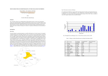
THE WATER OF THE AWASH RIVER BASIN A FUTURE CHALLENGE TO ETHIOPIAFig.1 The main river basins in Ethiopia.Girma Taddese1 , Kai Sonder2 & 3 Don Peden1g.taddesse@cgiar.org ,/girma55@yaoo.com ,2s.kai@cgiar.org & d.peden@cgiar.orgIt is a dilemma why Ethiopia is starving while it has huge amount of surface water and perennial rivers.It appeared that in the past Ethiopia was only utilizing the Awash River Basin for irrigationdevelopment, it accounts for 48% of the national irrigation schemes (FAO, 1995). Thus it is timely toassess the complex situation of the Awash River Basin.ILRIP.O.Box 5689 Addis Ababa EthiopiaSummary1210Number affected(million)The Awash River Basin faces land degradation, high population density, natural water degradationsalinity and wetland degradation. Already desertification has started at lower Awash River Basin. In thehigh land part deforestation andsedimentation has increased in the past three decades. As more water isdrawn from the river there could be drastic climate and ecological changes whichendanger the basinhabitat and h uman livelihood. Draining the wetlands for irrigation could imbalance the sustainability ofthe basin.864Introduction2Over View01965 1969 1973 1977 1978 1979 1983 1984 1985 1987 1989 1990 1991 1992 2003Currently Ethiopia’s agriculture depends on rainfall with limited use of water resources for irrigation.At approximately 50% of the GDP, agriculture, most of it based on rain -fed small -holder systems andlivestock, contributes by far the largest part of the economy and is currently growing on average 5%per year. Highly variable rainfall, frequent floods and droughts, and limited storage capacity continueto constrain the ability of the country to produce reliable food supplies in spite of being relatively richin water and land resources. Ethiopia has an estimated 3.7 million hectares of irrigable land, yet onlyabout 200,000 hectares (5.4%) is presently irrigated and only provides approximately 3% of thecountry's food crop requirements. Despite this, the country could still face more than 6 million tons ofcereal deficits by the year 2016 (UK Trade and Investment 2004). High population pressure decline ofland holding per household, low production and income, abandoning of fallow practices, loss of soilfertility, and increasing demand for fuel energy and construction, materials deforestation, loss of soiland water resources are a challenge to Ethiopia for the coming years. Ethiopia has several river basins(Figure 1).The draught history in Ethiopia shows that draught occurrences vary from year to year(Figure 2). Much of the water resources in Ethiopia are not utilized to meet the food demand(Table 1).Drought yearsFig. 2 Drought hist ory in Ethiopia: Source: Fiona Flintan and Imeru Tamrat, 2002.Table 1. Ethiopia’s Surface Water Resources by Major River Basins (Mm3 ).No.River Basin123456789101112AbbayAwashBaro - AkoboGenale - DawaMerebOmo - G i b eRift ValleyTekezeWabe ShebeleAfar - 00077,1002,2001,136,816Annual Runoff(BM pecific Discharge(1/s K m2)7.81.49.71.23.26.73.43.20.5-
Water resourcesDescription of the BasinThe Awash River Basin is the most important river basin in Ethiopia, and covers a total land area of110,000 km2 and serves as home to 10.5 million inhabitants. The river rises on the High plateau nearGinchi town west of Addis Ababa in Ethiopia and flows along the rift valley into the Afar triangle, andterminates in salty Lake Abbe on the border with Djibouti, being an endorh eic basin. The total lengthof the main course is some 1,200 km. Based on physical and socio-economic factors the Awash Basinis divided into Upland (all lands above 1500m asl), Upper Valley, Middle (area between 1500m and1000m asl), Lower Valley (area between 1000m and 500m asl) and Eastern Catchment (closed sub basin are between 2500m and 1000m asl), and the Upper, Middle and Lower Valley are part of theGreat Rift Valleys systems (Figure 3). The lower Awash Valley comprises the deltaic alluvial plains inthe Tendaho, Assaita, Dit Behri area and the terminal lakes area. The Rift Valley part of the Awashriver basin is seismically active. The international border region of South-Western Djibouti and North Eastern Ethiopia also named the Afar Depression or the Afar Triangle or the Danakil desert, is a resultof the separation of three tectonic plates (Arabian, Somali and African). Shared between Djibouti,Ethiopia and Eritrea, this region is an arid to semi -arid region.Fig. 3 Elevation map of Awash Basin.In general, plateaus over 2,500m receive 1,400 - 1,800 mm yr-1, mid-altitude regions (600 - 2500m)receive 1 000 -1 400mm/year, and lowlands get less than 200 mm y r-1. The rainfall distribution,especially in the highland areas is bimodal, with a short rainy season in March, April and the main rainsfrom June to September (Figure 4). The annual runoff within the basin is estimated at 4.6 km3 (FAO,1997). Some tributaries like Mojo, Akaki, Kassam, Kebene and Mile rivers carry water the whole year,while many lowland rivers only function during the rainy .htm#2.1.2 ).
Potential evapotranspiration (PET) in the Upper Valley at Wonji is 1810 mm over twice of the annualrainfall. At Dupti, the lower Valley the mean annual PET is 2348 mm which is over ten times theaverage annual rainfall. Mean an nual temperatures range from 20.8 o C to 29 oC at Koka and at Duptifrom 23.8 o C to 33.6 oC in June. The mean annual streamflow at Koka is 1.9 m s -1 and in Middle AwashValley exceeds over 2 m s -1 in July.JanuarFebruaryMayJuneSeptembOctobThe Awash River Basin is rich in hot springs. There are eight thermal sites near Dubti town which havehigh perspective for future thermal energy sources. The Koka Dam (11500km2) was commissioned in1960, and the mean annual runoff into Koka reservoir amounts 1660Mm3 . At Awash station the annualrunoff decreases to 1360 Mm3 depleted largely by losses from Koka Dam by Upper Valley irrigationdiversions (Figure 3). Total mean annual water resources of the Awash River Basin amounts to some4900 Mm3 of which some 3850 Mm3 is currently utilized, the balance being largely lost to GedebassaSwamp and elsewhere in the river system (Figure 5).The potential for major ground water development for irrigation is limited in Awash River Basin withthe recharge of 14 -26%. The ground water flow in the basin from the escarpment is towards north -eastto Lake Abe (243 m asl) and to the Danakil depression (-141m bsl). The total ground water recharge is3800 Mm3 y r-1 (UNDEP 1973). There are numerous springs that feed the ground water with high flowvariability 1000 l s-1 in the wet season and less than 10 l/s in the dry season; in the Uplands the depthto the ground varies from 10-250 m, from less than 5 l/s to the high yield of 15-18 l/s. Water quality inthe rift valley area of the basin is poor; at Metahara Fluoride concentrations is 21 mg/l. This exceedsthe WHO recommendation for fluoride concentration in the order of 1mg/l. In general the ground waterquality decreases from the upland to the lower pediment slopes as salinity and fluoride concentrationincreases.2500JulyNovembeMean annual runoff (Mm3)2000March15001000500AprilAugustDecembe0Koka DamAwash stationGedebassaswampTendahoCatchmentsFigure 5. Mean annual runoff (Mm3) at certain catchmentsof the Awahsh River Basin. Source: EVDSA (1989).Fig. 4 Monthly rainfall patterns Awash basin(Data Source: Worldclim 2.0) .
Table 2. Ethnic groups evicted from Awash River Basin.Hydrological balance of Awash River BasinA delicate hydrological balance characterizes the lower Awash River Basin where, in a normal year,inflows equal losses in lakes and wetlands (Table 1). Below Dupti in Ethiopia, no appreciable runofffrom local rainfall reaches the river. The level of Lake Abe thus rises and falls according to the balancebetween inflow and evaporation losses. The available water from rainfall in the basin is 39,845(Mm3 y r-1), 72 % of the rainfall (28383 Mm3/yr) is lost through evapotranspiration, 18 % (7386Mm3 y r -1) runoff and 10% (4074 Mm3 y r-1) is rechargeable water (EDSA 1989).Ethnic groupingsJilleDeterioration of WatershedsAs with other parts of Ethiopia, the upper Awash Basin, and its majo r tributaries have been subjected tomajor environmental stress. The demand for natural resources by the high and fast growing populationremains a major challenge to effective agricultural and forestland management. The high pressure onforest resources i n particular, has led to the exploitation of fragile watersheds and ecosystems that haveresulted in loss of vegetation and subsequent soil erosion in the lower part of the Awash River Basin(Kinfe 1999).Socio- economic characteristics and natural resource managementLand use was based on traditional ownership, although all land officially belonged to the governments.The social organization in the Afar region is governed by a customary law and social structure thatunites several tribes. Land use is specifically adapted to the size and kind of livestock such as cattle,goats, sheep, and camels; the delineation and non utilization of lands, usually reserved for livestockgrazing, for regeneration purposes (Figure 6). Conflict is ongoing in the Awash River Basin, much ofwhich is inter -ethnic and inter-clan in nature (Table 2). Changes to land use had many unwantedimpacts, and most of the pastoralists were evicted from the wet grazing lands for dam construction andirrigation development for sugar cane, horticultural crops and cotton (Fiona Flintan and Imeru Tamrat2002; François Piguet, 2001).ArsiKerryuReason for evictionand displacementEstablishment ofDutch HVA and Shoasugar construction ofKoka Dam andcreation of GalilaLake. Assignment ofland for other urbanand rural developmentprojectsNura Erra s-1960sNone, some practicepastoralism in hillyTibila areas1950snoneSugar canedevelopment MethearaAwash National -1960sResettlements: WagelaborSource: Fiona Flintan and Imeru Tamrat. 2002.Water pollutionThe Awash River basin and the Rift Valley Lakes basin have special water quality problems to whichattention needs to be paid. The Awash River is prone to various types of pollution, with that generatedin the urban conglomerate of Addis Ababa and surroundings being most pronounced . Much of thewastewater, both domestic and industrial, produced in that area reaches the Awash river untreated,seriously polluting the water course. Also because downstream the river water is being used for variouspurposes such as drinking water supply (Nazareth town) and irrigation, public health risks are high.High fluoride concentration in groundwater in and around the Great Rift Valley is a naturalphenomenon having a negative impact on public health. The problem is especially apparent in the RiftValley Lakes basin and also in the Awash Basin. There is very little capacity for wastewater treatmentfor Addis Ababa City; therefore, wastewater is discharged directly into t he natural watercourses of theAkaki River, which eventually joins the Awash River. The Akaki River is an important water sourcefor small farm operations in and around Addis producing vegetables and livestock fodder; it is one ofthe tributaries draining Addis Ababa City to the Awash River. Few rigorous investigations have beenundertaken, but nitrate levels are reported to be above 10 mg l -1 in the surface water, and according toBiru (2002) and Itanna (2002), arsenic (As) and zinc (Zn) are measurably higher in the soils irrigatedby the Akai River (Table 3).Wastewater ReuseBy 2025 urban inhabitants will increase in the Awash Basin. The increase of urban population impliesan increase in competing for water. Certain of sources of waste water, like water from urban centersand drainage water from agricultural lands are used for agricultural production. Already municipalwaste water and drainage water from Addis Ababa city is extensively used by poor people forvegetable production. However, many believe that waste water has potential risks at present .A major health concern in much of the middle and some of the lower Awash River Basin is high levelsof fluorides in the groundwater, which is used as a major source for drinking water (Gizaw 1996;Tadesse et al., 1998). High concentrations of fluoride occurring naturally in groundwater water are amajor source of fluoride intake. It has long been known that excessive fluoride intake carries serioustoxic effects. The long-term use of high- fluoride drinking water results in both dental and skeletalfluorosis, which is found in populations in the Middle and Lower Awash, and the Rift Valley Basin.Fig. 6 Population distribution in the Awash Basin(Source Landscan 2002).
Table 3. Mean concentration of heavy metals (ppb) and pH in Addis Ababa Catchments.StreamsHeavy metalspHMnCrNiAsPbZnSpringsPart per billion .25Source: Tamiru Alemayehu et al., 2003Mean coliform count(CFU/100ml)300250200150100500Aba SamuelAKakiBulbulaGefersa (Raw)Legedadi(Raw)Fig. 7. Mean annual coliform count (CFU/100ml).Source: Tamiru Alemayehu et al., 2003.,Water Borne diseasesIn the Awash Valley, Schistosoma mansoni is found at the higher altitudes (the upper valley) where theintermediate host, Biomphalaria pfeifferi profusely breeds in tertiary and drainage canals of the sugarestates. Schistosoma haematobium, causing urinary schistosomiasis, occurs in the middle and lowervalley (where average temperatures are higher) where the intermediate snail host Bulinus abyssinicusbreeds in the clear marshy waters of swamps in undeveloped flood plains. Health records show thatbefore the development of sugar estates, prevalence was limited to the provinces of Harar, Tigray andthe Lake Tana Basins of Gojam and Gondar. Agricultural development attracted people from theseareas, including people infected with the parasite (Figure 7).Malaria is a serious problem within the Awash basin, the disease being present in all areas below 2000,frequent epidemics having been reported from areas within the basin (WHO, 2004; Abeku et al., 2003;Abeku et al., 2002) (see Fig 8 , some areas showing no incidence of Malaria in the South Western partsof the basin, between Nazreth and the outskirts of Addis Ababa up to 2000 m).Fig.8 Malaria incidences in Awash basin. Source Lite(Source: http://www.who.int/docstore/water sanitation health/agridev/ch6.htmWetland DegradationEthiopia adapted, the Awash Basin Surface Water Resources Master Plan, originally adopted in 1989,the plan focusing on management of the upper parts of the watershed, including development ofirrigation, hydropower and livestock in the catchments area. Three wetlands were proposed forirrigation development. They are: the Becho Plains, the Gedebassa Swamp and the Borkena Swamp. Atpresent some other small wetlands are being turned to agricultural lands and reservoirs for powergeneration or irrigation. At a smaller scale, wetlands are being drained resulting in degradation anddestruction of the natural ecosystem of the basin. Attempts at draining swamps have not taken intoconsideration the existing intensive role of the wetlands in providing dry season grazing and otherbenefits to local communities. In effect the great pluvial lakes in the Afar region are reduced to a fewsmall lakes and swamps, turned into fragile confined ecosystems. The size of Lake Abe has d ecreasedby 67% since the 1930s. For many years, water from the Awash River was used for irrigation. Thissituation as well as recurrent droughts has contributed to the progressive drying up of the lakeexacerbating the situation.Soil Salinity and Water loggingSalinity problems are recognized throughout the Lower Awash Valley. Another common problem indrained marshes and swamps is that soils become infertile and acid because of oxidation of sulphur andproduction of sulphuric acid in the drained soils. In poorly drained soils wilt syndrome to cotton isproduced under anaerobic condition in the presence of easily oxidizeable-organic matter, presentlyhydrogen sulphide and reduction of NO3, Fe, Zn and Cu, this process affects growth of cotton rootcausing damage and other deformation in plants. Development of large scale irrigation projects withoutfunctional drainage system and appropriate water management practices hav e led to gradual rise ofsaline ground water in the Middle Awash region. In effect, development of persistent shallow salinegroundwater, capillary rise due to high evaporation and concentration of the soil solution together withthe natural some seeps contributed to secondary salinization (Fentaw Abegaz and Girma Tadesse1996). Discharge to the groundwater by surplus irrigation water has caused a rise in the water table (0.5
m y r-1 ) in Middle Awash irrigated field and problems with secondary salinity in surface and sub surface soil horizons. On the other hand the Awash River salinity increases from Upland to the LowerValley (Figure 9).0.7Mean water salinity(mmhos cm -1 )0.60.50.40.30.20.10UplandUpper AwashMiddle AwashLower AwashFig. 9 Mean salinity level of Awash River water (mmhos cm-1 ). Source: EVDSA 1989.Fig. 11 Human induced soil degradation in the Awash basin (Source ISRIC, UNEP GRID 1991).Sediment ation and ErosionIrrigation DevelopmentWith three generator units installed (Awash I, II and III), the total power generation capacity of Kokadam is 107 MW with an annual power output of 440 GWh. The average annual soil loss in catchmentsis in the order of 200-300 t/ha or 20,000-30,000 t/km2 (PDRE, 1989). Removal of vegetation coverthrough deforestation and overgrazing, repeated tilling of the soil to prepare fine seedbed and lack ofadequate soil and water conservation is causing the dam to silt up (Figures 10 & 11). Infl ow to thereservoir is heavily laden with sediments, and this has lowered the water volume from the designed livestorage capacity of 1,667 Mm3 to 1,186 Mm3 at present (i.e., loss of 481 Mm3), which is a loss of 30%of the total storage volume of the reser voir (EEPC, 2002).Most of the irrigation schemes in Awash Basin have good reputation in irrigation efficiency whichvaries from 30 to 55 %. In the early 50’s the Koka Dam was built in the basin, which served for hydro electrical generation and irrigation development in the down stream. Soon after the first sugar factorywas established in the basin. Large- scale irrigated farming is common on the floodplain. State farmscontrol some 80% of the irrigated area and smallholder farmers farm the remaining 20% (Table 4) . Ofthe state farm area 92% is grown with cotton, 3% with bananas and 5% with cereals and vegetables.Table 4 . Existing and potential large scale irrigation in Awash River Basin.Sediment Yield(tone 106 y-1)Location35302520151050Upper ValleyMiddle ValleyLower ValleyTotalExisting(ha)23300199002560068800New 0062500151400Source: Fiona Flintan and Imeru Tamrat. tchment area (km2)Aba SamuelKebenaArabaKesemMelka KuntureAwash compensationTendahoFig.10 Sedimentinflow at main catchments of the Awash River Basin : Source: EVDSA (1989).The Awash River basin frequently floods in August/September following heavy rains in the easternhighland and escarpment areas. A number of tributary rivers draining the highlands eastwards canincrease the water level of the Awash River in a short period of time and cause flooding in the lowlying alluvial plains along the river course. Certain areas which frequently, almost seasonally, getinundated are marshlands such as the area between the towns of Debel and Gewane in the vicinity ofLake Yardi and the lower plains around Dubti down to Lake Abe. The third area which often floods is,about 30 kilometres nort h of Awash town in the vicinity of Melka Werer (see map in annex forgeographical location of mentioned places visited). Flooding along Awash River was mainly causedby heavy rainfall in the eastern highlands and escarpment areas of North Shewa and Welo and notbecause of heavy rain in the upper watershed areas (i.e. upstream of the Koka Reservoir). Over theyears soil and water run -off in the escarpment areas have steadily increased as a result of deforestation,the most serious environmental degradation in the escarpment areas being caused by overpopulation inthe highlands (Figure 6). Tributaries to Awash river such as Kessem, Kebena, Hawadi, Ataye Jara,
Mille and Loqiya rivers contributed most to the lowland flooding in Afar. s/awash0999.doc).Ecosystems and biodiversity in the basinVegetationThe Upper Basin Rained area is used by pastoralists during the rainy season because of the higherrainfall and there crop utilization is high (Figure 12).Fig .13 Maj or soil types inthe Awash basin(Source FAO, 1996 ).Fig. 12 Landsat 7 Mosaic of Awash basin in 2000 (Source: GLCF, University of Maryland, NASAGeocover) .The dominant vegetation in the Upper and Middle Valley is grassland with some scrubland and riparianforest along the Awash River. The best wet season grazing areas here are the Alidge, Gewane, Awashand Amibar.Some of the plant species include Balanites aegypticus, Salix subserata, Flueggia virosa,Carissa edulis, Rumex nervosus, Tamarindus indica, Ulcea schimperi and Acacia spp.Lasiurus scindicus, Pa nicum turgidum (highly palatable), in the plains of Gobbad and Hanle,associated with Acacia tortilis, Acacia asak (mainly present in the wadis), Cadaba rotundifolia andSalvadora persica . Sporobolus spicatus , which is typical of saline depressions and swamps, bears signsof some degradation. Hyphaene thebaica (Doum palm) formations are characteristic but stronglydegraded over the area. Lake Abe is a large (180 km ), shallow and saline (170 g /l NaCl) lake, sharedbetween Djibouti and Ethiopia. It is characterized by sulphur emanations, quicksand, hot springs andhydrothermal travertine rock deposits aligned along faults (Figure 13 see Appendix A for detail). Thevegetations vary with agroecological zones (Figure 14).Fig. 14 Agroecological zones in the Awash Basin(Source MOA, 2002 ).
Animal diversityDesertificationThe wild ass lives in open desert country and in lava-strewn hills among the rocks and cliffs, across theplains of the Danakil region and the Awash Valley. The Somali wild ass (Equus asinus somalicus) isof global significance as it is the only existing representative of the African wild ass with only a fewhundred individuals s/mammals/hoofedmammals/somaliwildass.htm)Awash National Park is the oldest and most developed wildlife reserve in Ethiopia. Featuring the1,800- metre Fantalle Volcano, extensive mineral hot-springs and extraordinary volcanic formations,this natural treasure is bordered to the south by the Awash River and lies 225 kilometers east of thecapital,The wildlife consists mainly of East African plains animals, but there are now no giraffe or buffalo ,Oryx, bat- eared fox, caracal, aardvark, colobus and green monkeys, Anubis and Hamadryas baboons,klipspringer, leopard, bushbuck, hippopotamus, Soemmering’s gazelle, cheetah, lion, kudu and 450species of bird all livewithin the park's 720 square kilometers.Awash National Park. 2004. Selemeta. http://www.selamta.net/national parks.htmHydropower on the Awash River BasinThough Ethiopia has substantial hydropower potential it has one of the lowest levels of per capitaelectrical consumption in the world. There are three functional dams in Awash River Basin, AbaSamuel (1.5 GWh/year) commissioned in 1939, Koka (110 GWh/year) commissioned in 1960, AwashII (165 GWh/year) commissioned in 1966, and Awash III (165 GWh/year) commissioned in 1971.Koka was built on the upper Awash for hydropower generation and irrigation developmentdownstream. The dam has served for four decades. In the coming years five additional dams areproposed to be built for hydropower generation and irrigation development in the basin.Environmental and Social AspectsThis presents a significant health hazard from the microbiological contamination to the surface andgroundwater, and concerns that heavy metals are accumulating soils. Few rigorous investigations havebeen undertaken, but nitrate levels are reported to be above 10 mg/l in the surface water, and accordi ngto Biru (2002) and Itanna (2002), arsenic (As) and zinc (Zn) are measurably higher in the soils irrigatedby the Akai River. Akaki River is one of the tributaries draining Addis Ababa City to the Awash River.In the middle and lower Awash the water -related health hazards are malaria and schistosomiasis, whichare reported to be increasing in prevalence and severity. Basic requirements such as water supply,sanitation and health facilities are poor (Waltainformation 2004).The single overriding factor i n the ecology of the Awash Basin is the rapid and continuous increase inpopulation and the adverse effects on the resources of the basin, in particular, on the rapid erosion anddegradation of the upland soils. The high indication of the sediment load is a result of deforestation andless ground cover in the highland of the upper basin.Figure 1 5. Des ertification in Lower Awash Basin, July 2002, Courtesy Girma Taddese .Manifestations of desertification in Awash River Basin include accelerated soil erosion by wind andwater, increasing salinization of soils and near -surface groundwater supplies, a reduction in soilmoisture retention, an increase in surface runoff and stream flow variability, a reduction in speciesdiversity and plant biomass, and a reduction in the overall productivity in dry land ecosystems with anattendant impoverishment of the human communities dependent on these ecosystems. The lowerAwash River Basin is under severe land degradation and desertification (Figure 15). As the few treesare removed for charcoal and fuel wood, salt patches and salt accumulation is appearing over largeareas killing the vegetation cover. In both Middle and Lower Awash River Basin Prosopis Juliflora, anaggressive exotic plant species, is spreading at alarming rates in alluvial fertile land, aroundhomesteads, and in drainage canals and roads. Juloflora believed to have allelopathic potential onindigenous vegetation.
02YearFigure 16 . Horticultural production in Middle Awash RiverBasin. Source: Ethiopian Horticultural Corporation ShareEnterprise (Annual Report 2003).Cotton yield (tonnes/ha)Production (tonnes)Cropping pattern and crop production2.521.510.50Lower AwashProduction (t)265,000260,000Upper AwashFig. 18 Mean Cotton Yield in Awash River Basin. Source: RATES 2004 .The Middle and Lower Awash is one of the major cotton producing areas of Ethiopia. However, duringthe last decades most of the agricultural land has been aban doned as a result of inherent soil salinityand saline shallow ground water. In most of the irrigation project development drainage system werenot built. Thus the irrigated land did not change over time and expanded, as salinity became a majorthreat ford evelopment of agricultural land. Cotton produce after ginning is supplied to local textileindustries (Figure 18).Livestock450040003500Cattle populationtropical Livestock Unit(TLU)The state farms are generally found in the Middle and Lower sections of the valley and the majorirrigators in the upper valley are the Ethiopian Sugar Corporation Ethiopian Share Enterprise (ESC)and Ethiopian Horticultural Corpo ration Share Enterprise (HDC). Historically sugar and cotton havebeen the major crops grown in Middle and Lower Awash Valley .Fruit production has been increasingsince about 1999, with the bulk of fruit and vegetables sold in the local market in all river Basins inEthiopia. The production of high value vegetables for export has recently been introduced in the RiftValley Lake Basin and Awash River basin. In 2001 and 2002 the exported vegetables has increased by95 % as compared to 1998. Among this 45 % of the flower exported comes from the Awash RiverBasin (Figure 16) . As the external market opportunity is growing several private flower enterprises areemerging. In the lower valley of the drier areas where moisture is critical summer cropping pattern iscommon such as cotton. However in the Upper Valley the highest percentage of cropping is occupiedwith sugar cane (Figure 17) . Ethiopia is completely self- sufficient in cotton. This crop holds significantopportunities for export. Existing textile industries demand approximately 50,000 tons of lint cottonannually. In addition, there are good prospects for exporting lint (Figure 18). Opportunities forproduction and processing of cotton in Ethiopia are significant. The prevailing cropping pattern in theupper Valley is sugar cane (74%), in the middle Valley cotton (82%) and in the lower Valley cotton(75%).Middle 92003Year245,000240,0002000200120022003YearFig. 17 Sugar production in Awash River Basin. (Source: Annual report of the Ethiopian SugarIndustry Center Share Company, 2003).Figure. 19. Cattle population in Middle and Lower Awash Valley (AfarRegion).The Awash valley has historically been a main gateway for the caravan trade between the coast and thehighlands of Ethiopia to Djibouti and Berbera. At present, the strategically important official importand export trade activities of the country take place through the pastoral areas of the Afar and Somaliregions. Cross-border trade with neighboring countries is also an important aspect of the economic lifein these pastoral areas of the country. In 2001, the total population of
The Awash River Basin is the most important river basin in Ethiopia, and covers a total land area of 110,000 km 2 and serves as home to 10.5 million inhabitants. The river rises on the High plateau near Ginchi town west of Addis Ababa in Ethiopia and flows along the rift valley into the Afar triangle, and


